LIHI Certifcate #208 - Chicopee Falls Project, Massachusetts
| Project Name | Chicopee Falls |
| LIHI Certificate No. |
208 |
| LIHI Certificate Term |
February 12, 2026 – February 11, 2036 |
| Owner | Chicopee Electric Light Dept. (operated by Ware River Power Inc.) |
| State | Massachusetts |
| Location | River Mile 2.9 on the Chicopee River, Hampden County |
| Installed Capacity | 2.5 MW |
| Average Annual Generation | 8,850 MWh |
| Facility Type | Run-of-river |
| FERC No. | P-6522 exempt issued December 8, 1982 |
The Chicopee Falls Project is located in the City of Chicopee MA and is the second dam on the Chicopee River above its confluence with the Connecticut River. Although the Chicopee River is only 18 miles long, its watershed is 721 square miles, the largest in all of Massachusetts, and the largest tributary watershed to the Connecticut River. During the Industrial Revolution, the Chicopee River became a particularly sought-after destination for hydropower, largely because it drops 260 feet over its course. The dam was originally constructed in 1898 and hydro operations began in 1985.
There are six hydropower facilities on the river including Dwight (LIHI #170) located 1.7 river miles downstream. Moving upstream from Chicopee Falls are Indian Orchard (LIHI #112), Putts Bridge (LIHI #102), Collins (LIHI #88), and Red Bridge (LIHI #96).
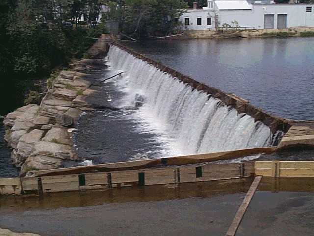
The project consists of a 10-foot-tall, 256-foot-long granite block masonry dam with 1.4-foot-high wooden hydraulic flashboards; a gatehouse structure, non-overflow sluice gate structure, retaining walls, a canal intake with two headgates; two penstocks consisting of 24-foot-wide concrete box and exposed steel sections, each approximately 90 feet long; intakes with steel trash racks with 1-3/4” spacing; a powerhouse containing two ESAC bulb turbines each with 1.25 MW capacity; and appurtenant facilities. The dam creates a reservoir with 310 acre-feet of storage capacity, and a bypassed reach approximately 500 feet long.
The project operates in an instantaneous run-of-river mode monitored by a PLC and SCADA system to maintain stable impoundment levels and minimize fluctuations. An aquatic base flow of 357 cfs is provided below the tailrace and a minimum instantaneous flow equal to or exceeding the 7-day 10 year low flow of 127 cfs is released at the dam into the bypassed reach during operation of the hydroelectric facility for the protection of aquatic resources and water quality.
Waters within the project reach are designated as Class B warm-water fisheries. The waters are also listed as impaired for E. coli and fecal coliform though the likely cause of this impairment is wet weather combined with sewer overflows upstream of the project. Invasive water chestnut is present in the impoundment.
The only migratory fish species currently present in the river is American eel which has been observed upstream of the project indicating that some eels can naturally pass the project. Anadromous species including American shad, sea lamprey, and river herring, as well as many American eels are blocked from access to the Chicopee Falls Project by the downstream Dwight dam which does not have any fish passage requirements. The Chicopee River watershed is not currently the subject of migratory fish management efforts. Resident fish species in the Chicopee River include black bullhead, bluegill, brown trout, rainbow trout, chain pickerel, channel catfish, carp, shiners, sunfish, and bass.
Project lands consist of about 6 acres of land and about 4.4 acres under water. The project is located in a highly developed area although there are narrow vegetated buffers along the impoundment shoreline and along the north side of the bypassed and downstream reaches. Due to the highly developed nature of the area, no lands of significant ecological value exist in the project area. Further, no critical habitats for any endangered or threatened species exists in the project area.
The USFWS indicates that tricolored bat, a species proposed for listing as endangered may be present in the project area. The proposed threatened monarch butterfly may also be present. Since the project is located in an urban area and does not require tree cutting or significant vegetation management, neither of these species are likely to be impacted by project operations. The Massachusetts Biomapper indicates no core habitats or critical natural landscapes are present in the immediate project vicinity.
There are no listed archaeological sites of historic value in the area of the Chicopee Hydropower plant, except for the Deady Memorial Bridge, which carries Route 33 (Memorial Drive) over the Chicopee River adjacent to the dam near the gate house. The Chicopee area was home to Native Americans prior to European settlement. Federally recognized tribes are the Mashpee Wampanoag Tribe and the Wampanoag Tribe of Gay Head (Aquinnah) of Massachusetts. The Nipmuc Nation is a state-recognized tribe.
The project area has limited recreational value. The stretch of the river immediately below the dam is owned by private companies, while other parts of the property are restricted due to public safety. There are non-project portages upstream and downstream and it is likely that informal fishing access exists as well.
Compliance Status
The Certificate includes the following facility-specific condition:
Condition 1: In annual compliance submittals to LIHI, the facility owner/operator shall provide a summary of any agency consultation that has occurred regarding upstream or downstream fish passage. If an agency requests passage studies or passage facilities during the LIHI term, a plan and schedule for implementation will also be provided in the applicable compliance submittal(s).
2026: Annual reporting for the current certificate has not yet taken effect.
Certification History
July 1, 2026: The Low Impact Hydropower Institute has issued a final decision on the certification of the Chicopee Falls Hydroelectric Project (LIHI #208). No appeals were received during the appeal period which closed on June 26, 2026. The 10-year certification term is February 12, 2026 through February 11, 2036.
May 27, 2026: The Low Impact Hydropower Institute (LIHI) has preliminarily approved Low Impact Certification for the Chicopee Falls Hydroelectric Project (pending LIHI #208) located on the Chicopee River in Massachusetts. The full application and reviewer’s report are available below.
This decision is preliminary pending the 30-day appeal window. Only those who commented on the initial applications during the 60-day comment period are eligible to file an appeal. Such appeal needs to include an explanation as to how the Project does not meet the LIHI criteria. Appeal requests can be submitted by email to comments@lowimpacthydro.org with “Chicopee Falls Project” in the subject line, or by mail addressed to the Low Impact Hydropower Institute, 68 Harrison Ave Ste 605, PMB 113938 Boston, Massachusetts 02111-1929. All requests will be posted to the website. The applicant will have an opportunity to respond and any response will also be posted. Requests must be received by 5 pm Eastern time on June 26, 2026. If no appeal requests are received the certification term will be February 12, 2026 through February 11, 2036.
February 18, 2026 The Low Impact Hydropower Institute has received a complete application for Low Impact Certification of the Chicopee Falls Hydroelectric Project. LIHI is seeking public comment on this application. Specifically, we are interested in knowing whether you think the Project meets the LIHI Low Impact Certification Criteria, as revised in the 2nd Edition Handbook in effect at the time of initial application. Please review the program and criteria in LIHI’s Handbook Revision 2.06 and then review the Project’s application materials below. Comments that are directly tied to specific LIHI criteria (flows, water quality, fish passage, etc.) will be most helpful, but all comments will be considered. Comments may be submitted to the Institute by e-mail at comments@lowimpacthydro.org with “Chicopee Falls Project Comments” in the subject line, or by mail addressed to the Low Impact Hydropower Institute, 68 Harrison Ave Ste 605, PMB 113938 Boston, Massachusetts 02111-1929. Comments must be received on or before 5 pm Eastern time on April 19, 2026 to be considered. All comments will be posted to the web site and the applicant will have an opportunity to respond. Any response will also be posted.