LIHI Certificate #14C - Lower Raquette River Project, New York
| Project Name | Lower Raquette |
| LIHI Certificate No. | 14C |
| LIHI Certificate Term |
July 9, 2019 – July 8, 2029 |
| Owner | Erie Boulevard Hydropower, LP, a subsidiary of Brookfield Renewable Energy Group |
| State | New York |
| Location | Located along the Raquette River between river mile 20 and 28 in St. Lawrence County, New York. |
| Installed Capacity | Total: 18.0 MW
Norwood: 3.1 MW East Norfolk: 4.8 MW Norfolk: 7.0 MW Raymondville: 3.1 MW |
| Average Annual Generation | 102,520 MWh |
| Facility Type | modified run of river |
| FERC No. | P-2330 issued in 2002, expires 12/21/2033 |
The Lower Raquette River Project is located on the Raquette River in St. Lawrence County, New York. The Raquette River has a total drainage basin of 1,269 square miles at its mouth and originates in the Adirondack highlands at Blue Mountain Lake, Raquette Lake and Long Lake. The river flows generally north-northwest for more than 146 miles, through Potsdam, New York, and empties into the St. Lawrence River, near Massena, New York. Historically, the river has been developed for waterpower for sawmills, paper mills, tanneries, and other industry.
A total of 19 hydroelectric projects exist on the Raquette River including Piercefield (LIHI #156), Upper Raquette (LIHI #14A), Middle Raquette (LIHI # 14B), and Yaleville (LIHI #157) located between two developments in the Lower Raquette Project.
The project is comprised of four developments: Norwood, East Norfolk, Norfolk, and Raymondville. Raymondville is the first dam on the river. The developments were constructed in 1928 for the sole purpose of power generation.
The project includes four developments:
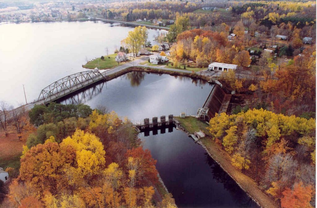
- Norwood: The dam is a concrete-gravity structure, 188 feet long by 24 feet high with 1-foot-high wooden flashboards. It impounds a 350-acre reservoir. The intake structure is concrete with steel trashracks, a skimmer section, and three motor-operated steel sliding gates. There are two timber flood gates, one 9 feet, 9 inches wide by 12 feet high, the other is 12 feet high by 12 feet wide. The concrete log chute has a stop log opening 11 feet, 2 inches by 4 feet, 6 inches high. The powerhouse is made of concrete and brick and contains one 3.1-MW generating unit. The powerhouse is integral to the dam so there is no bypassed reach.
- East Norfolk: The dam is a concrete-gravity structure that consists of a 195 ft long ogee spillway, 28 ft stoplog structure, and an additional 50 ft wide ogee spillway section. The dam impounds a 135-acre reservoir. The concrete intake structure is equipped with steel trashracks, a skimmer section, and an ice chute with a three steel sliding gates. The steel flume is 32-foot wide by 1,398 foot long and oval shaped. The dam creates a bypassed reach approximately 2,100 feet long. The powerhouse contains a single 4.0 MW generating unit.
- Norfolk: The dam is a concrete structure, 380 ft long spillway, 20 feet high with 10-inch flashboards, three 12-foot-wide by 10-foot-high steel headworks gates, and two 9-foot-high by 9-foot-wide sluice gates. The dam impounds a 10-acre reservoir. A power canal extends approximately 1,275 ft downstream from the canal intake and connects to a 14-foot diameter, 715-foot-long woodstave penstock, which transitions to a 14-foot diameter103-foot-long steel penstock that is fitted with a motor-operated butterfly valve. The stave is protected by two steel trashracks and has a skimmer section and a 6-foot wide by 6-foot-high ice sluice. The ice sluice is used for flushing ice and debris downstream. The dam creates a bypassed reach approximately 3,700 feet long. The power canal is 1,275 feet long. The powerhouse is made of concrete and brick and contains a single 4.5 MW generating unit.
- Raymondville: The dam is a 292-foot-wide by 17-foot-high concrete gravity structure with 2-foot-high rubber and steel flashboards. The dam impounds a 50-acre reservoir. There are two 4-foot by 4-foot pond drains and a 48-foot-wide by 447-foot-long concrete power flume with trashracks, an ice chute, and three steel flume intake gates, each 12 feet wide by 10 feet high. The dam creates a bypassed reach approximately 330 feet long. The powerhouse is made of concrete, brick, and steel, and contains a single 2.7 MW generating unit.
The project operates in a run-of-river mode. From 2002 to about 2007, the project developments were operated in a pulsing mode. The normal reservoir fluctuation was limited to no more than 0.5 foot at the Norwood, East Norfolk, and Raymondville developments and no more than 1.0 foot at the Norfolk development. As subsequently modified in 2006 the operation of all the developments was changed from a pulsing mode to a run-of-river mode. This mode of operation targets a normal maximum fluctuation limit of 0.2 feet below the dam crest or top of flashboards. However, up to 0.5 feet of impoundment fluctuation is allowed before an impoundment level deviation notification to the New York State Department of Environmental Conservation (NYSDEC) and the Federal Energy Regulatory Commission (FERC) is warranted. This mode maintains reservoir levels at or near the top of the dam crest or top of flashboard.
Minimum flows are provided at each of the developments and were developed based on a Delphi study. The flow volumes and periodicity at each development were intended to support multiple resource agency management objectives that prioritized restoration of walleye spawning and incubation as the top priority, fish movement, restoration of benthic invertebrate and forage fish production, riparian and wetland production, aesthetics, safety, and water quality. In reaches where little improvement could be made the flow volumes were kept minimal. In reaches where significant benefits were expected, larger volumes and/or longer periods of seasonal flows were established.
- Norwood: A continuous fish conveyance flow of 20 cfs is released for downstream passage;
- East Norfolk: A year-round 75 cfs release is maintained into the bypass reach through the stop log section near the left shore and intake.
- Norfolk: A year-round 75 cfs release is maintained below the confluence of the trash sluice channel and the bypass reach. A release of 55 cfs is maintained from the stop log section of the dam near the right shore and head gates at the upstream end of the bypass reach. A second release of 20 cfs is maintained in the trash sluice channel which enters the bypass reach.
- Raymondville: A fish conveyance flow of 20 cfs is released into the bypass reach for downstream passage. A base flow below the development is also provided which varies depending on river conditions (wet, normal, dry or critically dry years). All flows are spilled from the dam when the development is not operating.
Waters within the project reach are designated as Class C. These waters are managed to achieve and maintain a level of quality that fully support aquatic biota, wildlife, aquatic habitat, swimming and other primary contact recreation, boating, fishing, and other recreational uses. NYSDEC has not identified any impaired waters in the project reach. The project voluntarily built and installed invasive species disposal stations in accordance with NYSDEC design at each development’s boat launch to mitigate the spread of the invasive Eurasian Watermilfoil species. The milfoil species is typically carried from one waterbody to another via recreational boats, kayaks, and canoes.
Upstream passage is provided at the developments for American eel, a catadromous species. An eel passage plan was developed through consultation with the US Fish and Wildlife Service (USFWS) and NYSDEC. The eel passage facilities consist of 18-inch-wide aluminum flumes with solid bottoms, installed with a maximum slope of 45 degrees, one-foot-wide aluminum troughs to convey attraction flows, pumps, and siphons to provide attraction and ladder flows, removable cover plates at East Norfolk, Norfolk, and Raymondville and substrate liners in the flumes. Siphon pipes are used to supply attraction flows of 120 gallons per minute (GPM) and pumps provide 20 GPM into the ladders. The ladders are hinged in the lower sections to prevent damage during high flows, ice and from other debris impacts. Downstream passage for river species is provided via the minimum flow releases at each development. Resident river fish species include a diverse group of game and pan fish. NYSDEC manages the river as a mixed cool-water/warm-water fishery. The most abundant species are walleye, smallmouth bass, northern pike, yellow perch, rock bass, pumpkinseed, and brown bullhead. Trashracks with 1-inch spacing at the developments mitigate the potential for entrainment.
The project boundary consists of over 2,000 acres, including the reservoirs. The overbank areas in the impoundments consist of rural housing and industrial uses. The overbank areas of the Lower Raquette River, located between the developments, consist of agricultural and natural lands of non-significant ecological value.
Threatened or endangered species potentially present in the project vicinity include the Northern long-eared bat, several wintering migratory birds, bald eagle, yellow lampmussel, lake sturgeon, and downy phlox as identified through consultation with NYSDEC. No critical habitat has been identified in the project area for the listed bird species as noted by USFWS. Populations of yellow lampmussel have been determined to be healthy and run-of-river operations mitigate any potential project impact on the species. Similarly, lake sturgeon populations are not expected to be adversely impacted due to project run-of-river operations. Consultation with NYSDEC and USFWS noted presence of downy phlox in an undisclosed location near one development but concluded that operations would not impact the species.
The project was constructed in 1928 but no structures at the developments meet the criteria for listing on the National Register of Historic Places. Additionally, no properties of indigenous religious or cultural significance were identified in the project area despite the close proximity of the project to the St. Regis Mohawk Tribe’s reservation downstream.
Public access is provided free of charge and recreational resources at the project include:
- Norwood: canoe portage, boat launch, picnic facilities, and parking area.
- East Norfolk: canoe portage with parking.
- Norfolk: canoe portage with parking.
- Raymondville: canoe portage, car top boat launch, and picnic facilities with parking.
Compliance Status
The Certificate includes the following facility-specific conditions:
Condition 1: The Facility Owner shall continue to provide annual reports to LIHI in annual compliance submittals that document operational deviations that occurred throughout the year whether unintentional or planned. The report will be due at the same time as the annual compliance statement.
Condition 2: The Facility Owner shall provide status updates in annual compliance submittals regarding any agreements related to the USGS gage relocation and/or other alternatives implemented for stream flow monitoring at Raymondville.
2025: No material changes or compliance issues were identified. The project remains in compliance based on the annual review. For Condition 1, the project reported several minor deviations not considered FERC violations along with one that FERC determined was a violation. For Condition 2, the project reported no change in status.
2024: No material changes or compliance issues were identified. The project remains in compliance based on the annual review. For Condition 1, the project reported several minor deviations not considered FERC violations. For Condition 2, the project reported no change in status.
2023: No material changes or compliance issues were identified. The project remains in compliance based on the annual review. For Condition 1, the project reported several minor deviations not considered FERC violations. For Condition 2, the project reported no change in status.
2022: No material changes or compliance issues were identified. The project remains in compliance based on the annual review. For Condition 1, the project reported several minor deviations not considered FERC violations and one base flow deviation at Raymondville that was considered a FERC violation, although it was of very short duration, the project took corrective actions, made proper agency notifications, and no adverse impacts were identified. For Condition 2, the project reported no change in status.
2021: There were no reported changes or compliance issues. The project remains in compliance based on the annual review. For Condition 1, the project reported several minor deviations not considered FERC violations. For Condition 2, the project reported no change in status.
2020: There were no reported changes or compliance issues. The project remains in compliance based on the annual review. For Condition 1, the project reported four minor deviations not considered FERC violations. For Condition 2, the project reported no change in status.
2019: Annual reporting for the current Certificate has not yet taken effect.
Certification History
January 1, 2022: The LIHI Certificate term has been extended in accordance with Revision 2.05 of the LIHI 2nd Edition Certification Handbook issued January 1, 2022. Refer to the facility table above for the new term.
February 7, 2020: The decision to recertify the Lower Raquette Project became final after the close of the appeals period on February 5, 2020 with no appeals filed. The Certification term is from July 9, 2019 – July 8, 2024.
January 6, 2020: The Low Impact Hydropower Institute has preliminarily approved Low Impact Recertification for the Lower Raquette Hydroelectric Project. This decision is preliminary pending the 30-day appeal window. Only those who commented on the initial application during the 60-day comment period are eligible to file an appeal. Such appeal needs to include an explanation as to how the Project does not meet the LIHI criteria. Appeal requests can be submitted by email to comments@lowimpacthydro.org with “Lower Raquette Hydroelectric Project” in the subject line, or by mail addressed to the Low Impact Hydropower Institute, 329 Massachusetts Ave, Suite 6, Lexington, MA 02420. All requests will be posted to the website. The applicant will have an opportunity to respond and any response will also be posted. Requests must be received by 5 pm Eastern time on February 5, 2020. The full application and reviewers report are available below. If no appeal requests are received and the decision becomes final, the Certification term for the Project will be from July 9, 2019 to July 8, 2024.
August 13, 2019: The Low Impact Hydropower Institute has received a complete application for Low Impact Recertification of the Lower Raquette Hydroelectric Project. LIHI is seeking public comment on this application. Specifically, we are interested in knowing whether you think the Project meets the LIHI Low Impact Certification Criteria, as revised in the 2nd Edition Handbook. Please review the program and criteria in LIHI’s revised Handbook and then review the Project’s application materials below. Comments that are directly tied to specific LIHI criteria (flows, water quality, fish passage, etc.) will be most helpful, but all comments will be considered. Comments may be submitted to the Institute by e-mail at comments@lowimpacthydro.org with “Lower Raquette Project Comments” in the subject line, or by mail addressed to the Low Impact Hydropower Institute, 329 Massachusetts Avenue, Suite 6, Lexington, MA 02420. Comments must be received on or before 5 pm Eastern time on October 12, 2019 to be considered. All comments will be posted to the web site and the applicant will have an opportunity to respond. Any response will also be posted.
May 15, 2015: The Lower Raquette River Hydroelectric Project has been certified for a third term of low impact certification, effective July 9, 2014 and expiring July 9, 2019, with the following conditions:
- Condition satisfied in 2016. Facility owner shall develop a draft Deviation Reduction Plan (DRP) and submit it to LIHI no later than three months after LIHI certification of LRRP. The DRP define proactive operational control approaches for dam releases and pond level maintenance that will reduce the likelihood of operational deviations occurring in the future. The DRP needs to address the specific problems and potential recommendations identified in the reviewer’s report. Options to be considered should include audible alarms in control centers and programmable logic controllers. The DRP shall describe options considered, those selected, and a schedule for implementation. LIHI staff will review and comment on the draft plan and be available to assist in the development of the DRP, if requested. The final DRP needs to be completed and agreed to by both EBH and LIHI no later the six months after LIHI certification.
- Condition continued in 202o certification. Facility owner shall provide annual reports to LIHI documenting operational deviations from instream flow or pond levels that occurred throughout each year of certification. The report shall describe all deviations that have occurred, regardless of whether the deviations were planned or unintentional or whether they are eventually deemed as not violating the license by FERC. The report is due at the same time as the annual compliance statement and payment of the annual certification fee.
In rendering this Certification, the Institute’s Executive Director used authority delegated by the LIHI Governing Board and the unanimous recommendation by the LIHI Governing Board Technical Committee resulting from a full review of the Application Reviewer’s report (available in the Files section below) and all public comments and additional materials provided by the Applicant.
May 12, 2014: The Low Impact Hydropower Institute received an application for a third term of certification of the Raquette River Project. The current certificate term is set to expire on July 9, 2014, but to allow time for public comment and internal review, the term has been extended to August 30, 2014.
April 15, 2010: The Raquette River Project has been certified as low impact for a second five year term, effective July 9, 2009 and expiring July 9, 2014.
October 27, 2004: The Raquette River Project has been certified as low impact for a five year term, effective July 9, 2004 and expiring July 9, 2009.
Certification Files
2019 Recertification
- Lower Raquette Recertification Review Report 2019
- Lower Raquette Recertification Application August 2019
- Norwood Lakefront Owners Association Comment Letter – Lower Raquette Recertification
2014 Recertification
- Lower Raquette Recertification Review Report 2014
- Lower Raquette Recertifcation Application 2014
- US Fish and Wildlife Service Comment Letter – Lower Raquette Recertification
- John Omohundro Comment Letter – Lower Raquette Recertification
2009 Recertification
2004 Certification
- Raquette River Project Certification Review Report
- Raquette River Projects LIHI Application
- Raquette River Projects Certification Application Attachment
Key Documents
- Raquette River FERC license 2002
- Raquette River FERC Environmental Assessment 2001
- Lower Raquette Water Quality Certification 1998
- Lower Raquette Water Quality Certification 2006
- Raquette River Settlement Agreement 1998