LIHI Certificate #14A - Upper Raquette River Project, New York
| Project Name | Upper Raquette |
| LIHI Certificate No. | 14A |
| LIHI Certificate Term |
July 9, 2022 – July 8, 2035 |
| Owner | Erie Boulevard Hydropower, LP, a subsidiary of Brookfield Renewable Energy Group |
| State | New York |
| Location | Located along the Raquette River between river mile 52 and 68 in St. Lawrence County, New York. |
| Installed Capacity | Total: 102.3 MW
Carry Falls: 0 (storage) Stark Falls: 23.9 MW Blake Falls: 13.9 MW Rainbow Falls: 22.8 MW Five Falls: 22.8 MW South Colton: 18.9 MW |
| Average Annual Generation | 460.4 GWh |
| Facility Type | Pulsing |
| FERC No. | P-2060 (Carry Falls ) and P-2084 both issued in 2002, expire 12/31/2033 |
The Upper Raquette River Project is located on the Raquette River in St. Lawrence County, New York. The Raquette River has a total drainage basin of 1,269 square miles at its mouth and originates in the Adirondack highlands at Blue Mountain Lake, Raquette Lake and Long Lake. The river flows generally north-northwest for more than 146 miles, through Potsdam, New York, and empties into the St. Lawrence River, near Massena, New York. Historically, the river has been developed for waterpower for sawmills, paper mills, tanneries, and other industry.
The project is comprised of six developments: Carry Falls (FERC No. 2060), and Stark Falls, Blake Falls, Rainbow Falls, Five Falls, and South Colton (collectively FERC No. 2084). A total of 19 hydroelectric projects exist on the Raquette River including Piercefield (LIHI #156) located upstream, and several downstream including Middle Raquette (LIHI # 14B), Lower Raquette (LIHI #14C), and Yaleville (LIHI #157) located between two developments in the Lower Raquette Project.
The project was originally constructed and began operation over a five-year period from 1952 to 1957, and includes six developments:
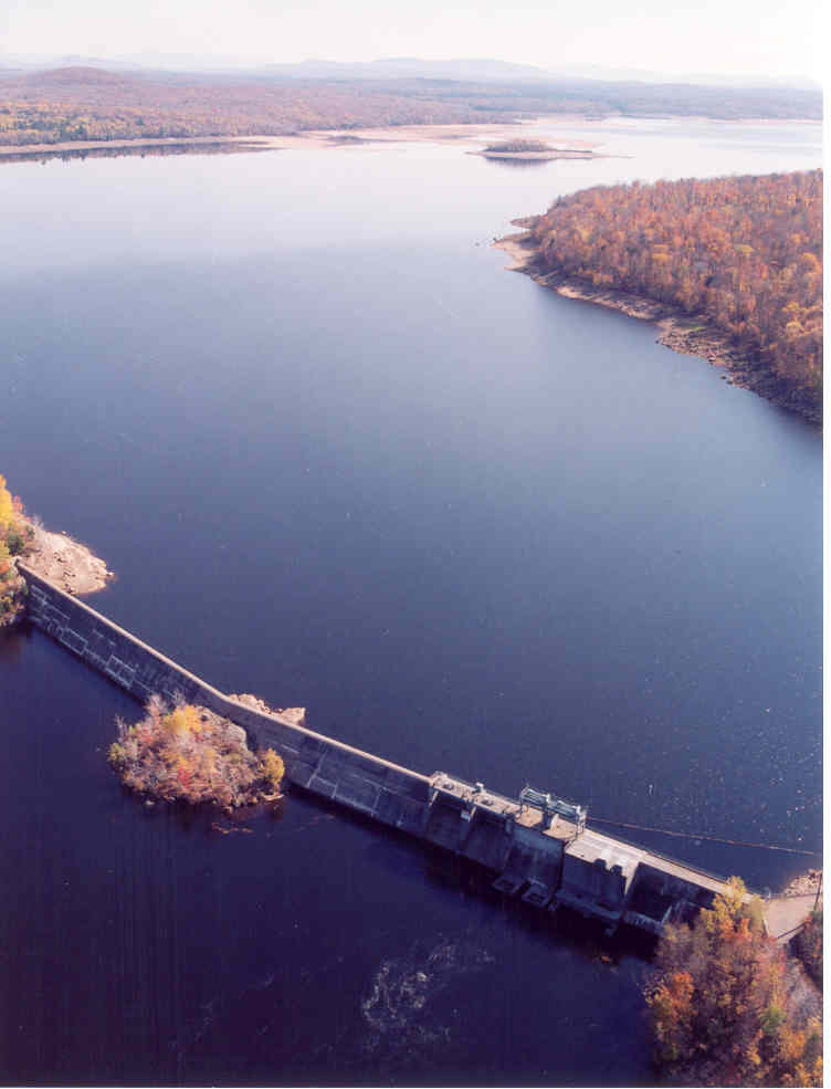
- Carry Falls: The storage dam is 826 feet long with a 548-foot-long, 76-foot-high (maximum) concrete gravity spillway and a 258-foot-long, 63-foot-high concrete gated non-overflow spillway. The non-overflow section includes two 14.5-foot by 27-foot Tainter gates, two 10 by 10-foot low-level sluice gates, and an intake structure with two 15 by 15-foot openings. There are five earth dikes totaling 2,500 feet in length with heights varying from 12 to 31 feet. The dam creates a 7 mile long, 3,000-acre reservoir. There is no hydroelectric production at this development.
- Stark Falls: The dam is a 35-foot-high concrete gravity structure with a 294-foot-long concrete ogee spillway section and a control gate section flanked by earthen dikes. There are a total of seven earthen dikes totaling approximately 3,700 feet in length, an intake with 1-inch clear spaced trashrack, a 651-foot-long, 18-foot-diameter welded steel penstock, and a powerhouse containing a single 23.87 MW vertical Francis turbine/generating unit. The dam impounds a 1.5 mile long, 641-acre reservoir that creates a 1.5-mile-long bypassed reach.
- Blake Falls: The dam is a 60-foot-high (maximum) concrete gravity structure with a 592-foot-long concrete ogee overflow section. Other project works include three earthen dikes totaling approximately 1,840 feet in length, an intake with 1-inch clear spaced trashrack, a 731-foot-long, 18-foot-diameter welded steel penstock, and a powerhouse containing a single 13.91 MW vertical Francis turbine/generating unit. The dam impounds a 5.5 mile long, 660-acre reservoir that creates a 0.85-mile-long bypassed reach.
- Rainbow Falls: The dam is an 81.5-foot-high (maximum) concrete gravity structure with a 751-foot-long concrete ogee overflow section flanked by a 1,600 foot-long earthen dike on the North and a 100-foot-long earthen dike on the South. Additional project works include an intake with 1-inch clear spaced trashrack , a 645-foot-long, 18-foot-diameter welded steel penstock, and a powerhouse containing a single 22.83 MW vertical Francis turbine/generating unit. The dam impounds a 3.5 mile long, 710-acre reservoir that creates a bypassed reach approximately 100 feet long.
- Five Falls: The dam is a 50-foot-high (maximum) concrete gravity structure with a 500-foot-long concrete ogee overflow section flanked at each end by an earthen dike. The South dike is ~290 ft in length and the North dike is ~685 ft in length. The facility has an intake with 1-inch clear spaced trashrack , a 1,399-foot-long, 18-foot-diameter welded steel penstock with a surge tank, and a powerhouse containing a single 22.83 MW vertical Francis turbine/generating unit. The dam impounds a 1.0 mile long, 120-acre reservoir that creates a 0.54-mile-long bypassed reach.
- South Colton: The dam is a 42-foot-high (maximum) concrete gravity structure with a 592-foot-long concrete ogee overflow section and earthen abutments. Other project works include an intake with 1-inch clear spaced trashrack , a 1,220-foot-long, 18-foot-diameter welded steel penstock with a surge tank, and a powerhouse containing a single 18.95 MW vertical Francis turbine/generating unit. The dam impounds a 1.5 mile long, 225-acre reservoir that creates a bypassed reach approximately 0.4 miles long.
The project operates in coordination with the owner’s other developments on the Raquette River, including the Middle and Lower Raquette River Projects. Each of the developments operate in a pulsing mode. The maximum daily reservoir fluctuation limits under normal flow conditions are 1 foot at Stark Falls, Blake Falls and Rainbow Falls and 2 feet at Five Falls and South Colton. Minimum flows were developed through Delphi flow studies and are provided at all developments:
- Carry Falls: Operates under a guide curve to provide flows sufficient to operate the downstream plants and maintain their minimum flows and to ensure that flows downstream of the Raymondville development (part of the Lower Raquette River project) and the last reservoir before the Raquette River empties into the St. Lawrence River, are sufficient for most of the riffle habitat to be adequately watered at all times.
- Stark Falls: A year-round release of 45 cfs is provided through the stop log section of the dam. Should flows be passed through the Tainter gates for a period of 24 hours or more, the release is increased to 90 cfs until 24 hours after the Tainter gates are closed.
- Blake Falls: A year-round release of 55 cfs is provided through the stop log section of the dam with an increase to 120 cfs from the start of walleye spawning season through the end of June.
- Rainbow Falls: A year-round release of 20 cfs is provided through the stop log section of the dam.
- Five Falls: A year-round release of 50 cfs is provided through the stop log section of the dam with an increase to 145 cfs during walleye spawning season.
- South Colton: A year-round release of 20 cfs is provided over the visible portion of the falls.
Waters within the project reach are designated variously as Class B (Carry Falls), Class C trout waters, and a Class D warm water fishery. Class B waters are best used for primary contact recreation and aquatic biota support. Class C trout waters are supportive of fishing and secondary contact recreation. Class D waters are best used for secondary contact recreation. There are no impaired waters in the project reaches and water quality is generally well above minimum standards for New York State Class B waters, and capable of supporting a diverse and healthy cool water aquatic community
No migratory fish species are present in the project’s river reaches which are well above the historic upstream extent of anadromous fish migrations. The downstream Lower Raquette River project has installed upstream passage for the catadromous American eel but resource agencies have not yet prescribed such measures at this project, although authority is reserved to require passage in the future if warranted. Downstream fish passage is provided via the aforementioned minimum flow structures in the dams. Trashracks with 1-inch bar spacing are installed at each development which minimize entrainment potential.
The project lands are mostly located within Adirondack Park. As a result, the area is sparsely populated, with much of the area forested and brush land with only minor development. The project owner divested 12,000 acres of land in the watershed and lands associated with the project, though the divestment is outside the project boundary.
PLUS-Standard: The project owner voluntarily collaborated with NYSDEC to develop land-use practices consistent with adjoining State properties and developed a land use management plan for project lands to manage shorelines previously developed and protect undeveloped properties. In addition, the owner established and funds the Raquette River Raquette River Advisory Council Fund to support management plan activities.
Threatened or endangered species potentially present in the project vicinity include northern long-eared bat, bald eagle, spruce grouse, and Northern clustered sedge. The project has signage near bald eagle nesting sites near Carry Falls detailing the eagle’s presence to deter boaters from adversely impacting the species. A bald eagle protection and management plan includes a provision for annual reporting of NYSDEC bald eagle observations within the project area.
Based on consultation with the New York State Historic Preservation Office, no historic or cultural properties exist in the project area. A historic properties management plan was developed to provide guidance should any properties be identified and annual reports of any ground-disturbing activities are filed.
Public access is provided free of charge and recreational resources at the project include:
- Carry Falls: Jordan River canoe portage, Carry Falls Dam canoe portage, Parmenter Campground, open seasonally from Memorial Day weekend through Labor Day weekend (fee-based) but remains open free-of-charge through to Thanksgiving Day. Other facilities include a trailer-accessible boat launch and day use area.
- Stark Falls: canoe portage
- Blake Falls: canoe portage and Dead Creek access
- Rainbow Falls: canoe portage and White Hill Wild Forest Trail
- Five Falls: canoe portage
- South Colton: canoe portage
Compliance Status
The current Certificate does not include any facility-specific conditions.
2026: No material changes or compliance issues were identified. The project remains in compliance based on the annual review.
2025: No material changes or compliance issues were identified. The project remains in compliance based on the annual review.
2024: No material changes or compliance issues were identified. The project remains in compliance based on the annual review.
2023: No material changes or compliance issues were identified. The project remains in compliance based on the annual review.
Certification History
January 3, 2023: The decision to certify the Upper Raquette River Project became final after the close of the appeals period on December 28, 2022 with no appeals filed. The Certification term is from July 9, 2022 – July 8, 2035.
November 28, 2022: The Low Impact Hydropower Institute (LIHI) has preliminarily approved the Upper Raquette River Project for a new 13-year term of Low Impact Certification. The complete application and reviewer report can be found below. This decision is preliminary pending the 30-day appeal window. Only those who commented on the initial application during the 60-day comment period are eligible to file an appeal. Such appeal needs to include an explanation as to how the Project does not meet the LIHI criteria. Appeal requests can be submitted by email to comments@lowimpacthydro.org with “Upper Raquette River Project” in the subject line, or by mail addressed to the Low Impact Hydropower Institute, 1167 Massachusetts Ave, Arlington, MA 02476. All requests will be posted to the website. The applicant will have an opportunity to respond and any response will also be posted. Requests must be received by 5 pm Eastern time on December 28, 2022. If no appeal requests are received and the decision becomes final, the Certification term for the Project will be July 9, 2022 through July 8, 2035.
May 15, 2015: The Upper Raquette River Hydroelectric Project has been certified for a third term of low impact certification, effective July 9, 2014 and expiring July 9, 2022. In rendering this Certification, the Institute’s Executive Director used authority delegated by the LIHI Governing Board and a full review of the Application Reviewer’s report (available in the Files section below) and all public comments and additional materials provided by the Applicant.
- Partially satisfied in 2015, fully satisfied in 2021. Condition 1: Within 90 days after recertification, the owner of the Upper Raquette River hydropower projects shall provide LIHI with an updated description of the existing mitigation measures for fish passage and protection at all dams (e.g., eel ladders and 1”-spaced bar racks) and the current schedule for installation of new measures. Additionally, an annual status report shall be provided along with the annual compliance statement to LIHI, describing new installations in the past year and any changes in operation of fish passage facilities. If any events occur to delay or otherwise affect fishway operations, those shall be described in the annual status report.
May 12, 2014: The Low Impact Hydropower Institute received an application for a third term of certification of the Raquette River Project. The current certificate term is set to expire on July 9, 2014, but to allow time for public comment and internal review, the term has been extended to August 30, 2014.
April 15, 2010: The Raquette River Project has been certified as low impact for a second five year term, effective July 9, 2009 and expiring July 9, 2014.
October 27, 2004: The Raquette River Project has been certified as low impact for a five year term, effective July 9, 2004 and expiring July 9, 2009.
Certification Files
2022 Recertification
- Upper Raquette River Recertification Report 2022
- Upper Raquette River Recertification Application 2022
2014 Recertification
- Upper Raquette Recertification Review Report 2014
- Upper Raquette Recertification Application 2014
- John Omohundro Comment Letter – Upper Raquette Recertification
- US Fish and Wildlife Service Comment Letter – Upper Raquette Recertification
2009 Recertification
2004 Certification
- Raquette River Projects Certification Review Report
- Raquette River Projects LIHI Application
- Raquette River Projects Certification Application Attachment