Certificado LIHI #14C - Proyecto del Bajo Río Raquette, Nueva York
| Nombre del proyecto | Raqueta inferior |
| Certificado LIHI No. | 14C |
| Plazo del certificado LIHI |
9 de julio de 2019 – 8 de julio de 2029 |
| Dueño | Erie Boulevard Hydropower, LP, una subsidiaria de Brookfield Renewable Energy Group |
| Estado | Nueva York |
| Ubicación | Ubicado a lo largo del río Raquette entre las millas 20 y 28 en el condado de St. Lawrence, Nueva York. |
| Capacidad instalada | Total: 18,0 MW
Norwood: 3,1 MW Norfolk Oriental: 4,8 MW Norfolk: 7,0 MW Raymondville: 3,1 MW |
| Generación media anual | 102.520 MWh |
| Tipo de instalación | modificado correr del río |
| Comisión Federal de Comercio No. | P-2330 emitido en 2002, vence el 21/12/2033 |
El Proyecto del Bajo Río Raquette se ubica en el río Raquette, en el condado de St. Lawrence, Nueva York. El río Raquette tiene una cuenca de drenaje total de 1269 millas cuadradas en su desembocadura y nace en las tierras altas de Adirondack, en los lagos Blue Mountain, Raquette y Long. El río fluye generalmente en dirección norte-noroeste a lo largo de más de 235 kilómetros, atravesando Potsdam, Nueva York, y desemboca en el río St. Lawrence, cerca de Massena, Nueva York. Históricamente, el río se ha utilizado para generar energía hidráulica en aserraderos, fábricas de papel, curtidurías y otras industrias.
Existen un total de 19 proyectos hidroeléctricos en el río Raquette, incluidos Piercefield (LIHI #156), Raqueta Superior (LIHI #14A), Raqueta Media (LIHI # 14B), y Yaleville (LIHI #157) Ubicado entre dos desarrollos en el Proyecto Lower Raquette.
El proyecto consta de cuatro desarrollos: Norwood, East Norfolk, Norfolk y Raymondville. Raymondville es el primero. presa En el río. Los desarrollos se construyeron en 1928 con el único propósito de generar energía.
El proyecto incluye cuatro desarrollos:
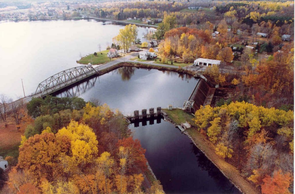
- Norwood: La presa es una estructura de gravedad de hormigón, de 188 pies de largo por 24 pies de alto con vigas de madera de 1 pie de alto. tableros de flashConfina un embalse de 350 acres. La estructura de entrada es de hormigón con rejillas de acero para basura, una sección de desnatador y tres puertas corredizas de acero motorizadas. puertasHay dos compuertas de madera, una de 2,75 m de ancho por 3,65 m de alto, y la otra de 3,65 m de alto por 3,65 m de ancho. El conducto de troncos de hormigón tiene un... Detener registro abertura de 11 pies, 2 pulgadas por 4 pies, 6 pulgadas de alto. El central eléctrica Está construida de hormigón y ladrillo y contiene una unidad generadora de 3,1 MW. La central eléctrica está integrada en la presa, por lo que no hay tramos desviados.
- East Norfolk: La presa es una estructura de gravedad de hormigón que consta de un canal de 195 pies de largo. ojiva aliviaderoUna estructura de troncos de 8,5 m y una sección adicional de aliviadero conopial de 15,2 m de ancho. La presa contiene un embalse de 54 hectáreas. La estructura de entrada de hormigón está equipada con rejillas de acero para residuos, una sección de skimmer y un conducto de hielo con tres compuertas corredizas de acero. El acero... canal artificial Tiene 9,7 metros de ancho por 420 metros de largo y forma ovalada. La presa crea un tramo desviado de aproximadamente 640 metros de largo. La central eléctrica contiene una sola unidad generadora de 4,0 MW.
- Norfolk: La presa es una estructura de hormigón, con un aliviadero de 115 metros de largo y 6 metros de alto con compuertas de 25 cm, tres compuertas de acero de 3,6 metros de ancho por 3 metros de alto en la obra de cabecera, y dos compuertas de 2,7 metros de alto por 2,7 metros de ancho. La presa contiene un embalse de 4 hectáreas. Una central eléctrica... canal Se extiende aproximadamente 1.275 pies aguas abajo de la entrada del canal y se conecta a una duela de madera de 14 pies de diámetro y 715 pies de largo. compuerta, que se transforma en una tubería forzada de acero de 4,3 metros de diámetro y 31 metros de longitud, equipada con una válvula de mariposa motorizada. La duela está protegida por dos rejillas de acero para basura y cuenta con una sección de skimmer y una compuerta de hielo de 1,8 metros de ancho por 1,8 metros de alto. Esta compuerta se utiliza para evacuar el hielo y los escombros río abajo. La presa crea un tramo desviado de aproximadamente 1124 metros de longitud. El canal de energía tiene 385 metros de longitud. La central eléctrica está construida de hormigón y ladrillo y contiene una sola unidad generadora de 4,5 MW.
- Raymondville: La presa es una estructura de gravedad de hormigón de 89 metros de ancho por 5 metros de alto, con tableros de caucho y acero de 60 centímetros de alto. La presa contiene un embalse de 20 hectáreas. Cuenta con dos desagües de estanque de 1,2 metros por 1,2 metros y un canal de agua de hormigón de 14,7 metros de ancho por 135 metros de largo con rejillas para la basura, un conducto para hielo y tres compuertas de acero para la toma de agua, cada una de 3,6 metros de ancho por 3 metros de alto. La presa crea un tramo desviado de aproximadamente 100 metros de largo. La central eléctrica está construida de hormigón, ladrillo y acero, y contiene una sola unidad generadora de 2,7 MW.
El proyecto opera en un de pasada Modo. De 2002 a aproximadamente 2007, los proyectos de desarrollo se operaron en modo pulsante. La fluctuación normal del embalse se limitó a no más de 0.5 pies en los proyectos de Norwood, East Norfolk y Raymondville, y a no más de 1.0 pies en el de Norfolk. Posteriormente, en 2006, la operación de todos los proyectos cambió de modo pulsante a modo de pasada. Este modo de operación tiene como objetivo un límite máximo normal de fluctuación de 0.2 pies por debajo de la cresta de la presa o la parte superior de los embalses. Sin embargo, se permite una fluctuación de hasta 0.5 pies en el embalse antes de que se justifique una notificación de desviación del nivel del embalse al Departamento de Conservación Ambiental del Estado de Nueva York (NYSDEC) y a la Comisión Federal Reguladora de Energía (FERC). Este modo mantiene los niveles del embalse en o cerca de la parte superior de la cresta de la presa o la parte superior de tablero de flash.
Se proporcionan caudales mínimos en cada uno de los desarrollos, los cuales se desarrollaron con base en un estudio Delphi. Los volúmenes y la periodicidad de los caudales en cada desarrollo se diseñaron para respaldar múltiples objetivos de gestión de las agencias de recursos, que priorizaron la restauración del desove e incubación de la lucioperca americana como máxima prioridad, el movimiento de peces, la restauración de la producción de invertebrados bentónicos y peces forrajeros. ribereño y humedal Producción, estética, seguridad y calidad del agua. En los tramos donde era poco posible realizar mejoras, los caudales se mantuvieron al mínimo. En los tramos donde se esperaban beneficios significativos, se establecieron caudales mayores o períodos más largos de caudales estacionales.
- Norwood: Se libera un caudal continuo de transporte de peces de 20 pies cúbicos por segundo para el paso aguas abajo;
- East Norfolk: Se mantiene una liberación de 75 cfs durante todo el año hacia el tramo de derivación a través de la sección de registro de parada cerca de la costa izquierda y la entrada.
- Norfolk: Se mantiene una descarga anual de 75 pies cúbicos por segundo (cfs) por debajo de la confluencia del canal de compuerta de basura y el tramo de derivación. Se mantiene una descarga de 55 pies cúbicos por segundo desde la sección de registro de parada de la presa cerca de la orilla derecha. cabeza Compuertas en el extremo aguas arriba del tramo de derivación. Se mantiene una segunda descarga de 20 pies cúbicos por segundo en el canal de compuerta de basura que ingresa al tramo de derivación.
- Raymondville: Se libera un caudal de transporte de peces de 20 pies cúbicos por segundo en el tramo de derivación para el paso aguas abajo. flujo base Debajo del desarrollo también se proporciona un caudal que varía según las condiciones del río (años húmedos, normales, secos o críticamente secos). Todos los caudales se vierten desde la presa cuando el desarrollo no está en funcionamiento.
Las aguas dentro del alcance del proyecto se clasifican como Clase C. Estas aguas se gestionan para alcanzar y mantener un nivel de calidad que favorezca plenamente la biota acuática, la fauna, el hábitat acuático, la natación y otras actividades recreativas de contacto primario, la navegación, la pesca y otros usos recreativos. El Departamento de Conservación Ambiental del Estado de Nueva York (NYSDEC) no ha identificado aguas contaminadas en el alcance del proyecto. El proyecto construyó e instaló voluntariamente estaciones de eliminación de especies invasoras, de acuerdo con el diseño del NYSDEC, en los embarcaderos de cada desarrollo, para mitigar la propagación de la especie invasora milenrama acuática euroasiática. Esta especie suele transportarse de un cuerpo de agua a otro en embarcaciones recreativas, kayaks y canoas.
En los desarrollos para la anguila americana se proporciona un paso aguas arriba, una catádromo Se desarrolló un plan de paso para anguilas mediante consulta con el Servicio de Pesca y Vida Silvestre de los Estados Unidos (USFWS) y el Departamento de Conservación Ambiental del Estado de Nueva York (NYSDEC). Las instalaciones del paso para anguilas consisten en estructuras de aluminio de 45 cm de ancho. canales con fondos sólidos, instalados con una pendiente máxima de 45 grados, canales de aluminio de un pie de ancho para transmitir flujos de atracción, bombas y sifones Para proporcionar atracción y flujos de escalera, placas de cubierta removibles en East Norfolk, Norfolk y Raymondville y revestimientos de sustrato en los canales. Sifón Se utilizan tuberías para suministrar caudales de atracción de 120 galones por minuto (GPM) y las bombas suministran 20 GPM a las escaleras. Las escaleras están articuladas en las secciones inferiores para evitar daños durante caudales altos, hielo y otros impactos de escombros. Las liberaciones de caudal mínimo en cada desarrollo permiten el paso aguas abajo de las especies fluviales. Las especies de peces residentes en el río incluyen un grupo diverso de peces de caza y de sartén. El Departamento de Conservación Ambiental del Estado de Nueva York (NYSDEC) gestiona el río como una pesquería mixta de agua fría y cálida. Las especies más abundantes son la lucioperca americana, la lobina de boca chica, el lucio del norte, la perca amarilla, la perca de roca, la perca de calabaza y el bagre marrón. Los depósitos de basura con una separación de 2,5 cm en los desarrollos mitigan el potencial de... arrastre.
El límite del proyecto abarca más de 2000 acres, incluyendo los embalses. Las zonas de desbordamiento de los embalses se destinan a viviendas rurales y usos industriales. Las zonas de desbordamiento del bajo río Raquette, ubicadas entre los desarrollos, se componen de tierras agrícolas y naturales sin valor ecológico significativo.
Las especies amenazadas o en peligro de extinción potencialmente presentes en las inmediaciones del proyecto incluyen el murciélago orejudo norteño, varias aves migratorias invernantes, el águila calva, el mejillón amarillo, el esturión de lago y el flox velloso, según se identificó mediante consulta con el Departamento de Conservación Ambiental del Estado de Nueva York (NYSDEC). No se ha identificado ningún hábitat crítico en el área del proyecto para las especies de aves incluidas, según lo indicado por el Servicio de Pesca y Vida Silvestre de los Estados Unidos (USFWS). Se ha determinado que las poblaciones de mejillón amarillo se encuentran en buen estado y las operaciones de pasada mitigan cualquier posible impacto del proyecto sobre la especie. De igual manera, no se prevé que las poblaciones de esturión de lago se vean afectadas negativamente debido a las operaciones de pasada del proyecto. La consulta con el NYSDEC y el USFWS detectó la presencia de flox velloso en una ubicación no revelada cerca de un desarrollo, pero se concluyó que las operaciones no afectarían a la especie.
El proyecto se construyó en 1928, pero ninguna estructura en los desarrollos cumple con los criterios para ser incluida en la lista. Registro Nacional de Lugares HistóricosAdemás, no se identificaron propiedades de importancia religiosa o cultural indígena en el área del proyecto, a pesar de la proximidad del proyecto a la reserva de la tribu St. Regis Mohawk río abajo.
El acceso público es gratuito y los recursos recreativos del proyecto incluyen:
- Norwood: transporte de canoas, rampa para botes, instalaciones para picnic y área de estacionamiento.
- East Norfolk: transporte de canoas con estacionamiento.
- Norfolk: transporte de canoas con estacionamiento.
- Raymondville: transporte de canoas, rampa para botes en la parte superior del automóvil e instalaciones para pícnic con estacionamiento.
Estado de cumplimiento
El Certificado incluye las siguientes condiciones específicas de la instalación:
Condición 1: El propietario de la instalación deberá seguir presentando informes anuales a LIHI en sus presentaciones anuales de cumplimiento, que documenten las desviaciones operativas ocurridas a lo largo del año, ya sean involuntarias o planificadas. El informe deberá presentarse simultáneamente con la declaración anual de cumplimiento.
Condición 2: El propietario de la instalación deberá proporcionar actualizaciones del estado en los informes de cumplimiento anuales sobre cualquier acuerdo relacionado con la reubicación del medidor USGS y/u otras alternativas implementadas para el monitoreo del caudal del arroyo en Raymondville.
2025: No se identificaron cambios sustanciales ni problemas de cumplimiento. El proyecto se mantiene en cumplimiento según la revisión anual. En la Condición 1, el proyecto reportó varias desviaciones menores que no se consideran infracciones de la FERC, junto con una que la FERC determinó como una infracción. En la Condición 2, el proyecto no reportó cambios en su estado.
2024: No se identificaron cambios sustanciales ni problemas de cumplimiento. El proyecto se mantiene en cumplimiento según la revisión anual. En la Condición 1, el proyecto reportó varias desviaciones menores que no se consideran infracciones de la FERC. En la Condición 2, el proyecto no reportó cambios en su estado.
2023: No se identificaron cambios sustanciales ni problemas de cumplimiento. El proyecto se mantiene en cumplimiento según la revisión anual. En la Condición 1, el proyecto reportó varias desviaciones menores que no se consideran infracciones de la FERC. En la Condición 2, el proyecto no reportó cambios en su estado.
2022: No se identificaron cambios sustanciales ni problemas de cumplimiento. El proyecto se mantiene en cumplimiento según la revisión anual. En la Condición 1, el proyecto reportó varias desviaciones menores que no se consideraron infracciones de la FERC y una desviación del caudal base en Raymondville que se consideró una infracción de la FERC. Si bien fue de muy corta duración, el proyecto implementó medidas correctivas, realizó las notificaciones pertinentes a las agencias y no se identificaron impactos adversos. En la Condición 2, el proyecto no reportó cambios en su estado.
2021: No se reportaron cambios ni problemas de cumplimiento. El proyecto se mantiene en cumplimiento según la revisión anual. En la Condición 1, el proyecto reportó varias desviaciones menores que no se consideran infracciones de la FERC. En la Condición 2, el proyecto no reportó cambios en su estado.
2020: No se reportaron cambios ni problemas de cumplimiento. El proyecto se mantiene en cumplimiento según la revisión anual. En la Condición 1, el proyecto reportó cuatro desviaciones menores que no se consideran infracciones de la FERC. En la Condición 2, el proyecto no reportó cambios en su estado.
2019: La presentación de informes anuales para el Certificado actual aún no ha entrado en vigor.
Historial de certificaciones
1 de enero de 2022: El plazo del Certificado LIHI se ha extendido de acuerdo con la Revisión 2.05 del Manual de Certificación LIHI 2.ª Edición emitido el 1 de enero de 2022. Consulte la tabla de instalaciones anterior para conocer el nuevo plazo.
7 de febrero de 2020: La decisión de recertificar el Proyecto Lower Raquette quedó firme tras el cierre del período de apelaciones el 5 de febrero de 2020, sin que se presentaran apelaciones. El plazo de certificación es del 9 de julio de 2019 al 8 de julio de 2024.
6 de enero de 2020: El Instituto de Energía Hidroeléctrica de Bajo Impacto (LIHI) ha aprobado preliminarmente la Recertificación de Bajo Impacto para el Proyecto Hidroeléctrico Lower Raquette. Esta decisión es preliminar, a la espera del plazo de apelación de 30 días. Solo quienes presentaron comentarios sobre la solicitud inicial durante el plazo de 60 días pueden presentar una apelación. Dicha apelación debe incluir una explicación de por qué el Proyecto no cumple con los criterios de LIHI. Las solicitudes de apelación pueden enviarse por correo electrónico a comments@lowimpacthydro.org Con el asunto "Proyecto Hidroeléctrico Lower Raquette", o por correo postal dirigido al Instituto de Energía Hidroeléctrica de Bajo Impacto, 329 Massachusetts Ave, Suite 6, Lexington, MA 02420. Todas las solicitudes se publicarán en el sitio web. El solicitante tendrá la oportunidad de responder, y cualquier respuesta también se publicará. Las solicitudes deben recibirse antes de las 5 p. m., hora del Este, el 5 de febrero de 2020. La solicitud completa y el informe de los revisores están disponibles a continuación. Si no se reciben solicitudes de apelación y la decisión es definitiva, el plazo de certificación del Proyecto será del 9 de julio de 2019 al 8 de julio de 2024.
13 de agosto de 2019: El Instituto de Energía Hidroeléctrica de Bajo Impacto (LIHI) ha recibido una solicitud completa para la Recertificación de Bajo Impacto del Proyecto Hidroeléctrico Lower Raquette. LIHI solicita comentarios públicos sobre esta solicitud. En concreto, nos interesa saber si considera que el Proyecto cumple con los Criterios de Certificación de Bajo Impacto de LIHI, revisados en la 2.ª edición del Manual. Por favor, revise el programa y los criterios en la versión revisada de LIHI. Manual y luego revise los materiales de solicitud del Proyecto a continuación. Comentarios que están directamente relacionados con criterios específicos de LIHI (caudales, calidad del agua, paso de peces, etc.) serán de gran ayuda, pero se tendrán en cuenta todos los comentarios. Los comentarios pueden enviarse al Instituto por correo electrónico a comments@lowimpacthydro.org con “Comentarios del Proyecto Lower Raquette” en la línea de asunto, o por correo dirigido al Low Impact Hydropower Institute, 329 Massachusetts Avenue, Suite 6, Lexington, MA 02420. Los comentarios deben recibirse antes de las 5:00 p. m., hora del Este, el 12 de octubre de 2019. Se considerarán todos los comentarios. Se publicarán en el sitio web y el solicitante tendrá la oportunidad de responder. También se publicarán todas las respuestas.
15 de mayo de 2015: El Proyecto Hidroeléctrico del Bajo Río Raquette ha sido certificado para un tercer período de certificación de bajo impacto, vigente desde el 9 de julio de 2014 hasta el 9 de julio de 2019, con las siguientes condiciones:
- Condición satisfecha en 2016. El propietario de la instalación deberá elaborar un borrador del Plan de Reducción de Desviaciones (PRD) y presentarlo a LIHI a más tardar tres meses después de la certificación del PRD por parte de LIHI. El PRD definirá enfoques proactivos de control operativo para las descargas de presas y el mantenimiento del nivel de los estanques, lo que reducirá la probabilidad de que se produzcan desviaciones operativas en el futuro. El PRD debe abordar los problemas específicos y las posibles recomendaciones identificadas en el informe del revisor. Las opciones a considerar deben incluir alarmas audibles en los centros de control y controladores lógicos programablesEl Plan de Reducción de Desastres (PRD) deberá describir las opciones consideradas, las seleccionadas y un cronograma de implementación. El personal de LIHI revisará y comentará el borrador del plan y estará disponible para asistir en el desarrollo del PRD, si se solicita. El PRD final debe ser completado y aprobado por EBH y LIHI a más tardar seis meses después de la certificación de LIHI.
- La condición continuó en la certificación 202o. El propietario de la instalación deberá presentar informes anuales a LIHI que documenten las desviaciones operativas del caudal del cauce o de los niveles del estanque ocurridas durante cada año de certificación. El informe deberá describir todas las desviaciones ocurridas, independientemente de si fueron planificadas o no intencionales, o si la FERC las considera finalmente como no violatorias de la licencia. El informe debe presentarse simultáneamente con la declaración anual de cumplimiento y el pago de la cuota anual de certificación.
Al emitir esta Certificación, el Director Ejecutivo del Instituto utilizó la autoridad delegada por la Junta Directiva de LIHI y la recomendación unánime del Comité Técnico de la Junta Directiva de LIHI resultante de una revisión completa del informe del Revisor de la Solicitud (disponible en la sección Archivos a continuación) y todos los comentarios públicos y materiales adicionales proporcionados por el Solicitante.
12 de mayo de 2014: El Instituto de Energía Hidroeléctrica de Bajo Impacto recibió una solicitud para un tercer período de certificación del Proyecto del Río Raquette. El plazo actual de la certificación vence el 9 de julio de 2014, pero para dar tiempo a los comentarios públicos y a la revisión interna, se ha extendido hasta el 30 de agosto de 2014.
15 de abril de 2010: El Proyecto del Río Raquette ha sido certificado como de bajo impacto por un segundo período de cinco años, vigente desde el 9 de julio de 2009 hasta el 9 de julio de 2014.
27 de octubre de 2004: El Proyecto del Río Raquette ha sido certificado como de bajo impacto por un período de cinco años, a partir del 9 de julio de 2004 y hasta el 9 de julio de 2009.
Archivos de certificación
Recertificación 2019
- Informe de revisión de recertificación de Lower Raquette 2019
- Solicitud de recertificación de Lower Raquette, agosto de 2019
- Carta de comentarios de la Asociación de Propietarios de Norwood Lakefront: Recertificación de Lower Raquette
Recertificación 2014
- Informe de revisión de la recertificación de Lower Raquette 2014
- Solicitud de recertificación de Lower Raquette 2014
- Carta de comentarios del Servicio de Pesca y Vida Silvestre de EE. UU.: Recertificación de Lower Raquette
- Carta de comentarios de John Omohundro: Recertificación de la raqueta inferior
Recertificación 2009
Certificación 2004
- Informe de revisión de la certificación del proyecto del río Raquette
- Solicitud de LIHI para proyectos del río Raquette
- Anexo de solicitud de certificación de proyectos del río Raquette
Documentos clave
- Licencia FERC del río Raquette 2002
- Evaluación ambiental de la FERC del río Raquette de 2001
- Certificación de calidad del agua de Lower Raquette 1998
- Certificación de calidad del agua de Lower Raquette 2006
- Acuerdo de solución del río Raquette de 1998