LIHI Certificate #156 – Piercefield Project, New York
| Project Name | Piercefield |
| LIHI Certificate No. |
156 |
| LIHI Certification Term |
April 26, 2019 – April 25, 2029 |
| Owner | Erie Boulevard Hydropower, LP, a subsidiary of Brookfield Renewable Energy Group |
| State | New York |
| Location | River Mile 88.5 on the Raquette River |
| Installed Capacity | 2.7 MW |
| Average Annual Generation | 16,520 MWh |
| Facility Type | Modified run of river |
| FERC No. | P-7387 issued 2005, expires 10/31/2035 |
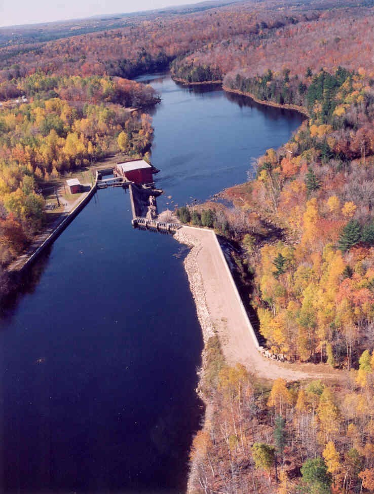
The Piercefield Project is located on the Raquette River near the Town of Piercefield in Franklin and St. Lawrence Counties in New York. The project dam and powerhouse were originally constructed in 1899 by the International Paper Company to provide mechanical power to the paper making process. The facility was converted to an electric generating station in 1926. Several other modifications took place in the early 1900s and later in the 1970s to replace timber sections of the structures with stronger concrete structures.
The Raquette River has a total drainage basin of 1,269 square miles at its mouth and originates in the Adirondack highlands at Blue Mountain Lake, Raquette Lake and Long Lake. The river flows generally north-northwest for more than 146 miles, through Potsdam, New York, and empties into the St. Lawrence River, near Massena, New York.
A total of 19 hydroelectric projects exist on the Raquette River, most of which are owned by the project owner including from upstream to downstream, Yaleville (LIHI #157), Upper Raquette (LIHI #14A), Middle Raquette (LIHI #14B), and Lower Raquette (LIHI #14C). The project itself is the southernmost and furthest upstream dam on the river.
The project includes: the dam, retaining wall, stop-log spillway, ogee spillway, bypassed reach, powerhouse, one vertical Francis turbine, and two horizontal double Francis turbines./p>
The dam is a 23-foot-high concrete and timber dam, approximately 300 feet long with a 495-foot-long retaining wall/dike on the right shoreline. A 700-foot-long retaining wall is located along the left shoreline. The spillways include a 118-foot-long stanchion type stop log spillway and a 294-foot-long, 23-foot-high ogee spillway section with an Obermeyer inflatable 2-foot-high flashboard system, and a 110-foot-long forebay retaining wall. A 550-foot-long bypassed reach is created by the dam. The powerhouse contains one vertical Francis unit and two horizontal double Francis units with a combined capacity of 2.7 MW.
The project operates in a modified run-of-river mode and impounds a 370-acre reservoir that extends 1.9 miles upstream. The project provides a minimum flow of 150 cfs in the tailrace and impoundment fluctuations are maintained within 1-foot from the top of the flashboards. This flow regime was developed in collaboration with the New York State Department of Environmental Conservation (NYSDEC), US Fish and Wildlife Service (USFWS), the Adirondack Park Agency, and New York Rivers United. The parties involved concur that this flow regime provides adequate habitat downstream and maintains a stable vegetative buffer around the reservoir. An additional 20 cfs is provided farther down in the bypassed reach to provide attraction flows away from intakes to minimize fish entrainment and to provide downstream passage.
Waters within the project reach are designated as Class C. There are no impaired waters in the project vicinity and NYSDEC has confirmed that the project continues to meet every designated use group.
Downstream waterfalls and water features create natural barriers to passage for migratory fish species at the project. The project reach supports resident fish populations of yellow perch, walleye, rock bass, smallmouth bass, lake whitefish, fallfish, and golden shiner. Walleye are particularly abundant in the project area. The 150-cfs minimum flow requirement supports fishery resources downstream of the project and the 20-cfs downstream fish bypass provides adequate passage and trashracks with 1-inch spacing mitigate potential for entrainment. This design was approved by NYSDEC and USFWS for downstream passage protection.
The project lands consist of roughly 18 acres located in the Adirondack State Park, and is governed by Part 577 of the Wild, Scenic, and Recreational Rivers Act which restricts new structure development, promotes forest management, and requires a buffer zone from the river’s edges. The project operates under a flow and water level monitoring plan which minimizes effects to the shoreline via limiting impoundment fluctuations. This ensures an adequate vegetative buffer on the shoreline and minimizes erosion.
Threatened or endangered species potentially present in the project vicinity include the Northern long-eared bat, bald eagle and spruce grouse. The project is in compliance with USFWS Rule 4(d) concerning the protection of Northern long-eared bat populations as well as the NYSDEC Conservation Plan for bald eagles. These provisions primarily dictate avoidance of tree clearing operations during specific nesting periods. NYSDEC also determined that the project does not have any impact on spruce grouse populations. Via consultation with NYSDEC in 2019, it was concluded that bald eagle populations are doing very well in New York and project operations do not pose any threat to their success.
Historic properties in the project area include the Piercefield dam and powerhouse, built in 1899 by the International Paper Company to produce newsprint. The project owner developed a historic properties management plan in consultation with the State Historic Preservation Office (SHPO) in order to identify historic properties, provide protective maintenance, and facilitate improvements. The project owner trained its operation staff to provide weekly monitoring updates on the historic properties and files annual reports with the SHPO.
Recreational resources at the project include a boat launch, canoe put-in/take-out areas, and two designated bank fishing areas. The project owner provides a 750-cfs recreational release for five hours on the last Saturday in June. Public access is provided free of charge.
Compliance Status
There are no facility-specific conditions in the current Certificate
2025: No material changes or compliance issues were identified. The project remains in compliance based on the annual review.
2024: No material changes or compliance issues were identified. The project remains in compliance based on the annual review.
2023: No material changes or compliance issues were identified. The project remains in compliance based on the annual review.
2022: No material changes or compliance issues were identified. The project remains in compliance based on the annual review.
2021: There were no reported changes or compliance issues. The project remains in compliance based on the annual review.
2020: There were no reported changes or compliance issues. The project remains in compliance based on the annual review.
2019: Annual reporting for the current Certificate has not yet taken effect.
Certification History
January 1, 2022: The LIHI Certificate term has been extended in accordance with Revision 2.05 of the LIHI 2nd Edition Certification Handbook issued January 1, 2022. Refer to the facility table above for the new term.
August 13, 2019: The decision to certify the Piercefield Hydroelectric Project is final. No appeals were received during the appeal period which closed on August 9, 2019. The new certification term for the Project is from April 26, 2019 through April 25, 2024.
July 10, 2019: The Low Impact Hydropower Institute has preliminarily approved Low Impact Certification for the Piercefield Hydroelectric Project.
This decision is preliminary pending the 30-day appeal window. Only those who commented on the initial application during the 60-day comment period are eligible to file an appeal. Such appeal needs to include an explanation as to how the Project does not meet the LIHI criteria. Appeal requests can be submitted by email to comments@lowimpacthydro.org with “Piercefield Hydroelectric Project” in the subject line, or by mail addressed to the Low Impact Hydropower Institute, 329 Massachusetts Ave, Suite 6, Lexington, MA 02420. All requests will be posted to the website. The applicant will have an opportunity to respond and any response will also be posted. Requests must be received by 5 pm Eastern time on August 9, 2019. The full application and reviewers report are available below.
If no appeal requests are received and the decision becomes final, the Certification term for the Project (pending LIHI #156) will be April 26, 2019 for a term of five (5) years, which will expire on April 25, 2024.
May 1, 2019: The Low Impact Hydropower Institute has received a complete application for Low Impact Certification of the Piercefield Hydroelectric Project. LIHI is seeking public comment on this application. Specifically, we are interested in knowing whether you think the Project meets the LIHI Low Impact Certification Criteria, as revised in the 2nd Edition Handbook. Please review the program and criteria in LIHI’s revised Handbook and then review the Project’s application materials below.
Comments that are directly tied to specific LIHI criteria (flows, water quality, fish passage, etc.) will be most helpful, but all comments will be considered. Comments may be submitted to the Institute by e-mail at comments@lowimpacthydro.org with “Piercefield Project Comments” in the subject line, or by mail addressed to the Low Impact Hydropower Institute, 329 Massachusetts Avenue, Suite 6, Lexington, MA 02420. Comments must be received on or before 5 pm Eastern time on June 30, 2019 to be considered. All comments will be posted to the web site and the applicant will have an opportunity to respond. Any response will also be posted.