LIHI Certificate #128 – Otter Creek Project, Vermont


| Project Name | Otter Creek |
| LIHI Certificate No. | 128 |
| LIHI Certificate Term |
January 7, 2021 – January 6, 2031 |
| Owner | Green Mountain Power Corporation |
| State | Vermont |
| Location | Located between river mile 21 and 64.2 on Otter Creek in west-central Vermont within Addison and Rutland Counties, near the communities of Proctor, Middlebury, and Weybridge, Vermont. |
| Installed Capacity | Total: 22.807 MW, Proctor: 10.233 MW, Beldens: 5.849 MW, Huntington Falls: 6.725 MW |
| Average Annual Generation | 60,322 MWh |
| Facility Type | Proctor: modified run-of-river Beldens: run-of-river Huntington Falls: run-of-river |
| FERC No. | P-2558 issued in 2014, expires 09/30/2054 |
The Otter Creek Project is located on Otter Creek in west-central Vermont in Addison and Rutland counties near the towns of Proctor, New Haven, and Weybridge. The project consists of three developments: Proctor, Beldens, and Huntington Falls. Otter Creek is approximately 100 miles long and flows northwesterly from the headwaters of Emerald Lake to its confluence with Lake Champlain. There are six other dams on Otter Creek. Upstream of the Proctor Development are Emerald Lake Dam, Ripley Mills Dam, and Center Rutland (FERC No. 2445). In between the Proctor and Beldens developments is the Middlebury Lower Project (LIHI #99). Downstream of the Huntington Falls development are the Weybridge Project (LIHI #98) and the Vergennes Project (LIHI #134). The project is owned by Green Mountain Power (GMP), the first energy utility certified as a B-Corporation.
The project includes three developments:
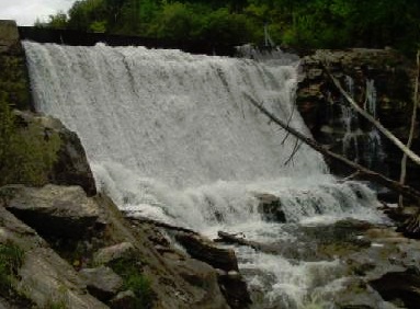
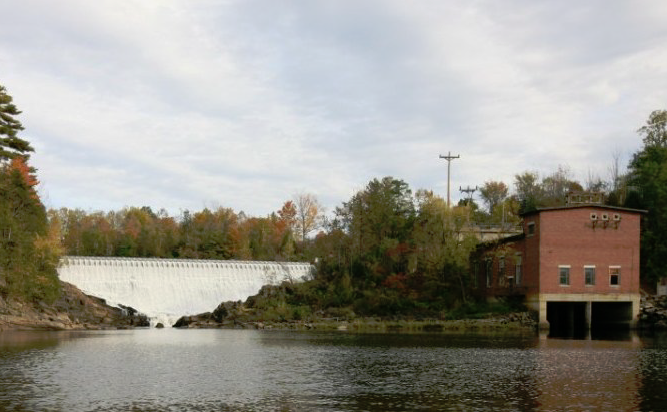
- Proctor: This development was built in 1905 and impounds a 95-acre reservoir that creates a bypassed reach known as Sutherland Falls which is 680 feet long and drops approximately 100 feet in elevation. The dam is a 128-foot-long, 13-foot-high masonry, concrete dam with a 3-foot-high inflatable flashboard system. Inflow passes through a 17-foot-deep by 45-foot-wide by 115-foot-long gated forebay intake structure that contains trashracks with 1-inch clear bar spacing, angled at 45 degrees. Two steel penstocks convey water from the forebay to the powerhouse. One penstock is 9 feet in diameter and extends 320 feet from the dam to a former surge tank footing (the surge tank no longer at the site). From the surge tank footing, the penstock continues as an 8-foot-diameter penstock for an additional 96 feet to the powerhouse. The other penstock is 7 feet in diameter and 500 feet long extending directly into the powerhouse and passes through a former surge tank structure as well. The concrete masonry powerhouse contains four Francis turbine generator units. Additionally, there is a 28-foot by 48-foot steel extension of the powerhouse, which contains a single vertical Francis turbine generator unit. Total installed capacity is 10.233 MW.
- Beldens: This development was built in 1913 and impounds a 22-acre reservoir. The dam is concrete with 2.5-foot-high wooden flashboards and is comprised of two sections on either side of a bedrock island, creating two bypass reaches about 450 feet long overall. The eastern section of the dam is 24 feet high, 57 feet long and the western section of the dam is 15 feet high and 56 feet long. There are two intake structures equipped with trashracks. The East Dam intake is equipped with a trashrack with vertical bars and 3-inch clear spacing. The West Dam intake is equipped with a trashrack with 1 1/8-inch clear spacing. Two steel penstocks convey water from the forebay to two separate powerhouses. The first penstock is steel and begins at 12 feet in diameter then bifurcates into two 10-foot diameter sections approximately 30 feet long which lead to the original powerhouse (Powerhouse 1). The other concrete penstock is 12 feet in diameter and 45 feet long leading to a newer powerhouse (powerhouse 2). Powerhouse 1 is a concrete and masonry structure that houses two horizontal Francis turbine generator units. Powerhouse 2 is a concrete structure that houses one horizontal Kaplan turbine generator unit. Total installed capacity is 5.849 MW. The tailrace extends approximately 550 feet downstream to the Huntington Falls impoundment.
- Huntington Falls: This development was built in 1910 and impounds a 23-acre reservoir that creates a short 250-foot-long bypassed reach. The dam is composed of a 187-foot-long, 31-foot-high concrete dam with a 2.5-foot-high inflatable flashboard system. Inflow from the impoundment passes through two intakes and water is conveyed through three penstocks that lead to two powerhouses. Intake racks at Unit 1 and 2 are equipped with trashracks having bar spacing of 1.125 inches. The intake at unit 3 is equipped with a trashrack with 2-inch clear bar spacing orientated parallel to river flow. Two steel penstocks are 10 feet in diameter and 30 feet long which lead to the original powerhouse (Powerhouse 1). The third penstock is concrete and 12 feet in diameter and 75 feet long that leads to a concrete powerhouse (Powerhouse 2). Powerhouse 1 is the original brick powerhouse and contains two horizontal Francis turbine generating units. Powerhouse 2 is made of concrete and contains one horizontal Kaplan turbine-generator unit. Total installed capacity is 6.725 MW.
The project operates in a run-of-river mode at Proctor with the impoundment level maintained at or near the top of the flashboards from July 1 – April 30 when inflow is less than 200 cfs, and from May 1 – June 30 when inflow is less than 400 cfs. At all other times, the development operates in a peaking mode with the impoundment maintained within 1.5 feet of the top of the flashboards. Beldens and Huntington Falls operate in true run-of-river mode. Flows at the three developments vary based on season and river inflow. Maximum and minimum flows were developed from an instream flow study in consultation with Vermont Agency of Natural Resources (VANR) and dictate at what point peaking operations are allowed. Minimum flows in the bypassed reaches are provided to ensure adequate aquatic habitat – Proctor provides 60 cfs, Beldens provides 35 cfs, and Huntington Falls provides 66 cfs.
Waters within the project reach are designated as Class B, suitable for aquatic biota, wildlife, and habitat, primary contact recreation, water supply, and agricultural uses. Water downstream of the Proctor and Huntington Falls developments is classified as a warm-water fishery and the area between Beldens and Huntington Falls is considered a cold-water fishery. Water quality concerns in the river are elevated levels of E. coli and phosphorus pollution. VANR determined the project is not contributing to these impairments which are likely due to agricultural run-off and effluent from wastewater treatment facilities.
Historically, Otter Creek has not supported any natural populations of anadromous or catadromous fish species. Additionally, a natural set of falls downstream of the Huntington Falls development would likely prevent any upstream migration. The most prominent resident fish species in the project area include brown trout, brook trout, rainbow trout, blacknose dace, longnose dace, bluntnose minnow, fathead minnow, and spottail shiner. VANR stocks the trout species all through Otter Creek. The bypass minimum flows provide a downstream route of passage and trashracks installed at each development reduce the potential for impingement and entrainment.
The project lands consist of 513 acres, 60 acres, and 51 acres at the Proctor, Beldens, and Huntington Falls developments, respectively. There are no lands of ecological significance. Most of the project shorelines consist of bedrock and run-of-river operations have minimal impact on the shoreline. Proctor is located in a deciduous and hardwood mixed forest with wetlands and agricultural land nearby. Beldens is surround by mixed hardwood, coniferous stands, deciduous scrub habitat, small wetlands, residential areas, and agricultural lands. Huntington Falls is similarly located. These lands are not expected to be impacted by the project due to the run-of-river operations.
Threatened or endangered species potentially present in the project vicinity include Indiana bat, Northern long-eared bat, bald eagle, Eastern whip-poor-will, rusty blackbird, several plant species, and four species of freshwater mussels – fluted shell, pink heelsplitter, black sandshell, and giant floater. No critical habitat exists in the project area for the bat species though it is possible that they may feed within the project boundary. The project maintains a flow monitoring and management plan to minimize impacts to mussels during impoundment drawdowns, and a terrestrial monitoring and management plan minimizes operational impacts to terrestrial species.
Cultural resources in the project area include the three developments, which are eligible for listing on the National Register of Historic Places. Several archaeological and Euro-American sites were identified at each of the project developments, including several eligible for listing on the National Register. The project maintains a historic properties management plan and annual monitoring of these sites is conducted. Run-of-river operations minimize potential impacts to the sites. This plan was developed in consultation with the Vermont Division for Historic Preservation.
Recreational resources at the project include shoreline access for angling, carry-in boating, portage trails, picnicking facilities, viewing areas, and interpretive signage. Public access is provided free of charge at each development.
Compliance Status
There are no facility-specific conditions in the current Certificate.
2025: No material changes or compliance issues were identified. The project remains in compliance based on the annual review.
2024: No material changes or compliance issues were identified. The project remains in compliance based on the annual review.
2023: No material changes or compliance issues were identified. The project remains in compliance based on the annual review.
2022: No material changes or compliance issues were identified. The project remains in compliance based on the annual review.
2021: There were no reported changes or compliance issues. The project remains in compliance based on the annual review. The project reported filing with FERC of a revised terrestrial monitoring plan for needed tree clearing that considers bat roost trees
Certification History
January 1, 2022: The LIHI Certificate term has been extended in accordance with Revision 2.05 of the LIHI 2nd Edition Certification Handbook issued January 1, 2022. Refer to the facility table above for the new term.
September 7, 2021: The Low Impact Hydropower Institute has issued a final decision on the recertification of the Otter Creek Project located on Otter Creek in Vermont. The 30-day appeal window closed on September 2, 2021 and no appeals were filed. Therefore, the decision to certify the project is now final. The certificate term is January 7, 2021 through January 6, 2026.
August 3, 2021: The Low Impact Hydropower Institute (LIHI) has preliminarily approved the Otter Creek Project for a 5-year term of Low Impact Certification. This decision is preliminary pending the 30-day appeal window. Only those who commented on the initial application during the 60-day comment period are eligible to file an appeal. Such appeal needs to include an explanation as to how the Project does not meet the LIHI criteria. Appeal requests can be submitted by email to comments@lowimpacthydro.org with “Otter Creek Project” in the subject line, or by mail addressed to the Low Impact Hydropower Institute, 1167 Massachusetts Ave, Office 407, Arlington, MA 02476. All requests will be posted to the website. The applicant will have an opportunity to respond and any response will also be posted. Requests must be received by 5 pm Eastern time on September 2, 2021. The full application and reviewer’s report are available below. If no appeal requests are received and the decision becomes final, the Certification term for the Project will be January 7, 2021 through January 6, 2026.
May 21, 2021: The Low Impact Hydropower Institute (LIHI) has received a complete recertification application from Green Mountain Power Corporation for the Otter Creek Project located on Otter Creek in Vermont. The complete application can be found below. LIHI is seeking comment on this application. Comments that are directly tied to specific LIHI criteria (flows, water quality, fish passage, etc.) will be most helpful, but all comments will be considered. Comments may be submitted to LIHI by e-mail at comments@lowimpacthydro.org with “Otter Creek Project Comments” in the subject line, or by mail addressed to the Low Impact Hydropower Institute, 1167 Massachusetts Avenue, Office 407, Arlington, MA 02476. Comments must be received at the Institute on or before 5 pm Eastern time on July 20, 2021 to be considered. All comments will be posted to the web site and the applicant will have an opportunity to respond. Any response will also be posted.
August 22, 2016 – LIHI Executive Director Michael J. Sale has issued a Certification Decision that the Otter Creek Hydroelectric Project (FERC No. P-2558) satisfies the LIHI Certification Criteria. This certification decision is based on a unanimous vote of the Governing Board members present at the June 21, 2016, Technical Committee meeting. A Preliminary Decision was announced on July 11, 2016, and a 30-day appeal period was open until August 13, 2016. No requests for appeal were received. This Certification Decision includes two facility-specific conditions, as follows:
- Condition satisfied in 2017. Condition 1. The owner shall complete construction of the new gate for minimum flow releases at Huntington Falls and fully implement the release of the 66-cfs minimum flow required at that facility. The owner shall send LIHI a letter report no later than December 31, 2016, describing the status of this implementation, and if it has not yet been completed, define and commit to remediation measures that will ensure it is completed as soon as possible.
- Condition satisfied in 2017. Condition 2. The owner shall complete all elements of the recreational plan at Huntington Falls, including the acquisition of necessary easements, and send LIHI a letter report no later than December 31, 2016 confirming that all elements have been completed. If there are any part of the Recreation Plan unfinished at that time, the owner shall explain the reasons why and actions planned to complete them.
The effective certification date for the Otter Creek Project is January 7, 2016 for a five (5) year term, which will expire on January 7, 2021.
January 8, 2016 – On January 7, 2016, the Low Impact Hydropower Institute (LIHI) received a complete application from Kleinschmidt Associates, on behalf of the Green Mountain Power Corporation, for the Low Impact Certification of the Otter Creek Project, FERC P-2558, located on Otter Creek in west-central Vermont within Addison and Rutland counties, near the communities of Proctor, Middlebury, and Weybridge, Vermont. LIHI is seeking public comment on this application. Specifically, we are interested in knowing whether you think the Otter Creek Project meets the LIHI Low Impact Certification Criteria. Please review the program and criteria in LIHI’s revised Handbook and then review the Project’s application materials posted below. Comments that are directly tied to specific LIHI criteria (flows, water quality, fish passage, etc.) will be most helpful, but all comments will be considered. Comments may be submitted to the Institute by e-mail at comments@lowimpacthydro.org with “Otter Creek Project Comments” in the subject line, or by mail addressed to the Low Impact Hydropower Institute, PO Box 194, Harrington Park, New Jersey 07640. Comments must be received at the Institute on or before 5 pm Eastern time on March 8, 2016 to be considered. All comments will be posted to the web site and the applicant will have an opportunity to respond. Any response will also be posted.