LIHI Certificate #107 - Carver Falls Project, Vermont
| Project Name | Carver Falls |
| LIHI Certificate No. | 107 |
| LIHI Certificate Term |
December 4, 2017 – December 3, 2027 |
| Owner | Green Mountain Power Corporation |
| State | Vermont |
| Location | Located in the Towns of Fair Haven and West Haven, Rutland County, Vermont, and in the Town of Hampton, Washington County, New York, at river mile 3.8 on the Poultney River. |
| Installed Capacity | 2.251 MW |
| Average Annual Generation | 6,578 MWH (5 year average) |
| Facility Type | Run-of-river |
| FERC No. | P-11475 issued in 2009, expires 01/31/2039 |
The Carver Falls Project is located in the Towns of Fair Haven and West Haven, in Rutland County, Vermont and in the Town of Hampton, in Washington County, New York on the Poultney River. The river forms a portion of the state border between Vermont and New York and drains into the southern end of Lake Champlain.
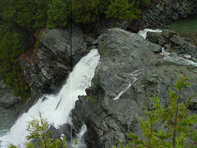
Carver Falls is the highest major falls in Vermont and contains two falls at the head of a limestone gorge. The falls have been altered by hydropower development since 1894. For 100 years before that date, they were harnessed to drive mill operations. The river above the falls lies in a ravine 100 feet deep. Below the falls, the ravine is 200 feet deep. A cave in a limestone cliff above the ravine is located about one mile below the falls. The project is owned by Green Mountain Power (GMP), the first energy utility certified as a B-Corporation.
The project includes: a dam, two spillways, penstock, powerhouse, two turbines, and a bypassed reach.
The dam is located at the top of the 80-foot drop of Carver Falls, with one abutment on the Vermont shore and the other abutment on the New York shore. The powerhouse, several hundred feet downstream of the falls, is on the New York side of the river. The dam is made of concrete and stone masonry, 514-feet-long, with two spillway sections. The northern spillway is 110-feet-long and topped with 6-foot flashboards. The southern spillway is 150-feet-long and topped with 1.5-foot flashboards. The steel penstock is 220-feet-long and 7-feet in diameter. It bifurcates into two 132-foot-long, 3 to 4-foot diameter penstocks. Two steel surge tanks are located approximately 20-feet below the point of bifurcation, one for each penstock. A butterfly valve is located in the 4-foot penstock below the surge tank. Both surge tanks are 44-feet-high and have respective diameters of 72-inches and 48-inches. The powerhouse contains two turbine generating units with a total installed capacity of 2.251 MW. Project power is transmitted through a 275-foot-long, 2.4-kilovolt transmission line connected to the regional grid. The bypass reach is 700-feet-long and includes the bedrock gorge occupied by the falls and the plunge pool at its base. It also includes immediately adjoining areas on the left bank of the river that are presently occupied by the electrical substation and other Project facilities.
The project operates in a run-of-river mode and impounds a 10-acre reservoir. The project provides a 50-cfs minimum bypass flow from April 1 – May 15 and otherwise provides 18.5 cfs for minimum bypass flow. This flow regime was developed in consultation with the New York State Department of Environmental Conservation (NYSDEC) and the Vermont Agency of Natural Resources (VANR). Monitoring gauges at the site help ensure run-of-river operations and allow for remote adjustments as well as maintaining hourly records of project data.
Waters within the project reach are designated Class B and impaired due to elevated mercury in walleye populations and water chestnut presence, an invasive species. Class B waters are managed for aquatic habitat, aesthetics, public water supply, and primary contact recreation. Consultation with VANR concluded that the project is not contributing to water quality limitations. The Lower Poultney River is one of four Outstanding Resource Waters (ORW) in Vermont. Based on this designation, VANR developed a management plan for the Lower Poultney River that established the following goal: “For that portion of the Lower Poultney River within Vermont borders, the State will seek to manage certain activities affecting the water quality, flows, course, current, and cross-section of the Lower Poultney River to preserve and enhance the exceptional natural, cultural, scenic, and recreational values of the river and river corridor.”
Historically, the waterfall that the project is situated on acts as a natural barrier to upstream fish passage. However, VANR has noted that American eel have been able to ascend the falls and can be found upstream of the project. United States Fish and Wildlife Service is actively engaged in an American eel restoration project in the Lake Champlain basin, but has yet to prescribe passage measures in the Lake Champlain tributaries. The downstream reach of the project, a warm-water fishery, is an important spawning area for walleye and has historically supported American eel populations. The upstream reach of the project is host to a cold-water fishery. Resident species would not thrive in the downstream reach of the river. Trashracks with 1.75-inch spacing and a low intake velocity mitigate entrainment.
The project lands consist of just under 100 acres. Both the upstream and downstream reaches are heavily forested and include a broader corridor with floodplain forest, wetlands with natural riparian vegetation, an unbroken wildlife migration corridor, and a high degree of biodiversity. Project operations do not interfere with VANR’s ORW management plan and the project supports one of the longest segments of natural stream corridor in Vermont.
Threatened or endangered species potentially present in the project vicinity include the Indiana Bat, Northern Long-eared Bat, Green Dragon, Meadow Horsetail, Eastern Sand Darter, Channel Darter, Cylindrical Papershell Mussel, Pocketbook Mussel, Fluted-Shell Mussel, Fragile Papershell, Black Sandshell, Pink Heelsplitter, and Giant Floater Mussel. In consultation with NYSDEC and VANR, the primary mitigation strategy for the protection of the listed species is for the project to continue its run-of-river operations. The main concern for listed bat species is tree-clearing activities. The project must consult with appropriate agencies before performing any activities that have the potential for habitat disruption.
Historic properties and cultural resources in the project vicinity include several archaeological sites, the dam, and appurtenant structures. The project operates under a historic properties management plan which includes procedures for staffing and training, consultation, treatment measures, and discovery of cultural resources/human graves or remains. This plan was developed in consultation with the Vermont Division for Historic Preservation and the New York State Historic Preservation Office.
Recreational resources at the project include picnic areas, a viewing platform for the falls, canoe portage route, and hiking trails. Public access is provided free of charge.
Compliance Status
The Certificate includes the following facility-specific conditions:
Condition partially satisfied in 2020. Condition 1: The facility Owner shall consult with Vermont DEC regarding run-of-river operations, identify any refinements needed to assure run-of-river operations are consistently maintained, and submit the results including agency comments and any operational refinements made in the first annual compliance submittal after Certification.
This portion remains active: Thereafter, the facility owner shall include a summary of any refinements made in annual compliance submittals to LIHI.
Condition 2: During the term of this certification, should a resource agency initiate consultation regarding passage or protection measures for migratory fish species, the facility Owner shall notify LIHI within 60 days, provide LIHI with a copy of the request, and the applicant’s response. The facility Owner shall summarize the status of any fish passage measures planned or being implemented in annual compliance submittals to LIHI.
2025: No material changes or compliance issues were identified. The project remains in compliance based on the annual review. For Condition 1, the project reported no additional operational refinements. For Condition 2, the project reported no activity.
2024: No material changes or compliance issues were identified. The project remains in compliance based on the annual review. For Condition 1, the project reported no additional operational refinements. For Condition 2, the project reported no activity.
2023: No material changes or compliance issues were identified. The project remains in compliance based on the annual review. For Condition 1, the project reported no additional operational refinements. For Condition 2, the project reported no activity.
2022: No material changes or compliance issues were identified. The project remains in compliance based on the annual review. For Condition 1, the project reported ongoing consultation with VDEC but no additional operational refinements. For Condition 2, the project reported no activity.
2021: There were no reported changes or compliance issues. The project remains in compliance based on the annual review. For Condition 1, the project reported ongoing consultation with VDEC but no additional operational refinements. For Condition 2, the project reported no activity.
2020: There were no reported changes or compliance issues. The project remains in compliance based on the annual review. For Condition 1, the project reported submittal of operations data to VDEC, thus partially satisfying the condition. For Condition 2, the project reported no activity.
2019: There were no reported changes or compliance issues. The project remains in compliance based on the annual review. For Condition 1, the project reported compiling operations data for upcoming submittal to VDEC. For Condition 2, the project reported no activity.
2018: Annual reporting for the current Certificate has not yet taken effect.
Certification History
January 1, 2022: The LIHI Certificate term has been extended in accordance with Revision 2.05 of the LIHI 2nd Edition Certification Handbook issued January 1, 2022. Refer to the facility table above for the new term.
January 18, 2019: The decision to recertify the Carver Falls Hydroelectric Project is final. No appeals were received during the appeal period which closed on January 17, 2019. The new certification term for the Project is from December 4, 2017 through December 3, 2022.
December 18, 2018: On December 14, 2018, the Low Impact Hydropower Institute (LIHI) preliminarily approved the Carver Falls Hydroelectric Project for a new 5-year term of Low Impact Certification. This decision is preliminary pending the 30-day appeal window. Only those who commented on the initial application during the 60-day comment period are eligible to file an appeal. Such appeal needs to include an explanation as to how the Project does not meet the LIHI criteria. Appeal requests can be submitted by email to comments@lowimpacthydro.org with “Carver Falls Hydroelectric Project” in the subject line, or by mail addressed to the Low Impact Hydropower Institute, 329 Massachusetts Ave, Suite 2, Lexington, MA 02420. All requests will be posted to the website. The applicant will have an opportunity to respond and any response will also be posted. Requests must be received by 5 pm Eastern time on January 17, 2019. The full application and reviewers report are available below. If no appeal requests are received and the decision becomes final, the Certification term for the Project will be December 4, 2017 through December 3, 2022.
November 12, 2018: The Carver Falls Hydroelectric project has been granted another extension of the current certificate term. The new expiration date is March 31, 2019.
October 9, 2018: The Low Impact Hydropower Institute has received a complete application for a new term of Low Impact Certification for the Carver Falls Hydroelectric Project (LIHI # 107). The Project is located in the towns of Fair Haven and West Haven, Rutland County, Vermont, and in the town of Hampton, Washington County, New York, at river mile 3.8 on the Poultney River. LIHI is seeking public comment on this application. Specifically, we are interested in knowing whether you think the Project meets the LIHI Low Impact Certification Criteria, as revised in the 2nd Edition Handbook. Please review the program and criteria in LIHI’s revised Handbook and then review the Project’s 2018 application materials below. Comments that are directly tied to specific LIHI criteria (flows, water quality, fish passage, etc.) will be most helpful, but all comments will be considered. Comments may be submitted by e-mail at comments@lowimpacthydro.org with “Carver Falls Project Comments” in the subject line, or by mail addressed to the Low Impact Hydropower Institute, 329 Massachusetts Avenue, Suite 2, Lexington, MA 02420. Comments must be received at the Institute on or before 5 pm Eastern time on December 8, 2018 to be considered. All comments will be posted to the web site. The applicant will have an opportunity to respond and any response will also be posted.
June 11, 2018: The Carver Falls Hydroelectric project has been granted an extension of the current certificate term. The new expiration date is December 31, 2018.
November 3, 2017: The Carver Falls Hydroelectric project has been granted an extension of the current certificate term. The new expiration date is March 31, 2018.
May 28, 2013: The Carver Falls Hydroelectric Project has been certified as low impact for a five year term, effective December 4, 2012 and expiring December 4, 2017.
February 4, 2013: Public comment period on application has closed.
December 4, 2012: Green Mountain Power has submitted an application for the certification of the Carver Falls project. The application was posted and public comment period was opened.
Certification Files
2018 Recertification
2012 Certification
- Carver Falls Certification Review Report
- Carver Falls Certification Questionnaire
- Application Appendix – Resource Agencies
- Application Appendix – Project Description
- Carver Falls Historic Documents
- Carver Falls Operations Plan and Min Flow Documents
- Carver Falls Poultney River Reserve Area Map
- Carver Falls Recreation Documents