LIHI Certificate #206 - Center Rutland Project, Vermont
| Project Name | Center Rutland |
| LIHI Certificate No. |
206 |
| LIHI Certificate Term |
September 30, 2025 -September 29, 2035 |
| Owner | Green Mountain Power Corp. |
| State | Vermont |
| Location | River Mile 71 on Otter Creek |
| Installed Capacity | 0.275 MW |
| Average Annual Generation | 541 MWh |
| Facility Type | Run-of-river |
| FERC No. | P-2445 issued December 26, 2024; expires 11/30/2064 |
The Center Rutland Hydroelectric Project is located on Otter Creek in the Town of Rutland (adjacent to the City of Rutland) in Rutland County, Vermont. The Project is located at river mile 71. Several other dams are located on the river including downstream, Otter Creek Project, LIHI #128, and well downstream, Middlebury Lower, LIHI #99, Weybridge, LIHI #98, and Vergennes, LIHI #134.
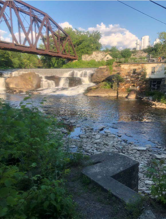
Originally built in 1850 and reconstructed in 1928, the dam is a 190-foot-long concrete and stone masonry gravity structure composed of a 16-foot-long non-overflow section and a 174-foot-long spillway, and a 16-foot-long non overflow section. The impoundment has a surface area of 10.97 acres with no usable storage capacity at the normal water surface elevation of 505.05 feet National Geodetic Vertical Datum of 1929 (NGVD 29). The dam creates a short, 250-foot-long bypassed reach which includes a bedrock falls with little aquatic habitat value and a deep pool at the downstream end of the bedrock falls which is backwatered and hydraulically connected to the tailrace at all flows of 40 cfs or higher.
A small forebay and a concrete and marble masonry intake conveys water to a 6-foot-diameter, 75-foot-long steel penstock leading to the 40-foot-long, 33-foot-wide stone and marble masonry powerhouse. The powerhouse contains one horizontal-shaft turbine driving a 0.275 MW generator. Other facility infrastructure includes a substation; an approximate 80-foot-long, 12.47-kilovolt transmission line; a 0.35-mile-long fiber-optic cable to provide smart grid communications to the project; and appurtenant equipment and facilities. Although sockets for flashboard pins exist along the crest of the concrete spillway, the wooden flashboards are not currently installed and have not been in place since 2012.
The project operates in a run-of-river mode where outflow approximates inflow and managed in accordance with a Flow Management and Monitoring Plan. The bypassed reach minimum flow is 80 cfs or inflow, whichever is less, from June 1 to October 15, and 60 cfs or inflow, whichever is less, from October 16 to May 31. These flow levels exceed the Vermont Agency of Natural Resources (VANR) recommendation.
Waters in the project area are classified as Class B(2) cold water fish habitat, suitable for the designated uses of aquatic biota, wildlife, and aquatic habitat; aesthetics; public water supply; irrigation of crops and other agricultural uses; swimming and other primary contact recreation; and boating, fishing, and other recreational uses. The project area is not listed as impaired by VANR and water quality monitoring indicated that the project does not adversely impact water quality.
Otter Creek supports cold and warm water fish species and currently does not have any diadromous fish species present within Project waters; however, the Project is within the historic range of American Eel and there are provisions for American Eel passage plans within 1 year of upstream eel passage measures being implemented at the Otter Creek Hydroelectric Project (FERC No. 2558) located immediately downstream. Resident species include typical cold and warmwater species. The trashracks have 9/16-inch clear bar spacing, which protect fish from becoming entrained. Approach velocity at the intake is less than 1 foot per second (0.70 fps) during full generation which substantially reduces the risk of impingement and entrainment because fish can swim away from the intake.
The project is located in an industrialized portion of the Otter Creek watershed and has a limited shoreline within the impoundment. Run-of-river operations limit the potential for shoreline erosion. Project non-water lands are limited to about 1/4 acre around the project structures.
Threatened and endangered species that may be present include northern long-eared bat and the proposed-for-listing tri-colored bat, but there are no known winter hibernacula or summer maternity roost sites near the project. The proposed-for-listing monarch butterfly and the protected bald eagle may also be present. State-listed mussel species found in the impoundment include the creek heelsplitter (Lasmigona compressa) and creeper (Strophitus undulatus). Since the project operates in a run-of-river mode, normal operations are not likely expected to impact the mussel species. If the impoundment needs to be drawn down, the owners would consult with VANR prior to any planned drawdowns. Given the small land footprint of 3.4 acres and lack of need for tree cutting or non-routine vegetation management, it is unlikely that the project impacts protected species.
The entire Center Rutland hydroelectric complex has been previously documented in a National Register of Historic Places registration form for the Center Rutland Hydroelectric Station Historic District (District). The nomination was never submitted to the National Register, but was kept on file with at the Vermont Department of Historic Preservation (VDHP). The district encompasses the generating station, Mead Falls, and surrounding buildings. Native American artifacts were also discovered. The project operates under a Historic Properties Management Plan which requires consultation with the VDHP and Tribes prior to conducting certain activities in order to minimize potential effects on cultural and tribal resources. The FERC license also requires the owner to design and install a cultural heritage information kiosk for the Town of Rutland, to be located at the Town’s non-project pocket park.
The project is developing a Recreation Management Plan as part of the new FERC license. Current recreational amenities at the project include informal public access to Otter Creek just below the Project tailwater on the north bank, consisting of a dirt footpath wide enough for canoe transport with informal parking adjacent to the path. Anglers utilize the informal access point on the north bank and access the south bank downstream of the dam, off of Simons Avenue. Due to the historic use of this area, the Town of Rutland began working with the owner in 2018 to discuss collaborative development of a “pocket park” that would be located within this informally utilized area. Public access is provided free of charge.
Compliance Status
The Certificate includes the following facility-specific conditions:
- Condition 1: Upon FERC approval of the HPMP required under Article 409, the Facility Owner shall provide LIHI with a copy of the approved HPMP, documentation of consultation with VDHP and affected Tribal Nations, and a brief summary of its implementation status. Updates on HPMP implementation and any consultation with VDHP and Tribal Nations during ground-disturbing work shall also be provided in annual compliance submittals to LIHI.
- Condition 2: Following FERC approval of the Recreation Monitoring Plan required under Article 407, the Facility Owner shall file the approved plan with LIHI. Annual compliance submittals to LIHI shall summarize recreational use, kiosk development coordination with the Town of Rutland, and any changes in public access conditions.
2025: Annual reporting for the current certificate has not yet taken effect.
Certification History
January 6, 2026: The Low Impact Hydropower Institute has issued a final decision on the certification of the Center Rutland Hydroelectric Project. No appeals were received during the appeal period which closed on January 4, 2026. The 10-year certification term is September 30, 2025 through September 29, 2035.
December 5, 2025: The Low Impact Hydropower Institute (LIHI) has preliminarily approved Low Impact Certification for the Center Rutland Hydroelectric Project, (pending LIHI #206). The full application and reviewer’s report are available below.
This decision is preliminary pending the 30-day appeal window. Only those who commented on the initial applications during the 60-day comment period are eligible to file an appeal. Such appeal needs to include an explanation as to how the Projects do not meet the LIHI criteria. Appeal requests can be submitted by email to comments@lowimpacthydro.org with “Center Rutland Project” in the subject line, or by mail addressed to the Low Impact Hydropower Institute, 68 Harrison Ave Ste 605, PMB 113938 Boston, Massachusetts 02111-1929. All requests will be posted to the website. The applicant will have an opportunity to respond and any response will also be posted. Requests must be received by 5 pm Eastern time on January 4, 2026. If no appeal requests are received the certification term will be September 30, 2025 through September 29, 2035.
September 30, 2025: The Low Impact Hydropower Institute has received a complete application for Low Impact Certification of the Center Rutland Hydroelectric Project. LIHI is seeking public comment on this application. Specifically, we are interested in knowing whether you think the Project meets the LIHI Low Impact Certification Criteria, as revised in the 2nd Edition Handbook in effect at the time of initial application. Please review the program and criteria in LIHI’s Handbook Revision 2.06 and then review the Project’s application materials below.
Comments that are directly tied to specific LIHI criteria (flows, water quality, fish passage, etc.) will be most helpful, but all comments will be considered. Comments may be submitted to the Institute by e-mail at comments@lowimpacthydro.org with “Center Rutland Project Comments” in the subject line, or by mail addressed to the Low Impact Hydropower Institute, 68 Harrison Ave Ste 605, PMB 113938 Boston, Massachusetts 02111-1929. Comments must be received on or before 5 pm Eastern time on November 28, 2025 to be considered. All comments will be posted to the web site and the applicant will have an opportunity to respond. Any response will also be posted.
Certification Files
2025 Application
- Center Rutland Review Report 2025
- Center Rutland Certification Application 2025
- Comment Letter Nulhegan Band of the Coosuk – Abenaki Nation
- Comment Letter Elnu Abenaki