LIHI Certificate #196 - Rollinsford Project, New Hampshire/Maine
| Project Name | Rollinsford |
| LIHI Certificate No. | #196 |
| LIHI Certificate Term | December 30, 2022 – December 29, 2032 |
| Owner | Town of Rollinsford, NH (operated by Green Mountain Power Corporation) |
| State | New Hampshire and Maine |
| Location | River Mile 0.9 on the Salmon Falls River |
| Installed Capacity | 1.5 MW |
| Average Annual Generation | 5,873 MWh |
| Facility Type | Run of river |
| FERC No. | P-3777, issued in 2022, expiring 06/01/2062 |
The Rollinsford Project is located on the Salmon Falls River in the Town of Rollinsford, Strafford County, New Hampshire, and the Town of South Berwick, York County, Maine. Most of the Project’s infrastructure including the intake, penstocks, and powerhouse are in Rollinsford, NH with the left abutment of the dam located in South Berwick, ME. The project dam was constructed in 1910 with the addition of the penstock in 1928. The hydropower components of the project were installed in 1983.
The project is the second dam on the Salmon Falls River, preceded only by the South Berwick Project (LIHI #195). Several miles downstream of the South Berwick dam, the Salmon Falls River joins the Cocheco River to form the confluence of the Piscataqua River near Dover, NH. Upstream of the Rollinsford Project, there were historically 24 dams, but some have been removed, breached, or are in ruins. Today, there are 15 dams on the Salmon Falls River, seven of which are used for hydropower generation including Lower Great Falls (LIHI #202) and South Milton (LIHI #100). The other dams are used for flood control, water supply, and recreation.
The project includes:
- a 19-foot-high, 317-foot-long concrete gravity dam consisting of a 12-foot-long left abutment, a 247-foot-long spillway section, a 22-foot-long right abutment, and a 36-foot-long gated section containing five vertical lift gates, with a crest elevation of approximately 70 feet above mean sea level (msl) and 15-inch-high flashboards;
- an integral 247-foot-long spillway section with a flood discharge capacity of 17,300 cubic feet per second (cfs);
- an impoundment with a gross volume of 456 acre-feet and a surface area of 84 acres at the normal pond, with negligible useable storage volume;
- a concrete reinforced intake structure on the left (eastern) abutment of the dam measuring approximately 52 feet wide by 82 feet long;
- five manually operated vertical lift gates located at the entrance to the intake headworks each measuring approximately 5.5 feet high and 5.5 feet wide. Two of the gates are operated with Rodney Hunt crank actuators, and the remaining three gates are operated with Rodney Hunt handwheel actuators;
- trashracks with a 2.5-inch clear bar spacing and measuring 17.6 feet high by 22.8 feet wide;
- a concrete penstock measuring 10 square feet by 600 feet long, extending from the intake headworks structure to the forebay at the powerhouse;
- a forebay measuring approximately 40 feet wide by 30 feet long constructed of reinforced concrete with a crest elevation of 73.0 feet msl;
- a 38-foot-long by 60-foot-wide brick masonry powerhouse;
- two identical vertical 750-kilowatt (kW) Siemens Allis synchronous generators each with an output voltage of 4,160 volts and two identical vertical James Leffel Co. Type “Z” Francis turbines, each having a rated output of 1,000 horsepower (hp) and operating at 360 revolutions per minute (rpm) at a rated flow of 228 cubic feet per second (cfs) and an average head of 45 feet;
- a 680-foot-long bypass reach between the dam and the tailrace; and
- appurtenant facilities.
The project operates in run-of-river mode. A minimum bypass flow of 35 cfs is provided through a notch in the flashboards. To ensure run-of-river operations, a pressure transducer relays impoundment water level information to a programmable logic controller which adjusts operations according to changes in river flows. This provides a steady impoundment level and ensures natural river flows to support and protect aquatic and riparian habitat. This flow regime was developed in consultation with New Hampshire Department of Environmental Services (NHDES) and Maine Department of Environmental Protection (MDEP).
Waters within the project reach are designated as Class B in New Hampshire and Class C in Maine. New Hampshire Class B water bodies are considered acceptable for fishing, swimming, and other recreational purposes, and after treatment, are potential water supplies. In Maine, Class C waters must ensure suitability for designated uses of drinking water, fishing, agriculture, recreation, industrial processes, cooling water, hydroelectric power generation, navigation, and habitat for fish and other aquatic life. The river is listed as impaired for pH and non-native aquatic plants by NHDES and E. coli, ammonia, eutrophication, dissolved oxygen, and biochemical oxygen demand by MDEP. Monitoring to determine further mitigation action is ongoing and will be completed in 2024.
Diadromous fish historically present in the Salmon Falls River include American shad, American eel, and river herring (blueback herring and alewife). Atlantic salmon were also present up until around 1750 as upstream dams, overfishing, and sawdust pollution disrupted these runs until salmon no longer returned to the river. American shad have not been recorded in the reach between the South Berwick and Rollinsford projects. Passage facilities at the South Berwick project have been utilized by river herring thus upstream fish passage is currently in development at the Rollinsford project. Passage will be completed on site by 2026 or via trap and truck operations by 2025. Development of passage facilities is underway in consultation with US Fish and Wildlife Service, Maine Department of Marine Resources, and NH Fish and Game. Downstream passage facilities are also under development for American eel, American shad, and river herring in consultation with the fisheries agencies. The passage facilities are slated for operation by 2025.
Beyond migratory fish species, the project area is host to resident species including yellow perch, largemouth bass, bluegill, golden shiner, brown bullhead, and redfin pickerel and fluvial-dependent fish such as white sucker and fallfish. Several non-native species are present at the project, including black crappie, bluegill, and several species of bass that were introduced to the Salmon Falls River via stocking efforts.
The project lands consist of 4 acres. Land use adjacent to and within the project boundary is primarily developed, forested, or farmland. Upstream of the dam, land in New Hampshire is forested, some of which abuts conserved forest on the Scoutland property. The Scoutland property is owned by the Town of Rollinsford and encompasses some 87.8 acres for watershed protection, wildlife habitat, and recreational opportunities. In Maine upstream of the dam, the banks are vegetated but give way to farmland, both cultivated crops and pasture lands. Approximately 15 acres of wetland habitat occur within the Rollinsford Project boundary, including 8 acres of emergent wetlands, 6.5 acres of scrub-shrub/forested wetlands, and a 0.5-acre freshwater pond. The emergent wetlands are small islands located within the impoundment, while the scrub-shrub/forested wetlands and the freshwater pond are scattered along the shoreline of the impoundment.
Threatened or endangered species potentially present in the project vicinity include Northern long-eared bat, Blanding’s turtle, and New England cottontail. The project area does not include any critical habitat for these species. Vegetation management is minimal and is not expected to impact any of the listed species. Run-of-river operations and the project’s limited footprint ensure little to no impact on the project shoreline.
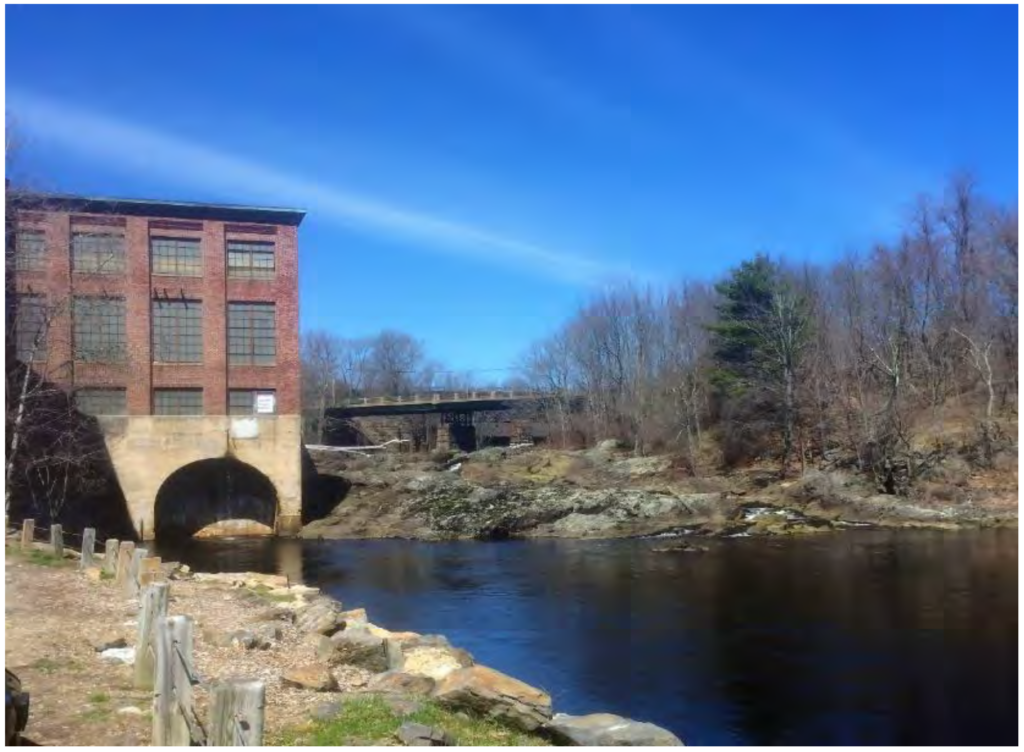
The project is partially located within the Salmon Falls Mill Historic District, which is listed on the National Register of Historic Places. The District is located on the New Hampshire side of the riverbank and includes four textile mill buildings and their contributing structures, including the Rollinsford powerhouse, dam, and intake headwork structure. The District buildings were constructed between 1840 and 1860, and are made from red brick, a typical example of a small northern New England textile manufacturing community. Presently, the four textile mill buildings are occupied by a guild of artists, and also used for office and commercial spaces. The Boston and Maine Railroad Bridge and the Rollinsford Dam are contributing resources to the character of the District. The Boston and Maine Railroad Bridge that spans the Salmon Falls River just downstream of the Project dam was constructed in 1888 as a lattice-deck, truss bridge with a cut-stone masonry sub-structure. The Project dam was constructed between 1909 and 1910, replacing the original 1843 wooden dam.
The project has a relatively small footprint, and there are no official project recreation facilities. However, the Town of Rollinsford owns, operates, and maintains several recreation facilities partially within and/or adjacent to the project boundary. Bicentennial Park is located just upstream of the dam along the New Hampshire side of the impoundment providing a gazebo, benches, parking for a few vehicles, and a gravel and concrete boat ramp that provides access to the impoundment. There is also an unmarked, primitive trail nearby, and downstream, the South Berwick Project has a boat launch at that project’s impoundment. There are other recreation sites adjacent to the Rollinsford Project including Malley Farm and The Mills at Salmon Falls.
Compliance Status
The Certificate includes the following facility-specific conditions:
Condition 1: In applicable annual compliance submittals to LIHI, the facility Owner shall provide a summary of water quality monitoring results from 2023 and 2024 including agency comments, and any proposed operational alternatives to ensure that water quality standards are met including agency consultation and, if needed, a plan and schedule for implementation of the selected alternative(s).
Condition 2: In annual compliance submittals to LIHI, the facility Owner shall provide updates on the status of upstream and downstream fish passage activities including construction of interim and permanent fishways or alternative prescriptions, results of studies and monitoring and agency comments on them, and any related agency consultation until all passage measures are implemented and deemed sufficient by the resource agencies.
Condition 3: In annual compliance submittals to LIHI, the facility Owner shall report on consultation with MDIFW regarding opportunities for improvements to access streamside angling opportunities with a plan and schedule for implementation, if improvements are needed. If no improvements are required, this result shall be reported with documentation of agreement by MDIFW.
2025: No material changes or compliance issues were identified. The project remains in compliance based on the annual review. For Condition 1, the project reported filing the water quality report. For Condition 2, the project reported that the downstream fish passage installation was completed. For Condition 3, the project provided a memo with recommendations to MDIFW and is awaiting their response.
2024: No material changes or compliance issues were identified. The project remains in compliance based on the annual review. For Condition 1, the project reported conducting a water quality study in 2024 with more monitoring planned for 2025. For Condition 2, the project reported preparing final design documents for downstream fish passage. For Condition 3, the project reported preparing detailed analysis of the current recreational assets in the immediate area including stream side angling opportunities.
2023: No material changes or compliance issues were identified. The project remains in compliance based on the annual review. In 2023, the project filed with FERC several license required plans. For Condition 1, the project reported receiving an extension on water quality monitoring due to high flows in 2023. For Condition 2, the project reported consultation with the U.S. Fish and Wildlife Service and other agencies in the design process for the installation of downstream fish passage facilities, including a site visit and meeting to discuss conceptual design alternatives. For Condition 3, the project reported on ongoing consultation with MDIFW on bypass reach access.
2022: Annual reporting for the current Certificate has not yet taken effect.
Certification History
April 21, 2023: The Low Impact Hydropower Institute has preliminarily approved Low Impact Certification for the Rollinsford (pending LIHI #196) Hydroelectric Project. This decision is preliminary pending the 30-day appeal window. Only those who commented on the initial applications during the 60-day comment period are eligible to file an appeal. Such appeal needs to include an explanation as to how the Projects do not meet the LIHI criteria. Appeal requests can be submitted by email to comments@lowimpacthydro.org with “Rollinsford Project” in the subject line, or by mail addressed to the Low Impact Hydropower Institute, 1167 Massachusetts Ave, Arlington, MA 02476. All requests will be posted to the website. The applicant will have an opportunity to respond and any response will also be posted. Requests must be received by 5 pm Eastern time on May 24, 2023. The full application and reviewer’s report are available below. If no appeal requests are received the certification terms will be December 30, 2022 through December 29, 2032.
January 4, 2023: The Low Impact Hydropower Institute has received a complete application for Low Impact Certification of the Rollinsford Hydroelectric Project. LIHI is seeking public comment on this application. Specifically, we are interested in knowing whether you think the Project meets the LIHI Low Impact Certification Criteria, as revised in the 2nd Edition Handbook. The Project’s application materials can be found below. Comments that are directly tied to specific LIHI criteria (flows, water quality, fish passage, etc.) will be most helpful, but all comments will be considered. Comments may be submitted to the Institute by e-mail at comments@lowimpacthydro.org with “Rollinsford Project Comments” in the subject line, or by mail addressed to the Low Impact Hydropower Institute, 1167 Massachusetts Avenue, Arlington, MA 02476. Comments must be received on or before 5 pm Eastern time on March 5, 2023 to be considered. All comments will be posted to the web site and the applicant will have an opportunity to respond. Any response will also be posted.
Certification Files
2023 Certification
- Rollinsford Certification Review Report 2023
- Rollinsford Project – Certification Application 2022
- Maine Council of Trout Unlimited Comment Letter – Rollinsford Certification 2023