LIHI Certificate #96 - Red Bridge Project, Massachusetts
| Project Name | Red Bridge |
| LIHI Certificate No. | 96 |
| LIHI Certificate Term |
March 27, 2023 – March 26, 2033 |
| Owner | Central Rivers Power MA, LLC, a subsidiary of LS Power/ Patriot Hydro, LLC |
| State | Massachusetts |
| Location | Located at approximate river mile 15.2 on the Chicopee River, in the Towns of Wilbraham, Ludlow, Palmer, and Belchertown in Hampden and Hampshire Counties, Massachusetts. |
| Installed Capacity | 4.5 MW |
| Average Annual Generation | 12,715 MWh |
| Facility Type | Run of river |
| FERC No. | P-10676 exempt 1992 |
The Red Bridge Project is located in the Towns of Wilbraham, Ludlow, Palmer and Belchertown in Hampden and Hampshire Counties, Massachusetts, on the Chicopee River. The Project dam crosses the town line between Wilbraham and Ludlow; the powerhouse is located in Wilbraham. The impoundment extends in a northeasterly direction, bordering Belchertown and Palmer. The project was originally constructed in 1901 by the Ludlow Manufacturing Company.
Although the Chicopee River is only 18 miles long, its watershed is 721 square miles, the largest in all of Massachusetts, and the largest tributary watershed to the Connecticut River. During the Industrial Revolution, the Chicopee River became a particularly sought-after destination for hydropower, largely because it drops 260 feet over its course.
The project is the upstream most of six dam on the Chicopee River. Downstream dams are the Collins Project (LIHI #88), Indian Orchard (LIHI #112), Chicopee Falls (FERC No. 6522), and Dwight (LIHI #170).
The project includes a dam, canal headgate house, power canal, two operating penstocks, a powerhouse with two generating units, a tailrace channel and appurtenant facilities. Two flood control dikes are located on the northeast shore of the impoundment upstream of the dam.
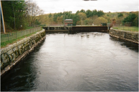
The dam crosses the Chicopee River in a roughly north to south direction and is composed of three sections. The northern section of the dam is composed of a 165-foot-long earthen embankment with a concrete core. The middle section of the dam is a 300-foot-long overflow spillway, consisting of rubble stone with cut-granite facing. The southern section is a 362-foot-long earthen embankment with a concrete core. The maximum height of the dam is approximately 51 feet. Cut-stone abutments separate the two earthen sections from the middle spillway section. The dam creates a bypassed reach approximately 2,160 feet long.
The canal headgate house is a wooden structure on a granite block foundation, housing the 10 intake gates that control flow from the impoundment to the power canal. The manually-operated headgates are all steel construction, 5.5 feet wide by 8.5 feet high.
The power canal extends from the headgates to the penstock intake structure. The canal is approximately 340 feet long by 73 feet wide by 13 feet deep. The inner sidewalls are constructed of cut-granite. Sloped earthen embankments create the outer walls and the floor of the canal is concrete.
The canal leads to the penstock intake structure for the two operating and two abandoned penstocks. Adjacent to the trashracks on the upstream face of the intake is a cut-stone ice sluice that crosses beneath Red Bridge Road and discharges back into the Chicopee River. There is one cast iron drain gate, 3 feet wide by 2 feet high, operated by a lead screw mechanism. Two operable and two inoperable 13-foot-diameter, 100-foot-long steel penstocks lead underground to the powerhouse. The two inoperable penstocks were taken out of service in 1938.
The powerhouse is constructed of brick and cut stone. The original circa 1901 equipment included horizontal waterwheels and 40-cycle generators. The original waterwheels for Units No. 1 and No. 2 were retired in 1938. The powerhouse contains wells for the discontinued Units No. 1 and No. 2 at the northerly end and the operating Units No.3 and No. 4 at the southerly end of the structure. The project has a total installed capacity of 4.5 MW. The flows from the two operating units discharge through two tailrace bays into the tailrace canal. The tailrace canal runs 735 feet in a southerly direction to where the flow re-enters the Chicopee River.
The flood control dikes are situated adjacent to the northeast shore of the impoundment, approximately 1,500 feet upstream of the dam. The first of these (known as the Railroad Dike) is of earth construction and is approximately 60 feet wide at its base, 50 feet long and rises 10 feet. The second dike (known as the Alden Street Dike) is located approximately 650 feet north of the Railroad Dike and extends northeasterly for approximately
The project operates in a run-of-river mode and impounds a 185-acre reservoir. Impoundment level fluctuations are limited to +/- 0.25 feet. The project provides a minimum bypass flow of 237 cfs from April 1 – June 30, and 100 cfs the rest of the year. This flow regime was developed in consultation with US Fish and Wildlife Service and the Massachusetts Division of Fish and Wildlife (MDFW) to support water quality and fisheries habitat.
Waters within the project reach are impaired for invasive aquatic plants. Massachusetts Department of Environmental Protection confirmed that the project is not responsible for the impairments, pending confirmatory sampling.
The Chicopee River watershed is not currently the subject of migratory fish management efforts. American eel is the only migratory species found throughout the Chicopee River system. Downstream dams create a barrier to upstream passage for anadromous fish species. With the exception of American eel, it is unlikely that migratory species may be found in the project area. Additionally, the project was constructed well after the first dams were installed on the river, dating back to the late 1800s. Though not specifically designed for it, the minimum flow gate permits downstream passage for riverine fish and eels.
The project lands consist of 4 acres. This includes project structures, adjacent fields, and some forested lands. No lands of significant ecological value exist in the vicinity of the project. The project requires an erosion control plan should any land-disturbing/clearing activities be planned.
Threatened or endangered species potentially present in the project vicinity include the Northern long-eared bat which has the potential for habitat statewide. Consultation with MDFW indicated that none of the project areas are mapped as Priority or Estimated Habitat, thus the bat is not expected to be found in the project area.
The project is included in the National Register of Historic Places as a part of the Ludlow Village Historic District. Consultation with the State Historic Preservation Office must occur before any land-disturbing activities are performed or any modifications of the historic features of the project.
Recreational resources at the project include small boat access, picnic facilities, a hiking trail, and a canoe put-in below the powerhouse tailrace. These facilities are now overseen by the Massachusetts Department of Conservation and Recreation and the MDFW. Public access is provided free of charge.
Compliance Status
The Certificate includes the following facility-specific conditions:
Condition 1: The facility Owner shall provide LIHI a copy of the report on the results of the water quality testing to be conducted along with comments received from USFWS and MDEP within 60 days of report finalization. Currently, the report is scheduled to be completed by November 30, 2024. If additional testing or other actions are found to be required as a result of this study, then the plan and schedule for implementing those actions shall also be provided to LIHI.
Condition 2: The facility Owner shall notify LIHI when powerhouse and related repairs are completed and operations resume. Notification shall include documentation of any permanent changes made to facility structures or operations as a result of the powerhouse collapse. LIHI reserves the right to modify the Certification or conditions in light of any changes made.
2026: No material changes or compliance issues were identified. The project remains in compliance based on the annual review. The project remains out of service. For Conditions 1 and 2, the project reported no changes.
2025: No material changes or compliance issues were identified. The project remains in compliance based on the annual review. The project remains out of service. For Condition 1, the project reported no studies were conducted due to project being out of service. For Condition 2, the project reported on the status of powerhouse repairs.
2024: No material changes or compliance issues were identified. The project remains in compliance based on the annual review. On August 22, 2023 the powerhouse partially collapsed resulting in minor environmental disturbance from debris and a small amount of mineral oil entering the river – the project was not operating at the time so effects remained localized to the tailrace. The project remains out of service. For Condition 1, the project reported that due to the powerhouse collapse which resulted in all river flow passing through the bypass reach, no water quality study was undertaken. There were also abnormally high river flows during the summer of 2023 and resource agencies agreed to postpone the study to 2024. For Condition 2 the project reported that the facility and powerhouse continue to be evaluated.
2023: Annual reporting for the current Certificate has not yet taken effect.
Certification History
January 3, 2024: The Low Impact Hydropower Institute has issued a final decision on the mid-term recertifications of the Red Bridge, Putts Bridge, Indian Orchard, and Dwight Hydroelectric Projects. These projects are located on the Chicopee River in Massachusetts. The preliminary decision was announced on November 28, 2023 starting the 30-day appeal window. That window closed on December 28, 2023 and no appeals were filed. Therefore, the decision to recertify the projects is now final. The new project term is shown in the table above and the full mid-term review application and review report can be found below.
November 28, 2023: The Low Impact Hydropower Institute has preliminarily approved Low Impact recertification for the Red Bridge, Putts Bridge, Indian Orchard and Dwight Projects Hydroelectric Projects located on the Chicopee River in Massachusetts. This decision is preliminary pending the 30-day appeal window. Only those who commented on the initial application during the 60-day comment period are eligible to file an appeal. Such appeal needs to include an explanation as to how the Project does not meet the LIHI criteria. Appeal requests can be submitted by email to comments@lowimpacthydro.org with “Chicopee River Projects” in the subject line, or by mail addressed to the Low Impact Hydropower Institute, 1167 Massachusetts Ave, Arlington, MA 02476. All requests will be posted to the website. The applicant will have an opportunity to respond, and any response will also be posted. Requests must be received by 5 pm Eastern time on December 28, 2023. The consolidated review report can be found below. If no appeal requests are filed, the new certification term will be March 27, 2023 – March 26, 2033.
August 17, 2023: Four LIHI Certified projects located on the Chicopee River in Massachusetts received a consolidated amendment to their FERC exemptions on March 13, 2023. The projects are Red Bridge (LIHI #96), Putts Bridge (LIHI #102), Indian Orchard (LIHI #112), and Dwight (LIHI #170). The amendment authorized changes in each project’s operations from peaking to run-of-river along with changes in bypass reach minimum flows at some projects. In accordance with Section 5.3.4 of the 2nd Edition LIHI Handbook, Revision 2.05, issuance of a FERC exemption amendment that affects the LIHI criteria constitutes a “material change” and triggers a mid-term LIHI Certification review. New Certificate terms can be granted if the projects continue to satisfy the LIHI criterion, even if the current certification terms have not yet expired. The applicant, Central Rivers Power, MA, LLC (a subsidiary of LS Power/ Patriot Hydro, LLC), has submitted a summary of the operational changes related to the FERC exemption amendment. Documents are available in the Certification Files Section of each project webpage:
- Red Bridge – LIHI #96 – see files below.
- Putts Bridge – LIHI #102
- Indian Orchard – LIHI #112
- Dwight – LIHI #170
A 60-day public comment period is being opened to allow stakeholders to comment on the submittal. All comments received will be incorporated into the mid-term review report, posted on the LIHI website, and incorporated into the preliminary decision to recertify the projects. Comments can be submitted to mailto:comments@lowimpacthydro.org with “Chicopee River Projects” in the subject line. Comments must be received by 5 pm Eastern time on October 16, 2023.
January 1, 2022: The LIHI Certificate term has been extended in accordance with Revision 2.05 of the LIHI 2nd Edition Certification Handbook issued January 1, 2022. Refer to the facility table above for the new term.
December 18, 2018: The 30 day appeal window for the Red Bridge Hydroelectric Project has now ended and no appeals were filed. Therefore, the preliminary decision is now final and the Red Bridge Hydroelectric Project has been approved for a new 5-year term, effective March 27, 2017 and expiring March 26, 2022.
November 15, 2018: The Low Impact Hydropower Institute (LIHI) has preliminarily approved the Red Bridge Hydroelectric Project for a new 5-year term of Low Impact Certification. This decision is preliminary pending the 30-day appeal window. Only those who commented on the initial application during the 60-day comment period are eligible to file an appeal. Such appeal needs to include an explanation as to how the Project does not meet the LIHI criteria. Appeal requests can be submitted by email to comments@lowimpacthydro.org with “Red Bridge Hydroelectric Project” in the subject line, or by mail addressed to the Low Impact Hydropower Institute, 329 Massachusetts Ave, Suite 2, Lexington, MA 02420. All requests will be posted to the website. The applicant will have an opportunity to respond and any response will also be posted. Requests must be received by 5 pm Eastern time on December 15, 2018. The full application and reviewers report are available below. If no appeal requests are received and the decision becomes final, the Certification term for the Red Bridge Project will be March 27, 2017 through March 26, 2022.
August 7, 2018: The Low Impact Hydropower Institute has received a complete application for a new term of Low Impact Certification for the Red Bridge Hydroelectric Project (LIHI # 96). The Project is located on the Chicopee River in central Massachusetts. LIHI is seeking public comment on this application. Specifically, we are interested in knowing whether you think the Project meets the LIHI Low Impact Certification Criteria, as revised in the 2nd Edition Handbook. Please review the program and criteria in LIHI’s revised Handbook and then review the Project’s 2018 application materials below. Comments that are directly tied to specific LIHI criteria (flows, water quality, fish passage, etc.) will be most helpful, but all comments will be considered. Comments may be submitted to the Institute by e-mail at comments@lowimpacthydro.org with “Red Bridge Project Comments” in the subject line, or by mail addressed to the Low Impact Hydropower Institute, 329 Massachusetts Avenue, Suite 2, Lexington, MA 02420. Comments must be received at the Institute on or before 5 pm Eastern time on October 6, 2018 to be considered. All comments will be posted to the web site and the applicant will have an opportunity to respond. Any response will also be posted.
June 14, 2018: The Red Bridge Hydroelectric Project has been granted an extension of the current certificate term. The new expiration date is November 30, 2018.
December 26, 2017: The Red Bridge Hydroelectric Project has been granted an extension of the current certificate term. The new expiration date is June 30, 2018.
March 1, 2017: The Red Bridge Hydroelectric Project has been granted an extension of the current certificate term. The new expiration date is November 30, 2017.
July 17, 2013: At their June 25, 2013 meeting, the Low Impact Hydropower Institute’s Governing Board modified Condition D of the Red Bridge Project’s certifications.
September 16, 2012: The Red Bridge Project has been certified as low impact for a five-year term, effective March 27, 2012 and expiring March 27, 2017.
March 27, 2012: Essential Power LLC has submitted an application for the certification of the Red Bridge Project. Public comment period has been opened.
Certification Files
2023 Mid-term Review
- Chicopee River Projects – Mid-term Review Report
- Chicopee River Projects – Mid-term Review Submittal
2018 Recertification
- Red Bridge Recertification Review Report 2018
- Red Bridge Recertification Application
- Red Bridge Recertification Attachments
2012 Certification
- Red Bridge Certification Review Report
- Red Bridge Certification Questionnaire
- Red Bridge Application and Appendices
- Application Appendix – US Fish and Wildlife Letter 2011
- Application Appendix – Massachusetts Department of Environmental Protection 2011
- Application Appendix – Minimum Flow Monitoring Plan 2012
- Application Appendix – Massachusetts Historical Commission Letter 2011
- Application Appendix – North American Energy Alliance Letter 2011
- Application Appendix – FERC Letter 2011
- Application Appendix – Massachusetts Department of Fish and Game Letter 2011
- Slater Comment Letter – Massachusetts Department of Fish and Game 2012