LIHI Certificate #69 - North Umpqua Project, Oregon
| Project Name | North Umpqua |
| LIHI Certificate No. | 69 |
| LIHI Certificate Term | December 7, 2022 – December 6, 2037 |
| Owner | PacifiCorp Energy |
| State | Oregon |
| Location | Located between river mile 73 and 93 on on the North Umpqua River and two of its tributaries – Clearwater River between river mile 4.8 and 81, and at river mile 7.03 on Fish Creek, in south-central Oregon on the west side of the Cascade Moutain range in Douglas County. |
| Installed Capacity | Total: 194 MW Lemolo No. 1: 32 MW Lemolo No. 2: 38.5 MW Clearwater No. 1: 15 MW Clearwater No. 2: 26 MW Toketee: 42.5 MW Fish Creek: 11 MW Slide Creek: 18 MW Soda Springs: 11 MW |
| Average Annual Generation | Total: 769.5 GWh Lemolo No. 1: 132.8 GWh Lemolo No. 2: 155.8 GWh Clearwater No. 1: 44.1 GWh Clearwater No. 2: 47.5 GWh Toketee: 217.8 GWh Fish Creek: 40.3 GWh Slide Creek: 76.5 GWh Soda Springs: 54.7 GWh |
| Facility Type | Peaking |
| FERC No. | P-1927 issued in 2003, expires 10/31/2038 |
The North Umpqua Project is located in south-central Oregon on the west side of the Cascade Mountains, along the North Umpqua River and two of its tributaries, Clearwater River and Fish Creek. The headwaters of the North Umpqua River are located at an elevation of over 6,000 feet on the western slope of the High Cascade Mountain Range near Maidu Lake. Over 20% of the North Umpqua River watershed lies above 5,500 feet and the river drains about 470 square miles before joining the South Umpqua River west of Roseburg. Both the North and South Umpqua Rivers have a rugged topography with steep canyons and rapid elevation changes, and both have been heavily influenced by volcanic activity. Together, the rivers form one of the longest coastal basins in Oregon, approximately 211 miles in length, with a drainage area of over 4,700 square miles. In 1988, the United States Congress designated approximately 33 miles of the North Umpqua River as part of the National Wild and Scenic River program.
The project is comprised of eight developments: Lemolo No. 1, Lemolo No. 2, Clearwater No. 1, Clearwater No. 2, Toketee, Fish Creek, Slide Creek, and Soda Springs. The project was constructed between 1947 and 1956, consisting of the dams and canals that divert water to the eight developments, each of which has a powerhouse and dam.
The project includes eight developments:
- Lemolo No. 1: The Lemolo No. 1 development is the furthest upstream development in the North Umpqua project. It includes a 120-foot-high, 885-foot-long rockfill diversion dam with concrete facing. It has a 33-foot-long gated, ogee-crested spillway section and a 67-foot-long ungated, ogee-crested concrete spillway section equipped with 3-foot-high flashboards. The dam impounds the 419-acre Lemolo Reservoir. 16,310 feet of gunite-lined canal and concrete flumes extend from the dam to the 12-acre forebay with 46-acre-feet of active storage and concrete penstock intake, which has a trashrack and 15.9-foot-wide Tainter gate. The steel penstock is 7,338 feet long with a diameter ranging from 9.7 to 7.0 feet at the powerhouse. The powerhouse is located on the North Umpqua River immediately upstream of Warm Springs Creek, 4.5 miles downstream of the dam at Lemolo Lake. The reinforced concrete powerplant contains a single vertical shaft Francis-type turbine-generator with a rated capacity of 32 MW. Storage in Lemolo Reservoir is used to control floods, increase power generation when demand is high in the late fall, and augment flows in the river downstream.
- Lemolo No. 2: The Lemolo No. 2 diversion dam is approximately 190 feet downstream of the Lemolo No. 1 powerhouse. This concrete gravity dam is 350 feet long, 25 feet high and is un-gated and ogee-crested with flashboards. It impounds 1.4 acres with no active reservoir storage. Water is drawn through a concrete intake structure equipped with a trashrack, Tainter gate and side channel spillway. The 69,989 feet of waterway, including canals, flumes, and an inverted siphon, extend from the diversion dam to a 24.2-acre earthen forebay. The forebay has a total maximum storage capacity of 230.6 acre-feet. A 3,975-foot-long steel penstock with diameter ranging from 10.5 to 7.3 feet leads to the powerhouse. The reinforced concrete powerplant contains a single vertical shaft Francis-type turbine-generator with a rated capacity of 38.5 MW. The Lemolo No. 2 powerhouse is approximately 3,500 feet upstream of Toketee Lake.
- Toketee: The Toketee development, located at the confluence of the Clearwater and North Umpqua Rivers, includes a 58-foot-high 1,381-foot-long earthfill embankment dam on the North Umpqua River. The dam has a 310-foot-long concrete spillway section and impounds the 96.9-acre Toketee Reservoir. The 6,994 feet of wood-stave pipe and concrete-lined and unlined tunnel extend from the dam to the penstock. The penstock consists of a 1,067-foot-long steel conduit that splits into three approximately 158-footlong sections near its downstream end. The powerhouse contains three equal sized, vertical shaft Francis-type turbine-generators that have a combined installed capacity of 42.5 MW. The powerhouse is located on the North Umpqua River approximately two miles downstream of Toketee Reservoir, which serves as the forebay for the development and provides active storage to regulate flow through the powerhouse.
- Fish Creek: The Fish Creek development diversion dam is located on Fish Creek, approximately 6 miles upstream of the creek’s confluence with the North Umpqua River. The 6.5-foot-high, 133-foot- long concrete dam includes a 30-foot-long, ogee spillway section, a fishway and sluiceway. The dam impounds 3 acres with no active storage. The Fish Creek waterway intake is located northwest of the Fish Creek diversion dam and consists of two impoundments separated by a fish screen structure and supporting facilities. The 25,662 feet of canal and flumes extend from the diversion dam to a 9.3-acre clay-lined excavated forebay and gated intake structure. The forebay has a maximum total storage capacity of 110.3 acre-feet and is used to reregulate water from off-peak to peak demand periods. A 2,358-foot-long steel penstock with diameter ranging from 4.5 to 3 feet carries water to the powerplant. The reinforced concrete powerplant contains a single vertical shaft impulse-type turbine-generator set with a rated capacity of 11 MW. The Fish Creek powerhouse is located on the North Umpqua River between the Toketee powerhouse and the Slide Creek diversion dam.
- Slide Creek: The Slide Creek development includes a diversion dam located on the North Umpqua River 900 feet downstream of the Toketee powerhouse. The 30-foot-high, 183-foot-long concrete dam includes a 72 –foot-long, gated concrete ogee spillway section and a gated, concrete intake structure with trashrack. The dam impounds a 2-acre reservoir with a maximum total storage capacity of 43 acre-feet. The 9,653 feet of canal and flumes extend from the dam to a concrete penstock intake structure that includes trashracks and a Tainter gate. The steel penstock that carriers the water to the powerplant is 374 feet long and 12 feet in diameter. The reinforced concrete powerplant contains a single vertical shaft Francis-type turbine-generator with a rated capacity of 18 MW. The powerhouse is located on the North Umpqua River 1.3 miles upstream of Soda Springs dam.
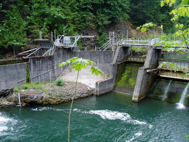
- Soda Springs: The Soda Springs development includes a diversion dam located on the North Umpqua River about 1.3 miles downstream of the Slide Creek powerhouse. The 309-foot-long, 77-foot-high concrete arch dam includes a 36-foot-long, gated, concrete ogee spillway section. It impounds a 31.5-acre reservoir with a total maximum storage capacity of 411.6 acre-feet. There are two waterway intakes. The primary intake (south intake structure) is a 36-foot-wide concrete structure with a trashrack, 285-foot-long concrete structure containing the fish screens, and two headgates at the bifurcated flowline entrance. The secondary intake (north intake structure) is a 41-foot-wide concrete structure with trashrack, and a steel fixed-wheel intake gate. A 2,112-foot-long steel flowline extends from the north intake at the diversion dam to an 82-foot-high, 30-foot-diameter surge tank. A 168-foot-long, 12-foot-diameter steel penstock extends from the surge tank to a reinforced concrete powerhouse. The powerplant has a single vertical shaft Francis-type turbine- generator set with a rated capacity of 11 MW. The storage capacity of the Soda Springs reservoir is used to ensure a minimum flow in the North Umpqua River downstream of the development.
- Clearwater No. 1: The Clearwater No. 1 development is the uppermost development on the Clearwater River, which has its confluence with the North Umpqua River immediately downstream of Toketee dam. The Clearwater No. 1 diversion dam is located approximately 8.1 miles upstream of Toketee Reservoir. The Clearwater No. 1 dam is an earthfill dam, 17 feet high and 1,426 feet long and includes a 102-foot-long, un-gated concrete spillway with flashboards. It impounds the 11.8-acre Stump Lake, which has a maximum storage capacity of 30.2 acre-feet. The concrete intake structure is equipped with a trashrack, timber gate and side channel spillway. The 13,037 feet of canal and flumes extend from Stump Lake dam to a 16.3-acre clay-lined excavated forebay and gated concrete intake structure. The forebay has a total maximum storage capacity of 120.8 acre-feet. A 4,863-foot-long penstock with diameter ranging from 6.7 to 5.0 feet leads to the powerhouse. The reinforced concrete powerplant contains a single vertical shaft Francis-type turbine-generator with a rated capacity of 15 MW. The powerplant discharges immediately upstream of Mowich Creek and directly into the Clearwater No. 2 diversion impoundment.
- Clearwater No. 2: The Clearwater No. 2 development is located 140 feet downstream from the Clearwater No. 1 powerhouse immediately downstream of Mowich Creek on the Clearwater River. The diversion dam is an 18-foot-high, 157-foot-long concrete structure with a 47-foot-long concrete spillway section and an intake with a trashrack. The dam impounds 1.2 acres with no active storage. The 31,235 feet of canal and flumes extend from the diversion dam to an 8.6-acre clay-lined excavated forebay and gated intake structure. The forebay has a total maximum storage capacity of 70.7 acre-feet. A 1,169-foot-long steel penstock with diameter ranging from 7.2 to 6.3 feet carries water to the powerhouse. The reinforced concrete powerhouse is located on the North Umpqua River at Toketee Lake. It contains a single vertical shaft Francis-type turbine-generator with a rated capacity of 26 MW.
The project operates in a peaking mode, generating more electricity during high demand periods. Storage capacity is used at each of the reservoirs and forebays for this purpose, but relatively little storage is available at the developments, with the exception of Lemolo Reservoir, which is the primary source of water storage for shaping flows to daily peaking operations for the downstream developments. Clearwater Nos. 1 and 2 and Lemolo No. 2 developments usually are operated on a continuous basis because of their limited storage capacity. The Lemolo No. 1 development is also operated continuously although at very low generating levels during non-peak times. The Soda Springs development is used for reregulation of flows from upstream developments and is operated to release a baseflow based on ambient watershed runoff estimates with a goal of maintaining a relatively stable flow to the North Umpqua River below the Soda Springs powerhouse. A flow monitoring plan was developed for the project in consultation with US Fish and Wildlife Service (USFWS), the National Marine Fisheries Service (NMFS), US Forest Service (USFS), Oregon Department of Fish and Wildlife (ODFW), Oregon Department of Environmental Quality (ODEQ), Oregon Water Resources Department (OWRD), and the Federal Energy Regulatory Commission (FERC).
PLUS-Standard: The owner has implemented long-term adaptive management and habitat enhancement programs, including gravel augmentation (Soda Springs, Slide Creek, Regulated Downstream Reach), fish habitat creation (e.g., 15,000 sq ft of Chinook habitat), and sediment and large woody debris passage to restore geomorphic processes. Monitoring has confirmed sustained or improving fish use, including for all three target salmonid species – steelhead, spring Chinook salmon, and coho salmon.
Two river reaches in the project area are listed as impaired. The first listing is for harmful algal blooms in Lemolo Reservoir and the second is listed for salmon spawning temperature in the reach downstream of the Soda Springs powerhouse. A working group including ODEQ and other resource agencies determined that based on several years of monitoring, the algal bloom in Lemolo Reservoir is not caused by hydropower operations. The project owner monitors water quality in that reach and long-term data demonstrates that the project does not contribute to temperature exceedances, aside from minor excursions (approximately 1°C) recorded during extreme conditions in limited years. The North Umpqua River from Soda Springs Dam upstream to the confluence with Rock Creek, about 33.8 miles are designated as a Wild and Scenic River under the recreational classification.
Fish passage facilities were completed in 2012 to provide upstream and downstream passage as detailed via consultation with USFS, USFWS, ODFW, and NMFS. These facilities provide access to river reaches for anadromous fish species as well as riverine fish including resident trout species. The project owner contributes $100,000 (2001 dollars) annually to the Long-Term Monitoring and Predator Control Program, a fund created by the owner to monitor the passage of anadromous fish past the Soda Springs development. Passage at the development provides access to over 80% of the spawning and rearing habitat that was previously inaccessible to migratory fish especially spring Chinook salmon, on the main stem of the North Umpqua River and steelhead in Fish Creek.
PLUS-Standard: The owner has implemented a Long-Term Monitoring and Predator Control Program and has committed to contribute $100,000 annually to this fund for the duration of the license. This program monitors and evaluates the success of anadromous fish reintroduction in the North Umpqua River upstream of Soda Springs Dam. This program also created and implements a study plan, implementation plan, and monitoring and adaptive management plan to reduce predation of anadromous salmonid juveniles by nonnative predator species in Soda Springs Reservoir.
The project lands consist of 3.085 acres. As mentioned above, the terrain in the project area has a rugged topography with steep canyons and rapid elevation changes, having been heavily influenced by volcanic activity. The project owner provides funds to implement watershed protection and enhancement measures.
Threatened or endangered species potentially present in the project vicinity include Oregon Coast coho salmon (threatened), Chinook salmon (candidate), northern spotted owl (threatened, also state-listed), marbled murrelet (threatened), gray wolf (endangered), Franklin’s bumble bee (endangered), monarch butterfly (proposed), Kincaid’s lupine (threatened, also state-listed), rough popcornflower (endangered), whitebark pine (threatened), and northwestern pond turtle (proposed). NMFS was consulted to determine project impacts on Oregon Coast coho salmon and concluded that project operations were unlikely to impact the species. Similarly, USFWS concluded that project operations are unlikely to impact these species.
Several historic and cultural properties are located in the vicinity of each of the eight project developments. Thus, the project implemented a Historic Properties Management Plan (HPMP) in consultation with the Oregon State Historic Preservation Office, US Bureau of Land Management, and USFS. The plan provides guidance for protecting the properties in the project areas, and an annual report is provided detailing activities relating to the HPMP.
Recreational resources at the project include many camping areas at the developments, fishing access, boat ramps, hiking trails, and picnic areas. Public access is provided free of charge.
Compliance Status
There are no facility-specific conditions in the current Certificate.
2025: No material changes or compliance issues were identified. The project remains in compliance based on the annual review.
Prior Certification Condition satisfied in 2015. Condition 1. The owner of the North Umpqua facilities shall provide LIHI with a description of the current status and use of funds from the Mitigation Fund and the Tributary Enhancement Fund that were part of the Settlement Agreement for the most recent FERC licensing. In particular, this description shall identify the lands and waters that are benefiting from the funds and be sufficient to determine if these funds are achieving the ecological and recreational equivalent of land protection of the buffer zone referred to in Question D.1. This information will be used by LIHI staff to determine if the N. Umpqua certification qualifies for three additional years in its term. The description of the mitigation funds is due to LIHI within 60 days of issuance of the new certification.
Certification History
September 15, 2025: The Low Impact Hydropower Institute has issued a final decision on the recertification of the North Umpqua Project. No appeals were received during the appeal period which closed on September 12, 2025. The 15-year certification term is December 7, 2022 through December 6, 2037.
August 13, 2025: The Low Impact Hydropower Institute (LIHI) has preliminarily approved Low Impact recertification for the North Umpqua Hydroelectric Project. The full application and reviewer’s report are available below. This decision is preliminary pending the 30-day appeal window. Only those who commented on the initial applications during the 60-day comment period are eligible to file an appeal. Such appeal needs to include an explanation as to how the Projects do not meet the LIHI criteria. Appeal requests can be submitted by email to comments@lowimpacthydro.org with “North Umpqua Project” in the subject line, or by mail addressed to the Low Impact Hydropower Institute, 68 Harrison Ave Ste 605, PMB 113938 Boston, Massachusetts 02111-1929. All requests will be posted to the website. The applicant will have an opportunity to respond and any response will also be posted. Requests must be received by 5 pm Eastern time on September 12, 2025. If no appeal requests are received the certification term will extend to December 6, 2037.
March 11, 2025: The Low Impact Hydropower Institute (LIHI) has received a complete recertification application from PacifiCorp for the North Umpqua Project. The application is found below in the Certification Files section. LIHI is seeking comment on this application. Comments that are directly tied to specific LIHI criteria (flows, water quality, fish passage, etc.) will be most helpful, but all comments will be considered. Comments may be submitted to LIHI by e-mail at comments@lowimpacthydro.org with “North Umpqua Project Comments” in the subject line, or by mail addressed to the Low Impact Hydropower Institute, 68 Harrison Ave. Ste 605, PMB 113938, Boston MA 02111-1929. Comments must be received at the Institute on or before 5 pm Eastern time on May 10, 2025 to be considered. All comments will be posted to the web site and the applicant will have an opportunity to respond. Any response will also be posted.
August 20, 2015: As per the decision of Executive Director Michael J. Sale, upon satisfactory demonstration by PacifiCorp of the project-specific condition requirements for the North Umpqua certification issued on June 26, 2015, the term of the North Umpqua certification shall now be for eight (8) years, expiring on December 7, 2022. Please refer to the PacifiCorp response to Condition 1 documentation below.
June 26, 2015: Executive Director Michael J. Sale, using authority delegated from the LIHI Governing Board, has determined that the North Umpqua Hydroelectric Project (FERC No. P-1927) continues to satisfy the LIHI Certification Criteria. The effective certification date for the North Umpqua Project is December 7, 2014 for a five (5) year term, which will expire on December 7, 2019.
February 3, 2015: The Low Impact Hydropower Institute received a complete and timely application for a new term of Low Impact Certification for the North Umpqua hydroelectric project on November 20, 2014. Please see the application files below.
March 24, 2011: The North Umpqua Hydroelectric Project has been certified as low impact for a five year term, effective December 7, 2009 and expiring December 7, 2014.
February 9, 2010: LIHI received comments from the University of Montana, Umpqua Watersheds, Oregon Wild American Rivers, Pacific Rivers Council, Native Fish Society, and the Steamboaters. These letters are consolidated in the Stakeholder Comment Letters in the “Files” section below.
February 7, 2010: The public comment period on the application for certification has been closed.
February 4, 2010: LIHI received a comment letter from USFWS. The letter is available in the “Files” section below.
December 7, 2009: PacifiCorp Energy has submitted an application for certification of the North Umpqua Hydroelectric Project. The public comment period will remain open for 60 days.
Certification Files
2025 Recertification
- North Umpqua Recertification Review Report 2025
- North Umpqua Recertification Application 2025
- Application Attachments: 1, 2, 3, 4, 5, 6, 7, 8, 9, 10, 11, 12, 13, 14, 15, 16, 17, 18, 19, 20, 21, 22, 23, 24, 25, 26, 27, 28, 29, 30, 31
- Oregon Steamboaters, Native Fish Society, Pacific Rivers, Umpqua Watershed, and WaterWatch of Oregon Comments
- Oregon Dept of Fish and Wildlife Comments – North Umpqua RC Application 2025
- Oregon Wild Comments – North Umpqua RC Application 2025
2014 Recertification
- North Umpqua Recertification Review Report 2015
- North Umpqua Recertification Questionnaire 2014
- North Umpqua Attachments to Recertification Questionnaire 2014
- North Umpqua Recertification Statement 2014
2009 Certification
- North Umpqua Review Report 2011
- North Umpqua Certification Questionnaire
- North Umpqua Certification Attachments
- Stakeholder Comment Letters
- US Fish and Wildlife Comment Letter