LIHI Certificate #189 - Mattaceunk Project, Maine
| Project Name | Mattaceunk |
| LIHI Certificate No. | 189 |
| LIHI Certificate Term | March 28, 2022 – March 27, 2032, with option to extend to March 27, 2035 |
| Owner | Great Lakes Hydro America, LLC (a subsidiary of Brookfield Renewable Energy Group) |
| State | Maine |
| Location | River Mile 67 on the mainstem of the Penobscot River |
| Installed Capacity | 19.2 MW |
| Average Annual Generation | 123,332 MWh |
| Facility Type | Run-of-river |
| FERC No. | P-2520, issued in 2021, expires 01/31/2061 |
The Mattaceunk Project is located on the mainstem of the Penobscot River in the towns of Medway, Woodville, Mattawamkeag, and the unorganized township of Molunkus in Aroostook and Penobscot Counties, Maine. The river is approximately 75 miles long from the confluence of the West and East Branches of the Penobscot River (to form the mainstem) downstream to the head of tide in Bangor, Maine. The Penobscot River overall is 264 miles long, making it the longest river system in Maine. The river drains nearly one third of the state of Maine with a watershed area of 8,670 square miles. The basin has a low population density, is largely forested, and contains many large lakes and multiple tributaries.
The dam and powerhouse were originally constructed over a six-year period, from 1937 through 1942, by the Great Northern Paper Company. The project commenced initial commercial operation in 1942. Mattaceunk is now the third project on the mainstem Penobscot River following dam removals undertaken as part of the Lower Penobscot River Multiparty Settlement Agreement, the goal of which was to restore self-sustaining populations of 11 native species of sea-run fish along the Penobscot River in Maine. Other projects on the Penobscot include the Medway (LIHI #65), Milford (LIHI #113), Millinocket-Dolby (LIHI #167), and North Twin (LIHI #183) projects.
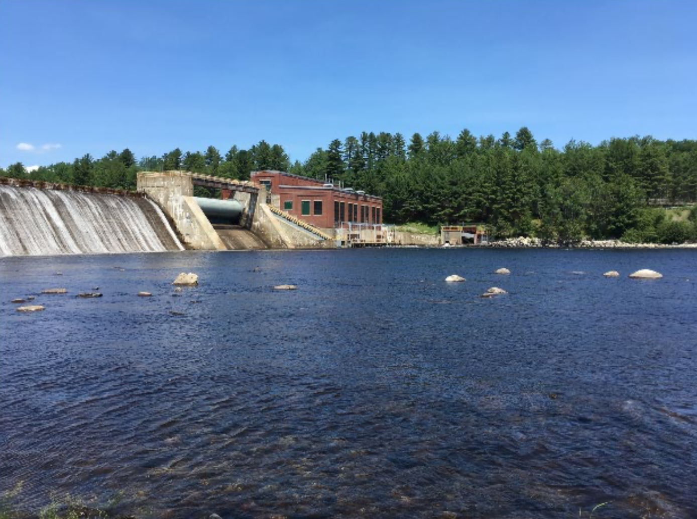
The project consists of a dam and integral powerhouse located on the mainstem approximately 7 miles downstream from the confluence of the West and East Branches of the Penobscot River. The dam includes a 658-foot-long, 70-foot-high concrete gravity overflow spillway and a 114-foot-long roller gate spillway. Additionally, a 10-foot-wide log sluice is controlled by an 8-foot-high vertical slide gate. The powerhouse measures 142-foot-long by 99-foot-wide. The power intake has trashracks that have 1-inch clear bar spacing covering the top 16 feet and 2.63-inch clear bar spacing at lower depths. By March of 2023, the trash racks will have 1-inch clear bar spacing over the entire depth. Two Kaplan and two fixed blade propeller turbine/generating units provide a total combined capacity output of 19.2 MW. A substation is located adjacent to the powerhouse and interconnects to a 9-mile-long, 34.5 kilovolt transmission line.
The project operates in a modified run of river mode and impounds a 1,664-acre reservoir. A year-round base flow of 1,674 cfs (or inflow, whichever is less) is provided with impoundment fluctuations of 2 feet with flashboards, and 1 foot without. This flow regime ensures suitable aquatic habitat.
Waters within the project reach are designated Class B, suitable for aquatic biota habitat, drinking water supply after treatment, fishing, agriculture, and recreation in and on the water. Waters within the project reach have historically been impaired due to discharges from former paper mills in Millinocket and East Millinocket. However, water quality monitoring confirmed that project waters attained all designated uses for Class B waters.
Upstream fish passage at the project is facilitated by a pool and weir design with 36 pools, each with a drop of roughly 2 feet between pools. This fishway is typically operated from May 1 through November 10 and allows for species such as American shad, blueback herring, alewife, American eel, and Atlantic salmon to pass upstream of the dam unimpeded. The project is situated in critical habitat for Atlantic salmon. Consultation with the National Marine Fisheries Service has concluded that the project is not likely to jeopardize the continued existence of the Gulf of Maine distinct population segment of Atlantic salmon. A dedicated passage for American eel is currently in the design stages and is slated for installation by September 2023. Downstream fish passage was installed in 1992 and consists of single surface inlets integral with the 1-inch clear bar spacing trashracks. The facility is operated from April 1 to June 15 and from October 17 to December 1 for salmon smolt/kelt passage. Additionally, a buried 42-inch diameter stainless steel pipe is available for passing fish to the tailrace area at a maximum flow capability of 140 cfs. A trapping and monitoring facility is provided at the outlet of the pipe.
The project lands consist of roughly 20 acres. Lands to the north are largely developed areas of municipalities, roads, and industrial sites, including a wastewater treatment plant. Otherwise, most of the project lands encompass the project structures and two small recreation sites. No shoreline lands exist around the impoundment save a small parcel that includes a canoe portage takeout and trail. Vegetation maintenance is conducted around the project and recreation sites.
Threatened or endangered species potentially present in the project vicinity include Atlantic salmon, Canada lynx, Northern long-eared bat, brook floater, tidewater mucket, yellow lampmussel, boreal snaketail, Orono sedge, least bittern, black tern, sedge wren, and common gallinule. No critical habitat exists in the project area for Canada lynx and run-of-river operations with limited impoundment fluctuation minimizes the risk to the other listed species.
The project dam and powerhouse have been determined by the Maine State Historic Preservation Officer to be eligible for listing on the National Register of Historic Places. Several other sites exist submerged in the impoundment. A Historic Properties Management Plan was developed in February 2022 and governs the protection of the historic sites and ensures coordination between the project and state and tribal historic preservation offices.
Recreational resources at the project include a portage trail around the dam and informational signage associated with it. Adjacent to the project is a town of Medway recreation complex which includes a swimming beach, sports facilities, day use areas, an Americans with Disabilities Act accessible boat ramp, and parking areas. The project also includes a downstream recreation site with angler access and a covered day use area with improvements planned by 2024. Public access is provided free of charge.
Compliance Status
The Certificate includes the following facility-specific conditions:
Condition 1: The facility Owner shall provide updates to LIHI in annual compliance statements on the ongoing status of post-licensing activities, including any studies, FERC filings, agency consultations, prescriptions and recommendations, agency comments on study results, implementation schedule changes, and final FERC approvals, as applicable. In particular, LIHI must be kept abreast of the following:
a) Partially satisfied in 2023 and 2024, pending results of effectiveness testing in 2025. Design and installation of the new upstream eel passage facility and downstream eel passage protection measures such that operation can begin as required in 2023 (delayed until 2024).
b) Partially satisfied in 2023, pending smolt passage study results. Upstream and downstream anadromous fish passage and protection measure implementation.
c) Satisfied in 2023. Negotiation process and finalization of the Atlantic Salmon Species Protection Plan.
d) Partially satisfied in 2023, ongoing reporting required. SHPO consultation and activities related to the Historical Properties Management Plan.
e) Satisfied in 2023. Installation of the pulley system and the wheel chair access ramp at the Downstream Recreation Site by February 2024.
LIHI reserves the right to modify the Certificate or conditions based on progress being made and the outcome of these items.
Condition 2 (Optional): If, at any time prior to one year before the expiration of the Certificate term, the facility Owner voluntarily completes the design, installation, initial operation, and initial shakedown of upstream and downstream anadromous fish passage facilities and protection measures, the facility Owner may request a three-year extension of the LIHI Certificate term.
2026: No material changes or compliance issues were identified. The project remains in compliance based on the annual review. For Condition 1a, the project reported upstream eel passage was installed in 2024 and the passage effectiveness study found passage effectiveness of 97.2%, additional study will be conducted in 2026. For Condition 1b, the project continues downstream passage protection measures and plans an upstream salmon effectiveness study in 2026 after completing 2025 fishway repairs. For Condition 1d the project reported on conducting erosion monitoring with additional monitoring planned for 2026. For Condition 2, the project did not report any activity.
2025: No material changes or compliance issues were identified. The project remains in compliance based on the annual review. For Condition 1a, the project reported upstream eel passage was installed in 2024 and a passage effectiveness study is planned for 2025. For Condition 1b, the project will conduct nighttime spills of 20-50% of river flow at the Project during the peak three weeks of the smolt outmigration in May of 2025. For Condition 1d the project filed the final HPMP. For Condition 2, the project did not report any activity.
2024: No material changes or compliance issues were identified. The project remains in compliance based on the annual review. For Condition 1a, the project reported upstream eel passage to be installed in 2024 and continued nighttime shutdowns and seasonal trash rack overlays installed. For Condition 1b, the project reported implementation of spill for Atlantic salmon smolts and a 3-year downstream passage study to begin in 2024. For Condition 1d the project filed the final HPMP. For Condition 2, the project did not report any activity.
2023: No material changes or compliance issues were identified. The project remains in compliance based on the annual review. For Condition 1a, the project reported filing design drawings for upstream eel passage and completion of installation of 1-inch trash rack overlays for downstream passage and plans to conduct nighttime shutdowns in 2023. For Condition 1b, the project reported implementation of spill for Atlantic salmon smolts will begin in 2023. For Condition 1c, the project filed the final Species Protection Plan. For Condition 1d the project completed consultation and filed the final HPMP. For Condition 1e, the project filed documentation of recreation enhancement completion. For Condition 2, the project did not report any activity.
2022: Annual reporting for the current Certificate has not yet taken effect.
Certification History
July 15, 2022: The decision to certify the Mattaceunk Project became final after the close of the appeals period on July 9, 2022 with no appeals filed. The certification term is March 28, 2022 to March 27, 2032 with an option to extend the term by three years.
June 9, 2022: The Low Impact Hydropower Institute (LIHI) has preliminarily approved the Mattaceunk Project for a 10-year term of Low Impact Certification, with an option to extend the term by 3 additional years. This decision is preliminary pending the 30-day appeal window. Only those who commented on the initial application during the 60-day comment period are eligible to file an appeal. Such appeal needs to include an explanation as to how the Project does not meet the LIHI criteria. Appeal requests can be submitted by email to comments@lowimpacthydro.org with “Mattaceunk Project” in the subject line, or by mail addressed to the Low Impact Hydropower Institute, 1167 Massachusetts Ave, Office 407, Arlington, MA 02476. All requests will be posted to the website. The applicant will have an opportunity to respond and any response will also be posted. Requests must be received by 5 pm Eastern time on July 9, 2022. The full application and reviewer’s report are available below. If no appeal requests are received and the decision becomes final, the Certification term for the Project will be March 28, 2022 through March 27, 2032.
March 29, 2022: The Low Impact Hydropower Institute has received a complete application for Low Impact Certification of the Mattaceunk Project. LIHI is seeking public comment on this application. Specifically, we are interested in knowing whether you think the Project meets the LIHI Low Impact Certification Criteria, as revised in the 2nd Edition Handbook. Please review the program and criteria in LIHI’s revised Handbook and then review the Project’s application materials below. Comments that are directly tied to specific LIHI criteria (flows, water quality, fish passage, etc.) will be most helpful, but all comments will be considered. Comments may be submitted to the Institute by e-mail at comments@lowimpacthydro.org with “Mattaceunk Project Comments” in the subject line, or by mail addressed to the Low Impact Hydropower Institute, 1167 Massachusetts Avenue, Arlington, MA 02476. Comments must be received on or before 5 pm Eastern time on May 28, 2022 to be considered. All comments will be posted to the web site and the applicant will have an opportunity to respond. Any response will also be posted.
Certification Files
2022 Certification
- Mattaceunk Certification Review Report 2022
- Mattaceunk LIHI Application 2022
- Trout Unlimited Comment Letter – Mattaceunk Application 2022