LIHI Certificate #18 – Smoky Mountain Project, North Carolina and Tennessee
| Project Name | Smoky Mountain |
| LIHI Certificate No. | 18 |
| LIHI Certificate Term | March 20, 2020 – March 19, 2033 |
| Owner | Brookfield Smoky Mountain Hydropower LLC, a subsidiary of Brookfield Renewable Energy Group |
| State | North Carolina, Tennessee |
| Location | Located between river mile 34 and 44 on the Little Tennessee River, and between river mile 9 and 52 on the Cheoah River in Graham and Swain Counties, North Carolina, and Blount and Monroe Counties, Tennessee. |
| Installed Capacity | 385.5 MW |
| Average Annual Generation | 1,560,635 MWh |
| Facility Type | store/release and peaking |
| FERC No. | P-2169 issued in 2005, expires 02/28/2045 |
The Smoky Mountain Project consists of four developments: Santeetlah, Cheoah, Calderwood, and Chilhowee. The Santeetlah development is located at the outlet of Lake Santeetlah on the Cheoah River in Graham County, North Carolina. There are no dams upstream of the development on the river. The Cheoah development is located downstream of the Santeetlah development on the Cheoah River where it joins the Little Tennessee in the Town of Tapoco, Swain County, North Carolina. The Calderwood development is located eight miles downstream of the Cheoah development on the Little Tennessee River in Maryville, Blount County, Tennessee. The Chilhowee development is located about ten miles downstream of the Calderwood development on the Little Tennessee River in Tallassee, Monroe County, Tennessee.
The Santeetlah development was constructed between 1925 and 1928 to provide recreation and flood control. The other three developments were built solely for power production. Cheoah was constructed from 1916 through 1919; Calderwood was constructed from 1925 through 1930; and Chilhowee was constructed from 1955 through 1957. Upstream of the Cheoah development is the Tennessee Valley Authority Fontana Dam, built in 1940s.
The project includes four developments:
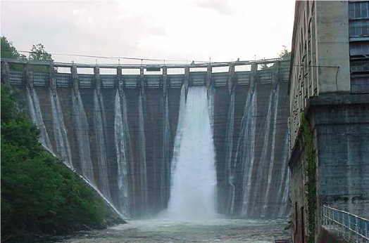
- Santeetlah Development: The dam is a 1,054-foot-long, 216-foot-high concrete arch dam which creates a 2,881-acre impoundment. The dam has a spillway section containing six 25-foot-wide, 12-foot-high Tainter gates. A 5-mile-long conveyance structures pass water from the intake to a surge tank; these include six 11-foot-diameter pipelines, two steel lined tunnels, and three11-foot-diameter, horseshoe shaped tunnels that are excavated through rock and concrete lined. The powerhouse has two identical vertical Francis turbines with a combined capacity of 49.2 MW.
- Cheoah Development: The dam is a 750-foot-long, 229-foot-high curved concrete gravity dam which creates a 644-acre impoundment. The spillway section contains nineteen Tainter gates, 25 feet wide by 19 feet high. There are five individual penstocks, one for each turbine. The trashracks have 4.75-inch clear spacing. The powerhouse contains five vertical Francis turbines with a combined capacity of 147.3 MW.
- Chilhowee Development: The dam is a 1,483-foot-long, 88.5-foot-high concrete gravity dam which creates a1,734-acre impoundment. The spillway section contains six Tainter gates, 24 feet wide by 38 feet high. The intake has trashracks with 6.0-inch clear spacing. It and powerhouse are integral with the dam. The powerhouse is located immediately downstream of the intake structure between the Tainter gate-controlled spillway section and the left non-overflow. The powerhouse consists of a concrete substructure containing three water passages leading to three identical Kaplan turbines with a combined capacity of 52.2 MW.
- Calderwood Development: The dam is a 916-foot-long, 230-foot-high curved concrete arch dam which creates a 570-acre impoundment. The spillway section contains twenty-four 24-foot wide and 20-foot-high stoney gates (vertical roller gates). A 2,050-foot-long tunnel conveys water from the intake to the powerhouse. The upstream section of the tunnel is 26.5 feet in diameter and approximately 220 feet long. It transitions into a horseshoe shape section that is 26 feet wide at the invert and has a 13-foot radius on the upper half‐round section. The powerhouse intake tunnel separates into three 16-foot-diameter steel penstocks that are concreted within the rock ledge. These penstocks have trashracks with 6.0-inch clear spacing and end below the control valve house which is located on a steep rock cliff above the powerhouse which contains three vertical Francis turbines with a combined capacity of 140.4 MW.
The Santeetlah development operates as a store-and-release facility. Impoundment fluctuations are limited to 5 feet from April 1 to November 1, and up to 9.9 feet from December 1 to March 1. This flow regime was prescribed via the project’s relicensing Settlement Agreement which was developed in consultation with state and federal agencies, the Eastern Band of the Cherokee Indians (EBCI), local governments, homeowner associations, and local/national NGOs. The regime was designed for protection and enhancement of water resources including aquatic habitat, water quality, and wetlands in the reservoir area as well as the downstream reaches of the river. The development provides a minimum flow into the 9.3-mile-long bypassed reach based on average daily inflow of the three preceding months – typically ranging between 40 and 100 cfs depending on the historic average monthly flow.
The Cheoah development is operated in a daily cycle peaking mode with the upstream Fontana Project serving as the primary flow control facility. Maximum drawdown at the development is 7 feet. The Calderwood development operates similarly to Cheoah with a maximum drawdown of 6 feet. The facility provides a minimum flow into the 1.3-mile-long bypass reach typically ranging from 32.5 to 41.5 cfs in order to reduce thermal impacts on aquatic biota. The Chilhowee development has a maximum drawdown of 5 feet and provides a minimum daily outflow of 1,000 cfs from May 1 to October 31.
Waters within the project reaches are designated as Class B in the Santeetlah reservoir and Class C in the Cheoah development reaches with no impaired waters either project areas. The Calderwood reservoir waters are designated as Class C and the Chilhowee reservoir is supportive of fish and aquatic life, recreation, irrigation, and wildlife. The Little Tennessee River is listed as an impaired waterway for PCB contamination downstream of the Smoky Mountain Project though the Tennessee Department of Environment and Conservation has noted that the project is not responsible for this listing.
The Santeetlah and Cheoah developments each support productive fisheries, though no migratory species are known to exist in the project reaches. The Santeetlah impoundment is managed by the North Carolina Wildlife Resources Commission (NCWRC) as a warm-water fishery. Species include walleye, smallmouth and largemouth bass, white and black crappie, bluegill, and red breast sunfish. The Cheoah development supports a cool-water fishery with smallmouth and rock bass. Trout species are occasionally found here as well. The NCWRC also stocks the Cheoah impoundment with brook, rainbow, and brown trout. The Calderwood development is host to many species of fish. These include white sucker, rock bass, war paint shiner, mottled sculpin, river chub, northern hog sucker, red breast sunfish, largemouth bass, central stoneroller, whitetail shiner, spotfin shiner, northern striped shiner, warpaint shiner, yellow bullhead, Tennessee snub-nose darter, and rainbow trout.
US Fish and Wildlife Service (USFWS) has prescribed a fish passage translocation plan for the Chilhowee development. This management plan provides funding to USFWS to trap and relocate several native fish species to be reintroduced to the waters above the Chilhowee Dam. The number of each species to be relocated each year is decided at an annual meeting of the project owner and USFWS. The target species include spotfin chub, yellowfin madtom, smoky madtom, and duskytail darter. The Chilhowee development also operates under a tailwater fish monitoring plan to evaluate the presence of migratory fish species including lake sturgeon, black buffalo, smallmouth buffalo, river redhorse, sauger, and American eel. Currently, USFWS has not requested that further fish passage facilities be installed at the development.
The project lands consist of roughly 2,500 acres. The areas surrounding the project developments are primarily undeveloped and protected to remain that way for the benefit of fish and wildlife and their habitat. The project owner contributes to two separate mitigation funds, the North Carolina Resource Management and Enhancement Fund (NC Fund) and the Tallassee Fund. The NC Fund is used to monitor biotic and abiotic parameters of the watershed, endangered species recovery efforts, invasive species control, education efforts, and the addition of woody debris, gravel, and vegetation with the Cheoah River. These funds are used by the state and federal resource agencies and the EBCI. The Tallassee Fund is used for endangered species recovery efforts, ecosystem enhancements and restoration, invasive species management, and education and outreach efforts.
PLUS-Standard: The project owner provides annual enhancement funding of $25,000 and has purchased 11,000 acres of non-project lands for conservation via easements.
Threatened or endangered species potentially present in the project vicinity include four fish species (spotfin chub, yellowfin madtom, smoky madtom, and duskytail darter), gray bat, Indiana bat, bald eagle, Appalachian elktoe mussel, Virginia spiraea plant, Carolina northern flying squirrel, Northern long-eared bat, bog turtle, rock gnome lichen, spreading avens, white fringeless orchid, littlewing pearlymussel, noonday snail, spruce-fir moss spider, Cumberland bean, and Anthony’s riversnail. The project operates under an endangered species management plan, developed with resource agencies and which is updated every five years. This plan incorporates USFWS guidance for restoring viable populations of each species in their historic range, ultimately resulting in removal of the species from the federal endangered species list. The listed species are found throughout the four developments with some critical habitat interspersed throughout.
Each of the four developments at the project house several historic resources. The Santeetlah dam, pipeline and tunnels, powerhouse, and ancillary buildings are all listed on the National Register of Historic Places (NRHP). The Cheoah dam, penstock building, powerhouse, and ancillary buildings are also listed on the NRHP. The Calderwood dam, penstock, tunnel, powerhouse, service building, school, theater, and ancillary buildings have been added to the NRHP. An abandoned worker’s camp, prehistoric lithic scatter, and tunnel and railroad were also identified in the development area. The Chilhowee dam and powerhouse are listed on the NRHP. These historic properties are preserved under the project’s historic properties management plan. The plan was developed in consultation with the North Carolina State Historic Preservation Office (SHPO), the Tennessee SHPO, US Forest Service, Great Smoky Mountains National Park, EBCI Tribal Historic Preservation Office, and FERC. Annual reports on the condition and activities surrounding the historic properties are submitted for review by FERC, federal agencies, the SHPOs, EBCI Tribal Historic Preservation Office, the United Keetowah Band of Cherokee Indians (UKB) and the Cherokee Nation of Oklahoma.
Recreational resources at the project include:
- Santeetlah: Boat access and boat launches, campgrounds, and marinas;
- Cheoah: ADA compliant fishing piers, boat ramp, loading dock;
- Calderwood: campsites and a canoe put-in/take out;
- Chilhowee: canoe portage and fishing piers.
Public access is provided free of charge and the project consults annually with US Forest Service, and state agencies to prioritize recreational enhancements for the following year. Flow conditions and discharge forecasts are posted at https://safewaters.com/list/tennessee/little-tennessee.
Compliance Status
The Certificate includes the following facility-specific condition:
Condition satisfied in 2025. Condition 1: The facility Owner shall file with LIHI a copy of the final 2024 Tailwater Fish Monitoring Report for the Chilhowee tailrace within 60 days of report finalization and agency and FERC approval. LIHI reserves the right to modify the Certificate and conditions based on the outcome of the monitoring.
2026: No material changes or compliance issues were identified. The project remains in compliance based on the annual review.
2025: No material changes or compliance issues were identified. The project remains in compliance based on the annual review. For Condition 1, the project reported that tailwater monitoring was completed in 2024, with agency and FERC approval documentation provided, thus satisfying the condition.
2024: No material changes or compliance issues were identified. The project remains in compliance based on the annual review. For Condition 1, the project reported that tailwater monitoring is scheduled for April – September, 2024.
2023: No material changes or compliance issues were identified. The project remains in compliance based on the annual review.
2022: No material changes or compliance issues were identified. The project remains in compliance based on the annual review. The project reported on a native pollinator habitat restoration project (native plant seeding) at Calderwood conducted in ccollaboration with USFWS and the Eastern Band of Cherokee Indians.
2021: The project reported no change in status of Condition 1, and reported consultation with and approval by agencies for recreation site closures and high flow events in 2020 and 2021 due to Covid. The project remains in compliance based on the annual review.
2020: Annual reporting for the current Certificate has not yet taken effect.
Certification History
January 1, 2022: The LIHI Certificate term has been extended in accordance with Revision 2.05 of the LIHI 2nd Edition Certification Handbook issued January 1, 2022. Refer to the facility table above for the new term.
October 21, 2020: The decision to recertify the Smoky Mountain Project became final after the close of the appeals period on October 17, 2020 with no appeals filed. The Certification term is from March 20, 2020 – March 19, 2028.
September 17, 2020: The Low Impact Hydropower Institute (LIHI) has preliminarily approved the Smoky Mountain Project for a new 8-year term of Low Impact Certification. The Project is located on the Cheoah and Little Tennessee Rivers in North Carolina and Tennessee. This decision is preliminary pending the 30-day appeal window. Only those who commented on the initial application during the 60-day comment period are eligible to file an appeal. Such appeal needs to include an explanation as to how the Project does not meet the LIHI criteria. Appeal requests can be submitted by email to comments@lowimpacthydro.org with “Smoky Mountain Project” in the subject line, or by mail addressed to the Low Impact Hydropower Institute, 329 Massachusetts Ave, Suite 6, Lexington, MA 02420. All requests will be posted to the website. The applicant will have an opportunity to respond and any response will also be posted. Requests must be received by 5 pm Eastern time on October 17, 2020. The full application and reviewer’s report are available below. If no appeal requests are received and the decision becomes final, the Certification term for the Project will be March 20, 2020 through March 19, 2028.
May 27, 2020: The Low Impact Hydropower Institute has received a complete application for Low Impact recertification of the Smoky Mountain Hydroelectric Project. The complete application can be found below. LIHI is seeking public comment on this application. Comments that are directly tied to specific LIHI criteria (flows, water quality, fish passage, etc.) will be most helpful, but all comments will be considered. Comments may be submitted to the Institute by e-mail at comments@lowimpacthydro.org with “Smoky Mountain Project Comments” in the subject line, or by mail addressed to the Low Impact Hydropower Institute, 329 Massachusetts Avenue, Suite 6, Lexington, MA 02420. Comments must be received on or before 5 pm Eastern time on July 26, 2020 to be considered. All comments will be posted to the web site and the applicant will have an opportunity to respond. Any response will also be posted.
March 6, 2013: Alcoa Power Generating Inc. (APGI) has assigned ownership of the Tapoco Project to Brookfield Smoky Mountain Hydropower LLC (BSMH), as per a FERC filing date of 12/3/12. APGI sold the Tapoco Project to BSMH (sale date: November 15, 2012) and FERC transferred the Project license to BSMH. The project has been renamed the Smoky Mountain Hydro Project.
July 26, 2012: The Tapoco Hydroelectric Project continues to meet the Low Impact Hydropower Certification Criteria, and has been recertified for an eight year term, effective March 20, 2012 and expiring March 20, 2020.
March 20, 2012: Alcoa Power Generating Inc. has submitted an application for the re-certification of the Tapoco Hydroelectric Project. A public comment period will remain open until May 20, 2012.
December 1, 2005: The Tapoco Hydroelectric Project has been certified as low impact for an eight year term, effective July 25, 2005 and expiring July 25, 2013. It consists of four powerhouses and four dams and is the largest hydropower project to be certified by LIHI on the east coast.
July 25, 2005: Alcoa Power Generating Inc. has submitted an application for certification of the Tapoco Hydroelectric Project, located on the Little Tennessee and Cheoah Rivers.
Certification Files
2020 Recertification
2012 Recertification
- Smoky Mountain Recertification Review Report
- Smoky Mountain Recertification Questionnaire 2012
- Smoky Mountain Questionnaire – Supplemental Information
- Application Attachment – Agency Support Letters
- Alcoa Conveyance to Brookfield Smoky Mountain Hydropower LLC – FERC Filing
2005 Certification
- Tapoco Certification Review Report
- Tapoco Certification Application
- Friends of Santeetlah Letter
- Tennessee Water Quality Letter