LIHI Certificate #173 - Sawmill Project, New Hampshire
| Project Name | Sawmill |
| LIHI Certificate No. | 173 |
| LIHI Certificate Term | August 31, 2020 – August 30, 2030 |
| Owner | Great Lakes Hydro America, LLC, a subsidiary of Brookfield Renewable Energy Group |
| State | New Hampshire |
| Location | River Mile 138.2 – Androscoggin River |
| Installed Capacity | 3.17 MW |
| Average Annual Generation | 14,529 MWh |
| Facility Type | Run of river |
| FERC No. | Sawmill P-2422
Issued in 2025, expires 08/31/2065 |
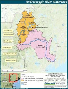
The Sawmill Project is located on the Androscoggin River in Coos County, in northern New Hampshire. The Androscoggin River is runs through the states of New Hampshire and Maine. The river joins the Kennebec River at Merrymeeting Bay in Maine before emptying into the Gulf of Maine and subsequently the Atlantic Ocean. The Androscoggin River watershed contains 19 hydroelectric projects located along the 178-mile-long river.
The Project is one of several hydroelectric projects within an 11-mile reach of the Androscoggin River between Berlin and Shelburne, New Hampshire including: Cross Power (LIHI #174), Cascade (LIHI #188), Upper Gorham (LIHI #175), Gorham (LIHI #153), and Shelburne (LIHI #176). Sawmill is the upstream most project in this reach.
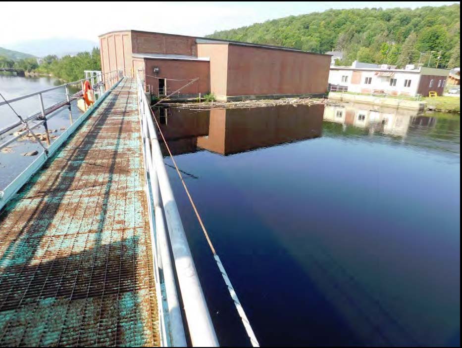
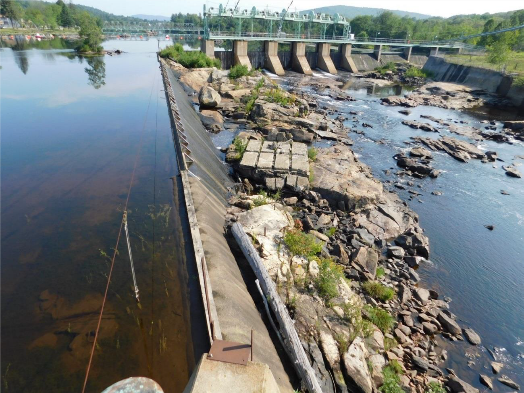
The project includes a dam, concrete retaining walls, intake canal, penstock, powerhouse, and transmission equipment. The Sawmill dam was originally constructed in 1903 and was refurbished in 1965.
The dam is 72 feet long with a maximum height of 15 feet. It is comprised of a 135-foot-long non-overflow section, a 169-foot-long concrete section varying in height from 6 to 14 feet, a 134-foot-long wastegate section with five wooden gates each 22 feet high, a 137-foot-long spillway section with hinged 7.5-foot flashboards, and a 145-foot-long by11-foot-high spillway with 21-inch steel flashboards. A 4-foot-wide, 80-foot-long concrete retaining wall on the east riverbank separates the 0.3-mile-long bypass reach from the powerhouse intake canal. A 4-foot wide, 55-foot-long retaining wall extends from the edge of the powerhouse on the west riverbank. The 360-foot-long intake canal directs inflows through a steel penstock to the powerhouse. The powerhouse is a brick and block structure that is integral to the dam and contains:
- Four turbine inlet bays 14 feet wide by 19 feet long. Each bay passes flow through14-foot-wide by 19-foot-high trashracks each with 3-inch clear spacing.
- Four identical horizontal generators. Turbines 1 and 3 are Allis-Chalmers fixed blade propeller turbines. Turbines 2 and 4 are adjustable blade propeller units. Total capacity is 3.17 MW.
The project operates in a quasi-run-of-river mode and impounds a 72.5-acre reservoir. The impoundment is allowed to fluctuate over a 6-inch range. The project provides a minimum flow of 12 cfs into the bypassed reach to provide passage flow and protect aquatic resources. This flow regime was developed in consultation with US Fish and Wildlife Service (USFWS) and the New Hampshire Department of Environmental Services (NHDES).
Waters within the project reach are designated as Class B, suitable for fishing, primary contact recreation, and water supply after treatment. The project waters are listed as impaired due to prior discharges from several paper mills. Given run-of-river operations, the project is unlikely to adversely impact water quality.
The Androscoggin River is not accessible to diadromous fish species in the project reach. Species such as alewife, blueback herring, striped bass, sea lamprey, and American shad are not present in the area due to downstream natural falls – Lewiston and Rumford Falls, in the Maine portion of the river. American eel are present in the lower reaches of the Androscoggin River though none have historically reached the upper sections of the river. The project area supports cold-water fishery habitat. New Hampshire Department of Fish and Game annually stocks brook, rainbow, and brown trout upstream of the projects. Resident river species include fallfish, smallmouth bass, white sucker, longnose dace, common shiner, spottail shiner, and yellow perch. Downstream passage can occur by means of spillway flow, low-level gate releases, and power intake flow through the trashracks. The project does not impede the successful completion of resident fish life cycles.
The project lands are limited to the area occupied by project infrastructure. The project is located on the northern edge of the City of Berlin. The east shoreline of the impoundment is bordered by sand and gravel terraces, most of which have been altered by industrial, commercial, and residential development, as well as railroad and bridge construction. The east shoreline of the impoundment is also characterized by low terraces and was altered by the railroad yard, railroad bed, mill yards, and commercial and residential development. The project’s run-of-river operations provides protection of the shoreline areas.
Threatened or endangered species potentially present in the project vicinity include the Northern long-eared bat, Canada lynx, eastern small-footed bat, little brown bat, tri-colored bat, bald eagle, Cape May warbler, evening grobeak, rusty blackbird, wood thrush, wood turtle, American marten, peregrine falcon, and common nighthawk. Plant species include auricled twayblade, mountain sweet-cicely, ovoid spikesedge, parasol sedge, pink shinleaf, purple virgin’s-bower, round-leaved orchid, smooth cliff fern, dwarf blueberry, fragrant wood fern, heart-leaved twayblade, and Hornemann’s willow-herb.
The listed bat species are not likely to be impacted by project operations as there are generally no tree-clearing activities or corridor maintenance activities. Some vegetation removal and maintenance occur to ensure dam safety but said activities adhere to the USFWS 4(d) rule concerning habitat protection for the bat species. Most of the other listed species have been noted in the project vicinity but run-of-river operations and impoundment fluctuation limits mitigate any impact on these species.
The project area does not support any known historic or cultural resources. However, the project operates under a Programmatic Agreement (PA) in consultation with the State Historic Preservation Office. The PA provides provisions detailing annual monitoring and reporting concerning repair and improvement activities conducted as well as any scheduled activities for the upcoming year.
There are no recreational facilities at the project due to safety concerns, but there are several facilities in the project vicinity. Immediately west of the Sawmill dam is Northern Forest Heritage Park, which was established by a 12-acre donation from the project’s previous owner. The park hosts river tours, cultural events, concerts, and parties. Rotary Park is located adjacent to the impoundment and provides access to the shoreline. Centennial Park, located on the impoundment, provides access via a boat launch.
Compliance Status
The Certificate includes the following facility-specific conditions:
Condition satisfied in 2026. Condition 1: The facility Owner shall provide updates to LIHI on the ongoing status of Project relicensing, including studies, FERC filings, resource agency consultation, prescriptions and recommendations, and agency comments on study results. LIHI reserves the right to modify the Certificate or conditions based on the outcome of the relicensing.
Condition 2:The facility Owner shall provide updates to LIHI on the ongoing status of the Proposed Recreation Plan including efforts with the City of Berlin’s Riverwalk project.
2025: No material changes or compliance issues were identified. The project remains in compliance based on the annual review. For Condition 1, the project provided a status update and links to relicensing documents. FERC issued its final Environmental Assessment on October 7, 2024 and NHDES issued a water quality certification on September 19, 2024. For Condition 2, the project reported recreation enhancements will be included in its relicensing recreation management plan.
2024: No material changes or compliance issues were identified. The project remains in compliance based on the annual review. For Condition 1, the project provided a status update and links to relicensing documents. FERC issued its draft Environmental Assessment on May 23, 2024. For Condition 2, the project reported recreation enhancements will be included in its relicensing recreation management plan.
2023: No material changes or compliance issues were identified. The project remains in compliance based on the annual review. For Condition 1, the project reported no change in status. For Condition 2, the project reported ongoing consultation with the City. The project reported one flow deviation, not considered a FERC violation.
2022: No material changes or compliance issues were identified. The project remains in compliance based on the annual review. For Condition 1, the project reported filing the final FERC relicensing application on August 29, 2022. For Condition 2, the project reported ongoing consultation with the City.
2021: There were no reported changes or compliance issues. The project remains in compliance based on the annual review. For Condition 1, the project reported filing of the relicensing initial study report. For Condition 2, the project reported no requests from the city and no change in the recreation plan.
2020: Annual reporting for the current Certificate has not yet taken effect.
Certification History
April 28, 2026: The Low Impact Hydropower Institute has received a complete application (see below) for a mid-term review of the Sawmill Project. The Project is one of several LIHI Certified projects located on the upper Androscoggin River in New Hampshire that were issued new FERC licenses in September 2025. In accordance with Section 5.3.4 of the 2nd Edition LIHI Handbook, issuance of a new license constitutes a “material change” and triggers a mid-term LIHI Certification review.
LIHI is seeking public comment on this application. Specifically, we are interested in knowing whether you think the Project continues to meet the LIHI Low Impact Certification Criteria, as revised in the 2nd Edition Handbook. Comments that are directly tied to specific LIHI criteria (flows, water quality, fish passage, etc.) will be most helpful, but all comments will be considered. Comments may be submitted to LIHI by e-mail at comments@lowimpacthydro.org with “Sawmill Comments” in the subject line, or by mail addressed to the Low Impact Hydropower Institute, 68 Harrison Ave. Ste 605, PMB 113938, Boston MA 02111-1929.
Comments must be received by 5 pm Eastern time on June 27, 2026 to be considered. All comments will be posted to the website, and the applicants will have an opportunity to respond. Any response will also be posted.
January 1, 2022: The LIHI Certificate term has been extended in accordance with Revision 2.05 of the LIHI 2nd Edition Certification Handbook issued January 1, 2022. Refer to the facility table above for the new term.
November 30, 2020: The decision to certify the Sawmill Project became final after the close of the appeals period on November 27, 2020 with no appeals filed. The Certification term is from August 31, 2020 – August 30, 2025.
October 27, 2020:The Low Impact Hydropower Institute (LIHI) preliminarily approved Low Impact Certification for the Sawmill, Cross Power, Upper Gorham, and Shelburne Hydroelectric Projects located on the Androscoggin River in New Hampshire. This decision is preliminary pending the 30-day appeal window. Only those who commented on the initial application during the 60-day comment period are eligible to file an appeal. Such appeal needs to include an explanation as to how the Project does not meet the LIHI criteria. Appeal requests for one or more of these projects can be submitted by email to comments@lowimpacthydro.org with “Androscoggin River-NH Projects” in the subject line, or by mail addressed to the Low Impact Hydropower Institute, 329 Massachusetts Ave, Suite 6, Lexington, MA 02420. All requests will be posted to the website. The applicant will have an opportunity to respond and any response will also be posted. Requests must be received by 5 pm Eastern time on November 27, 2020. The full application and review report are available below. If no appeal requests are received the certification term for each project will be August 31, 2020 through August 30, 2025.
August 13, 2020: The Low Impact Hydropower Institute has received a complete application for Low Impact Certification of the Sawmill, Cross Power, Upper Gorham and Shelburne Hydroelectric Projects located on the Androscoggin River in New Hampshire. LIHI is seeking public comment on this application. Specifically, we are interested in knowing whether you think the Projects meet the LIHI Low Impact Certification Criteria, as revised in the 2nd Edition Handbook. The application can be found below. Comments that are directly tied to specific LIHI criteria (flows, water quality, fish passage, etc.) will be most helpful, but all comments will be considered. Comments may be submitted to the Institute by e-mail at comments@lowimpacthydro.org with “Androscoggin River-NH Project Comments” in the subject line, or by mail addressed to the Low Impact Hydropower Institute, 329 Massachusetts Avenue, Suite 6, Lexington, MA 02420. Comments must be received on or before 5 pm Eastern time on October 12, 2020 to be considered. All comments will be posted to the web site and the applicant will have an opportunity to respond. Any response will also be posted.