LIHI Certificate #169 - Cataract Project, Maine
| Project Name | Cataract |
| LIHI Certificate No. | 169 |
| LIHI Certificate Term | April 3, 2020 – April 2, 2030 |
| Owner | Brookfield White Pine Hydro, LLC, a subsidiary of Brookfield Renewable Energy Group |
| State | Maine |
| Location | Between River Mile 6.0 and 6.3 on the Saco River |
| Installed Capacity | 6.65 MW |
| Average Annual Generation | 30,868 MWh |
| Facility Type | Run of river |
| FERC No. | 2528, issued in 1989, expires 11/30/2029 |
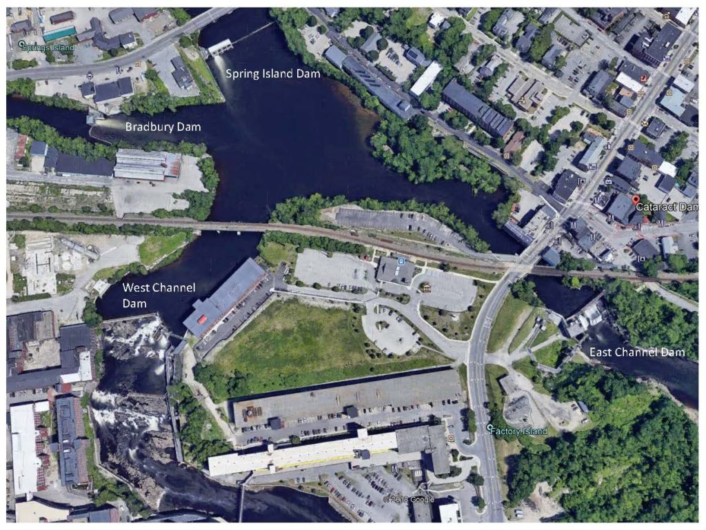
The Cataract Hydroelectric Project is located on the Saco River in the Cities of Saco and Biddeford and the Towns of Dayton and Buxton, Maine. The project is comprised of four developments – Spring Island, Bradbury, East Channel, and West Channel (from upstream to downstream). The Spring Island, Bradbury, and West Channel dams pre-date the East Channel development which was constructed in 1938. The dams were originally constructed around the turn of the 20th century to meet the hydromechanical and hydroelectric demands of industry along the Saco River. The Saco River is the fourth largest flowing river in Maine. It originates in New Hampshire and flows 134 miles through Maine, culminating at Saco Bay. The Cataract Project is the first of seven dams that generate hydroelectric power on the river, including Bonny Eagle (LIHI #182).
The project consists of four developments, two impoundments, and a single powerhouse. Project works include:
- Spring Island: Spring Island Dam consists of a natural like fishway approximately 100 feet wide by 230 feet long beginning at the East shore, an overflow section and two gate house sections. The overflow section is a concrete gravity structure topped with 18-inch pin-supported flashboards, extending 117.5 feet from the nature-like fishway to the first gate section. The gate house has four gate openings. There are three Tainter gates, each 16 feet wide by 11 feet high. The most easterly of the openings is closed by timber stop logs and a slide gate operated manually with a chain hoist. West of the gate section is a lock system for upstream fish passage. The lock system is approximately 41 feet long by 10 feet wide and contains an attraction flow flume, fish crowder, lock chamber, control gates, and exit way. There is no power generation at Spring Island.
- Bradbury: Bradbury Dam consists of a concrete gravity overflow structure extending from the south shore, including one gate section. The spillway section is 141 feet long with 20-inch-high pin-supported flashboards and abuts the gate section. The gate section contains a Tainter gate measuring 20.25 feet wide by 13.5 feet high. North of the gate section is a lock system for upstream fish passage. The lock system is approximately 41 feet long by 10 feet wide and contains an attraction flow flume, fish crowder, lock chamber, control gates, and exit way. There is no power generation at Bradbury.
- West Channel: The West Channel Dam consists of two overflow sections, a downstream fish passage weir, an upstream denil fish ladder, and a gate section. The first overflow section is a gravity structure of stone masonry and concrete construction with a concrete cap. This section extends from the west bank 193 feet to an angle point and 44.5 feet from the angle point to the former fishway. This overflow section is equipped with a four-foot-high inflatable rubber bladder. The second overflow section extends from the gate section to the denil fish ladder and downstream fish sluice. This section is a concrete gravity structure, 24 feet long with four-foot-high pin-supported flashboards. Upstream passage at the West Channel dam is by means of a denil fish ladder. There are also sorting facilities at this site. The denil ladder is four feet wide and approximately 550 feet long. The vertical rise is approximately 44 feet on a 1 vertical to 8 horizontal slope. The outdated notched weir and orifice fishway in the West Channel has been abandoned since 1991. Downstream passage consists of a gated flume. There is no power generation at the West Channel.
- East Channel: The East Channel dam consists of an overflow section, a gate section, and an intake section. The overflow section is an 88-foot 8-inch-long concrete gravity structure topped by five-foot-high pneumatic crest gates. The crest gates are operated from a small control building located above the powerhouse intake. The East Channel gate section contains a vertical lift Broome gate, 20 feet wide by 15 feet high. The powerhouse intake section is 49.25 feet wide and is equipped with racks and two intake openings. The powerhouse is located on Factory Island on the East Channel. The substructure houses a 9,000 HP Kaplan, S. Morgan Smith water wheel. The draft tube angles about 20 degrees to the intake and extends 30 feet downriver from the substructure where it discharges into tidewater. Two gates, each 15 feet wide by 12.8 feet high are installed at the downstream end of the draft tube. The powerhouse superstructure is of structural steel and brick construction and houses a 6.65 MW generator and associated equipment. A 60-ton capacity bridge crane is installed to service the unit. Upstream passage is provided at the East Channel dam with a fish lift. The facilities include sorting and trap/truck provisions. The fish lift travels vertically approximately 44 feet from the tidal pool to the headpond. A 337-foot-long, 8-foot-wide flume extends upstream to the sorting facilities and the headpond. The sorting facilities include trap and trucking measures. Downstream passage consists of a gated flume.
The project operates in run-of-river mode and impounds two reservoirs. The Spring Island/Bradbury impoundment has a surface area of roughly 359 acres and extends to the upstream Skelton Project (FERC No. 2527). The West and East Channel impoundment covers about 14 acres and extends upstream to the Spring Island and Bradbury dams. A base flow of 851 cfs is provided below the East and West Channel developments as recommended by the US Fish and Wildlife Service (USFWS), Maine Department of Inland Fisheries and Wildlife (MDIFW), the National Marine Fisheries Service (NMFS), and Maine Department of Environmental Protection (MDEP). This flow recommendation is based on the historical unregulated median August flow (Aquatic Base Flow) of this portion of the Saco River. Additionally, a continuous flow of 52 cfs is provided through the West Channel downstream fishway from April 1 to December 31(as conditions allow) and 50 cfs year-round via the upstream denil fishway. The East Channel’s upstream fishway provides a flow of 120 cfs continually.
Waters within the project reach are designated Class B while the uppermost reach of the Spring Island/Bradbury impoundment is designated Class A waters. Class B waters are suitable for drinking water supply after treatment, fishing, primary and secondary contact recreation, and fish/aquatic habitat. The MDEP 2018 Proposed Reclassifications for Maine Waters does not identify the river reach as impaired for any water quality standards.
The Saco River currently supports diadromous fish species including American eel, Atlantic salmon, river herring, and American shad. Passage facilities noted above support upstream and downstream passage of these species. The passage facilities were designed in collaboration with USFWS, MDIFW, NMFS, the Maine Department of Marine Resources, and the Maine Atlantic Sea Run Salmon Commission. The project has implemented night-time shutdowns in September and October to facilitate downstream American eel passage.
The project lands are limited to those encompassing project structures. The project is surrounded by heavily developed areas with businesses and apartment buildings. Run-of-river operations mitigate impacts to the shorelines and no lands of significant ecological value exist within the project boundary.
Threatened or endangered species potentially present in the project vicinity include the Atlantic sturgeon, short-nose sturgeon, Northern long-eared bat, piping plover, red knot birds, and small whorled pogonia. No critical habitat has been identified in the project vicinity for the sturgeon species though the project owner is consulting with NMFS to ensure that the project appropriately address the needs of the two sturgeon species. Consultation with USFWS did not identify any bat hibernaculum or maternity roost sites within the project area. Piping plover and red knot birds, as well as the small whorled pogonia, may be present in the tidal reach downstream of the project. Run-of-river operations reduce the likelihood that any impact to these species may occur. The small whorled pogonia is an upland species and is unlikely to be found within the project boundary.
The project vicinity supports 11 sites listed on the National Register of Historic Places and mill buildings on Factory Island adjacent to the project are eligible for listing. The 11 archaeological sites likely date from 1630 when the river was first settled by Europeans. The State Historic Preservation Office (SHPO) must be consulted prior to any ground-disturbing activities with the project boundary. The SHPO also noted that the continued operation of the project would have no adverse impact on any listed properties or those potentially eligible for listing on the NRHP.
Recreational resources at the project include:
- Diamond Riverside boat launch upstream of the Spring Island and Bradbury dams owned and operated by the City of Saco. Public access is provided free of charge.
- Rotary Park Beach, a city owned and operated beach area, located upstream of the Spring Island and Bradbury developments. Parking is provided for residents.
- A public trail is located near the East Channel development for fishing access.
- A fishing trail is located on the east side of the project tailrace area. Access is provided to the public and parking is located in downtown Saco.
Carry-in access is located halfway between the Cataract and upstream Skelton projects. - Poor’s Island is a public recreation area located above the East Channel dam and below the Spring Island dam. A covered footbridge provides access to the small island for picnicking and other day use activities. No boating or water recreation is allowed in this area.
- A boat launch is located on the east side of the river below the East Channel Dam. Public access is provided free of charge.
Compliance Status
The Certificate includes the following facility-specific condition:
Fully satisfied in 2025, partially satisfied in 2021. Condition 1: The facility Owner shall provide documentation to LIHI that the West Channel diversion wall and the flume extension at the entrance to East Channel fishway are completed and operational no later than May 1, 2021; or if not completed by that time, the Owner shall provide a report on the status of the project including resource agency consultation and a timeline for completion of the project.
2025: No material changes or compliance issues were identified. The project remains in compliance based on the annual review. For Condition 1, the project reported the East Channel construction was completed, thus satisfying the condition. The project began FERC relicensing in 2024.
2024: No material changes or compliance issues were identified. The project remains in compliance based on the annual review. For Condition 1, the project reported the East Channel construction began in 2023 but was delayed due to high flows. Completion is expected in 2024.
2023: No material changes or compliance issues were identified. The project remains in compliance based on the annual review. For Condition 1, the project reported the East Channel construction could not be completed in 2022 but is expected to be completed in 2023 to be ready for the 2024 migratory season and shakedown period. Telemetry studies are now planned for 2025.
2022: No material changes or compliance issues were identified. The project remains in compliance based on the annual review. For Condition 1, the project reported the East Channel 90% fishway design was completed in early 2022. Construction is expected in 2022 with a shakedown year in 2023 and telemetry studies in 2024.
2021: There were no compliance issues. The project remains in compliance based on the annual review. The project reported that the nature-like fishway was completed in 2019. For Condition 1, the project reported that the West Channel diversion wall was completed in 2020, thus partially satisfying the condition. The East Channel fishway design was delayed but expected to be completed in 2021.
2020: Annual reporting for the current Certificate has not yet taken effect.
Certification History
January 1, 2022: The LIHI Certificate term has been extended in accordance with Revision 2.05 of the LIHI 2nd Edition Certification Handbook issued January 1, 2022. Refer to the facility table above for the new term.
July 30, 2020: The decision to certify the Cataract Project became final after the close of the appeals period on July 22, 2020 with no appeals filed. The Certification term is from April 3, 2020 – April 2, 2025.
June 22, 2020: The Low Impact Hydropower Institute has preliminarily approved Low Impact Certification for the Cataract Hydroelectric Project, pending LIHI #169 located on the Saco River in the towns of Saco and Biddeford, Maine. This decision is preliminary pending the 30-day appeal window. Only those who commented on the initial application during the 60-day comment period are eligible to file an appeal. Such appeal needs to include an explanation as to how the Project does not meet the LIHI criteria. Appeal requests can be submitted by email to comments@lowimpacthydro.org with “Cataract Hydroelectric Project” in the subject line, or by mail addressed to the Low Impact Hydropower Institute, 329 Massachusetts Ave, Suite 6, Lexington, MA 02420. All requests will be posted to the website. The applicant will have an opportunity to respond and any response will also be posted. Requests must be received by 5 pm Eastern time on July 22, 2020. The full application and reviewers report are available below. If no appeal requests are received and the decision becomes final, the Certification term for the Project will be from April 3, 2020 to April 2, 2025.
April 7, 2020: The Low Impact Hydropower Institute has received a complete application for Low Impact Certification of the Cataract Hydroelectric Project. The Project’s application materials can be found below. LIHI is seeking public comment on this application. Comments that are directly tied to specific LIHI criteria (flows, water quality, fish passage, etc.) will be most helpful, but all comments will be considered. Comments may be submitted to the Institute by e-mail at comments@lowimpacthydro.org with “Cataract Project Comments” in the subject line, or by mail addressed to the Low Impact Hydropower Institute, 329 Massachusetts Avenue, Suite 6, Lexington, MA 02420. Comments must be received on or before 5 pm Eastern time on June 6, 2020 to be considered. All comments will be posted to the web site and the applicant will have an opportunity to respond. Any response will also be posted.
Certification Files
2020 Certification
- Cataract Certification Review 2020
- Cataract Certification Application 2020
- MEDEP Comments – Cataract Application 2020
Key Docments
- Saco River 2019 Fisheries Assessment Agreement Amendment
- Saco River 2007 Fisheries Assessment Agreement
- Saco River 1994 Fish Passage Agreement
- Cataract 2019 FERC License Amendment
- Cataract 1997 FERC License Amendment
- Cataract 1992 Water Quality Certificate
- Cataract 1989 FERC License and Environmental Assessment