LIHI Certificate #106 - Greenville Project, Connecticut
| Project Name | Greenville |
| LIHI Certificate No. | 106 |
| LIHI Certificate Term |
March 6, 2018 – March 5, 2028 |
| Owner | Norwich Public Utilities |
| State | Connecticut |
| Location | Located at river mile 1.3 on the Shetucket River in the City of Norwich, New London County, Connecticut. |
| Installed Capacity | Total 2.2 MW
10th Street: 1.4 MW 2nd Street: 0.8 MW |
| Average Annual Generation | 4,825 MWh |
| Facility Type | Run-of-river |
| FERC No. | P-2441 issued in 1993, expires 12/31/2043 |
The Greenville Project is located in Norwich, CT at the head of tide on the Shetucket River, where it spans the river in a generally east-west direction. The dam is the most downstream dam on the Shetucket River. Upstream about 5 miles is the Occum Project (LIHI #105). The reach below the dam is subject to tidal influence. At its mouth, the Shetucket River combines with the Yantic River to form the Thames River 15 miles upstream of Long Island Sound in New London, Connecticut. The Thames River basin is the third largest major river basin in Connecticut.
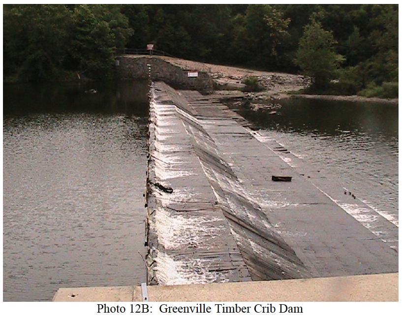
The project is comprised of an impoundment, timber crib dam, fish passage facilities, gatehouse, a canal, canal spillway, the Second Street powerhouse located at the canal end and additional powerhouse, known as the Tenth Street Station, located approximately 800 feet downstream from the canal headworks.
The gatehouse, canal, canal spillway, and powerhouse are located along the west bank. The Eight Street Bridge spans the canal and river approximately halfway between the dam and the Second Street powerhouse. The dam is of masonry and timber construction, with a spillway length of 399 feet and a flashboard height of 1.3 feet. The gatehouse is separated from the dam by masonry-lined earth fill embankment and has six timber gates, each approximately 11 feet wide by nine feet high, which admit water to the canal.
The canal is earth lined, approximately 3,200 feet in length, 70 feet wide and 13 feet deep. The canal runs parallel to the river. The canal spillway is constructed of concrete, masonry and timber material. There are twelve concrete formed spillway sections, each approximately 7.7 feet wide. The spillway crest elevation is approximately 19 feet (USGS datum), with an additional two feet of stop logs in each section.
The Second Street powerhouse is located at the end of the canal, approximately 3,200 feet downstream of the dam. The Second Street powerhouse contains two vertical Francis turbines with a total installed capacity of 0.8 MW.
The Tenth Street powerhouse is located 800 feet downstream from the canal headworks and includes a 15-foot-deep, 30-foot-wide by 80-foot-long concrete intake flume. The powerhouse containing one horizontal Kaplan turbine/generator unit with an installed capacity of 1.4 MW and a short tailrace discharging into the bypass reach.
The project operates in a run-of-river mode and impounds an 80-acre reservoir. The project provides a continuous minimum flow of 250 cfs through spillway flashboard notches and the fish passage facilities from combined flows of 100 cfs through the upstream fish passage system; 50 cfs through the downstream fish passage system; and 100 cfs through flashboard notches across the dam. This flow regime was developed in consultation with the Connecticut Department of Energy and Environmental Protection (CTDEEP) and USFWS.
Waters within the project reach are listed as impaired for recreation due to bacteriological contamination in the downstream reach. The likely cause of the impairment are illicit discharges, stormwater runoff, or sewer overflows. CTDEEP has confirmed that the project operates in a manner that does not adversely impact water quality.
Resident fish species of the Shetucket River include American shad, river herring, gizzard shad, hickory shad, striped bass, sea-run brown trout, sea lamprey, white perch, pickerel, smallmouth and largemouth bass, bluegill, rainbow smelt, and American eel. The upstream fish passage facility consists of an automated fish elevator system with an associated attraction water system. The elevator system is comprised of a 43.5-foot-long by 8-foot-wide lower entrance and collection chamber and a 58-foot-long, 8-foot-wide elevated exit flume. The elevated flume is equipped with a floor attraction water screen, trapping facilities, attached viewing room and a maintenance gate for dewatering. Attraction flow is supplied through a series of pipes from the headpond and exit flume. The system has been operational since 1996.
An upstream eel ladder is attached to the upstream fish passage system. The eel ladder consists of an elevated 20-inch-wide aluminum trough with a strip drain interior surface and aluminum cover plate. Water for the eel ladder is supplied by a submersible electric pump located within a vertical standpipe near the fish ladder exit flume. The system has been operational since 2003.
The downstream fish passage facility consists of a 1-inch clear-spaced angled bar racks, entrance chamber, buried transport pipe and submerged plunge pool. The angled bar rack is approximately 85 feet in length and 17 feet high and equipped with an automated rack cleaning system. The entrance chamber is approximately 9.5 feet long, 4 feet wide and 9.5 feet deep and equipped with a downward opening entrance flow control gate. A 36-inch buried steel transport pipe connects to the downstream end of the entrance chamber and discharges into the bypass reach. The riverbed directly beneath the transport pipe has been excavated to form a deep plunge pool into the 3,200-foot-long bypass reach. The system has been operational since 1995 and CTDEEP has concluded that passage measures at the project are effective.
The project lands consist of roughly 5.3 acres. The area surrounding the project is primarily developed with industrial, commercial, and urban residential land use. Native grasses and herbaceous growth can be found in the project area, but no lands of significant ecological value are located in the project vicinity.
Threatened or endangered species potentially present in the project vicinity include the Northern Long-eared bat, bald eagle, and blueback herring. No critical habitats for listed species exist in the project area. Fish passage facilities minimize project impacts on the state-listed blueback herring and no project impacts are expected for bald eagles that may visit the project. United States Fish and Wildlife Service and the CTDEEP confirmed that project operation would not impact any protected species.
Cultural resources in the project area include the Greenville dam which is eligible for listing on the National Register of Historic Places as part of the Greenville Industrial Historic District. Consultation with the State Historic Preservation Office is required prior to any planned ground disturbance. The project has implemented a dam repair and maintenance program to maintain the structural integrity of the dam using materials similar to the structures being replaced.
Recreational resources at the project include a canoe portage. Public access is provided free of charge.
Compliance Status
There are no facility-specific conditions in the current Certificate.
2026: No material changes or compliance issues were identified. The project remains in compliance based on the annual review.
2025: No material changes or compliance issues were identified. The project remains in compliance based on the annual review.
2024: No material changes or compliance issues were identified. The project remains in compliance based on the annual review.
2023: No material changes or compliance issues were identified. The project remains in compliance based on the annual review.
2022: No material changes or compliance issues were identified. The project remains in compliance based on the annual review.
2021: There were no reported changes or compliance issues. The project remains in compliance based on the annual review.
2020: There were no reported changes or compliance issues. The project remains in compliance based on the annual review.
2019: The project reported replacement of canal cross rack grates to improve flows in the canal. The project remains in compliance based on the annual review.
2018: Annual reporting for the current Certificate has not yet taken effect.
Certification History
January 1, 2022: The LIHI Certificate term has been extended in accordance with Revision 2.05 of the LIHI 2nd Edition Certification Handbook issued January 1, 2022. Refer to the facility table above for the new term.
July 13, 2018: The 30-day appeal window for the preliminary certification decision of the Greenville Hydroelectric Project closed on July 12, 2018 with no appeals to the decision received. The decision is therefore final and the Greenville Hydroelectric Project is recertified for a term from March 6, 2018 through March 5, 2023.
June 12, 2018: On June 11, 2018, the Greenville Project received preliminary approval for a new 5-year term of Low Impact Certification.
This decision is preliminary pending the 30-day appeal window. Only those who commented in the initial application 60-day comment period are eligible to file an appeal. Such appeal needs to include an explanation as to how the projects do not meet the LIHI criteria. Appeal requests can be submitted by email to comments@lowimpacthydro.org with “Greenville Hydroelectric Project” in the subject line, or by mail addressed to the Low Impact Hydropower Institute, 329 Massachusetts Ave, Suite 2, Lexington, MA 02420. All requests will be posted to the website and the applicant will have an opportunity to respond and any response will also be posted. Requests must be received by 5 pm Eastern time on July 12, 2018. The full application and reviewers report are available at the bottom of this page. If no appeal requests are received and the decision becomes final, the new term for the Greenville Project will be March 6, 2018 through March 5, 2023.
June 11, 2018: The Greenville Project certification term has been extended to July 15, 2018.
February 28, 2018: The Low Impact Hydropower Institute has received a complete application for a new term of Low Impact Certification for the Greenville Hydroelectric Project. The Project is located in Norwich, CT on the Shetucket River approximately 1.3 river miles above the confluence with the Thames River and approximately 1.5 river miles below its confluence with the Quinebaug River. LIHI is seeking public comment on this application. Specifically, we are interested in knowing whether you think the Project meets the LIHI Low Impact Certification Criteria, as revised in the 2nd Edition Handbook. Please review the program and criteria in LIHI’s revised Handbook and then review the Project’s 2018 application materials posted below. Comments that are directly tied to specific LIHI criteria (flows, water quality, fish passage, etc.) will be most helpful, but all comments will be considered. Comments may be submitted to the Institute by e-mail at comments@lowimpacthydro.org with “Greenville Comments” in the subject line, or by mail addressed to the Low Impact Hydropower Institute, 329 Massachusetts Avenue, Suite 2, Lexington, MA 02420. Comments must be received at the Institute on or before 5 pm Eastern time on April 29, 2018 to be considered. All comments will be posted to the web site and the applicant will have an opportunity to respond. Any response will also be posted.
February 27, 2018: The Greenville Project certification term has been extended to May 31, 2018.
May 28, 2013: The Greenville Hydroelectric Project has been certified as low impact for a five year term, effective March 6, 2013 and expiring March 6, 2018.
May 6, 2013: Public comment period on application has closed.
March 6, 2013: Norwich Public Utilities has submitted an application for the certification of its Greenville Hydroelectric Project; application has been posted and public comment period has opened.
Certification Files
2018 Recertification
2013 Certification
- Greenville Certification Questionnaire 2012
- Greenville Certification Review Report 2013
- Application Attachment – Water Quality
- Application Attachment – Fish Passage
- Application Attachment – Shoreline Protection
- Application Attachment – Threatened & Endangered Species
- Application Attachment -Cultural Resources Management Plan
- Application Attachment – Recreation
- Application Attachment – Basin Map
- Application Attachment 12