LIHI Certificate #203 - Skelton Project, Maine
| Project Name | Skelton |
| LIHI Certificate No. |
203 |
| LIHI Certificate Term |
March 5, 2025 – March 4, 2035 |
| Owner | Brookfield White Pine Hydro, LLC (a subsidiary of Brookfield Renewable Energy Group) |
| State | Maine |
| Location | River Mile 16 – Saco River |
| Installed Capacity | 21.6 MW |
| Average Annual Generation | 108,204 MWh |
| Facility Type | Seasonally modified run-of-river |
| FERC No. | P-2527. license issued in 1988, expires 01/31/2038. |
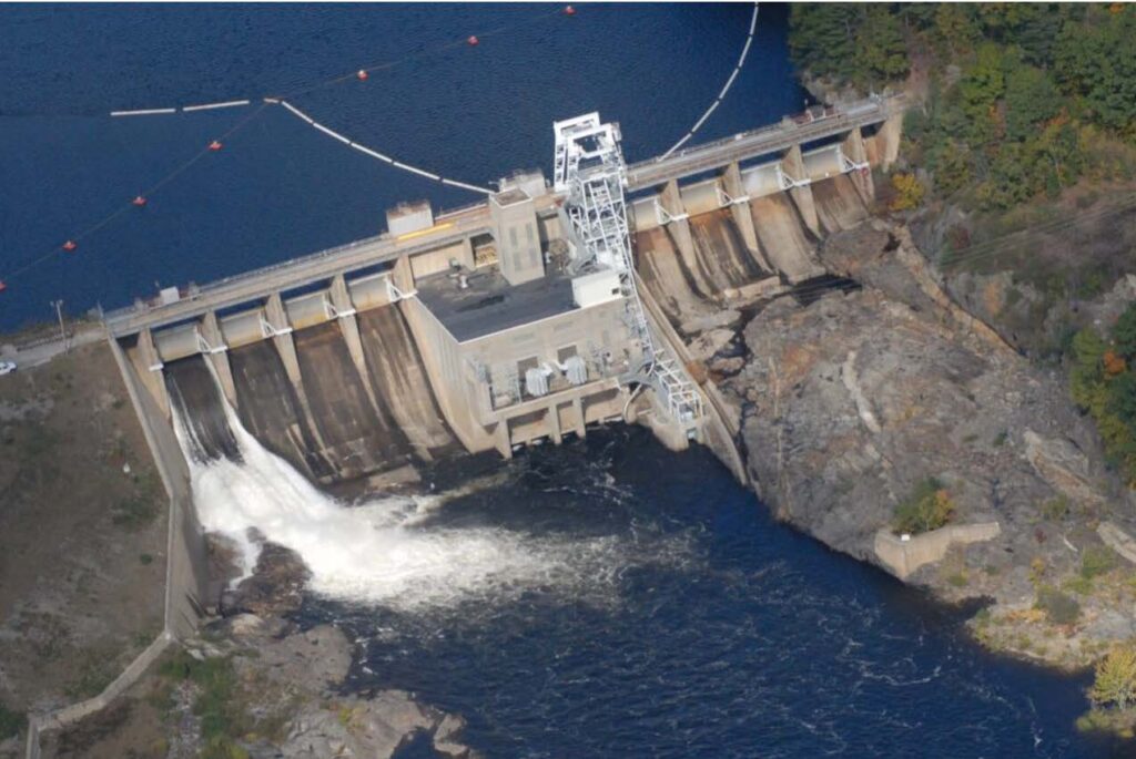
The Skelton Project (FERC No. 2527) is located on the Saco River in York County, Maine, about 11.1 river miles above the head-of-tide at Saco and 16 river miles from the mouth of the river at Camp Ellis/Hills Beach. The Project dam and powerhouse are located in the Towns of Buxton and Dayton, Maine. The impoundment is located in the Towns of Buxton, Dayton, and Hollis. The Project is the second dam on the Saco River and one of seven hydroelectric projects located on the main stem of the river.
The Project consists of a 1,695-foot-long concrete gravity and earth embankment dam topped with a roadway and was originally constructed from 1947-1949. The dam consists of: (1) an earthen embankment section, 1,200 feet long by 59 feet high, with a crest elevation of 143.0 feet (USGS); (2) a west bulkhead and spillway gate section, about 170 feet long by 75 feet high, surmounted with four Tainter gates, each 32.5 feet wide by 20 feet high, with a sill elevation of 108.0 feet (USGS); (3) an intake structure, 107 feet long by 146 feet wide, has two inflow openings, protected by trashracks of 5/8-inch steel bars at 3-inch openings; (4) a fishway and sluice section, about 30 feet long; (5) an east bulkhead and spillway gate section, about 188 feet long by 75 feet high, surmounted with four Tainter gates, each 32.5 feet wide by 20 feet high, with a sill elevation of 108.0 feet (USGS); and (6) a concrete retaining wall, traversing along the western embankment about 763 feet long, with a crest elevation of 143.0 feet (USGS).
The dam forms a riverine impoundment approximately 2.8 miles long and up to 0.2 miles wide. The impoundment includes approximately 2.1 miles of Cook’s Brook at its confluence with the Saco River. The project boundary extends upstream to the Bar Mills Project (FERC No. 2194) tailwater and extends downstream to the impoundment of the Cataract Project, LIHI #169. Farther upstream is the Bonny Eagle Project (LIHI #182).
The powerhouse is integral to the dam which creates a 488-acre impoundment. The powerhouse contains 2 vertical-shaft Kaplan turbine/generator units with a total generator capacity of 21.6 MW. The project is operated as a seasonally modified run-of-river facility. Operation of the project is managed in conjunction with the water flow and storage of upstream projects in accordance with the 1997 Saco River Instream Flow Agreement, as follows:
- April 1 through June 30, the project is operated in run-of-river mode with only 1 foot of fluctuation from the normal full pond allowed.
- July 1 through September 30, the minimum flow increases to 400 cfs when inflow is greater than 400 cfs. When inflow falls below 400 cfs the project continues to release 400 cfs by drawing from impoundment storage, with the impoundment drawdown limited to 4 feet or less from full pond elevation. Once the impoundment elevation drops 4 feet below full pond elevation outflow is equal to inflow.
- October 1 through November 15 (subject to agency approved alternative 6-week span), the minimum flow increases to 600 cfs or inflow, whichever is less.
- November 15 through March 31, the minimum flow is 400 cfs when inflow is greater than 400 cfs. When inflow falls below 400 cfs the project continues to release 400 cfs by drawing from impoundment storage, with the impoundment drawdown limited to 4 feet or less from full pond elevation. Once the impoundment elevation drops 4 feet below full pond elevation outflow is equal to inflow.
The Saco River in the project vicinity is a Class A water, suitable for the designated uses of drinking water after disinfection; fishing; agriculture; recreation in and on the water; industrial process and cooling water supply; hydroelectric power generation, and as habitat for fish and other aquatic life. The river in the project vicinity is not listed as impaired. Water quality monitoring had been conducted and Maine DEP confirmed that the project is in compliance with it water quality certification.
The project is equipped with upstream and downstream fish passage facilities installed in 2001. Upstream fish passage is provided by a fish lift located on the south side of the powerhouse, and consists of an attraction water system, a fish crowder system, a hopper/elevator, and truck and trap holding systems. Downstream fish passage is provided by a concrete log sluice centrally located in the dam equipped with a 5-foot by 5-foot slide gate located at the headworks. The project also has an upstream eel passage that was first operational in 2013. It includes a roughened cement attraction water flow area on the East side of the Skelton spillway leading the juvenile eels to a three-foot long EnkaMat ramp and into an elevator tank with approximately 50-gallon capacity. The project conducts nighttime shutdowns during the eel downstream passage season.
Lands around the project are primarily forested or under agricultural use. There are no lands of ecological significance. Run-of-river operations and limited impoundment fluctuations serve to limit erosion and serves to benefit existing wetlands and wildlife.
Threatened or endangered species that may be present include small whorled pogonia and Blanding’s turtle (state endangered). Other species proposed for listing include tri-colored bat and monarch butterfly. Other bats may also be present including the state endangered little brown bat and Northern long-eared bat (also federally endangered), and the state threatened Eastern small-footed bat. Bald eagles and other migratory birds may also be present on a periodic basis. Four rare plant species adjacent to the project boundary: hollow joe-pye weed; spotted wintergreen; hairy wood brome-grass; and American chestnut. Project operations are unlikely to adversely affect any protected species because vegetation removal within 250 feet of any waterway is regulated by the Maine DEP Shoreline Zoning Act and the project does not typically need to cut trees or engage in more impactful land-based activities.
Four archaeological sites exist in the project area that are eligible for inclusion in the National Register of Historic Places. The FERC License requires implementation of the 1993 Programmatic Agreement to protect these resources. A review of the annual reports required by Article 415 for the previous 10 years did not indicate any cultural or historic resource issues at the Project.
Recreational amenities at the project include a boat launch area on the western shore just upstream of the dam that additionally serves as a portage take-out, and a portage trail with a put-in on the western shore downstream of the tailrace. Recreational facilities are available free of charge.
Compliance Status
The Certificate includes the following facility-specific conditions:
Condition 1: The Facility Owner must submit to LIHI the results of its 2025 upstream passage effectiveness studies and documentation of agency comments on the study results within 90 days of final report publication. In subsequent annual compliance submittals, copies of all consultation and filings related to any passage modifications required as a result of the effectiveness studies must be provided to LIHI. LIHI reserves the right to modify or add conditions, and to re-evaluate compliance with the upstream passage criterion based on the information provided.
Condition 2: The Facility Owner must file the results of its 2025 and 2026 downstream passage effectiveness studies and documentation of agency comments on the study results in quarterly compliance updates to LIHI until studies are completed. In subsequent annual compliance submittals, copies of all consultation and filings related to any passage modifications required as a result of the effectiveness studies must be provided to LIHI. LIHI reserves the right to modify or add conditions, and to re-evaluate compliance with the upstream passage criterion based on the information provided.
2026: No material changes or compliance issues were identified. The project remains in compliance based on the annual review. For Condition 1, the project submitted draft alosine passage study results to agencies and is awaiting comments. A study plan for 2026 will be developed. For Condition 2, the project reported that the 2025 downstream eel study was postponed due to insufficient numbers of available fish, but a smaller pilot study was conducted. Results were submitted to agencies and the project is awaiting their comments.
2025: Annual reporting for the current Certificate has not yet taken effect.
Certification History
August 6, 2025: The Low Impact Hydropower Institute has issued a final decision on the certification of the Skelton Hydroelectric Project. No appeals were received during the appeal period which closed on July 31, 2025. The 10-year certification term is March 5, 2025 to March 4, 2035.
July 1, 2025: The Low Impact Hydropower Institute has preliminarily approved Low Impact Certification for the Skelton Hydroelectric Project, (pending LIHI #203). The full application and reviewer’s report are available below. This decision is preliminary pending the 30-day appeal window. Only those who commented on the initial applications during the 60-day comment period are eligible to file an appeal. Such appeal needs to include an explanation as to how the Projects do not meet the LIHI criteria. Appeal requests can be submitted by email to mailto:comments@lowimpacthydro.org with “Skelton Project” in the subject line, or by mail addressed to the Low Impact Hydropower Institute, 68 Harrison Ave Ste 605, PMB 113938 Boston, Massachusetts 02111-1929. All requests will be posted to the website. The applicant will have an opportunity to respond and any response will also be posted. Requests must be received by 5 pm Eastern time on July 31, 2025. If no appeal requests are received the certification term will be March 5, 2025 through March 4, 2035.
March 6, 2025: The Low Impact Hydropower Institute has received a complete application for Low Impact Certification of the Skelton Hydroelectric Project. LIHI is seeking public comment on this application. Specifically, we are interested in knowing whether you think the Project meets the LIHI Low Impact Certification Criteria, as revised in the 2nd Edition Handbook in effect at the time of initial applicaton. Please review the program and criteria in LIHI’s Handbook Revision 2.05, and then review the Project’s application materials below. Comments that are directly tied to specific LIHI criteria (flows, water quality, fish passage, etc.) will be most helpful, but all comments will be considered. Comments may be submitted to the Institute by e-mail at comments@lowimpacthydro.org with “Skelton Project Comments” in the subject line, or by mail addressed to the Low Impact Hydropower Institute, 68 Harrison Ave Ste 605, PMB 113938 Boston, Massachusetts 02111-1929. Comments must be received on or before 5 pm Eastern time on May 5, 2025 to be considered. All comments will be posted to the web site and the applicant will have an opportunity to respond. Any response will also be posted.
Certification Files
2025 Application
- Skelton Certification Review Report 2025
- Skelton LIHI Application
- TU Comments
- TU Followup Comments
- Brookfield Response to TU Comments
- 2024 Saco River Diadromous Fish Passage Report