LIHI Certificate #186 - Lower La Chute Project, New York
| Project Name | Lower La Chute |
| LIHI Certificate No. | 186 |
| LIHI Certificate Term | August 5, 2021 – August 4, 2031 |
| Owner | La Chute Hydro Company, LLC, a subsidiary of LS Power/ Patriot Hydro, LLC |
| State | New York |
| Location | Located at river mile 1.9 on the La Chute River in Ticonderoga, Essex County, NY |
| Installed Capacity | 3.6 MW |
| Average Annual Generation | 13,800 MWh |
| Facility Type | Run-of-river |
| FERC No. | P-5762 exempt 1984 |
The Lower La Chute Project and the Upper La Chute Hydroelectric Project (LIHI #185) are both located on the La Chute River, in the Village of Ticonderoga, Essex County, New York. The La Chute River carries flow from Lake George to Lake Champlain and is approximately 2.5 miles long.
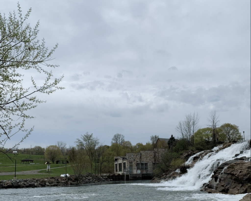
The Lower La Chute Project uses the headwaters formed by the Mill D dam of the Upper La Chute Project. The dam is the fourth in a series of six dams along the river and is located about 4,100 feet downstream of the Mill A dam (part of the Upper Project). The Lower Project uses flows from the Upper La Chute and from Trout Brook. The Lower La Chute project operates as run-of-river and has a headpond with 2.3 acres of surface area with negligible storage. Flows from the D-Mill dam are conveyed by a 9-foot diameter penstock to the powerhouse, located below the falls at Mill F dam. The dam creates a bypassed reach approximately 0.36 miles long. The powerhouse has a single turbine-generator unit rated at 3,600 kW. The Lower Project is accessible from Interstate 87, State Route 9N and local streets.
The Upper La Chute Project dictates operations of the Lower La Chute Project. The Upper La Chute Project operates in run-of-river mode and dictated by flow releases from Lake George which are regulated by New York State statute and the New York State Department of Environmental Conservation. A 30-cfs minimum flow is provided in the bypassed reach.
Waters within the project reach are designated as Class C(TS) in the bypassed reach, and Class C in the tailwater reach. Class C waters are best used for fishing. The application of (TS) indicates that the classifications are supportive of trout populations.
The La Chute River in the project vicinity supports a mix of warmwater and coldwater fish species. Of these, several migratory species are found at the project including blueback herring, alewife, American eel, lake sturgeon, landlocked Atlantic salmon, and sea lamprey. Atlantic salmon are maintained via stocking and American eel are similarly supported via stocking. Blueback herring, alewife, and sea lamprey are considered non-native or invasive and thus pose a threat to native species, especially trout and salmon. Passage is not desirable for these species as they could negatively impact native fish populations in Lake George. Downstream passage is provided by a weir at the Upper La Chute Mill D, and Mill F allows for a natural water fall which does not specifically provide formal downstream passage but rather an unobstructed flow downstream.
The project lands consist of just under 500 acres encompassing both the Upper La Chute and Lower La Chute projects. The shoreline in the project vicinity is a mix of deciduous and evergreen forest with residential and commercial properties with ornamental grasses. Some agrarian fields and wetlands are also found in the area. The 1992 Lake George Dam Operating Guidelines for the Upper La Chute Hydroelectric Project provides specific provisions regarding the management of water levels in the Lake George watershed.
Threatened or endangered species potentially present in the project vicinity include the Indiana bat and Northern long-eared bat. No critical habitats for either species are found in the project vicinity. Other listed plant and bird species are listed as potentially present though the project does not operate in or impact areas where these species may be found.
Consultation with the State Historic Preservation Office concluded that project operations do not have an adverse impact on historical or cultural resources in the area. Additionally, the Lower powerhouse was constructed to keep with the historical nature of the Village of Ticonderoga, designed to blend in with the Village’s historical architecture.
Recreational resources at the project include a handicap accessible fishing platform at the Lower bypass along with a paved boat ramp with gravel parking located across the river. Since the FERC exemption does not require these facilities, they are provided voluntarily. The tailwater reach is home to Bicentennial Park which was built in cooperation with the project owner and includes a boat launch, walking trail, day use areas, and a handicap accessible fishing area. Public access is provided free of charge.
Compliance Status
There are no facility-specific conditions in the current Certificate
2025: No material changes or compliance issues were identified. The project remains in compliance based on the annual review.
2024: No material changes or compliance issues were identified. The project remains in compliance based on the annual review.
2023: No material changes or compliance issues were identified. The project remains in compliance based on the annual review.
2022: No material changes or compliance issues were identified. The project remains in compliance based on the annual review.
2021: Annual reporting for the current Certificate has not yet taken effect.
Certification History
January 1, 2022: The LIHI Certificate term has been extended in accordance with Revision 2.05 of the LIHI 2nd Edition Certification Handbook issued January 1, 2022. Refer to the facility table above for the new term.
December 14, 2021: The Low Impact Hydropower Institute has issued a final decision on the certification of the Lower La Chute Project. The 30-day appeal window closed on December 4, 2021 and no appeals were filed. Therefore, the decision to certify the project is now final. The new term is August 5, 2021 through August 4, 2026.
November 4, 2021: The Low Impact Hydropower Institute (LIHI) has preliminarily approved the Upper and Lower La Chute Projects for 5-year terms of Low Impact Certification. This decision is preliminary pending the 30-day appeal window. Only those who commented on the initial application during the 60-day comment period are eligible to file an appeal. Such appeal needs to include an explanation as to how the Project does not meet the LIHI criteria. Appeal requests can be submitted by email to comments@lowimpacthydro.org with “Upper and Lower La Chute Projects” in the subject line, or by mail addressed to the Low Impact Hydropower Institute, 1167 Massachusetts Ave, Office 407, Arlington, MA 02476. All requests will be posted to the website. The applicant will have an opportunity to respond and any response will also be posted. Requests must be received by 5 pm Eastern time on December 4, 2021. The full application and reviewer’s report are available below. If no appeal requests are received and the decision becomes final, the Certification term for each Project will be August 5, 2021 through August 4, 2026.
August 5, 2021:The Low Impact Hydropower Institute has received a complete application for Low Impact Certification of the La Chute Upper and Lower Projects. LIHI is seeking public comment on this application. Specifically, we are interested in knowing whether you think the Project meets the LIHI Low Impact Certification Criteria, as revised in the 2nd Edition Handbook. Please review the program and criteria in LIHI’s revised Handbook and then review the Project’s application materials below. Comments that are directly tied to specific LIHI criteria (flows, water quality, fish passage, etc.) will be most helpful, but all comments will be considered. Comments may be submitted to the Institute by e-mail at comments@lowimpacthydro.org with “La Chute Project Comments” in the subject line, or by mail addressed to the Low Impact Hydropower Institute, 1167 Massachusetts Avenue, Arlington, MA 02476. Comments must be received on or before 5 pm Eastern time on October 4, 2021 to be considered. All comments will be posted to the web site and the applicant will have an opportunity to respond. Any response will also be posted.
Certification Files
2021 Certification
- La Chute Upper and Lower Projects Certification Review Report
- La Chute Upper and Lower Projects Application 2021
- La Chute Agency and Stakeholder Contacts