Pending Application - Hawks Nest Project, West Virginia
| Project Name | Hawks Nest |
| LIHI Certificate No. |
n/a |
| LIHI Certificate Term |
n/a |
| Owner | Hawks Nest Hydro LLC, a subsidiary of Brookfield Renewable Energy Group |
| State | West Virginia |
| Location | River Mile 6.9 on the New River, Fayette County |
| Installed Capacity | 102 MW |
| Average Annual Generation | 529,000 MWh |
| Facility Type | Run-of-river |
| FERC No. | P-2512 issued in 2017, expires 01/31/2064 |
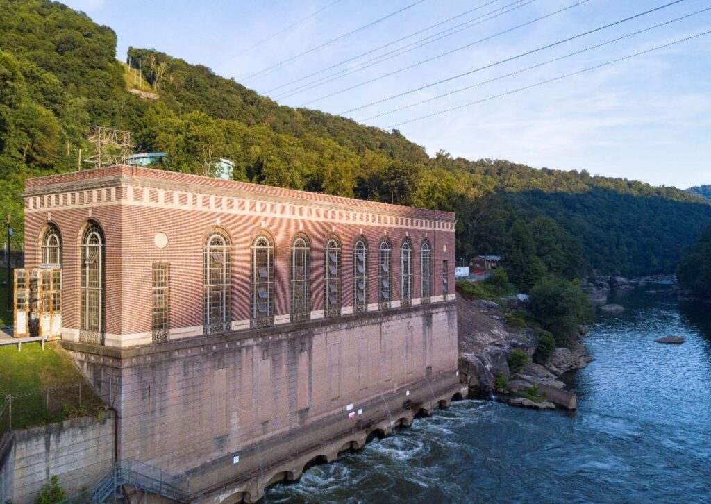
The Hawks Nest Project is the fifth dam upstream from the mouth of the New River and located between the towns of Ansted and Gauley Bridge, West Virginia. The three most downstream dams on the river are locks and dams operated by the US Army Corps of Engineers (USACE). The 260-mile-long New River originates in North Carolina at the confluence of the North Fork and South Fork New Rivers, then flows northward for 171 miles through Virginia before entering West Virginia.
Most of the New River between the upstream USACE Bluestone Dam at river mile 66.2 and Hawks Nest Dam at river mile 6.9 is encompassed within the 72,186-acre New River Gorge National Park and Preserve. At over 1,000 feet deep, the dramatic New River Gorge is a prominent physiographic feature, though numerous striking geological features such as exposed cliffs, rock cities, massive boulders, rock overhangs, exposed coal bearing sediments, and unusual formations caused by spheroidal weathering also characterize this segment of the river.
The project consists of:
- a 948-foot-long concrete spillway dam with a maximum height of 90 feet and with 14 spillway bays, each with a 25-foot by 50-foot steel crest gate;
- a reservoir with a surface area of 243 acres at normal surface elevation;
- a concrete intake structure with trashracks, located at the west abutment;
- a 16,240-foot-long tunnel;
- a 600-foot-long by 170-foot-wide surge basin and a 116-foot-diameter surge tank;
- a 107-foot-long, 30-foot-diameter steel penstock;
- a manifold connection leading to five 14-foot-diameter steel penstocks varying in length from 42 feet to 132 feet (one of the five penstocks is not being used);
- a concrete powerhouse with four identical 25.5-MW, 25-Hz turbine/generator units; and
- transmission infrastructure and appurtenant facilities.
The dam creates a bypassed reach 5.4 miles long and the powerhouse is located just 1.5 miles upstream from the confluence of the New and Gauley Rivers where these rivers merge to form the Kanawha River.
The project operates in a run-of-river mode with the reservoir level maintained through power generation and release of the required minimum flow of 300 cubic feet per second (cfs) from March 1 through June 30, and 250 cfs for all other months. Minimum flows are delivered via the trash gate at the right end of the spillway and additional spill through the spillway gates when inflow exceeds powerhouse capacity. A ramping rate limited to 1 foot per hour is required from March through October when river flows are less than 12,600 cfs, and when there are flows of 2,600 cfs or less in the bypass reach.
The impoundment is considered a “Tier 3 water” indicating outstanding national resource water. These designated waters include those in Federal Wilderness Areas, specifically designated federal waters, and high-quality waters or naturally reproducing trout streams in state parks, national parks, and national forests. The bypassed reach and downstream reach are classified as a warm water fishery with additional designated uses for agriculture and wildlife, and for industrial water supply, transport, cooling and power generation uses. The bypassed and downstream reach, like all of the river downstream of the dam, is impaired for fecal coliform due to numerous wastewater discharges in the lower watershed.
There are no migratory fish species in the New River. The Kawana Falls located downstream of the project at the Glen Ferris project preclude migratory fish from upstream habitats. However, three potamodromous species have been found historically within or near the project boundary include channel catfish and the non-native hybrid striped base and alewife. Numerous resident fish species are present, and the New River supports an exceptional smallmouth bass fishery. There are no fish passage requirements and while downstream passage survival was determined to be high, there is some entrainment and the project owner provides annual fish compensation payments to the West Virginia Division of Natural Resources.
Project lands encompass 1,072 acres, including the 243-acre impoundment, 209 acres of water in the bypassed and downstream reaches, and about 620 acres of land which is primarily undeveloped forest. A large portion of the project is surrounded by the New River George National Park & Preserve, Hawks Nest State Park, and the Cotton Hill Wildlife Management Area.
West Virginia does not designated state-listed threatened or endangered species. Federally listed or proposed for listing species that are or may be present include five species of bats, nine species of freshwater mussels, the Virginia spirea (historical observations only) and monarch butterfly. The formerly listed running buffalo clover is also present and the project owner implements a management plan for that species. The project limits tree removal during bat roosting seasons. It has been determined that the project does not negatively impact mussels or Virginia spirea.
There are no federally recognized Indian Tribes in West Virginia. The state of West Virginia has no state
recognized tribes, or an office to manage Indian affairs. The project owner consulted with nine federally recognized Indian tribes in the development of the project’s Historic Properties Management Plan and has consulted with Indian Tribes to identify additional information regarding properties of traditional religious or cultural significance that may be located within the Project’s affected area. The project was built in the 1930s by the New-Kanawha Power Company, a subsidiary of Union Carbide and Carbon Corporation, to provide 25-hertz (Hz) power for the smelter furnaces at the Union Carbide ferroalloy plant near Alloy, West Virginia. The Project has been deemed eligible for the National Register of Historic Places, both as an outstanding engineering achievement, and for its association with the industrial events related to its construction, including the Hawks Nest Tragedy which occurred during construction.
The project operates under a recreation management plan. Recreation facilities include the Hawks Nest Tailrace Fishing Access, a day-use facility located adjacent to the Hawks Nest powerhouse. The Cotton Hill area provides public recreational access to the upper Hawks Nest bypass reach and supports hiking, rock climbing, wildlife observation, and fishing access, as well as multi-use pedestrian trails which also serve as put-in locations for boater access to the bypass reach. The state Cotton Hill Wildlife Management Area also allows hunting and trapping. There is also a dam portage, bike/hike trail and a day use area. The project operates under a flow release plan and the owner maintains a public flow notification website for the Hawks Nest Project. The website provides an annual schedule for nine recreation flow releases.
Certification History
January 15, 2026 The Low Impact Hydropower Institute has received a complete application for Low Impact Certification of the Hawks Nest Hydroelectric Project. LIHI is seeking public comment on this application. Specifically, we are interested in knowing whether you think the Project meets the LIHI Low Impact Certification Criteria, as revised in the 2nd Edition Handbook in effect at the time of initial application. Please review the program and criteria in LIHI’s Handbook Revision 2.06 and then review the Project’s application materials below.
Comments that are directly tied to specific LIHI criteria (flows, water quality, fish passage, etc.) will be most helpful, but all comments will be considered. Comments may be submitted to the Institute by e-mail at comments@lowimpacthydro.org with “Hawks Nest Project Comments” in the subject line, or by mail addressed to the Low Impact Hydropower Institute, 68 Harrison Ave Ste 605, PMB 113938 Boston, Massachusetts 02111-1929. Comments must be received on or before 5 pm Eastern time on March 16, 2026 to be considered. All comments will be posted to the web site and the applicant will have an opportunity to respond. Any response will also be posted.