LIHI Certificate #198 - Hailesboro No. 4 Project, New York
| Project Name | Hailesboro No. 4 |
| LIHI Certificate No. |
198 |
| LIHI Certificate Term |
February 3, 2023 – February 2, 2033 |
| Owner | Hydro Development Group Acquisition, LLC – a subsidiary of Patriot Hydro. LLC |
| State | New York |
| Location | River mile 67.7 on the Oswegatchie River, St. Lawrence County, New York |
| Installed Capacity | 1.9 MW |
| Average Annual Generation | 10,647 MWh |
| Facility Type | Run of river |
| FERC No. | P-6058. Issued in 2002, expiring 12/31/2032. |
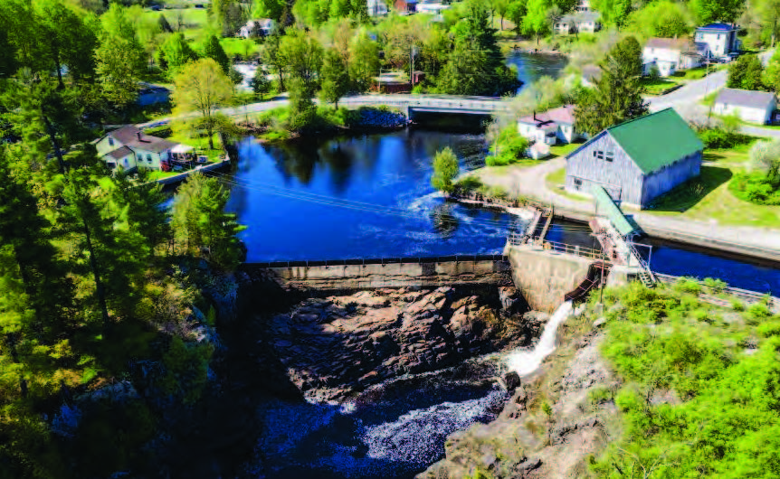
The Hailesboro No. 4 Project (FERC No. 6058) is located on the Oswegatchie River in St. Lawrence County, New York. The 132-mile long Oswegatchie River is located in the St. Lawrence River watershed. The headwaters of the Oswegatchie River are in the Adirondack Mountains and the river flows generally to the west and then north before flowing into the St. Lawrence River in Ogdensburg, New York.
The project is located at river mile (RM) 67.7 and is the 7th dam upstream from the mouth, and the most downstream of three associated projects that also include Hailesboro No. 3 (LIHI #197) and Hailesboro No. 6 (LIHI #199). The river is split into three branches upstream of Hailesboro No. 6 (Island Branch) and between the Projects that recombine downstream of Hailesboro No. 3.
The project was originally constructed in 1936 and operates under a license issued by the Federal Energy Regulatory Commission on October 30, 2002 which was amended on September 19, 2012, and expires December 31, 2032.
The project consists of:
- a concrete gravity-type dam comprised of the 105-foot-long, 14-foot-high dam #1 surmounted by a 2-foot-high pneumatic crest gate and the 58-foot-long, 5-foot-high dam #2 surmounted by 2-foot-high wooden flashboards;
- a reservoir with a surface area of 2 acres and a gross storage volume of 20 acre-feet at normal water surface elevation 461 ft NGVD that creates a 0.4-mile-long bypassed reach;
- a gated intake structure with steel trashracks which have 1.75-inch clear spacing;
- a 170-foot-long concrete-lined forebay canal with a sluice gate;
- a reinforced concrete and concrete masonry powerhouse containing two horizontally mounted, double runner, Francis-type turbine units; one 900-kW generating unit and one 1,000-kW generating unit for a total installed capacity of 1,900 kW;
- a 2.4/23-kV substation, a 50-foot-long, 23-kV transmission line and appurtenant facilities; and
- a 73-foot-long by 3-foot-high concrete gravity diversion dam (Island Branch Weir), topped with 1-foot-high wooden flashboards, located at the entrance of the Island Branch of the Oswegatchie River.
The Project operates in a run-of-river mode with inflow approximating outflow and minimal fluctuations in impoundment water surface elevation. Impoundment drawdowns are limited to no more than 3 inches below the top of the dam flashboards or the dam crest if flashboards are not in place. Run-of-river operations and impoundment water surface elevations are monitored in accordance with a Flow Monitoring Plan. Minimum flows of 20 cfs at Dam #1 and 8 cfs from Dam #2 are provided into the bypassed reach except during walleye spawning season when a combined minimum flow of 105 cfs must be released below the two dams. A minimum flow of 30 cfs is provided to the Island Branch via a notch in the weir. These flow levels were determined by a demonstration flow study conducted at the time of licensing and consultation with the resource agencies.
The Oswegatchie River in the vicinity of the project is designated as Class A water. The best usages of Class A waters are as a source of water supply for drinking, culinary or food processing purposes, primary and secondary contact recreation, and fishing. The project reaches are not listed as impaired by NYSDEC and run-of-river operations do not affect water quality.
There are no migratory fish in the project reaches due to the presence of several downstream dams as well as natural falls that block upstream fish movement. Resident fisheries of the Oswegatchie River in the Project vicinity consist of a mix of warm and cool water species. The most abundant species captured during the surveys were rock bass, fallfish, and pumpkinseed. The low intake approach velocity of 0.89 ft/second allows most fish to avoid entrainment in the turbines. In addition, many smaller fish that might not be able to outswim the approach velocities are often small enough to avoid turbine blade strikes and pass through a powerhouse unharmed. Additional fish protection measures included modification of the outflow of the sluice gate to minimize injury to any fish passing downstream via the 20-cfs minimum flow at Dam #1; provision of an adequate plunge pool (at least 1 foot of depth for every 4 feet of drop), a smooth surface in the bypass sluice, and adequate dispersal of flow through the sluice to provide sufficient depths for safe fish movement; and consultation with Interior and NYSDEC regarding the need for trashracks with a maximum clear spacing of 1 inch when the existing trashracks need replacement, which has not yet occurred.
Project lands encompass about 2 acres for the impoundment and about 0.5 acres surrounding the facility. There are no lands of ecological significance and no critical habitats located in the vicinity. The run-of-river operations and impoundment restrictions limit fluctuations in impoundment water surface elevation that otherwise could contribute to shoreline erosion. Erosion and sediment control measures and monitoring are followed during routine maintenance or construction activities.
The only federally threatened or endangered species that could be present in the project vicinity is the Northern long-eared bat. Several migratory birds may be present in the Project areas and include belted kingfisher, black-billed cuckoo, chimney swift, golden-winged warbler, and wood thrush. The project’s small footprint and lack of need to cut trees limit any potential impacts to these species. Only dead trees around the impoundment may be cut if they pose a hazard to navigation or project operations.
There are no known aboveground or archaeological resources listed in or eligible for listing in the National Register of Historic Places in the Project area. No traditional cultural properties have been identified. However, due to the age of the dam and powerhouse, it is possible that they could be eligible for listing, subject to determination of historical relevance. The State Historic Preservation Officer (SHPO) reviewed the project at the time of relicensing and determined that there would be no effect on cultural resources. In the event any archaeological or historic sites are found during operation and maintenance of the Project, the owner consults with the SHPO and preparation of a cultural resources management plan.
Recreational facilities include a car-top boat access in the impoundment and a parking area near the powerhouse that leads to bank fishing access at the Hailesboro No. 3 impoundment. Recreational access is provided free of charge.
Compliance Status
The Certificate includes the following facility-specific condition:
Condition 1. In annual compliance submittals to LIHI, the facility Owner shall provide updates on the status of the portage put-in downstream of the Hailesboro No. 3 Project, including outreach made to FERC and landowners regarding acquiring land adjacent to the Hailesboro No. 3 tailrace necessary to construct the portage put-in; or the Owner shall provide documentation of closure of the issue with FERC under Article 410(2) of the Hailesboro No. 4 license if a put-in at Hailesboro No. 3 is no longer relevant or necessary.
2026: No material changes or compliance issues were identified. The project remains in compliance based on the annual review. For Condition 1, the project reported ongoing discussions with an abutting landowner for river access.
2025: No material changes or compliance issues were identified. The project remains in compliance based on the annual review. For Condition 1, the project reported one of two abutting landowners who responded is not receptive to allowing portage over their property.
2024: No material changes or compliance issues were identified. The project remains in compliance based on the annual review. For Condition 1, the project reported sending letters to two landowners with no response received yet.
2023: Annual reporting for the current Certificate has not yet taken effect.
Certification History
June 6, 2023: The Certification of the Hailesboro No. 3, No. 4 and No. 6 projects is now final after the close of the appeal period on June 3, 2023, with no appeal requests filed. The certification term for each project is February 3, 2023 through February 2, 2033.
May 4, 2023: The Low Impact Hydropower Institute has preliminarily approved Low Impact Certification for the Hailesboro No. 3, No. 4 and No. 6 Hydroelectric Projects. The full application and reviewer’s report are available below. This decision is preliminary pending the 30-day appeal window. Only those who commented on the initial applications during the 60-day comment period are eligible to file an appeal. Such appeal needs to include an explanation as to how the Projects do not meet the LIHI criteria. Appeal requests can be submitted by email to comments@lowimpacthydro.org with “Hailesboro Projects” in the subject line, or by mail addressed to the Low Impact Hydropower Institute, 1167 Massachusetts Ave, Arlington, MA 02476. All requests will be posted to the website. The applicant will have an opportunity to respond and any response will also be posted. Requests must be received by 5 pm Eastern time on June 3, 2023.
February 7, 2023: The Low Impact Hydropower Institute has received a complete application for Low Impact Certification of the Hailesboro No. 3, 4, & 6 Hydroelectric Project. LIHI is seeking public comment on this application. Specifically, we are interested in knowing whether you think the Project meets the LIHI Low Impact Certification Criteria, as revised in the 2nd Edition Handbook. Please review the program and criteria in LIHI’s revised Handbook and then review the Project’s application materials below. Comments that are directly tied to specific LIHI criteria (flows, water quality, fish passage, etc.) will be most helpful, but all comments will be considered. Comments may be submitted to the Institute by e-mail at comments@lowimpacthydro.org with “Hailesboro 3, 4, & 6 Project Comments” in the subject line, or by mail addressed to the Low Impact Hydropower Institute, 1167 Massachusetts Avenue, Arlington, MA 02476. Comments must be received on or before 5 pm Eastern time on April 8, 2023 to be considered. All comments will be posted to the web site and the applicant will have an opportunity to respond. Any response will also be posted.
Certification Files
2023 Certification
- Hailesboro No. 3, 4, 6 – Certification Review Report 2023
- Hailesboro No. 3, 4, 6 – Certification Application 2022