Pending Application - Carthage Mill Project, New York
| Project Name | Carthage Mill (West End Dam) |
| LIHI Certificate No. |
n/a |
| LIHI Certificate Term |
n/a |
| Owner | Northbrook Carthage, LLC a subsidiary of Relevate Power |
| State | New York |
| Location | River Mile 32.8 on the Black River in Carthage and West Carthage, NY |
| Installed Capacity | 5 MW |
| Average Annual Generation | 21,983 MWh |
| Facility Type | Run-of-river |
| FERC No. | P-5800 exemption issued June 7, 1982 (reinstated July 11, 1983) |
The Carthage Mill (West End Dam) Hydroelectric Project is located at river mile 32.8 on the Black River in New York. The Black River is heavily regulated with 21 dams along its length and several impoundments that feed the New York State Barge Canal System. The Project is in close proximity to the Carthage Paper Maker Mills (Carthage PMM) Dam (FERC No. 10887), Tannery Island Dam (FERC No. 4908) and Long Falls Dam (FERC No. 4636). Downstream dams include the Black River/Beebee Island Project (LIHI #34) located between river mile 27.5 and river mile 9.
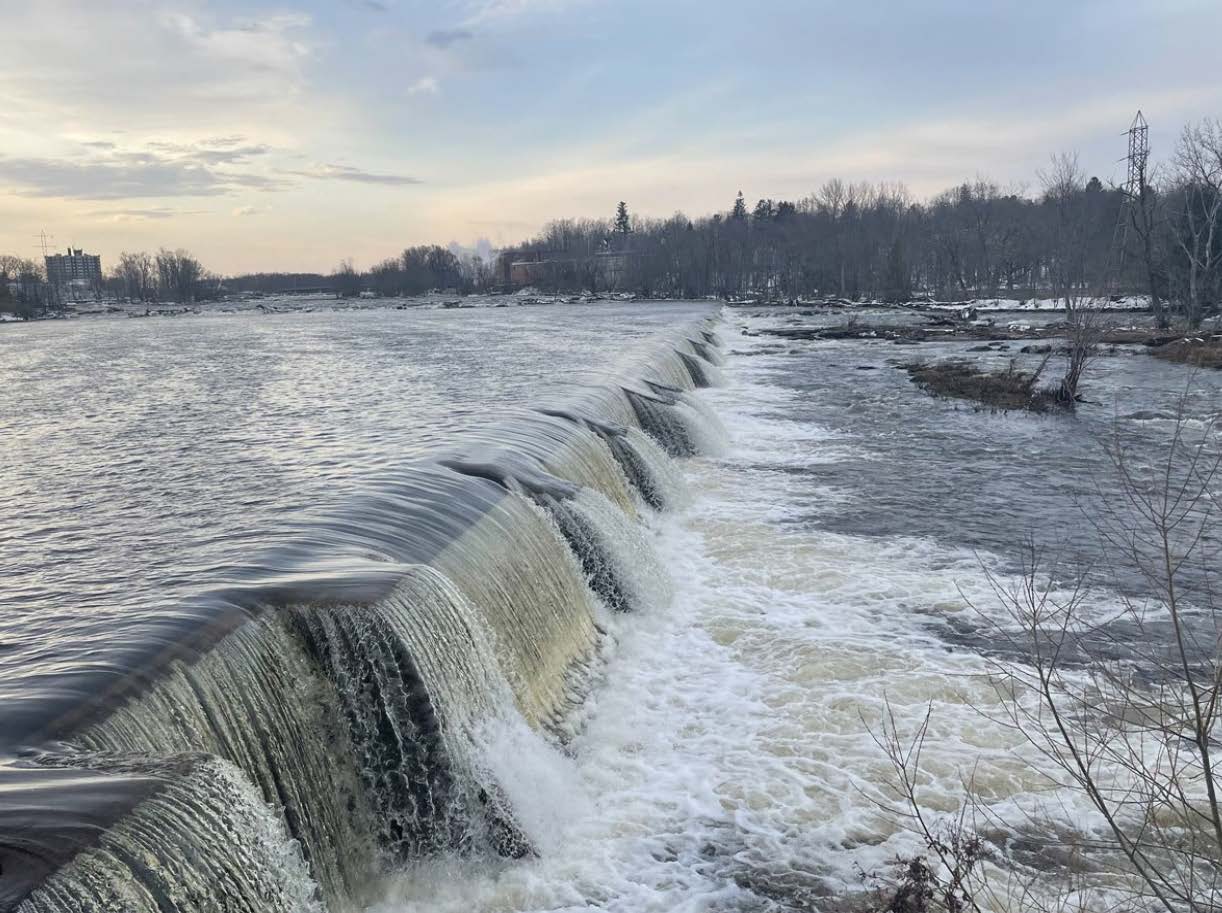
The project consists of an approximately 1,300-foot-long dam with an uncontrolled spillway, a non-overflow concrete wall section, a sluice gate, and a powerhouse with an integral intake. The dam has an 8-ft-long by 8-ft-wide sluice gate and multiple minimum flow notches. The spillway has a total of six slots measuring 8 inches deep: three 21-ft-long notches; one 15-ft-long notch, one 31-ft-long notch and one 21-ft, 6-in-long notch. The spillway does not have flashboards. The powerhouse is located at the dam, but the Carthage Mill dam and the Long Falls dam jointly create a single bypassed reach approximately 2,000 feet long.
The powerhouse intake gates measure 23 ft long by 23 ft wide and the intake trashracks are in two sections that are 21 ft long by 40 ft wide. Trashrack spacing is 3.5″ on center. The powerhouse is a concrete structure containing two turbine-generator units with a total capacity to generate 5.0 MW, and an overhead crane. The powerhouse has two units: a 2.6 MW Kaplan unit with a hydraulic capacity of 1,990 cfs and a 2.4 MW Kaplan unit with a hydraulic capacity of 1,940 cfs.
The project is a run-of- river facility and provides minimum flow determined by NYSDEC to be sufficient to support dissolved oxygen levels and aquatic habitats downstream. At Channel 1 (ice sluice), 91 cubic feet per second (cfs) is released at all times except 200 cfs is released from March 15 to May 15 for walleye spawning, including 111 cfs through the sluice gate, which is lowered 2.25 ft during this time. At Channel 2 and 3 (minimum flow notches), 79 cfs and 27 cfs are released at all times, respectively. The Long Falls Dam also discharges to the bypass reach. River flows into the Black River from upstream are regulated by the Hudson River – Black River Regulating District. The tailrace experiences a backwater effect from the Black River
Waters in the project reach are considered Class C waters which are suitable for the designated uses of: fish, shellfish and wildlife propagation and fishing and primary and secondary-contact recreation. Project waters are not listed as impaired by the State of New York.
There are no migratory fish species in the project vicinity, and barriers to migration exist well downstream in Watertown NY at the Mill Street Falls. No upstream fish passage is required or provided. Resident species include pumpkinseed, smallmouth bass, golden shiner, yellow perch, rock bass, chain pickerel and walleye. Downstream passage of these species is provided via the minimum flows and spill from the dams.
The project boundary encompasses 13 acres of water and less than one acre of land enclosing the dam and powerhouse and follows the reservoir up to the full pond elevation. There are no shoreline lands along the impoundment and lands within the project boundary below the project dam are inundated. A small parcel of uplands along the retaining wall the separates the bypass reach from the tailrace is vegetated, consisting of grass and underbrush exists on the sides of the tailrace channel. The sides of the tailrace are steep and for the most part, barren rock. Lands surrounding the project boundary are largely the developed areas of adjacent municipalities, road networks, and commercial sites. Some forested areas exist to the north and south of the project boundary, but they are generally managed lands and are bifurcated by roads and development. There are no lands of ecological significance.
The only threatened or endangered species that are or may be present are Indiana bat and northern long-eared bat (both are federally and state listed). Given the project’s small footprint and lack of potential roost trees, the project is unlikely to affect these species.
There are no documented archaeological or historic sites within the project boundary and none of the project structures are listed on the National Register of Historic Properties, although due to age some could be eligible for listing. The project owner recently reached out to federally recognized Indian Tribes but has not received any responses. There are no known or identified traditional cultural properties within the project area.
There are no FERC-approved project-specific recreation facilities or access points at the project. The surrounding area is highly industrialized and comprised of several dams and powerhouses and would be unsafe for on-water recreation. The northern shoreline of the impoundment is entirely occupied by industrial development, as is the southern shoreline. Informal access to the impoundment could be gained via Tannery Island, along the western boundary of the impoundment, which is accessible by public ways.
There are three recreation sites providing land based opportunities adjacent to the project: Long Falls Park. The Park, owned by the Town of Carthage provides parking, a walking trail and scenic views of the Black River including Tannery Island Dams “B” and “C”. The West Carthage Boat Launch is also owned by the town and features parking and a paved boat launch with courtesy dock, benches and picnic facilities and provides shoreline access to the Black River (downstream of the confluence of the bypass reach, tailrace and the tailrace of the Long Falls powerhouse). Long Falls Hydro Rec Site provides parking, picnic areas, a small trail and shoreline access to the Long Falls and Carthage Mill (West End) bypass reach and Long Falls tailrace. It is owned and maintained by the Long Falls project.
Certification History
January 23, 2026 The Low Impact Hydropower Institute has received a complete application for Low Impact Certification of the Carthage Mill Hydroelectric Project. LIHI is seeking public comment on this application. Specifically, we are interested in knowing whether you think the Project meets the LIHI Low Impact Certification Criteria, as revised in the 2nd Edition Handbook in effect at the time of initial application. Please review the program and criteria in LIHI’s Handbook Revision 2.06 and then review the Project’s application materials below.
Comments that are directly tied to specific LIHI criteria (flows, water quality, fish passage, etc.) will be most helpful, but all comments will be considered. Comments may be submitted to the Institute by e-mail at comments@lowimpacthydro.org with “Carthage Mill Project Comments” in the subject line, or by mail addressed to the Low Impact Hydropower Institute, 68 Harrison Ave Ste 605, PMB 113938 Boston, Massachusetts 02111-1929. Comments must be received on or before 5 pm Eastern time on March 24, 2026 to be considered. All comments will be posted to the web site and the applicant will have an opportunity to respond. Any response will also be posted.