LIHI Certificate #93 - Arnold Falls Project, Vermont
| Project Name | Arnold Falls |
| LIHI Certificate No. | 93 |
| LIHI Certificate Term | February 6, 2017 – February 5, 2027 |
| Owner | Green Mountain Power Corporation |
| State | Vermont |
| Location | Located at river mile 9.7 on the Passumpsic River, a tributary of the Connecticut River, approximately 5.5 miles downstream of the Pierce Mills project. |
| Installed Capacity | 350 kW |
| Average Annual Generation | 1,484 MWh |
| Facility Type | Run-of-river |
| FERC No. | P-2399 issued in 1994, expires 11/30/2034 |
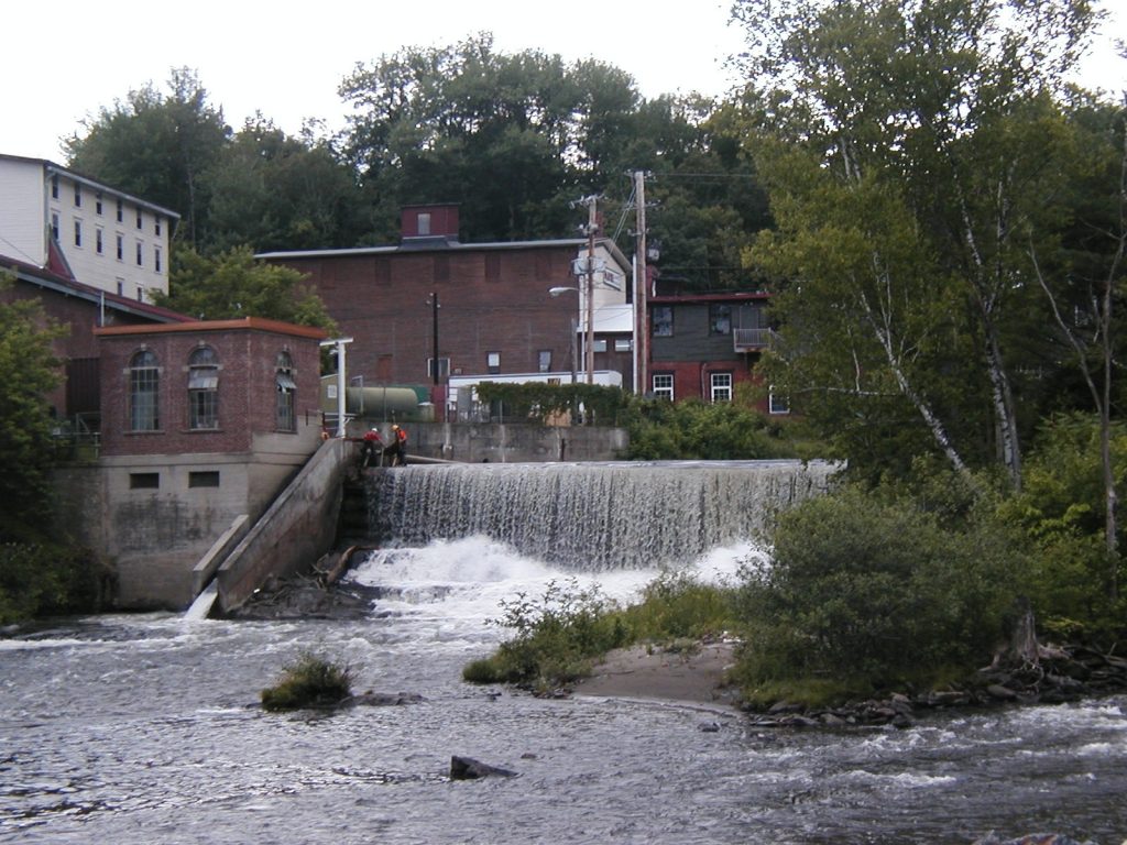
The Arnold Falls Project is located in northeastern Vermont in St. Johnsbury, Caledonia County, on the Passumpsic River. The dam and powerhouse were built in 1928 by the Twin State Gas & Electric Company following the 1927 flood which did extensive damage to the original station. Before 1928, the site contained facilities for water-powered manufacturing, including mills and pattern shops. Before these, a natural waterfall existed at the site. The falls bear the surname of Dr. Jonathan Arnold, an early settler and entrepreneur who constructed the first sawmill there in 1787 and a gristmill the following year. In 2009, the existing timber crib dams were abandoned in place and replaced with reinforced concrete gravity dams immediately downstream of the timber crib dams.
The project is the fourth dam on the Passumpsic River. Closest upstream is Pierce Mills (LIHI #92). Downstream are Gage (LIHI #94), Passumpsic Project (LIHI #95) and East Barnet (FERC No. 3051), the first dam on the river. The river is 22.7 miles long and a tributary to the Connecticut River, entering just downstream of Comerford Dam (part of the Fifteen Mile Falls Project, LIHI #39). The project is owned by Green Mountain Power (GMP), the first energy utility certified as a B-Corporation.
The project includes two concrete gravity dams, a powerhouse with a turbine and generator, bypassed reach, substation, and spillway.
The North Dam is 180-feet-long by 18-feet-high, with a dam crest elevation of 573.0 feet msl. It is topped with 20.4-inch hinged steel flashboards. The South Dam is 64-feet-long by 15-feet-high, with a crest elevation of 572.0 feet msl, topped with an inflatable flashboard system. The intake is 20-feet-wide with trashracks and a manually operated bulkhead gate. The dam creates a bypassed reach about 300-feet-long.
The powerhouse contains one vertical shaft turbine and a generator rated at 350 kW. The downstream fish passage facility is located in the sluiceway of the spillway adjacent to the intake.
The project operates in a run-of-river mode and impounds a 10-acre reservoir. The project provides minimum flows of 78 cfs through the North Spillway and 33 cfs through the South Spillway when not generating. The flow regime was established via consultation with Vermont Agency of Natural Resources (VANR) and the US Fish and Wildlife Service (USFWS) to ensure protection of aquatic habitat.
Waters within the project reach are designated as Class B and impaired for e. coli contamination due to the St. Johnsbury wastewater treatment facility. The project is not responsible for this contamination. Class B waters are managed to achieve aquatic wildlife habitat, aesthetic value, public water supply, and primary contact recreational uses.
While American eel populations were historically plentiful in the Connecticut River watershed, the presence of many dams on the river now prevent passage of the species. The downstream East Barnet Dam and dams on the Connecticut River block passage and USFWS has not requested upstream passage at the project. The project facilitates downstream passage through the sluiceway which provides a 25-cfs flow to a plunge pool. The passage is primarily utilized by resident trout species.
The project lands consist of roughly 10.6 acres. No lands of significant ecological value exist in the project property, as very little outside of the powerhouse and dam is under the project’s ownership. The surrounding land is primarily mixed industrial and commercial buildings.
Threatened or endangered species potentially present in the project vicinity include the Northern Long-eared Bat. Consultation with VANR has determined that project operations do not negatively affect the listed species. The primary concern for the Northern Long-eared Bat is the clearing of trees, of which the species rely on for habitat.
The project infrastructure, including the dams, intake structure, generating units, and powerhouse, is eligible for the National Register of Historic Places. The project operates under a cultural resources management plan, which ensures annual communications with the Vermont Division for Historic Preservation.
Recreational resources at the project include a canoe portage, portage trail, and a handicapped-accessible viewpoint and fishing deck just downstream of the project. The project owner voluntarily revised the Passumpsic River Canoeing and Recreation Guide and provides guided facility tours. Public access is provided free of charge.
Compliance Status
There are no facility-specific conditions in the current Certificate.
2026: No material changes or compliance issues were identified. The project remains in compliance based on the annual review.
2025: No material changes or compliance issues were identified. The project remains in compliance based on the annual review.
2024: No material changes or compliance issues were identified. The project remains in compliance based on the annual review.
2023: No material changes or compliance issues were identified. The project remains in compliance based on the annual review.
2022: No material changes or compliance issues were identified. The project remains in compliance based on the annual review.
2021: There were no reported changes or compliance issues. The project remains in compliance based on the annual review.
2020: There were no reported changes or compliance issues. The project remains in compliance based on the annual review.
2019: There were no reported changes or compliance issues. The project remains in compliance based on the annual review.
2018: The project reported installing new directional signage along the canoe portage route and a new picnic bench at the Le Clair site. FERC approved the improvements in 2017. The project remains in compliance based on the annual review.
2017: Annual reporting for the current Certificate has not yet taken effect.
Certification History
January 1, 2022: The LIHI Certificate term has been extended in accordance with Revision 2.05 of the LIHI 2nd Edition Certification Handbook issued January 1, 2022. Refer to the facility table above for the new term.
August 15, 2018: The decision to recertify the Arnold Falls Hydroelectric Project is final. No appeals were received during the appeal period which closed on August 11, 2018. The new term for the Arnold Falls Project is from February 6, 2017 through February 5, 2022.
July 12, 2018: The Low Impact Hydropower Institute (LIHI) preliminarily approved the Arnold Falls Hydroelectric Project for a new 5-year term of Low Impact Certification. This decision is preliminary pending the 30-day appeal window. Only those who commented in the initial application during the 60-day comment period are eligible to file an appeal. Such appeal needs to include an explanation as to how the projects do not meet the LIHI criteria. Appeal requests can be submitted by email to comments@lowimpacthydro.org with “Arnold Falls Hydroelectric Project” in the subject line, or by mail addressed to the Low Impact Hydropower Institute, 329 Massachusetts Ave, Suite 2, Lexington, MA 02420. All requests will be posted to the website and the applicant will have an opportunity to respond and any response will also be posted. Requests must be received by 5 pm Eastern time on August 11, 2018. The full application and reviewer’s report are available below. If no appeal requests are received and the decision becomes final, the new term for the Arnold Falls Project will be February 6, 2017 through February 5, 2022.
June 11, 2018: The Arnold Falls certification term has been extended again to September 30, 2018.
April 3, 2018: The Arnold Falls y certification term has been extended again to June 30, 2018.
November 28, 2017: The Arnold Falls certification term has been extended to March 31, 2018.
December 30, 2016: The Low Impact Hydropower Institute has received a complete application for a new term of Low Impact Certification for the Arnold Falls Hydroelectric project. The application materials can be found in the Files section below. LIHI is seeking public comment on this application. Specifically, we are interested in knowing whether you think the Arnold Falls project meets the LIHI Low Impact Certification Criteria, as revised in the 2nd Edition Handbook released in March 2016. Please review the program and criteria in LIHI’s revised Handbook and then review the Project’s 2016 application materials posted on the project page. Comments that are directly tied to specific LIHI criteria (flows, water quality, fish passage, etc.) will be most helpful, but all comments will be considered. Comments may be submitted to the Institute by e-mail at comments@lowimpacthydro.org with “Arnold Falls Project Comments” in the subject line, or by mail addressed to the Low Impact Hydropower Institute, PO Box 194, Harrington Park, New Jersey 07640. Comments must be received at the Institute on or before 5 pm Eastern time on March 4, 2017 to be considered. All comments will be posted to the web site and the applicant will have an opportunity to respond. Any response will also be posted.
December 16, 2016: The Arnold Falls Hydroelectric project has been granted an extension of the current certificate term. The new expiration date is May 6, 2017. See extension letter for explanation below.
September 9, 2012: The Arnold Falls project has been certified as low impact for a five year term, effective February 6, 2012 and expiring February 6, 2017.
April 6, 2012: Public comment period on application has closed.
February 6, 2012: The Central Vermont Public Service Corporation has submitted an application for the certification of the Arnold Falls project. Public comment period on application has opened.
Certification Files
2017 Recertification
2012 Certification
- Arnold Falls Certification Review Report
- Passumpsic River Projects – Certification Questionnaire
- Arnold Falls Recreation Plan
- Passumpsic River Projects Cultural Recreation Management Plan Documents
- Passumpsic River Projects Recreation Documents
- Passumpsic River Projects – Resource Agencies