LIHI Certificate #62 - Cutler Project, Utah
| Project Name | Cutler |
| LIHI Certificate No. | 62 |
| LIHI Certificate Term | December 31, 2014 – December 31, 2022, extended to December 31, 2026 |
| Owner | PacifiCorp Energy |
| State | Utah |
| Location | Located at river mile 65.9 on the Bear River |
| Installed Capacity | 30 MW |
| Average Annual Generation | 84,185 MWh |
| Facility Type | Daily peaking |
| FERC No. | P-2420 issued in 1994, expires 03/31/2024 |
The Cutler Project is located in northern Utah between the Bear River and Wellsville Mountain ranges, mostly in Cache County, and impounds waters from the Bear, Little Bear, Logan, and Spring Creek rivers. The project is part of the Bear River Basin which extends through northeastern Utah, southeastern Idaho, and southwestern Wyoming. The basin comprises approximately 7,500 square miles of mountain and valley lands (2,700 in Idaho, 3,300 in Utah, and 1,500 in Wyoming).
The Bear River headwaters and its mouth are only 90 miles apart. But the river takes its time spanning those points, flowing 500 miles over a tortuous path crossing state boundaries five times over the three states. It begins high in Utah’s Uinta Mountains, then spills north into Wyoming and Idaho, looping around the Wasatch Mountains. Near the town of Soda Springs, Idaho, (and the Bear River Project, LIHI #53) the river makes a hard left turn and then flows south, down the other side of the Wasatch and back into Utah, where it discharges into the Great Salt Lake. It is the largest tributary to the Great Salt Lake and the largest stream in the western hemisphere that does not empty into an ocean. The Bear River is unique in that it is entirely enclosed by mountains, thus forming a huge basin with no external drainage outlets.
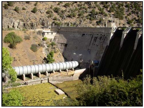
The project includes a 545-foot-long, 126-foot-high concrete gravity arch dam built in 1927. The dam has a spillway containing four 30-foot-wide by 14-foot-high radial gates. Irrigation canal intake gates are located at each abutment of the dam and are an integral part of the structure. Much of the reservoir has the characteristics of a shallow-water emergent marsh: the southern portion of the reservoir has a mean depth of 1.8 feet, while the slightly deeper section of the reservoir to the north has a mean depth of 3.6 feet; the northernmost portion of the reservoir located in Cutler Canyon is deeper and includes areas with depths up to 20 feet. The flowline intake is a concrete tower located in the reservoir approximately 60 feet upstream of the dam. It connects to an 18-foot-diameter steel-lined conduit that passes through the dam. A 1,160-foot-long, 18-foot-diameter steel penstock carries water to an 81-foot-high, 45-foot-diameter steel surge tank. Two 112-foot-long steel penstocks bifurcate from the surge tank and lead to the powerhouse. The powerhouse is a brick building containing appurtenant facilities and two vertical Francis generating units with a total installed capacity of 30 MW.
The project operates in a run-of-river mode and impounds an approximately 5,500-acre reservoir. The project operates seasonally in normal and low-water years, generally from late fall through early summer, based on the availability of flows after irrigation commitments are met (during high-water years there may be additional available flow). Typically, in order to meet the required irrigation contracts, the project suspends normal generation operations during summer flows (late-June or July through September or October), but the facility remains available to provide short-duration emergency generation (spinning reserve). During normal operation periods, the project is operated in a semi-automatic mode whereby the generators are started and synchronized to the system manually by the local operator. Resource agencies including the Utah Division of Wildlife Resources (UDWR) and USFWS provided recommendations to protect aquatic resources. These focused on maintaining and stabilizing the reservoir levels.
Waters within the project reach are listed as impaired for dissolved oxygen and phosphorus. The Utah Department of Environmental Quality (UDEQ) has concluded that the impairments are likely due to agricultural impacts and wastewater treatment plants upstream of the project. The project’s resource management plan monitoring reports document the implementation of measures including reducing non-point source pollution into the river and water quality monitoring, among others. This report is prepared in collaboration with USFWS, the US Forest Service, the National Parks Service, UDWR, the Utah Division of Water Resources, and the Utah Division of Parks and Recreation. These resource agencies have noted the success of mitigation efforts at the project, and UDEQ specifically provided their support of the project’s positive influence on water quality in the basin.
The Bear River is a tributary to the Great Salt Lake and has historically not supported any anadromous or catadromous fish species. Habitat improvement structures were recommended by resource agencies but the water quality in the watershed has led to a decline of the native fishery overall. Resident fish species include black bullhead, largemouth bass, black crappie, green sunfish, catfish, and bluegill; with the exception of Utah sucker, no native fish were documented during the most recent surveys of the reservoir, and no native fish species at all were documented in the Bear River below the reservoir.
The project lands consist of approximately 9,500 acres. The project’s resource management plan includes provisions to improve water quality, wildlife habitat, scenic resources, recreational access, and traditional agricultural uses. The project owner has established a protective buffer extending at least 200-feet from the reservoir’s high-water mark in most areas of the reservoir.
PLUS-Standard: Over 1,225-acres (99.6% of undeveloped land) of plants (predominately native grasses and shrubs) have been established around the reservoir. The buffer includes a vegetation enhancement program, protecting and creating designated wildlife habitats and reclaiming habitats with a mixture of native and non-native grasses and plants, establishing fencing to keep grazing animals from eroding the shoreline, and monitoring the zones and tenant’s compliance with lease terms annually. An agricultural lease program was also established to provide grazing land and farmland for local farmers. The program contains strict requirements to aid shoreline protection including restrictions on tilling and use of pesticides and herbicides.
Rare or sensitive species present in the project vicinity include the Bald eagle (unlisted in area), Long-billed Curlew, Short-eared Owl, and California Floater (an aquatic mollusk species); a single federally listed Threatened plant species is present on project lands: the Ute ladies’-tresses orchid. USFWS has confirmed that the project does not impact listed species.
Cultural resources in the project area include the dam and powerhouse which are listed on the National Register of Historic Places. The project operates under a cultural resources management plan which contains provisions for consultation with the State Historic Preservation Office in the event of new resource discovery as well as protection and mitigation of any project impacts on listed resources.
Recreational resources at the project includes eight day-use sites, two boat-in picnic sites, two hiking trails, a boat ramp, and three canoe trails. Project lands are used for both land-based (hiking, upland game hunting, birding, etc.) and water-based recreation (boating, water-skiing, fishing, waterfowl hunting, etc.) activities. Public access is provided free of charge.
Additional details regarding the Cutler Hydroelectric Project and its ongoing relicensing process can be found HERE.
Compliance Status
The Certificate includes the following facility-specific conditions:
Condition 1. The facility owner shall notify the Utah Division of Wildlife Resources, Northern Region Aquatic Manager, prior to any reservoir drawdowns that exceed normal Cutler operating conditions, and work with that agency to minimize the impact of any such drawdown to sensitive aquatic species.
Condition satisfied in 2019. Condition 2. If a viable population of bluehead sucker (Catostomus discobolus) is found in or below Cutler Reservoir in the future, a meeting between PacifiCorp and the UDWR will be initiated to discuss life history needs of this species. The facility owner shall notify LIHI within 30 days of any such finding and shall keep LIHI informed of the results and courses of action taken as a result of the discussions with UDWR.
2025: No material changes or compliance issues were identified. The project remains in compliance based on the annual review. For Condition 1, the project reported no activity. The project is still awaiting a new FERC license, which when received will trigger a mid-term LIHI review.
2024: No material changes or compliance issues were identified. The project remains in compliance based on the annual review. For Condition 1, the project reported no activity. FERC issued its relicensing EA on July 26, 2024.
2023: No material changes or compliance issues were identified. The project remains in compliance based on the annual review. For Condition 1, the project reported no activity. The project reported voluntarily implementing enhancements pre-license including improving habitat for monarch butterfly and other pollinators with new milkweed and forage plantings for pollinators, protecting and improving habitat for the Ute ladies’ tresses orchid, adopting the new provisions of the Historical Properties Management Plan for projects that may occur in the interim period, and some recommended recreation improvements.
2022: No material changes or compliance issues were identified. The project remains in compliance based on the annual review. For Condition 1, the project reported no activity. The project filed its final FERC relicensing application on 03/28/2022 and received a new state water quality certificate on October 13, 2022.
2021: There were no reported changes or compliance issues. The project remains in compliance based on the annual review. For Condition 1, the project reported no activity. The project filed its draft FERC relicensing application on 10/29/2021.
2020: There were no reported changes or compliance issues. The project remains in compliance based on the annual review. For Condition 1, the project reported no activity.
2019: There were no reported changes or compliance issues. The project remains in compliance based on the annual review. The project began FERC relicensing with filing of the PAD on 03/29/2019. For Condition 1, the project reported on consultation for, and completion of a planned impoundment drawdown, with agency approval. For Condition 2, the project reported on a state fishery survey which did not find any bluehead suckers, thus satisfying this condition.
2018: There were no reported changes or compliance issues. The project remains in compliance based on the annual review. For Condition 1, the project reported no activity. For Condition 2, the project reported no change in status.
2017: There were no reported changes or compliance issues. The project remains in compliance based on the annual review.
2016: There were no reported changes or compliance issues. The project remains in compliance based on the annual review.
2015: There were no reported changes or compliance issues. The project remains in compliance based on the annual review.
2014: Annual reporting for the current Certificate has not yet taken effect.
Certification History
June 28, 2022: In accordance with Section 6.1 of the LIHI Handbook, the LIHI Technical Committee recently voted to extend the current certificate term by one year to allow for the FERC relicensing process to complete.
August 12, 2015: LIHI Executive Director Michael J. Sale, using authority delegated from the LIHI Governing Board, has determined that the Cutler Hydroelectric Project (FERC No. 2420) continues to meet the LIHI Certification Criteria. The effective certification date for the Cutler Project is December 31, 2014 for an eight (8) year term, which will expire on December 31, 2022.
February 3, 2015: The Low Impact Hydropower Institute received a complete and timely application for a new term of Low Impact Certification for the Cutler Hydroelectric project on November 20, 2014. Please see the application files below.
October 22, 2010: The Cutler Hydroelectric Project has been certified as low impact for a five year term, effective December 31, 2009 and expiring December 31, 2014.
December 31, 2009: PacifiCorp Energy has submitted an application for the certification of the Cutler Hydroelectric Project. Public comment period will remain open for 60 days.
Certification Files
2014 Recertification
- Cutler Recertification Review Report 2015
- Cutler Recertification Questionnaire 2014
- Cutler Recertification Questionnaire Attachments
2010 Certification
- Cutler Certification Review Report
- Cutler Certification Questionnaire
- Cutler Certification Questionnaire Attachments