LIHI Certificate #53 - Bear River Project, Idaho
| Project Name | Bear River |
| LIHI Certificate No. | 53 |
| LIHI Certificate Term | August 5, 2025 – December 29, 2038 |
| Owner | PacifiCorp Energy |
| State | Idaho |
| Location | Located between river mile 143 and 183 on the Bear River in northeastern Utah, southeastern Idaho, and southwestern Wyoming. |
| Installed Capacity | Total: 77.45 MW Soda Development: 14.45 MW Grace Development: 33 MW Oneida Development: 30 MW |
| Average Annual Generation | Total: 173,548 MWh Soda Development: 21,128 MWh Grace Development: 105,969 MWh Oneida Development: 46,451 MWh |
| Facility Type | Modified run-of-river |
| FERC No. | P-20 issued in 2003, expires 11/30/2033 |
The Bear River Project is located on the Bear River in Caribou and Franklin Counties, Idaho. The Bear River Basin is located in northeastern Utah, southeastern Idaho, and southwestern Wyoming.
The Bear River headwaters and its mouth are only 90 miles apart. But the river takes its time spanning those points, flowing 500 miles over a tortuous path crossing state boundaries five times over the three states. It begins high in Utah’s Uinta Mountains, then spills north into Wyoming and Idaho, looping around the Wasatch Mountains. Near the town of Soda Springs, Idaho, the river makes a hard left turn and then flows south, down the other side of the Wasatch and back into Utah, where it discharges into the Great Salt Lake. It is the largest tributary to the Great Salt Lake and the largest stream in the western hemisphere that does not empty into an ocean. The Bear River is unique in that it is entirely enclosed by mountains, thus forming a huge basin with no external drainage outlets.
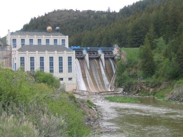
The Bear River project consists of three dams and powerhouses – Soda, Grace, and Oneida developments. The Soda development is located the farthest upstream on the Bear River, five miles west of the city of Soda Springs in Caribou County, Idaho. The Last Chance (also owned by PacifiCorp) development is located on the Last Chance Canal, a diversion from the Bear River that is located four miles downstream of the Soda powerhouse. The Grace development is the next facility downstream, and it is also located in Caribou County, Idaho. The Oneida Project is located in Franklin County, Idaho, approximately 6 miles south of Cleveland, Idaho. Other dams are located downstream, including the Cutler Project (LIHI #62) located in Utah.
The project includes three developments:
- Soda: The Soda development consists of a 103-foot-high by 433-foot-long concrete gravity dam with a 109-foot-long integral powerhouse section containing five headgates that supply water to the generating unit penstocks and to a 900 cfs-capacity low-level discharge (Johnson valve). The dam also has a 210-foot-long non-overflow gravity section and a 114-foot-long gated overflow spillway section containing three, 30-foot by 14-foot Tainter gates. A 55-foot-long by 19-foot-high earth fill dam also forms parts of the development. The Soda reservoir (commonly referred to as the Alexander reservoir) has a surface area of 1,100 acres. It extends approximately 4.5 miles upstream to just below the Big Spring Creek confluence with the Bear River. The powerhouse contains two vertical Francis units, each with an installed capacity of 7 MW.
- Grace: The original Grace dam and the existing power facilities were constructed shortly after 1910. A new dam was constructed in 1951 and the original rock-filled, timber-crib dam is now submerged in the forebay just upstream of the 1951 dam. Grace dam is a rock-filled, timber-crib structure with a concrete core at the base of the structure. The structure stands approximately 51 feet high with 8-foot-high flashboards. The crest length is 180.5 feet. The dam creates a 320 acre-ft impoundment. A 52-foot-wide intake structure containing eighteen 5-foot by 10-foot screen sections is housed within a concrete stucco building, adjacent to the earth embankment section of the dam. A 26,000-foot-long 11-foot-diameter flowline consisting of 15,000 feet of steel and 11,000 feet of wood stave pipeline conveys water from the intake structure to two surge tanks, one 10 feet in diameter and 38 feet high, located approximately 2.6 miles downstream of the diversion, and the other 30 feet in diameter and 132 feet high, located directly above the powerhouse. Three 90-inch-diameter steel penstocks equipped with two butterfly valves carry water from the surge tanks to the powerhouse. The powerhouse has three turbine generators rated at 11 MW each for a total plant capacity of 33 MW. The tailrace includes a short concrete-lined section that transitions to an unlined open channel section approximately 350 feet from its confluence with the Bear River.
- Oneida: The Oneida development includes a 111-foot-high by 381-foot-long concrete gravity dam that includes a 118-foot-long uncontrolled auxiliary spillway, a 66-foot-long non-overflow gravity section, a 99-foot-long gated spillway containing five Tainter gates, and an 86-foot-long gravity section with ice sluices. There is also a 40-foot-high, 1,100-foot-long embankment dam. The Oneida reservoir has a surface area of 480 acres. A 50-foot-wide by 50-foot-high intake structure, containing six openings fitted with trashracks, transitions to two, 16-foot-diameter circular outlets. A 16-foot-diameter, 2,240-foot-long steel flowline conveys water from the intake structure to a 40-foot-diameter, 142-foot-high surge tank. Three 12-foot-diameter, 120-foot-long steel penstocks extend from the surge tank to the powerhouse which contains three vertical Francis units, each with an installed capacity of 10 MW. The development has a 64-foot-wide by 118-feet-long rectangular channel tailrace.
The project operates in coordinated modified run-of-river mode to meet irrigation demands in addition to generating power. River flows are generally higher than the natural conditions during the irrigation season (April through October) due to irrigation releases from Bear Lake. The Soda, Grace, and Oneida developments are usually operated in a modified run-of-river mode during this season; water stored in Soda and Oneida reservoirs may be used to satisfy short-term irrigation demand. Each development provides minimum flows:
- Below the Soda dam – year-round minimum flow of 150 cfs, or inflow into the Alexander reservoir, whichever is less;
- Grace bypass reach – year-round minimum bypass flow of 48 cfs or inflow, whichever is less, in addition to 2 cfs leakage from the dam;
- Oneida reach below the powerhouse: year-round minimum flow of 250 cfs or inflow, whichever is less, in addition to 1 cfs leakage from the dam.
Waters within the project reach are used for irrigation and power generation. Water quality monitoring has occurred several times at the developments to determine the project’s impacts on temperature, dissolved oxygen, nutrients, and turbidity. The primary concern with water quality at the project is excess sediment which was mitigated via the elimination of peaking events and the establishment of a maximum ramping rate. The Idaho Department of Environmental Quality has noted that the project is not contributing to exceedances of water quality standards.
No migratory fish species have been noted in the project area. Additionally, there are limited numbers of native fish in Bear River, thus fish entrainment has not been a significant issue at the project. The Bear River has been targeted for restoration, enhancement, and protection activities for riverine fisheries with a particular focus on the Bonneville cutthroat trout (BCT) in areas outside of the Project. A BCT Restoration program was implemented to provide off-site mitigation and restoration of habitat for BCT and other aquatic species.
The project lands consist of 2,189 acres of land and 1,671 acres of water. The project operates under a Habitat Restoration Program, a Land Management Plan, contributes to a Land and Water Conservation Fund, funds a broodstock and conservation hatchery program with Idaho Department of Fish and Game, and contributes to creel and macroinvertebrate studies. Project contributions to these programs and funds totaled nearly $8 million to date with additional annual funding of $467,000 (in 2002 dollars) to support watershed protection, as approved under the relicensing Settlement Agreement. These programs have established conservation lands, helped to enhance Bonneville cutthroat trout populations, assessed recreation impacts on the river, and more.
PLUS-Standard: The project owner provides significant annual funding to support habitat conservation measures in areas impacted by the project. Dedicated buffer zones have also been established around the project areas. Collectively, approximately 1,637 acres have been designated conservation lands.
Threatened or endangered species potentially present in the project vicinity include the bald eagle, Canada lynx, yellow-billed cuckoo, and Ute’s ladies’ tresses. Consultation with the US Fish and Wildlife Service concluded that project operations are not likely to adversely impact any of the listed species.
The three developments each support several historic or archaeological sites. In total, the project has over 60 sites of historic or archaeological significance, thus a Historic Properties Management Plan was developed to protect and manage these properties. Annual reports of activities concerning these sites are filed with the State Historic Preservation Office, US Bureau of Land Management, and the Shoshone-Bannock Tribes. Project operational staff receive cultural resources training to ensure proper stewardship of the properties. Interpretative signage regarding historical resources and traditional cultural properties are installed at sites throughout the project reaches.
Recreational resources at the project include two campgrounds managed by the Bureau of Land Management; two parks/marinas managed by Caribou County; several day-use areas; put-in/take-out access points in the Grace bypass and Oneida downstream reach, and whitewater releases conducted in consultation with American Whitewater. Additionally, the project provides funding to the Bureau of Land Management and Caribou and Franklin counties for management of the recreational sites in the project vicinity. Public access is provided free of charge to the reservoirs and downstream reaches of the projects.
Compliance Status
There are no facility-specific conditions in the current Certificate.
2025: No compliance issues were identified. The project remains in compliance based on the annual review. LIHI conducted a mid-term review related to the Grace development’s license amendment. See files below.
2024: No compliance issues were identified. The project remains in compliance based on the annual review. The project reported that FERC issued a license amendment on August 27, 2024 approving reduction of the minimum flow in the Grace bypass reach. That change triggers a targeted mid-term LIHI review subject to public comment which LIHI will announce when information on the change has been submitted.
2023: No material changes or compliance issues were identified. The project remains in compliance based on the annual review. The project filed an application with FERC to amend the project license to reduce minimum flows in the Grace bypass reach to 48 cfs plus 2 cfs leakage. This proposal relates to decommissioning of the Paris Project (FERC No. 703) to improve aquatic habitat in Paris Creek.
Certification History
August 5, 2025: The Low Impact Hydropower Institute has issued a final decision on the mid-term recertification of the Bear River Hydroelectric Project. No appeals were received during the appeal period which closed on July 23, 2025. The new Certification term is August 5, 2025 to December 29, 2038.
June 23, 2025: The Low Impact Hydropower Institute (LIHI) has preliminarily approved the Bear River Project for a new 13-year term of Low Impact Certification, as a result of a mid-term certification review. The reviewer’s report is available below. This decision is preliminary pending the 30-day appeal window. Only those who commented on the draft review report during the 60-day comment period are eligible to file an appeal. Such appeal needs to include an explanation as to how the Project does not meet the LIHI criteria. Appeal requests can be submitted by email to comments@lowimpacthydro.org with “Bear River Project” in the subject line, or by mail addressed to the Low Impact Hydropower Institute, 68 Harrison Ave Ste 605, PMB 113938 Boston, Massachusetts 02111-1929. All requests will be posted to the website. The applicant will have an opportunity to respond and any response will also be posted. Requests must be received by 5 pm Eastern time on July 23, 2025. If no appeal requests are received and the decision becomes final, the new Certification term for the Project will be December 30, 2025 through December 29, 2038.
March 24, 2025: The Bear River Project received a FERC license amendment on August 27, 2024, that changed operations of the Grace Development. In accordance with Section 5.3.4 of the LIHI Handbook, issuance of a FERC license amendment that affects the LIHI criteria constitutes a “material change” and triggers a mid-term LIHI Certification review. A new Certificate term can be granted if the project continues to satisfy the LIHI criteria, even if the current certification term has not yet expired. The applicant, PacifiCorp, has submitted a summary of the operational changes related to the FERC license amendment, found below in the Certification Files section. LIHI is seeking comment on this change. Comments that are directly tied to specific LIHI criteria (flows, water quality, fish passage, etc.) will be most helpful, but all comments will be considered. Comments may be submitted to LIHI by e-mail at comments@lowimpacthydro.org with “Bear River Project Comments” in the subject line, or by mail addressed to the Low Impact Hydropower Institute, 68 Harrison Ave Ste 605 PMB 113938, Boston, Massachusetts 02111-1929. Comments must be received at the Institute on or before 5 pm Eastern time on May 23, 2025 to be considered. All comments will be posted to the web site and the applicant will have an opportunity to respond. Any response will also be posted.
October 5 2023: The Low Impact Hydropower Institute has issued a final decision on the recertification of the Bear River Hydroelectric Project. The certification term is December 31, 2022 through December 30, 2035.
August 24, 2023: The Low Impact Hydropower Institute has preliminarily approved Low Impact recertification for the Bear River Hydroelectric Project. The full application and reviewer’s report are available below. This decision is preliminary pending the 30-day appeal window. Only those who commented on the initial application during the 60-day comment period are eligible to file an appeal. Such appeal needs to include an explanation as to how the Project does not meet the LIHI criteria. Appeal requests can be submitted by email to comments@lowimpacthydro.org with “Bear River Project” in the subject line, or by mail addressed to the Low Impact Hydropower Institute, 1167 Massachusetts Ave, Arlington, MA 02476. All requests will be posted to the website. The applicant will have an opportunity to respond and any response will also be posted. Requests must be received by 5 pm Eastern time on September 23, 2023. If no appeal requests are received the certification terms will be December 31, 2022 through December 30, 2035.
May 1, 2023: The Low Impact Hydropower Institute (LIHI) has received a complete recertification application from PacifiCorp for the Bear River Project. LIHI is seeking comment on this application. Comments that are directly tied to specific LIHI criteria (flows, water quality, fish passage, etc.) will be most helpful, but all comments will be considered. Comments may be submitted to LIHI by e-mail at comments@lowimpacthydro.org with “Bear River Project Comments” in the subject line, or by mail addressed to the Low Impact Hydropower Institute, 1167 Massachusetts Avenue, Arlington, MA 02476. Comments must be received at the Institute on or before 5 pm Eastern time on June 30, 2023 to be considered. All comments will be posted to the web site and the applicant will have an opportunity to respond. Any response will also be posted. The complete application can be found below.
July 24, 2015: LIHI Executive Director Michael J. Sale, using authority delegated from the LIHI Governing Board, has determined that the Bear River Hydroelectric Project (FERC No. 20) continues to meet the LIHI Certification Criteria. The effective certification date for the Bear River Project is December 31, 2014 for an eight (8) year term, which will expire on December 31, 2022. The additional three years are earned for enhancements to the watershed.
February 3, 2015: The Low Impact Hydropower Institute received a complete and timely application for a new term of Low Impact Certification for the Bear River Hydroelectric project on November 20, 2014. Please see the application files below.
May 19, 2010: The Bear River Hydroelectric Project has been certified as low impact for a five year term, effective December 31, 2009 and expiring December 31, 2014.
March 3, 2010: The public comment period has been closed.
December 31, 2009: PacifiCorp Energy has submitted an application for certification of the Bear River Hydroelectric Project. A public comment period will remain open for 60 days.
Certification Files
2025 Mid-Term Review
- Bear River Mid-Term Review Report
- Bear River Mid-Term Review Submittal
- Bear River FERC Amendment 2024
- Bear River FERC Environmental Assessment 2024
- Bear River License Amendment Application and Paris Creek Agreement
2023 Recertification
2015 Recertification
- Bear River Recertification Review Report
- Bear River Recertification Questionnaire 2014
- Bear River Recertification Questionnaire Attachments 2014
- Bear River Recertification Statement 2014
2010 Certification
- Bear River Certification Review Report 2010
- Bear River Certification Questionnaire
- Bear River Certification Application Attachments
- Application Attachment – PacifiCorp Supporting Information
- PacifiCorp Response to Certification Condition