LIHI Certificate #48 - Androscoggin Project, Maine
| Project Name | Androscoggin |
| LIHI Certificate No. | 48 |
| LIHI Certificate Term | September 25, 2019 – September 24, 2029 |
| Owner | Andro Hydro LLC, a subsidiary of Eagle Creek Renewable Energy, LLC |
| State | Maine |
| Location | Located between river miles 58 and 53.2 on the Androscoggin River in Maine. |
| Installed Capacity | Total: 29.4 MW Riley: 7.1 MW Jay: 3.1 MW Otis: 10.4 MW Livermore: 8.8 MW |
| Average Annual Generation | Total: 120,983 MWh Riley: 23,571 MWh Jay: 14,717 MWh Otis: 48,820 MWh Livermore: 33,875 MWH |
| Facility Type | Run-of-river |
| FERC No. | P-2375 (Riley, Jay, Livermore) issued in 1998, expires 09/15/2048
P-8277 (Otis) issued in 1998, expires 09/15/2048 |
The Androscoggin Project is located on the Androscoggin River near the towns of Canton, Jay, and Livermore, Maine. The Androscoggin River drains a watershed of 3,550 square miles and is head-watered in Umbagog Lake in Coos County, New Hampshire. The river flows south for 164 miles and joins the Kennebec River before entering into the Gulf of Maine. Twenty-five major dams have been constructed on the Androscoggin River: five downstream of the Project and 16 upstream of the Project. Five of the upstream dams form large storage reservoirs located primarily in northern Maine. These storage reservoirs are operated to provide a reliable uniform target flow during the summer at Berlin, New Hampshire. These releases, augmented by tributary inflow, provide water for the Androscoggin Project. The nearest dams are Rumford Falls (LIHI #38) upstream, and Gulf Island including Deer Rips/A-3, (LIHI #163) downstream.
The project consists of four separate facilities: Riley, Jay, Otis, and Livermore. Otis is operated under a separate FERC license (No. 8277) from the other developments which are licensed as FERC No. 2375.
The project includes four developments:
- Riley is the most upstream of the four developments, located at river mile 58.0. Riley dam is a 19.2-foot-high by 757-foot-long, L-shaped, rock-filled timber crib structure. The dam is topped with 48-inch-high flashboards. A triangular forebay discharges to the six identical turbines in the powerhouse. The turbines are horizontal shaft units, installed in 1982, each rated for 926 cfs hydraulic capacity and a total installed capacity of 7.1 MW. The Riley forebay is the source of process water supply to a pulp and paper mill.
- Jay is located at river mile 56.5. Jay dam is 893 feet in length and is comprised of three non-contiguous sections separated by 2 island areas. The two outer sections of the Jay dam are topped with 32-inch flashboards. Jay has a 320-foot-long forebay leading to the powerhouse. The six turbine-generators, installed in the early 1900’s, are rated for a total flow of 3,300 cfs and have a total installed capacity of 3.1 MW.
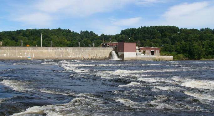
- Otis is located at river mile 54.0. The dam is composed of two contiguous spillway sections totaling 577 feet in length and topped with 24-inch flashboards. A 95-foot-long forebay leads the powerhouse which contains two turbines, each rated for 3,000 cfs at 26 feet of head, with a total installed capacity of 10.4 MW. While the Otis dam is over 100 years old, the Otis powerhouse and turbines were constructed in 1984.
- Livermore is located at river mile 53.2 and is the farthest downstream development. The dam is made of two contiguous spillway sections, totaling 599 feet in length and topped with 28-inch flashboards. A 185-foot-wide by 594-foot-long forebay leads to two separate powerhouses: (1) the (original) powerhouse containing eight identical horizontal turbines (early 1900’s vintage) with total hydraulic capacity of 3,456 cfs and eight generators with total installed capacity of 7.8 MW; and (2) a powerhouse constructed in 2004 containing one vertical turbine, discharging into the rocky area at the side of the forebay, with a hydraulic capacity of 450 cfs and total installed capacity of 1.0 MW.
The project operates in a run-of-river mode with varying minimum flow provisions. The Riley, Jay, and Livermore developments maintain:
- Minimum flows of at least 5 cfs below the Jay Development from June 15 through September 15 to improve water quality during the low flow season and enhance fish spawning and habitat in the southern bypassed reach of the Jay Development.
- Minimum flows of 150 cfs during the months of May, June, and October and 100 cfs during the remainder of the year from Livermore Dam into the upper portion of the Livermore Bypassed Reach. These flows are needed to maintain dissolved oxygen levels at or above the minimum state standard and to maintain the brown trout and bass fishery.
- Minimum flows of 550 cfs (consisting of the upper bypass flow, plus minimum flow turbine releases) from the Livermore Dam and Powerhouse into the lower bypassed reach to improve water quality and fishery habitat.
This flow regime was developed by the Maine Department of Environmental Protection (MDEP).
The Androscoggin River has historically been contaminated by past industrial actions resulting in poor water quality conditions. MDEP has prohibited the consumption of fish from the river due to the high levels of contamination. MDEP has concluded that the project developments do not adversely impact the river’s water quality.
A natural falls, Lewiston Falls, is located 20 miles downstream of the project and has precluded access for anadromous and catadromous fish species. MDEP has confirmed that Lewiston Falls has historically blocked migratory fish access to the project reach. Resident river species include smallmouth bass, rainbow trout, brown trout, bass, perch, and sunfish.
The project lands consist of roughly 29 acres. The area in the project vicinity is mostly composed of forested land, rural and residential housing, small towns, and some industrial and commercial areas. The Androscoggin Verso Paper Mill is located in Jay, Maine between the Riley and Jay facilities. The FERC boundary encompasses only the immediate shoreline and lands around project facilities. Beyond the FERC boundary there are forested areas on both sides for the river. No lands of significant ecological value exist in the project area.
Threatened or endangered species potentially present in the project vicinity include the Northern long-eared bat, bald eagle, and spotted wintergreen. The most common disturbance to the species and their habitat is tree-clearing activities and corridor maintenance. No such activities are planned at the project and project operations are not expected to impact the bat species. Similarly, no maintenance activities or operations are expected to impact bald eagles that may occur in the area. Consultation with the Maine Department of Agriculture, Conservation, and Forestry concluded that plant species would not be impact by project operations.
Studies conducted prior to the issuance of the project’s Federal Energy Regulatory Commission (FERC) license revealed that the area around the project developments is culturally rich. Over 60 aboriginal sites and six prehistoric sites were identified in the study. The study found that humans entered the Androscoggin River basin headwaters between 9000 and 7000 BC. Canton Point, located on the Riley impoundment, was identified as the center of native activities for the entire Androscoggin River. A Programmatic Agreement was entered into by the project owner, Advisory Council on Historic Preservation, FERC, and the Maine State Historic Preservation Office to ensure the proper stewardship of the historic properties.
Recreational resources at the project include several boat launches, carry-in boat access, picnic areas, hiking trails, fishing access, and several more informal access points. The resources at the Riley development receive the most use while the facilities at the Jay development are not utilized as often. Public access is provided free of charge.
Compliance Status
There are no facility-specific conditions in the current Certificate.
2025: No material changes or compliance issues were identified. The project remains in compliance based on the annual review.
2024: No material changes or compliance issues were identified. The project remains in compliance based on the annual review.
2023: No material changes or compliance issues were identified. The project remains in compliance based on the annual review.
2022: No material changes or compliance issues were identified. The project remains in compliance based on the annual review. The project received a license amendment to bury part of the Livermore transmission line within the existing right-of-way. An environmental analysis was completed as part of the amendment application and no significant adverse impacts were identified. Agencies concurred.
2021: There were no reported changes or compliance issues. The project remains in compliance based on the annual review.
2020: There were no reported changes or compliance issues. The project remains in compliance based on the annual review.
Certification History
January 1, 2022: The LIHI Certificate term has been extended in accordance with Revision 2.05 of the LIHI 2nd Edition Certification Handbook issued January 1, 2022. Refer to the facility table above for the new term.
February 10, 2020: The decision to recertify the Androscoggin Project became final after the close of the appeals period on February 8, 2020 with no appeals filed. The Certification term is from September 25, 2019 – September 24, 2024.
January 9, 2020: The Low Impact Hydropower Institute has preliminarily approved Low Impact Recertification for the Androscoggin Hydroelectric Project. This decision is preliminary pending the 30-day appeal window. Only those who commented on the initial application during the 60-day comment period are eligible to file an appeal. Such appeal needs to include an explanation as to how the Project does not meet the LIHI criteria. Appeal requests can be submitted by email to comments@lowimpacthydro.org with “Androscoggin Project” in the subject line, or by mail addressed to the Low Impact Hydropower Institute, 329 Massachusetts Ave, Suite 6, Lexington, MA 02420. All requests will be posted to the website. The applicant will have an opportunity to respond and any response will also be posted. Requests must be received by 5 pm Eastern time on February 8, 2020. The full application and reviewers report are available below. If no appeal requests are received and the decision becomes final, the Certification term for the Project will be from September 25, 2019 to September 24, 2024.
October 3, 2019: The Low Impact Hydropower Institute has received a complete application for Low Impact Recertification of the Androscoggin Hydroelectric Project. LIHI is seeking public comment on this application. Specifically, we are interested in knowing whether you think the Project meets the LIHI Low Impact Certification Criteria, as revised in the 2nd Edition Handbook. Please review the program and criteria in LIHI’s revised Handbook and then review the Project’s application materials below. Comments that are directly tied to specific LIHI criteria (flows, water quality, fish passage, etc.) will be most helpful, but all comments will be considered. Comments may be submitted to the Institute by e-mail at comments@lowimpacthydro.org with “Androscoggin Project Comments” in the subject line, or by mail addressed to the Low Impact Hydropower Institute, 329 Massachusetts Avenue, Suite 6, Lexington, MA 02420. Comments must be received on or before 5 pm Eastern time on December 3, 2019 to be considered. All comments will be posted to the web site and the applicant will have an opportunity to respond. Any response will also be posted.
June 24, 2015: Executive Director Michael J. Sale, using authority delegated from the LIHI Governing Board, has determined that the Androscoggin Hydroelectric Project (FERC Nos. P- 2375, and P-8277) continues to satisfy the LIHI Certification Criteria. The effective certification date for the Androscoggin Project is September 25, 2014 for a five (5) year term, which will expire on September 25, 2019. The Androscoggin Certification includes one project specific condition:
- Satisfied 2019. Condition 1: The facility owner shall consult with the Maine Department of Environmental Protection (MDEP) on water quality issues below the dams, provide the most recently collected monitoring data for dissolved oxygen concentrations (DO) to MDEP, and determine whether additional monitoring data are needed below their Androscoggin dams. The facility owner shall provide documentation to LIHI by December 31, 2015, concerning MDEP’s conclusion on DO monitoring and conduct any new DO sampling as required by MDEP.
July 21, 2014: The Low Impact Hydropower Institute has received an application for a second term of certification of the Androscoggin Hydroelectric Project. The application materials are posted in the “Files” section below.
April 8, 2010: The Androscoggin Hydroelectric Project has been certified as low impact for a five year term, effective September 25, 2009 and expiring September 25, 2014.
September 25, 2009: Verso Androscoggin LLC has submitted an application for certification of the Androscoggin Project. Comments regarding the application may be submitted until November 25, 2009.
Certification Files
2019 Recertification
- Androscoggin Recertification Review Report 2019
- Androscoggin Recertification Application 2019
- Maine Department of Environmental Protection Comment Letter – Androscoggin Recertification
2014 Recertification
- Androscoggin Recertification Review Report 2015
- Androscoggin Recertification Application Questionnaire
- Application Attachment 1-2
- Application Attachment 3
- Application Attachment 4
2009 Certification
- Androscoggin Certification Review Report
- Androscoggin Certification Application
- Application Appendix A
- Application Appendix D