LIHI Certificate #20 - Salmon River Project, New York

| Project Name | Salmon River |
| LIHI Certificate No. | 20 |
| LIHI Certificate Term | November 14, 2021 – November 13, 2034 |
| Owner | Erie Boulevard Hydropower, LP, a subsidiary of Brookfield Renewable Energy Group |
| State | New York |
| Location | Located between river mile 13.8 and 18 on Salmon River in the towns of Redfield and Orwell, Oswego, New York. |
| Installed Capacity | Total: 36.25 MW Bennett’s Bridge: 28.75 MW Lighthouse Hill: 7.5 MW |
| Average Annual Generation | 116,354 MWh |
| Facility Type | Bennett’s Bridge: Seasonal store and release that operates in a peaking mode. Lighthouse Hill: Store and release that operates in re-regulating mode. |
| FERC No. | P-11408 issued in 1996, expires 01/31/2036 |
The Salmon River Project consists of two developments along the Salmon River in the towns of Redfield, Orwell, and Oswego, New York. The Salmon River has a 285-square-mile drainage basin located in the north-central region of the state and discharges to Lake Ontario at Port Ontario in Oswego County. The project’s operational plan was developed via the Salmon River Project Settlement Offer (SRPSO) in consultation with New York State Department of Environmental Conservation (NYSDEC), New York Rivers United, the Adirondack Mountain Club, and Trout Unlimited. The SRPSO was designed to provide for the continued operation of the project with long-term environmental protection measures and the balance of power and non-power values in the Salmon River Basin.
The project includes two developments:
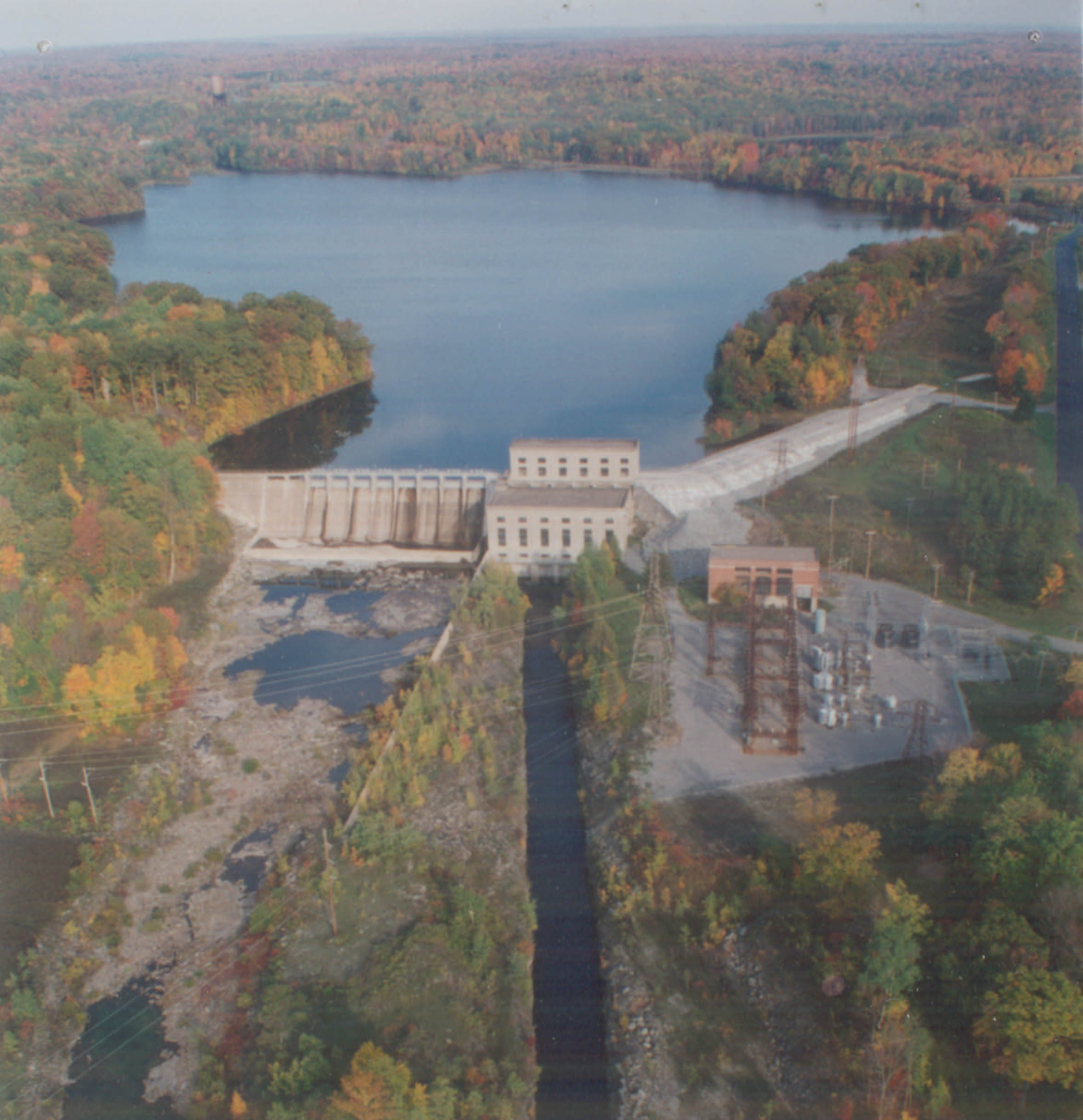
- Bennett’s Bridge Development: The dam is a 607-foot-long and 45-foot-high concrete gravity dam with a reinforced concrete intake structure, 92 feet long by 39.5 feet wide by 53 feet high. The dam is comprised of a 107-foot-long non-overflow section, a 244-foot-long ungated spillway section equipped with 2-foot-high flashboards, and a 256-foot-long gated spillway section with eleven 11.5-foot-high by 20-foot-wide Tainter gates. The dam impounds a reservoir with a maximum surface area of 3,550 acres which creates a 3.5-mile-long bypass reach. Three earth dikes 100 feet, 1,330 feet, and 695 feet long are located along the south shore of the reservoir. The 10,000-foot-long conduit system consists of: a concrete tunnel section 650 feet long and 12 feet in diameter; a reinforced plastic pipeline section 7,790 feet long and 12 feet in diameter; a steel pipeline section 1,200 feet long and 11.5 feet in diameter; a surge tank 105 feet high; a steel distributor 200 feet long and 12 feet in diameter; and four steel penstocks, each 330 feet long and 8 feet in diameter, with associated shut-off and air valves. The powerhouse is made of concrete, brick, and steel, and contains four horizontal Francis turbine-generator units with a combined capacity of 28.75 MW.
- Lighthouse Hill Development: The dam is a 382-foot-long concrete gravity dam consisting of a 155-foot-long and 59-foot-high non-overflow section, a 43-foot-long and 53-foot-high ungated spillway section controlled by 1-foot-high flashboards, and a 184-foot-long and 46-foot-high spillway section, gated with eight 20-foot-wide by 7-foot high Tainter gates equipped with 1-foot-high flashboards. The dam impounds a reservoir with a maximum surface area of 170 acres which creates a 0.57-mile-long bypass reach. The earthen dike is 324 feet long and 40 feet high. The development has three 17-foot-wide by 8-foot-high by 62-foot-long concrete penstocks and a 15-foot-long sluice gate section leading to the powerhouse. The powerhouse is made of concrete, brick, and steel with an intake structure, containing two vertical Francis turbine-generator units and an environmental flow turbine-generator unit. Combined capacity of all units is 7.5 MW. The environmental flow generating unit is operated to continuously release year-round base flows. The tailrace is 40 feet wide and 2,800 feet long.
The project operates as a seasonal store-and-release facility in a peaking mode at the Bennett’s Bridge development and as a store-and-release facility in a re-regulating mode at the Lighthouse Hill development. Flows are dictated by the SRPSO and a Flow Management Advisory Team is responsible for evaluating changing conditions that may affect river flows and thus change project flow operations. The team consists of NYSDEC, US Fish and Wildlife Service (USFWS), the National Park Service, NYS Office of Parks, Recreation, and Historic Preservation, American Whitewater, New York Rivers United, Trout Unlimited, Adirondack Mountain Club, Oswego County River Guides, Oswego County Federation of Sportsmen’s Clubs, Oswego County Legislators, Village of Pulaski Mayor, Albion County Legislator, Supervisor Town of Redfield, Pulaski/Eastern Shore Chamber of Commerce, Salmon River Fishery Committee, and the project owner.
The Bennett’s Bridge development provides a continuous minimum flow of 20 cfs from July 1 through September 30 and 7 cfs the rest of the year into the bypass reach, with impoundment ramping restrictions that vary based on inflow. The Lighthouse Hill development is operated according to a rule curve to protect and enhance aquatic resources, water quality, fisheries, aesthetic resources, and recreation resources. The development provides a 22-cfs flow directly to the Salmon River Fish Hatchery.
Waters within the project reach are designated as a cold-water fishery that supports trout. These waters are best suited for fishing and all other uses except as a source of water supply for drinking, culinary or food processing purposes, and primary contact recreation. The river reach is also listed as impaired for PCBs and Mirex, contaminated sediments. NYSDEC has determined that the project is not contributing to, or causing, this impairment.
Fish passage in the project vicinity has historically been blocked by the natural 110-foot Salmon River Falls located about 1 mile downstream of Bennet’s Bridge. Resource agencies have not prescribed any passage facilities at the project. Trashracks are installed at the Lighthouse Hill and Bennett’s Bridge developments with 1-inch spacing and 1.5-inch spaced overlays respectively.
The project lands consist mainly of state forest land, owned and managed by the state of New York. The project impoundments have dedicated buffer zones for conservation purposes.
PLUS-Standard: Through voluntary efforts, the project owner collaborated with the State to develop project land-use practices that are consistent with the adjoining state properties. A Land-Use Management Plan (LUMP) was developed with NYSDEC and provides management provisions for the shorelines and protects undeveloped properties in the area. The project owner also established and finances the Salmon River Enhancement Fund which supports efforts made under the LUMP for the Salmon River.
Threatened or endangered species potentially present in the project vicinity include the bald eagle, pied-billed grebe, northern long-eared bat, and Indiana bat. The bald eagle is an occasional transient species in the area but is not impacted by project operations. Any activities with the potential to impact the listed species, such as logging, must first have approval and consultation from USFWS.
Historic resources at the project include the Bennett’s Bridge powerhouse, dam, and surge tank. A historic properties management plan has been implemented at the project and includes provisions requiring the submission of annual reports on activities conducted at the project to the State Historic Preservation Office.
Recreational resources at the project include picnic areas, fishing access, boat ramps, a camping area, interpretive signage, and hiking trails. Additionally, the project owner provides releases for whitewater boating activities at least five weekends annually. Whitewater flows are provided as follows: one weekend in June – 400 cfs; two weekends in July – 750 cfs; the first full weekend in August – 750 cfs; and the first weekend in September – 750 cfs. Flow schedules are available at https://safewaters.com/facility/lighthouse-hill. Public access is provided free of charge.
Compliance Status
There are no facility-specific conditions in the current Certificate.
2025: No material changes or compliance issues were identified. The project remains in compliance based on the annual review.
2024: No material changes or compliance issues were identified. The project remains in compliance based on the annual review.
2023: No material changes or compliance issues were identified. The project remains in compliance based on the annual review.
2022: No material changes or compliance issues were identified. The project remains in compliance based on the annual review.
2021: Annual reporting for the current certificate has not yet taken effect.
Certification History
March 9, 2022: The Low Impact Hydropower Institute has issued a final decision on the recertification of the Salmon River Project. The 30-day appeal window closed on February 19, 2022 and no appeals were filed. Therefore, the decision to recertify the project is now final. The new term is November 14, 2021 through November 13, 2034, in accordance with the term extension that became effective January 1, 2022 in Revision 2.05 of the LIHI 2nd Edition Certification Handbook.
January 20, 2022: The Low Impact Hydropower Institute (LIHI) has preliminarily approved the Salmon River Project for a new 13-year term of Low Impact Certification. This decision is preliminary pending the 30-day appeal window. Only those who commented on the initial application during the 60-day comment period are eligible to file an appeal. Such appeal needs to include an explanation as to how the Project does not meet the LIHI criteria. Appeal requests can be submitted by email to comments@lowimpacthydro.org with “Salmon River Project” in the subject line, or by mail addressed to the Low Impact Hydropower Institute, 1167 Massachusetts Ave, Office 407, Arlington, MA 02476. All requests will be posted to the website. The applicant will have an opportunity to respond and any response will also be posted. Requests must be received by 5 pm Eastern time on February 19, 2022. The full application and reviewer’s report are available below. If no appeal requests are received and the decision becomes final, the Certification term for the Project will be November 14, 2021 through November 13, 2034.
October 27, 2021: The Low Impact Hydropower Institute (LIHI) has received a complete recertification application from Erie Boulevard Hydropower, LP for the Salmon River Project. LIHI is seeking comment on this application. Comments that are directly tied to specific LIHI criteria (flows, water quality, fish passage, etc.) will be most helpful, but all comments will be considered. Comments may be submitted to LIHI by e-mail at comments@lowimpacthydro.org with “Salmon River Project Comments” in the subject line, or by mail addressed to the Low Impact Hydropower Institute, 1167 Massachusetts Avenue, Office 407, Arlington, MA 02476. Comments must be received at the Institute on or before 5 pm Eastern time on December 26, 2021 to be considered. All comments will be posted to the web site and the applicant will have an opportunity to respond. Any response will also be posted. The complete application can be found below.
December 8, 2014: The Salmon River Hydroelectric Project (FERC No. 11408), LIHI Certificate No. 20 has been determined by the Executive Director, Michael J. Sale to satisfy the requirements of the Low Impact Hydropower Institute (LIHI) Certification Program. The decision to certify the Salmon River Hydroelectric Project is for an 8-year term, effective November 14, 2013 and expiring November 14, 2021.
November 18, 2013: Erie Boulevard Hydropower, L.P. has submitted an application for recertification of the Salmon River Project. Due to an administrative backlog, the current certificate has been granted a three month extension beyond the expiration date of November 14, 2013.
March 28, 2006: The Salmon River Hydroelectric Project has been certified as low impact for an eight year term, effective November 14, 2005 and expiring November 14, 2013.
November 14, 2005: An application for certification of the Salmon River Hydroelectric project was submitted.
Certification Files
2021 Recertification
2013 Recertification
- Salmon River Recertification Review Report
- Salmon River Questionnaire
- Brookfield Response to Petition 20131031
- Pape Salmon River Comments 2013
- Reservoir Users Petition 2013
2005 Certification
- Salmon River Certification Review Report
- Salmon River Questionnaire
- New York General Land Use Policy