LIHI Certificate No. #145 – Opal Springs Project, Oregon
| Project Name | Opal Springs |
| LIHI Certificate No. | 145 |
| LIHI Certificate Term |
April 25, 2018 – April 24, 2033 |
| Owner | Deschutes Valley Water District |
| State | Oregon |
| Location | Dam located at river mile 7.2 on the Crooked River in Culver, Jefferson County |
| Installed Capacity | 4.3 MW |
| Average Annual Generation | 29,509 MWh |
| Facility Type | Run of river |
| FERC No. | P-5891 issued in 1982, expires 11/01/2032 |
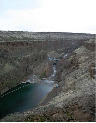
The Opal Springs Project is located on the Lower Crooked River, and within a deep gorge approximately 5 miles southwest of Culver, in Jefferson County, Oregon. The Project is owned by Deschutes Valley Water District which supplies drinking water to the local region. The project is situated roughly 10 miles upstream of the Pelton Round Butte Project (LIHI #25) and downstream of another four hydroelectric projects. The original 6-foot-high diversion dam was built in the 1920s to power a turbine pump. In 1985, the dam was raised 15 feet to its current height.
The project consists of the dam, intake structure, penstock, two irrigation pumps, and a powerhouse with one generating unit. The dam is a 21-foot-high, 200-foot-long concrete capped rockfill diversion dam, controlled with fixed flashboards. The intake structure is a 44-foot by 33-foot, 34-foot-high, rectangular concrete structure. Other project infrastructure includes two 12.5-foot-diameter, 1,157-foot-long, buried, corrugated-metal conduits; a 30-foot-diameter steel surge tank-bifurcator; a 16-foot-diameter, 160-foot-long steel penstock; two existing turbine-driven irrigation pumps; a powerhouse containing one horizontal tube type turbine generating unit with a capacity of 4.3 MW.
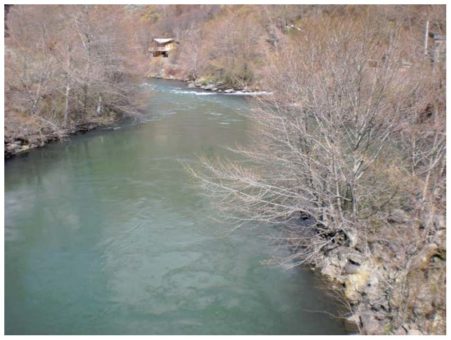
The project operates in a run-of-river mode and creates a 14.4-acre reservoir. The project provides a continuous minimum flow of 50 cfs (or inflow if less) to protect aquatic resources. This flow regime was temporarily modified in consultation with Oregon Department of Fish and Wildlife, US Fish and Wildlife Service (USFWS), and National Marine Fisheries Service to provide attraction flows for migrating adult salmonids.
Waters within the project reach are designated as impaired for exceeding the range of numeric criteria for pH, temperature, E. coli, and aquatic weed/algae development. As a result of water quality monitoring and testing, it has been determined that the project does not contribute to these impairments. Oregon Department of Environmental Quality has confirmed the project is not the cause of the impairments.
In 2015, the project owner applied for a non-capacity license amendment for fish passage facilities. The need for fish passage at the project was driven by the installation of fish passage at the downstream Pelton Round Butte Project. The Pelton Round Butte fish passage created anadromous fish presence at the Opal Springs project. To establish appropriate fish prescriptions, the project owner voluntarily engaged with stakeholders and a multi-party Settlement Agreement was developed in 2015 and amended in 2017.
Fish passage improvements included:
- Construction of a fish ladder to provide passage into the spawning, rearing, and foraging habitats of the Crooked River sub-basin for adult anadromous summer Steelhead, spring Chinook salmon, and migratory bull trout, the latter of which are listed as threatened under the Endangered Species Act (ESA). Additionally, the facilities reconnected populations of native redband trout upstream and downstream of the project. A video of the fish ladder project can be found HERE.
- Raising the maximum operating elevation of the reservoir through addition of a fixed flashboard. This new elevation enabled the owner to construct alternative downstream passage routes for migrating fish and enabled the establishment of a water credit system to supplement flow into the project’s bypass reach and through the fish ladder.
- Modifying the existing roughened spillway by creating a single smooth chute to enable safe, timely, and effective downstream fish passage.
- Establishing a water credit system known as the Bypass Flow Accrual Account. This water serves as both attraction flow for upstream migrating adult fish that may be holding in the project’s tailrace, and as alternative passage for downstream migrants.
- Implementation of a monitoring and evaluation program for assessing upstream and downstream passage relative to stated performance objectives.
- Adaptive management of the project and its operations to meet the fish passage performance objectives.
PLUS-Standard: The fish passage facilities established an adaptive management approach to ensure that both upstream and downstream passage meets the required survival criteria of 90% with a goal of 97%. The voluntary efforts on the part of the project owner, well before the expiration of its FERC license, has made over 100 miles of spawning habitat available upstream of the project.
The project has a small boundary that is surrounded by extremely sloped cliffs, containing no lands of significant ecological value. Wetland surveys were conducted for the Oregon Department of State Lands and US Army Corps of Engineers in 2014 to determine the presence and location of wetlands along the shorelines of the project. The proposed reservoir elevation was found to effect only 0.018 acres of wetland.
Threatened and endangered species potentially within project vicinity include: Northern spotted owl, bull trout, Middle Columbia River steelhead, and Canada lynx. The project does not include critical habitat for the listed species, except bull trout, due to its small boundary. The project is not expected to have any effect on the species as confirmed by USFWS. Mitigation efforts associated with fish passage facilities operate in compliance with bull trout recovery plans and will help to restore riverine connectivity and historic habitat for the species.
Through consultation with the State Historic Preservation Office (SHPO), the project was found to house no historic or cultural resources in the project area. Further consultation with the SHPO concluded that implementation of the fish passage improvement project would not affect any historic properties. Information on the history of the project and the Water District can be found HERE.
Recreational resources at the project include a kayak/canoe ramp, recreational fishing, gravel paths, picnic tables, and restrooms.
PLUS-Standard: The only recreation prescription in the FERC License is the requirement that public access be provided. The owner voluntarily operates and maintains the above facilities in response to whitewater boating activity and the recognition of need for recreational amenities.
An interesting video about the project, fish passage, and fishing can be found HERE.
Compliance Status
The Certificate includes the following facility-specific conditions:
Condition 1: Annual Flow Monitoring Reports will be due upon completion of the fish passage improvements in 2019. The Facility Owner shall provide copies of the reports and summaries of flow monitoring activities in the annual compliance statements submitted to LIHI.
Condition 2: Since the LIHI term will extend beyond the first 5-year review of the fish passage adaptive management program, the Facility Owner shall provide a summary in the annual compliance statements submitted to LIHI of activities related to implementation of the Settlement Agreement’s Fish Passage Protection Plan’s measures; and shall provide to LIHI a copy of results from the first 5-year Performance Assessment Interval, including any agency recommendations for modifications to fish passage facilities or to the monitoring program. LIHI reserves the right to revoke the PLUS standard for fish passage in the event that agencies determine that fish passage Performance Objectives are not being met.
2026: No material changes or compliance issues were identified. The project remains in compliance based on the annual review. For Conditions 1 and 2, annual reports and plans were submitted as was the draft 5-year report, showing that performance objectives were not met and triggering “Tier 1” adaptive management measures – in consultation with agencies.
2025: No material changes or compliance issues were identified. The project remains in compliance based on the annual review. For Conditions 1 and 2, annual reports and plans were submitted. The 5-year performance assessment for Condition 2 was completed.
2024: No material changes or compliance issues were identified. The project remains in compliance based on the annual review. For Conditions 1 and 2, annual reports and plans were submitted.
2023: No material changes or compliance issues were identified. The project remains in compliance based on the annual review. For Conditions 1 and 2, the 2022 annual report and 2023 plan were submitted.
2022: No material changes or compliance issues were identified. The project remains in compliance based on the annual review. For Conditions 1 and 2, the 2021 annual report and 2022 plan were submitted.
2021: There were no reported changes or compliance issues. The project remains in compliance based on the annual review. For Conditions 1 and 2, the 2020 annual report and 2021plan were submitted
2020: There were no reported changes or compliance issues. The project remains in compliance based on the annual review. 2020 was the first year of fish passage operations. For Conditions 1 and 2, the 2019 annual report and 2020 plan were submitted
2019: There were no compliance issues. The project remains in compliance based on the annual review. For Conditions 1 and 2, no changes were reported pending completion of the fishway.
2018: Annual reporting for the current Certificate has not yet taken effect.
Certification History
January 1, 2022: The LIHI Certificate term has been extended in accordance with Revision 2.05 of the LIHI 2nd Edition Certification Handbook issued January 1, 2022. Refer to the facility table above for the new term.
November 13, 2018:The decision to certify the Opal Springs Hydroelectric Project is final. No appeals were received during the appeal period which closed on November 8, 2018. The new certification term for the Project is from April 25, 2018 through April 24, 2028.
October 9, 2018: On October 8, 2018, the Low Impact Hydropower Institute (LIHI) preliminarily approved Low Impact Certification for the Opal Springs Hydroelectric Project. This decision is preliminary pending the 30-day appeal window. Only those who commented on the initial application during the 60-day comment period are eligible to file an appeal. Such appeal needs to include an explanation as to how the Project does not meet the LIHI criteria. Appeal requests can be submitted by email to comments@lowimpacthydro.org with “Opal Springs Hydroelectric Project” in the subject line, or by mail addressed to the Low Impact Hydropower Institute, 329 Massachusetts Ave, Suite 2, Lexington, MA 02420. All requests will be posted to the website. The applicant will have an opportunity to respond and any response will also be posted. Requests must be received by 5 pm Eastern time on November 8, 2018. If no appeal requests are received and the decision becomes final, the Certification term for the Opal Springs Project (pending LIHI # 145) will be April 25, 2018 through April 24, 2028.
May 1, 2018: The Low Impact Hydropower Institute (LIHI) has received a complete application from the Deschutes Valley Water District for the Low Impact Certification of the Opal Springs Hydroelectric Project (FERC No. 5891). The project dam is located at river mile 7.0 on the Crooked River a tributary to the Deschutes River in the town of Culver, Jefferson County, Oregon. LIHI is seeking comment on the Opal Springs application for certification. Comments that are directly tied to specific LIHI criteria (flows, water quality, fish passage, etc.) will be most helpful, but all comments will be considered. Comments may be submitted to the Institute by e-mail at comments@lowimpacthydro.org with “Opal Springs Comments” in the subject line, or by mail addressed to the Low Impact Hydropower Institute, 329 Massachusetts Avenue, Suite 2, Lexington, MA 02420. Comments must be received at the Institute on or before 5 pm Eastern time on June 30, 2018 to be considered. All comments will be posted to the web site and the applicant will have an opportunity to respond. Any response will also be posted.
Certification Files
2018 Certification
- Opal Springs Certification Review Report 2018
- Opal Springs Certification Application 2018
- Opal Springs Certification Application Supplemental Information 2018
Key Documents
- Opal Springs FERC Amendment 2018
- Opal Springs Environmental Assessment Revision 2017
- Opal Springs Water Quality Certificate Amended 2017
- Opal Springs Water Quality Certificate 2016
- Opal Springs Fish Passage Settlement Agreement 2015
- Opal Springs Environmental Assessment 2015
- Opal Springs FERC License 1982