LIHI Certificate #205 - Newbury Project, Vermont
| Project Name | Newbury |
| LIHI Certificate No. |
205 |
| LIHI Certificate Term |
July 9, 2025 to July 8, 2035 |
| Owner | Green Mountain Power Corp. |
| State | Vermont |
| Location | River Mile 0.9 on the Wells River |
| Installed Capacity | 0.365 MW |
| Average Annual Generation | 882 MWh |
| Facility Type | Run-of-river |
| FERC No. | P-5261 issued March 28, 2024; expires 02/29/2064 |
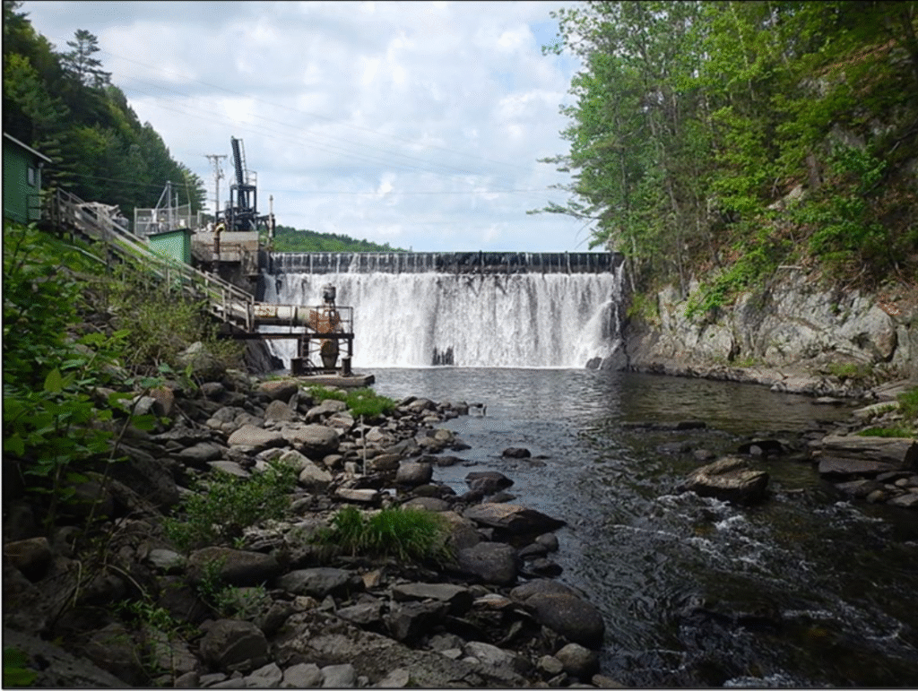
The Newbury Hydroelectric Project is located on the Wells River, in the Village of Wells River, Town of Newbury, in Orange County, Vermont. The Project is located approximately 0.9 river miles from the Wells River’s confluence with the Connecticut River. Originally built in 1912, the dam is a concrete, gravity-type structure that is 90 feet long by 26 feet high with a south abutment crest at 464.9 feet National Geodetic Vertical Datum (NGVD 29) and a north abutment crest at 464.4 feet NGVD 29. The spillway is 73.3 feet long by approximately 20 feet high and topped with a 5-foot-high and 73.3-foot-long pneumatic crest gate system. The spillway crest elevation is 458.9 feet NGVD 29, and the normal impoundment level is 463.9 feet NGVD 29 with the crest gate system inflated. The dam creates a bypassed reach approximately 590 feet long, and the impoundment is approximately 0.4 miles in length and covers a surface area of 11.4 acres at full pond, with 25 acre-feet of gross storage capacity.
Additional project facilities include: a 5-foot-diameter, 435-foot-long underground steel penstock; an intake structure; a powerhouse located within the former Adams Paper Company mill building containing a single turbine-generator unit (Unit No. 1) rated at 0.315 MW and a minimum flow unit (Unit No. 2) located approximately 75 feet downstream of the dam rated at 0.05 MW; a tailrace; three 150-foot-long generator leads creating a 480 Volt (V), 3-phase, 150-foot-long underground transmission line connecting to three pole-mounted 167 kVA3 step-up transformers; appurtenant facilities.
The project operates in a run-of-river mode where outflow approximates inflow and managed in accordance with a Flow Management and Monitoring Plan. The bypassed reach receives 37 cfs, or inflow if less, year-round. This minimum flow includes 10 cfs spilled over the spillway for aesthetic purposes. The Project’s minimum flow unit provides 30 cfs of the required minimum flow, with the additional minimum flow of 7 cfs being met by a 10-cfs aesthetic spill. The minimum flow unit is operated in an “on” or “off” mode, such that if less than 30 cfs is available to operate, the unit is shut
down and all inflow is spilled over the spillway.
The waters in the project reach are not listed as impaired by the State of Vermont, and water quality monitoring demonstrated that the Wells River attained the standards for Class B(2) waters suitable for swimming and other primary contact recreation; irrigation and agricultural uses; aquatic biota and aquatic habitat; good aesthetic value; boating, fishing, and other recreational uses and suitable for public water source with filtration and disinfection or other required treatment.
There are no migratory fish in the project area due to downstream barriers on the Connecticut River. However, the project’s water quality certification and FERC license include provisions for American eel passage plans dependent on the timing of eel passage facilities installed at Wilder dam on the Connecticut River. The project’s downstream fish passage facility consists of a spillway chute which operates from April 1st to June 1st with a flow of 20 cfs, and from September 1st to November 15th with a flow of 10 cfs as spillage over the dam for aesthetics and minimum flow.
The shoreline around the impoundment is approximately 1 mile in length, with the southern portion made up of vegetation and riprap, and the northern portion being primarily forested with large areas of steeply sloped ledge outcrops. Run-of-river operations limit the potential for shoreline erosion although maintenance drawdowns could have a minor impact although they rare due to the pneumatic crest gate system to facilitate management of stable impoundment levels.
Threatened and endangered species that may be present include northern long-eared bat and the proposed-for-listing tri-colored bat, but there are no known winter hibernacula or summer maternity roost sites near the project. The proposed-for-listing monarch butterfly and the protected bald eagle may also be present. Given the small land footprint of 3.4 acres and lack of need for tree cutting or non-routine vegetation management, it is unlikely that the project impacts protected species.
Cultural and historic resources at the project include structural remains of the 1896-1938 Wells River Electric Light Plant and Pumping Station which been recommended as eligible for the National Register of Historic Places (NRHP), however due to a lack of historic and architectural significance, the hydro project structures are not eligible for inclusion. The project operates under a Historic Properties Management plan which requires consultation with the State Historic Preservation Office as needed.
The owner leases the project land and powerhouse area from a private landowner. There are currently no Project recreation facilities associated with the project. Recreational development at the site has not previously been pursued because of high, steep banks on the river left shoreline, proximity of U.S. Route 302 along the river right shoreline, and commercial use of the parking lot associated with the Project dam and powerhouse area. The owner is evaluating the potential for development of recreational access in the form of a hand-carry boating access area on the impoundment.
Compliance Status
The Certificate includes the following facility-specific conditions:
Condition 1: In annual compliance submittals to LIHI, the Facility Owner will provide an update on the status of FERC’s approval of the Flow Management and Monitoring Plan and any additional conditions required therein along with a schedule for implementation, if applicable, until all actions related to the Plan are implemented and approved by FERC.
Condition 2: In annual compliance submittals to LIHI, the Facility Owner will provide a status update on the development and implementation of the boating access plan including documentation of agency and stakeholder consultation, until the access area is completed and approved by FERC.
2025: Annual reporting for the current Certificate has not yet taken effect.
Certification History
October 31, 2025: The Low Impact Hydropower Institute has issued a final decision on the certification of the Newbury Hydroelectric Project. No appeals were received during the appeal period which closed on October 30, 2025. The 10-year certification term is July 9, 2025 through July 8, 2035.
September 30, 2025: The Low Impact Hydropower Institute (LIHI) has preliminarily approved Low Impact Certification for the Newbury Hydroelectric Project, (pending LIHI #205). The full application and reviewer’s report are available below.
This decision is preliminary pending the 30-day appeal window. Only those who commented on the initial applications during the 60-day comment period are eligible to file an appeal. Such appeal needs to include an explanation as to how the Projects do not meet the LIHI criteria. Appeal requests can be submitted by email to comments@lowimpacthydro.org with “Newbury Project” in the subject line, or by mail addressed to the Low Impact Hydropower Institute, 68 Harrison Ave Ste 605, PMB 113938 Boston, Massachusetts 02111-1929. All requests will be posted to the website. The applicant will have an opportunity to respond and any response will also be posted. Requests must be received by 5 pm Eastern time on October 30, 2025. If no appeal requests are received the certification term will be July 9, 2025 through July 8, 2035.
July 10, 2025: The Low Impact Hydropower Institute has received a complete application for Low Impact Certification of the Newbury Hydroelectric Project. LIHI is seeking public comment on this application. Specifically, we are interested in knowing whether you think the Project meets the LIHI Low Impact Certification Criteria, as revised in the 2nd Edition Handbook in effect at the time of initial application. Please review the program and criteria in LIHI’s Handbook Revision 2.05 (the handbook version in effect at the time of initial draft application) and then review the Project’s application materials below. Comments that are directly tied to specific LIHI criteria (flows, water quality, fish passage, etc.) will be most helpful, but all comments will be considered. Comments may be submitted to the Institute by e-mail at comments@lowimpacthydro.org with “Newbury Project Comments” in the subject line, or by mail addressed to the Low Impact Hydropower Institute, 68 Harrison Ave Ste 605, PMB 113938 Boston, Massachusetts 02111-1929. Comments must be received on or before 5 pm Eastern time on September 8, 2025 to be considered. All comments will be posted to the web site and the applicant will have an opportunity to respond. Any response will also be posted.