LIHI 证书 #169 - 缅因州白内障项目
| 项目名称 | 白内障 |
| LIHI 证书编号 | 169 |
| LIHI 证书期限 | 2020年4月3日 – 2030年4月2日 |
| 所有者 | Brookfield White Pine Hydro, LLC,是 Brookfield 可再生能源集团的子公司 |
| 状态 | 缅因州 |
| 地点 | 萨科河 6.0 英里和 6.3 英里之间 |
| 装机容量 | 6.65 兆瓦 |
| 平均年发电量 | 30,868 兆瓦时 |
| 设施类型 | 河流径流 |
| 联邦能源管理委员会 不。 | 2528,1989 年签发,有效期至 2029 年 11 月 30 日 |
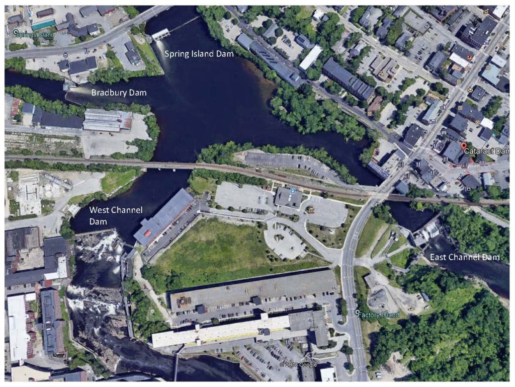
卡塔拉特水电项目位于缅因州萨科河上,涵盖萨科市、比迪福德市以及代顿镇和巴克斯顿镇。该项目由四个开发项目组成——春岛坝、布拉德伯里坝、东水道坝和西水道坝(从上游到下游)。春岛坝、布拉德伯里坝和西水道坝的建造时间早于1938年建成的东水道坝。这些大坝最初建于20世纪初,旨在满足萨科河沿岸工业的水力机械和水力发电需求。萨科河是缅因州第四大河流,发源于新罕布什尔州,流经缅因州134英里,最终汇入萨科湾。卡塔拉特项目是萨科河上七个水力发电大坝中的第一个,其他七个大坝包括 邦尼鹰 (LIHI #182).
该项目包括四个开发项目、两个蓄水池和一个 发电站.项目工作包括:
- 春岛: 春岛 坝 由天然的类似物组成 鱼道 约100英尺宽,230英尺长,始于东岸,包含一个溢流段和两个闸门段。溢流段为混凝土重力结构,顶部有18英寸销钉支撑 闪光板,从自然鱼道延伸至第一道闸门段,长117.5英尺。闸门房设有四个闸门开口。有三个Tainter 门每个洞口宽16英尺,高11英尺。最东边的洞口用木材封闭。 停止日志 以及一个用链式葫芦手动操作的滑动闸门。闸门部分西侧是用于上游的船闸系统 鱼道。船闸系统长约 41 英尺,宽约 10 英尺,包含一个 吸引力流 水槽、集鱼器、船闸室、控制闸门和出口通道。泉岛没有发电。
- 布拉德伯里:布拉德伯里大坝由一座从南岸延伸的混凝土重力溢流结构组成,其中包括一个闸门部分。 泄洪道 闸门段长141英尺,配有20英寸高的销式挡水板,与闸门段相邻。闸门段包含一个20.25英尺宽、13.5英尺高的Tainter闸门。闸门段北侧是用于上游鱼类通行的船闸系统。船闸系统长约41英尺,宽约10英尺,包含一个引流水槽、一个集鱼器、船闸室、控制闸门和出口通道。布拉德伯里不发电。
- 西水道:西水道大坝由两个溢流段、一个下游鱼道堰、一个上游德尼尔鱼梯和一个闸门段组成。第一个溢流段为重力式结构,由石砌混凝土构成,并设有混凝土盖板。该段从西岸延伸至一个拐角处,长193英尺(约58米),从拐角处延伸至原鱼道,长44.5英尺(约13.7米)。该溢流段配备了一个4英尺(约1.2米)高的充气橡胶气囊。第二个溢流段从闸门段延伸至德尼尔鱼梯和下游鱼闸。该段为混凝土重力式结构,长24英尺(约7.3米),配有4英尺(约1.2米)高的销钉支撑式闸板。西水道上游航道 坝 是通过德尼尔鱼梯。该地点还设有分类设施。德尼尔鱼梯宽4英尺,长约550英尺。垂直上升高度约为44英尺,垂直坡度为1比8。西水道中过时的缺口堰和孔口鱼道自1991年以来已被废弃。下游水道由一个带闸门的水槽组成。西水道不发电。
- 东水道:东水道大坝由溢流段、闸门段和进水段组成。溢流段为88英尺8英寸长的混凝土重力坝,顶部为5英尺高的充气式 顶门顶闸由位于发电站进水口上方的一座小型控制楼控制。东航道闸门段包含一座垂直升降式布鲁姆闸门,宽20英尺,高15英尺。发电站进水口段宽49.25英尺,配有齿条和两个进水口。发电站位于东航道的工厂岛。下部结构安装有一台9,000马力的卡普兰S.摩根史密斯水轮机。 导流管 与进水口呈约 20 度角,从下部结构向下游延伸 30 英尺,然后排入潮水。尾水管下游端安装了两个闸门,每个闸门宽 15 英尺,高 12.8 英尺。发电厂上部结构为钢结构和砖结构,内设一台 6.65 兆瓦发电机和相关设备。安装了一台 60 吨容量的桥式起重机为机组提供服务。东水道坝设有上游通道,配有升鱼机。设施包括分类和陷阱/卡车供应。升鱼机从潮池垂直移动到约 44 英尺高的源池。一条 337 英尺长、8 英尺宽的水槽向上游延伸至分类设施和源池。分类设施包括陷阱和卡车运输措施。下游通道由一个带门的水槽组成。
该项目运营于 径流 模式,并蓄水两座水库。春岛/布拉德伯里蓄水池水面面积约为359英亩,延伸至上游的斯凯尔顿项目(FERC编号2527)。西水道和东水道蓄水池占地约14英亩,并向上游延伸至春岛和布拉德伯里水坝。 基流 根据美国鱼类及野生动物管理局 (USFWS)、缅因州内陆渔业和野生动物部 (MDIFW)、美国国家海洋渔业局 (NMFS) 和缅因州环境保护部 (MDEP) 的建议,在东、西水道开发项目下方提供 851 立方英尺/秒的供水量。此流量建议基于历史上未受管制的 8 月份中值流量 (水生基流萨科河此段。此外,西水道下游鱼道在4月1日至12月31日期间(视情况而定)持续提供52立方英尺/秒的流量,上游德尼尔鱼道则全年提供50立方英尺/秒的流量。东水道上游鱼道持续提供120立方英尺/秒的流量。
项目流域内的水域被指定为B类水域,而Spring Island/Bradbury蓄水池的最上游被指定为A类水域。B类水域经处理后,适合饮用水供应、渔业、初级和 二次接触娱乐以及鱼类/水生栖息地。MDEP 2018 年缅因州水域拟议重新分类并未将该河段认定为不符合任何水质标准。
萨科河目前支持 洄游性 鱼类物种包括美洲鳗、大西洋鲑、河鲱和美洲西鲱。上述通道设施支持这些物种的上游和下游通行。这些通道设施由美国鱼类及野生动物管理局 (USFWS)、缅因州渔业和野生动物部 (MDIFW)、美国国家海洋渔业局 (NMFS)、缅因州海洋资源部和缅因州大西洋洄游鲑鱼委员会合作设计。该项目已于9月和10月实施夜间关闭,以方便美洲鳗下游通行。
项目用地仅限于包含项目建筑的土地。项目周边为商业和公寓楼密集的区域。 径流式 运营减轻了对海岸线的影响,并且项目边界内不存在具有重大生态价值的土地。
项目附近可能存在的受威胁或濒危物种包括大西洋鲟鱼、短鼻鲟、北方长耳蝠、环颈鸻、红腹滨鹬和小轮纹鹬。目前尚未在项目附近发现鲟鱼物种的关键栖息地,但项目业主正在与美国国家海洋和渔业局 (NMFS) 协商,以确保该项目能够妥善满足这两种鲟鱼的需求。与美国鱼类及野生动物管理局 (USFWS) 的协商并未在项目区域内发现任何蝙蝠冬眠地或产房栖息地。环颈鸻和红腹滨鹬以及小轮纹鹬可能出现在项目下游的潮汐河段。径流式作业降低了对这些物种产生任何影响的可能性。小轮纹鹬是高地物种,在项目边界内不太可能发现。
项目周边支持列入 国家历史遗迹名录 以及项目附近工厂岛上的工厂建筑均符合列入名录的条件。这11处考古遗址可能可以追溯到1630年,当时欧洲人首次在这条河上定居。在项目边界进行任何扰动地面的活动之前,必须咨询州历史保护办公室 (SHPO)。SHPO 还指出,项目的持续运营不会对任何已列入名录的财产或可能符合列入国家历史保护名录资格的财产产生不利影响。
该项目的娱乐资源包括:
- 钻石河畔 (Diamond Riverside) 船坞位于春岛 (Spring Island) 和布拉德伯里 (Bradbury) 水坝上游,由萨科市拥有和运营。免费向公众开放。
- 扶轮公园海滩 (Rotary Park Beach) 是市政府拥有并运营的海滩区,位于春岛 (Spring Island) 和布拉德伯里 (Bradbury) 开发区的上游。为居民提供停车位。
- 东水道开发区附近有一条公共小道,可供钓鱼。
- 项目尾水区东侧设有一条钓鱼小径。该小径向公众开放,停车场位于萨科市中心。
入口位于 Cataract 项目和上游 Skelton 项目中间。 - 普尔斯岛是位于东水道大坝上方、春岛大坝下方的公共休闲区。一座带顶棚的人行桥通往这座小岛,可供野餐和其他日间活动。该区域禁止划船或进行水上娱乐活动。
- 东水道大坝下方的河流东侧设有一个船只下水处。公众可免费使用。
合规状态
该证书包括以下针对设施的特定条件:
2025年完全满足,2021年部分满足。 条件 1: 设施所有者应向 LIHI 提供文件,证明西通道 导流 东水道鱼道入口处的防洪墙和水槽延伸部分应不迟于 2021 年 5 月 1 日完工并投入使用;如果届时仍未完工,业主应提供项目状况报告,包括资源机构咨询和项目完成时间表。
2025: 未发现任何重大变更或合规问题。根据年度审查,该项目仍然合规。对于条件1,该项目报告东航道建设已完工,因此满足条件。该项目于2024年开始申请联邦能源管理委员会(FERC)的重新许可。
2024: 未发现任何重大变更或合规问题。根据年度审查,该项目仍然合规。对于条件1,该项目报告称东航道建设于2023年开始,但由于流量大而推迟。预计2024年竣工。
2023: 未发现任何重大变更或合规问题。根据年度审查,该项目仍然合规。对于条件1,项目报告称东航道建设无法在2022年完工,但预计将于2023年完工,为2024年的迁徙季节和试运行做好准备。目前计划在2025年进行遥测研究。
2022: 未发现任何重大变更或合规问题。根据年度审查,该项目仍然合规。对于条件1,项目报告称东航道90%鱼道设计已于2022年初完成。预计2022年开工,2023年进行试运行,2024年进行遥测研究。
2021: 该项目未出现任何合规问题。根据年度审查,该项目仍然合规。项目报告称,仿自然鱼道已于2019年竣工。对于条件1,项目报告称,西航道导流墙已于2020年竣工,因此部分满足条件。东航道鱼道设计有所延迟,但预计将于2021年完工。
2020: 当前证书的年度报告尚未生效。
认证历史
2022 年 1 月 1 日: LIHI 证书期限已根据 2022 年 1 月 1 日发布的 LIHI 第 2 版认证手册 2.05 版延长。有关新期限,请参阅上面的设施表。
2020 年 7 月 30 日: 2020 年 7 月 22 日上诉期结束后,认证白内障项目的决定成为最终决定,没有提出上诉。认证期限为 2020 年 4 月 3 日至 2025 年 4 月 2 日。
2020 年 6 月 22 日: 低影响水电研究所已初步批准位于缅因州萨科镇和比迪福德镇萨科河上的卡塔拉特水电项目(LIHI #169)获得低影响认证。该认证尚待30天的申诉期过后才能进行初步审核。只有在60天的评论期内对初始申请发表意见的人员才有资格提出申诉。此类申诉需要解释该项目为何不符合LIHI标准。申诉请求可以通过电子邮件发送至 comments@lowimpacthydro.org 请在邮件主题中注明“Cataract 水电项目”,或邮寄至低影响水电研究所,地址:329 Massachusetts Ave, Suite 6, Lexington, MA 02420。所有申请都将发布在网站上。申请人将有机会回复,回复也将发布。 请求必须在 2020 年 7 月 22 日东部时间下午 5 点之前收到。 完整的申请和审核报告如下。如果没有收到申诉请求且决定生效,则该项目的认证期限为2020年4月3日至2025年4月2日。
2020年4月7日: 低影响水电研究所 (LIHI) 已收到 Cataract 水电项目低影响认证的完整申请。该项目的申请材料如下。LIHI 正在就此申请征询公众意见。与 LIHI 具体标准(流量、水质、鱼类通道等)直接相关的意见将非常有帮助,但所有意见都会被考虑。意见可通过电子邮件提交至研究所: comments@lowimpacthydro.org 主题行为“Cataract 项目评论”,或邮寄至 Low Impact Hydropower Institute, 329 Massachusetts Avenue, Suite 6, Lexington, MA 02420。 评论必须在东部时间下午 5 点或之前收到 2020 年 6 月 6 日 予以考虑。所有评论都将发布到网站上,申请人将有机会作出回应。任何回应也将发布。