Solicitud pendiente - Proyecto de Tannery Island, Nueva York
| Nombre del proyecto | Isla de la curtiduría |
| Certificado LIHI No. |
n / A |
| Plazo del certificado LIHI |
n / A |
| Dueño | Tannery Island Hydro, LLC, una subsidiaria de Relevate Power |
| Estado | Nueva York |
| Ubicación | Milla fluvial 33,1 en el río Negro en Carthage y West Carthage, NY |
| Capacidad instalada | 1.875 MW |
| Generación media anual | 7.468 MWh |
| Tipo de instalación | De pasada |
| Comisión Federal de Comercio No. | P-4908 exención Emitido el 7 de junio de 1982 (reinstalado el 11 de julio de 1983) |
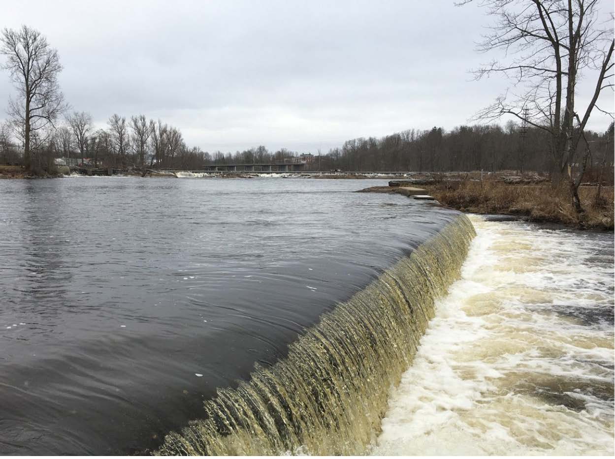
El Proyecto Hidroeléctrico de Tannery Island se ubica en la milla fluvial 33.1 del río Negro, en Nueva York. El río Negro está fuertemente regulado, con 21 presas a lo largo de su recorrido y varios embalses que alimentan la Barcaza del Estado de Nueva York. Canal Sistema. El proyecto se encuentra muy cerca de las fábricas de papel de Cartago (Carthage PMM). Presa (FERC No. 10887), la presa Carthage Mill (West End) (FERC No. 5800) y la presa Long Falls (FERC No. 4636). Las presas aguas abajo incluyen la Proyecto Río Negro/Isla Beebee (LIHI #34) ubicado entre la milla del río 27.5 y la milla del río 9.
El proyecto consta de tres presas, cada una de las cuales dirige una parte del caudal de entrada hacia el central eléctrica cámara de carga:
- La presa de curtiduría “A” es una estructura de gravedad de hormigón aliviadero de aproximadamente 117 pies de largo integrado a la cámara de carga a través de un canal artificial con un muro de ala de gravedad de 63 pies de largo que forma la pared del compartimiento de carga de la central eléctrica y un muro de ala de gravedad de 50 pies de largo que funciona como presa’al este contrafuerte.
- Las dos estructuras restantes, conocidas como presas del estanque Spicer, son presas de gravedad de hormigón. aliviaderos con elevaciones de cresta irregulares.
- La presa “B” (presa Little Spicer) se extiende por las islas Tannery y Wind y tiene aproximadamente 106 pies de largo, coronada estacionalmente con 1 pie. tableros de flash (con tres aberturas de flujo mínimo de diferentes anchos).
- La presa "C" (Presa Big Spicer) se extiende aproximadamente 85 metros entre Wind y Devil Island, y está rematada estacionalmente con zanjas de 30 centímetros (con cinco aberturas de flujo mínimo de diferentes anchos). La presa "C" también incluye un muro de contención inclinado hacia la presa Carthage Paper Makers Mill (Carthage PMM), aguas arriba, que tiene 30 metros de longitud. La altura de las presas varía entre 0,6 y 1,8 metros.
El embalse es el tramo de descarga/derivación de la presa Carthage PMM. Las presas de Tannery Island crean un tramo de derivación insignificante que desemboca directamente en el embalse de la presa Carthage Mill (West End).
La central eléctrica es una estructura de canal abierto que contiene cinco turbinas/generadores sumergibles Flygt. De las cinco turbinas, tres son de hélices fijas y dos tienen palas ajustables. Con placas de expansión de 30 cm (12 pulgadas), cada unidad produce aproximadamente 375 kW netos. cabeza de 15,8 pies, lo que resulta en una capacidad instalada total de 1.875 kW para toda la instalación. Consumo Los estantes para basura tienen un espacio libre de 2 pulgadas.
El proyecto es una instalación de pasada con una elevación mínima del estanque variable según la temporada y una superficie de aproximadamente 8,5 acres con una capacidad bruta de almacenamiento de aproximadamente 68 acres-pie. Los caudales del río que desembocan en el río Negro desde aguas arriba están regulados por la Distrito Regulador del Río Hudson-Río Negro. La central eléctrica y el aliviadero descargan en un canal de descarga de aproximadamente 700 pies de largo que se fusiona con los flujos del tramo de derivación hacia el embalse de las presas Long Falls y Carthage Mill (West End).
No existe un caudal mínimo requerido por la FERC, pero el propietario del proyecto acordó proporcionar 106 pies cúbicos por segundo de caudal mínimo que NYSDEC determinó que es suficiente para soportar los niveles de oxígeno disuelto y los hábitats acuáticos río abajo. Tableros de flash Se instalan estacionalmente desde aproximadamente el 15 de abril al 17 de diciembre en la Presa “B” y la Presa “C”, con múltiples muescas de caudal mínimo.
Las aguas en el tramo del proyecto se consideran aguas de Clase C, aptas para los usos designados de: reproducción de peces, mariscos y fauna silvestre, pesca y recreación de contacto primario y secundario. El Estado de Nueva York no clasifica las aguas del proyecto como contaminadas.
No hay especies migratorias de peces en las inmediaciones del proyecto, y existen barreras para la migración río abajo en Watertown, NY, en las cataratas de Mill Street. No hay aguas arriba. paso de peces Se requiere o se proporciona. Las especies residentes incluyen la perca de calabaza, la lobina de boca chica, el pez carite, la perca amarilla, la perca de roca, el lucio y la lucioperca americana. El paso aguas abajo de estas especies se facilita mediante los caudales mínimos y el vertido de las presas.
Los terrenos del proyecto son muy pequeños y consisten en 8.5 acres de agua y menos de un acre de tierra. El límite del proyecto abarca las presas y la central eléctrica, y solo sigue una parte de la costa del embalse. Los terrenos también incluyen pequeñas porciones de las islas Wind y Tannery. El área circundante al proyecto está urbanizada con zonas comerciales e industriales, y carreteras sin importancia ecológica.
Las únicas especies amenazadas o en peligro de extinción presentes, o que podrían estarlo, son el murciélago de Indiana y el murciélago orejudo norteño (ambos están catalogados a nivel federal y estatal). Dada la pequeña huella del proyecto y la falta de posibles árboles de descanso, es poco probable que afecte a estas especies.
No existen sitios arqueológicos ni históricos documentados dentro de los límites del proyecto y ninguna de las estructuras del proyecto está inscrita en el Registro Nacional de Bienes Históricos, aunque debido a su antigüedad, algunas podrían ser elegibles. El propietario del proyecto contactó recientemente a tribus indígenas reconocidas a nivel federal, pero no ha recibido respuesta. No se conocen ni se han identificado bienes culturales tradicionales dentro del área del proyecto.
No existen instalaciones recreativas específicas para el proyecto aprobadas por la FERC ni puntos de acceso en el proyecto. El área circundante está altamente industrializada y comprende varias presas y potencias y sería inseguro para la recreación acuática. El acceso informal al embalse, canal de descarga y tramos de derivación podría obtenerse a través de Tannery Island, donde se encuentra la central eléctrica, a la que se puede acceder por vías públicas. Hay tres sitios de recreación que brindan oportunidades terrestres adyacentes al proyecto: Long Falls Park. El parque, propiedad de la ciudad de Carthage, ofrece estacionamiento, un sendero para caminar y vistas panorámicas del río Black, incluidas las presas "B" y "C" de Tannery Island. El embarcadero de West Carthage también es propiedad de la ciudad y cuenta con estacionamiento y un embarcadero pavimentado con muelle de cortesía, bancos e instalaciones para picnic, y proporciona acceso a la costa del río Black. El acceso público más cercano al río Black está aguas abajo de Carthage Mill (West End) y las presas de Long Falls en el embarcadero de West Carthage. Long Falls Hydro Rec Site ofrece estacionamiento, áreas de picnic, un pequeño sendero y acceso a la costa al tramo de derivación de Long Falls y Carthage Mill (West End) y al canal de descarga de Long Falls. Es propiedad del proyecto Long Falls y es mantenido por este.
Historial de certificaciones
23 de enero de 2026 El Instituto de Energía Hidroeléctrica de Bajo Impacto (LIHI) ha recibido una solicitud completa para la Certificación de Bajo Impacto del Proyecto Hidroeléctrico de Tannery Island. LIHI solicita comentarios públicos sobre esta solicitud. En concreto, nos interesa saber si considera que el Proyecto cumple con los Criterios de Certificación de Bajo Impacto de LIHI, revisados en la 2.ª edición del Manual vigente al momento de la solicitud inicial. Por favor, revise el programa y los criterios en el sitio web de LIHI. Revisión del manual 2.06 y luego revise los materiales de solicitud del Proyecto a continuación.
Los comentarios que estén directamente relacionados con criterios específicos del LIHI (caudales, calidad del agua, paso de peces, etc.) serán de gran ayuda, pero se tendrán en cuenta todos los comentarios. Los comentarios pueden enviarse al Instituto por correo electrónico a comments@lowimpacthydro.org con “Comentarios sobre el Proyecto Tannery Island” en la línea de asunto, o por correo dirigido al Low Impact Hydropower Institute, 68 Harrison Ave Ste 605, PMB 113938 Boston, Massachusetts 02111-1929. Los comentarios deben recibirse antes de las 5 p. m., hora del Este, el 24 de marzo de 2026. Se considerarán todos los comentarios. Se publicarán en el sitio web y el solicitante tendrá la oportunidad de responder. También se publicarán todas las respuestas.
Archivos de certificación
Solicitud 2026
Documentos clave
- Isla Tannery FERC Exención Enmienda de 1997
- Evaluación ambiental de la FERC de Tannery Island para la enmienda de 1997
- Solicitud de exención de Tannery Island de 1981
- Restablecimiento de la exención por parte de la FERC en 1983
- Sentencia del Tribunal sobre exención de 1983
- Orden de la FERC de anular la exención de 1982