Hailesboro No. 3, 4, 6 Projects - Complete Application Received
May 4, 2023: The Low Impact Hydropower Institute has preliminarily approved Low Impact Certification for the Hailesboro No. 3, No. 4 and No. 6 Hydroelectric Projects. The full application and reviewer's report are available below.
This decision is preliminary pending the 30-day appeal window. Only those who commented on the initial applications during the 60-day comment period are eligible to file an appeal. Such appeal needs to include an explanation as to how the Projects do not meet the LIHI criteria. Appeal requests can be submitted by email to comments@lowimpacthydro.org with "Hailesboro Projects” in the subject line, or by mail addressed to the Low Impact Hydropower Institute, 1167 Massachusetts Ave, Arlington, MA 02476. All requests will be posted to the website. The applicant will have an opportunity to respond and any response will also be posted. Requests must be received by 5 pm Eastern time on June 3, 2023.
If no appeal requests are received the certification terms will be February 3, 2023 through February 2, 2033.
February 7, 2023: The Low Impact Hydropower Institute has received a complete application for Low Impact Certification of the Hailesboro No. 3, 4, & 6 Hydroelectric Project. LIHI is seeking public comment on this application. Specifically, we are interested in knowing whether you think the Project meets the LIHI Low Impact Certification Criteria, as revised in the 2nd Edition Handbook. Please review the program and criteria in LIHI’s revised Handbook and then review the Project’s application materials below.
Comments that are directly tied to specific LIHI criteria (flows, water quality, fish passage, etc.) will be most helpful, but all comments will be considered. Comments may be submitted to the Institute by e-mail at comments@lowimpacthydro.org with “Hailesboro 3, 4, & 6 Project Comments” in the subject line, or by mail addressed to the Low Impact Hydropower Institute, 1167 Massachusetts Avenue, Arlington, MA 02476. Comments must be received on or before 5 pm Eastern time on April 8, 2023 to be considered. All comments will be posted to the web site and the applicant will have an opportunity to respond. Any response will also be posted.
| Project Name | Hailesboro No. 3, 4, & 6 |
| LIHI Certificate No. |
Pending # 197, 198, 199 |
| LIHI Certificate Term |
February 3, 2023 – February 2, 2033 |
| Owner | Hydro Development Group Acquisition, LLC
a subsidiary of Patriot Hydro. LLC |
| State | New York |
| Location | No. 3 – River mile 67.5, No. 4 – River mile 67.7, No. 6 – River Mile 68 on the Oswegatchie River, St. Lawrence County, New York |
| Installed Capacity | No. 3: 1 MW
No. 4: 1.9 MW No. 6: 0.9 MW |
| Average Annual Generation | No. 3: 3,993 MWh
No. 4: 10,647 MWh No. 6: 4,728 MWh |
| Facility Type | Run of river |
| FERC No. | No. 3: P-5633. Exemption issued July 14, 1982, amended June 11, 1998.
No. 4: P-6058. Issued October 30, 2002, expiring December 31, 2032. No. 6: P-3181. Exemption issued September 17, 1981. |
The Hailesboro No. 6 Hydroelectric Project (FERC No. 3181), Hailesboro No. 4 Hydroelectric Project (FERC No. 6058), and Hailesboro No. 3 Hydroelectric Project (FERC No. 5633), collectively referred to as the Hailesboro Projects, are located on the Oswegatchie River in St. Lawrence County, New York. The Projects are owned and operated by Hydro Development Group Acquisition, LLC (HDGA). The 132-mile long Oswegatchie River is located in the St. Lawrence River Watershed.
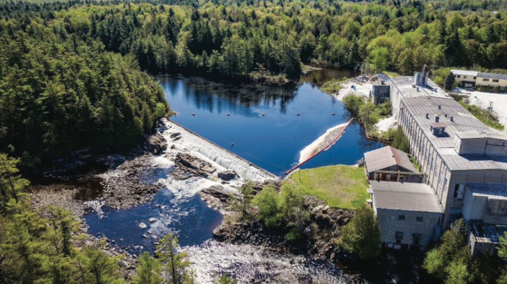
The Hailesboro No. 6 Project is the most upstream of the three Projects and is located at river mile (RM) 68.2. The Project operates under an exemption issued by the Federal Energy Regulatory Commission on September 17, 1981.
The Project consists of (1) a 10-foot-high and 150-foot-long reinforced concrete gravity overflow-type dam with a crest elevation of 487 ft National Geodetic Vertical Datum (NGVD); (2) a reservoir with a surface area of 4 acres and negligible storage capacity at normal surface elevation of 487 feet NGVD; (3) a 40-foot-wide and 70-foot-long intake structure with gates and trashracks along the south (left) bank; (4) a powerhouse containing two turbines rated at 800 horsepower and 500 horsepower, connected to two generators rated at 550 kilowatts (kW) and 350 kW, respectively, at a head of 19 feet and at a flow of 700 cubic feet per second (cfs); (5) a short tailrace; (6) electrical switchgear; (7) a 75-foot-long 2.3-kilovolt (kV) transmission line; and (8) appurtenant facilities. Hailesboro No. 6 has an installed capacity of 900 kW and operates in a run-of-river (ROR) mode. The dam creates a short bypassed reach, approximately 350 feet long.
The Hailesboro No. 4 Project is located at RM 67.7, approximately 0.5 miles downstream from Hailesboro No. 6. The Project operates under a license issued by FERC on October 30, 2002, which was amended on September 19, 2012. The Project consists of (1) a concrete gravity-type dam comprised of: (i) the 105-foot-long, 14-foot-high dam #1 surmounted by a 2-foot-high pneumatic crest gate; and (ii) the 58-foot-long, 5-foot-high dam #2 surmounted by 2-foot-high wooden flashboards; (2) a reservoir with a surface area of 2 acres and a gross storage volume of 20 acre-feet at normal water surface elevation 461 ft NGVD; (3) a gated intake structure with steel trashracks which have 1.75-inch clear spacing; (4) a 170-foot-long concrete-lined forebay canal with a sluice gate; (5) a reinforced concrete and concrete masonry powerhouse containing two horizontally mounted, double runner, Francis-type turbine units; one 900-kW generating unit and one 1,000-kW generating unit for a total installed capacity of 1,900 kW; (6) a 2.4/23-kV substation, and a 50-foot-long, 23-kV transmission line; (7) appurtenant facilities; and (8) a 73-foot-long by 3-foot-high concrete gravity diversion dam (Island Branch Weir), topped with 1-foot-high wooden flashboards, located at the entrance of the Island Branch of the Oswegatchie River, notched to provide a 30-cfs minimum flow into the 0.4-mile-long bypassed reach. The Project operates in an automatic ROR mode using pond level control. A minimum flow of 30 cfs is provided by a notch in the Island Branch Weir into Island Branch. Minimum flows below Dam #1 and Dam #2 are 20 cfs and 8 cfs, respectively, with seasonal adjustments per the project’s Water Quality Certificate (WQC). The tailrace discharges directly into the headpond of the Hailesboro No. 3 Project.
The Hailesboro No. 3 Project is located at RM 67.5, approximately 0.25 miles downstream from Hailesboro No. 4. The Project operates under an exemption issued by FERC on July 14, 1982, as amended by FERC Order issued June 11, 1998.
The Project consists of (1) a 16-foot-high, 68-foot-long reinforced concrete dam having a 24-foot-long spillway section with crest elevation 427.2 feet NGVD and having an intake section at the left (south) abutment and a gated sluiceway section at the right abutment; (2) a reservoir with a surface area of 6.5 acres and negligible storage capacity at normal surface elevation of 427.2 feet NGVD; (3) a timber gate intake structure, a 90-foot-long, 9-foot-diameter penstock, a 95-foot-long, 8.5-foot-diameter penstock, and a concrete intake box containing two turbine units; (4) a powerhouse containing two 500 kW generating units; (5) a tailrace; (5) a substation; (6) appurtenant facilities; and (7) a 0.25-mile long 2.3-kV transmission line. The Project has an installed capacity of 1,000 kW and operates in a ROR mode while providing a minimum flow of 3 cfs into the approximately 200-foot-long bypassed reach.