Pending Application - Taftsville Project, Vermont
| Nom du projet | Taftsville |
| Numéro de certificat LIHI |
n / A |
| Durée du certificat LIHI |
n / A |
| Propriétaire | Énergie de la montagne verte |
| État | Vermont |
| Emplacement | River Mile 11.3 on the Ottauquechee River |
| Capacité installée | 0.5 MW |
| Génération annuelle moyenne | 1,038 MWh |
| Type d'établissement | Au fil de l'eau |
| Fédération internationale de radio-télévision (FERC) Non. | P-2490 license issued in 1994, awaiting new license |
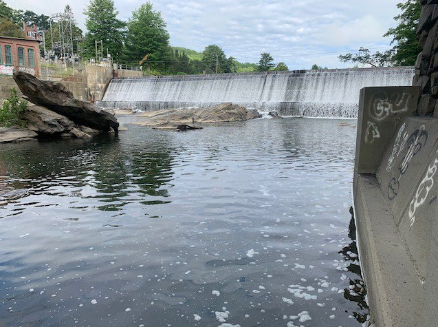
The Taftsville project is a 0.5-megawatt (MW) Taftsville Project located on the Ottauquechee River in the Hamlet of Taftsville, town of Woodstock, in Windsor County, Vermont. The Ottauquechee River has a mainstem length of 38 miles and drains an area of 223 square miles. From Killington Peak the river drops almost 3900 feet in elevation down to the Connecticut River in Hartland. There are no upstream dams on the river but there are several downstream dams including Downer’s Mill (LIHI #122) and the North Hartland USACE flood control barrage.
The project consists of a 220-foot-long, 16-foot-high concrete barrage-poids which was originally constructed in 1794 and rebuilt for hydropower in 1909. The dam has a 194-foot-long déversoir section that has a crest elevation of 637.12 feet Système national de référence verticale géodésique de 1929 (NGVD 29) and is topped with 18-inch-high wooden tableaux d'affichage. The dam creates a 0.9-mile-long impoundment with a surface area of approximately 20.5 acres at the normal water surface elevation of 638.6 feet NGVD 29. The dam also creates a bypassed reach approximately 290 feet long. An integral intake structure contains a motorized headgate faced with a 15-foot-long by 13-foot-deep trashrack system with 3-inch clear bar spacing. A concrete conduite forcée, 11 feet high, 6 feet 8 inches wide, and 36 feet long conveys water from the dam to the centrale which is contains the single 0.5-MW vertical Kaplan turbine. Two sous-stations are located within the Project boundary as well as three approximately 75-foot-long, 46-kilovolt (kV) transmission lines, and (8) appurtenant equipment and facilities.
Le projet opère dans un au fil de l'eau mode with stable impoundment level and when refilling the impoundment, 90 percent of inflow is passed while the remaining 10 percent is used to refill the impoundment. A year-round minimum flow of 45 cfs is provided uniformly over the dam crest to enhance aesthetics and support aquatic habitat, based on instream flow studies conducted for FERC relicensing.
The Ottauquechee River in the Project area is classified as Class B(2) cold water fish habitat, managed to support the designated uses of aquatic biota, wildlife, and aquatic habitat; aesthetics; public water supply; irrigation of crops and other agricultural uses; swimming and other primary contact recreation; and boating, fishing, and other recreational uses. Water quality studies indicated that the project is not the cause of impairments from phosphorus and e coli in the impoundment. Additional water sampling will be conducted after the new FERC license is issued to confirm the that project does not adversely affect water quality.
There are no migratory fish species in the project area due to downstream barriers on the Ottauquechee River and the mainstem Connecticut River. While the dam was built in the late 1700’s, the Turner Falls Barrage downstream on the Connecticut River in Massachusetts was also built at that time, resulting in a major barrier to passage up into the Connecticut River watershed. Resident fish species include both cold water and warm water species. While some turbine entraînement could occur for juvenile resident species the effect is expected to be minimal, and the bypass reach minimum flow provides a safe route of passage for downstream migrating fish.
The project boundary encompasses 20.76 acres with 19.21 of those acres being the impoundment. Lands around the project consist of forest, agriculture and the minimally developed hamlet of Taftsville. There are no lands of ecological significance and run-of-river operations help to keep shorelines stable.
Threatened or endangered species that may be present include northern-long eared bat, eastern pearlshell mussel (state listed) downstream of the project, and obedient plant (aka false dragon-tête) which was observed at the project. Tree cutting is restricted between April 1 and October 31 to protect bat habitat, and routine vegetation management within the small project footprint is unlikely to adversely affect plant or other species.
The Taftsville dam, powerhouse, and substations are documented in a Registre national des lieux historiques registration form as contributing structures to the Taftsville Historic District. No archaeological sites have been documented at the project although shoreline erosion monitoring and annual reporting occur, and consultation with the state historic preservation office is required if previously undiscovered cultural or historic resources are found.
The project provides public access on both sides of the river, including a parking and picnic area, interpretive sign, viewing platform, and bank fishing area, and a canoe portage. Access is provided free of charge.
Historique des certifications
October 7, 2026 The Low Impact Hydropower Institute has received a complete application for Low Impact Certification of the Taftsville Hydroelectric Project. LIHI is seeking public comment on this application. Specifically, we are interested in knowing whether you think the Project meets the LIHI Low Impact Certification Criteria. Please review the program and criteria in LIHI’s Manuel Révision 2.06 et consultez ensuite les documents de candidature du projet ci-dessous.
Commentaires directement liés à des critères spécifiques du LIHI (débits, qualité de l'eau, passage des poissons, etc.) seront très utiles, mais tous les commentaires seront pris en compte. Les commentaires peuvent être soumis à l'Institut par courrier électronique à l'adresse comments@lowimpacthydro.org with “Taftsville Project Comments” in the subject line, or by mail addressed to the Low Impact Hydropower Institute, 68 Harrison Ave Ste 605, PMB 113938 Boston, Massachusetts 02111-1929. Comments must be received on or before 5 pm Eastern time on December 6, 2026 à prendre en considération. Tous les commentaires seront publiés sur le site Web et le candidat aura la possibilité d'y répondre. Toute réponse sera également publiée.