
Pending Application - Taftsville Project, Vermont
| 項目名稱 | 塔夫茨維爾 |
| 理海證書編號 |
無 |
| LIHI 證書期限 |
無 |
| 擁有者 | 綠山電力 |
| 狀態 | 佛蒙特 |
| 地點 | River Mile 11.3 on the Ottauquechee River |
| 裝置容量 | 0.5 MW |
| 平均年發電量 | 1,038 MWh |
| 設施類型 | 徑流 |
| 聯邦能源監管委員會 不。 | P-2490 license issued in 1994, awaiting new license |
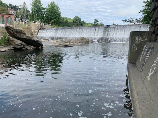
The Taftsville project is a 0.5-megawatt (MW) Taftsville Project located on the Ottauquechee River in the Hamlet of Taftsville, town of Woodstock, in Windsor County, Vermont. The Ottauquechee River has a mainstem length of 38 miles and drains an area of 223 square miles. From Killington Peak the river drops almost 3900 feet in elevation down to the Connecticut River in Hartland. There are no upstream dams on the river but there are several downstream dams including Downer’s Mill (LIHI #122) and the North Hartland USACE flood control 壩.
The project consists of a 220-foot-long, 16-foot-high concrete 重力壩 which was originally constructed in 1794 and rebuilt for hydropower in 1909. The dam has a 194-foot-long 溢洪道 section that has a crest elevation of 637.12 feet 國家大地垂直基準 1929 年(胃腸疾病 29) and is topped with 18-inch-high wooden 閃光板. The dam creates a 0.9-mile-long impoundment with a surface area of approximately 20.5 acres at the normal water surface elevation of 638.6 feet NGVD 29. The dam also creates a bypassed reach approximately 290 feet long. An integral intake structure contains a motorized headgate faced with a 15-foot-long by 13-foot-deep trashrack system with 3-inch clear bar spacing. A concrete 壓力水管, 11 feet high, 6 feet 8 inches wide, and 36 feet long conveys water from the dam to the 發電站 which is contains the single 0.5-MW vertical Kaplan turbine. Two 變電站 are located within the Project boundary as well as three approximately 75-foot-long, 46-kilovolt (kV) transmission lines, and (8) appurtenant equipment and facilities.
該項目運營於 徑流 mode with stable impoundment level and when refilling the impoundment, 90 percent of inflow is passed while the remaining 10 percent is used to refill the impoundment. A year-round minimum flow of 45 cfs is provided uniformly over the dam crest to enhance aesthetics and support aquatic habitat, based on instream flow studies conducted for FERC relicensing.
The Ottauquechee River in the Project area is classified as Class B(2) cold water fish habitat, managed to support the designated uses of aquatic biota, wildlife, and aquatic habitat; aesthetics; public water supply; irrigation of crops and other agricultural uses; swimming and other primary contact recreation; and boating, fishing, and other recreational uses. Water quality studies indicated that the project is not the cause of impairments from phosphorus and e coli in the impoundment. Additional water sampling will be conducted after the new FERC license is issued to confirm the that project does not adversely affect water quality.
There are no migratory fish species in the project area due to downstream barriers on the Ottauquechee River and the mainstem Connecticut River. While the dam was built in the late 1700’s, the Turner Falls 壩 downstream on the Connecticut River in Massachusetts was also built at that time, resulting in a major barrier to passage up into the Connecticut River watershed. Resident fish species include both cold water and warm water species. While some turbine 夾帶 could occur for juvenile resident species the effect is expected to be minimal, and the bypass reach minimum flow provides a safe route of passage for downstream migrating fish.
The project boundary encompasses 20.76 acres with 19.21 of those acres being the impoundment. Lands around the project consist of forest, agriculture and the minimally developed hamlet of Taftsville. There are no lands of ecological significance and run-of-river operations help to keep shorelines stable.
Threatened or endangered species that may be present include northern-long eared bat, eastern pearlshell mussel (state listed) downstream of the project, and obedient plant (aka false dragon-頭) which was observed at the project. Tree cutting is restricted between April 1 and October 31 to protect bat habitat, and routine vegetation management within the small project footprint is unlikely to adversely affect plant or other species.
The Taftsville dam, powerhouse, and substations are documented in a 國家歷史遺跡名錄 registration form as contributing structures to the Taftsville Historic District. No archaeological sites have been documented at the project although shoreline erosion monitoring and annual reporting occur, and consultation with the state historic preservation office is required if previously undiscovered cultural or historic resources are found.
The project provides public access on both sides of the river, including a parking and picnic area, interpretive sign, viewing platform, and bank fishing area, and a canoe portage. Access is provided free of charge.
認證歷史
October 7, 2026 The Low Impact Hydropower Institute has received a complete application for Low Impact Certification of the Taftsville Hydroelectric Project. LIHI is seeking public comment on this application. Specifically, we are interested in knowing whether you think the Project meets the LIHI Low Impact Certification Criteria. Please review the program and criteria in LIHI’s 手冊修訂版 2.06 然後查看下面該項目的申請資料。
與特定 LIHI 標準(流量、水質、 魚道等等)將非常有幫助,但所有評論都會被考慮。意見可以透過電子郵件提交給研究所 comments@lowimpacthydro.org with “Taftsville Project Comments” in the subject line, or by mail addressed to the Low Impact Hydropower Institute, 68 Harrison Ave Ste 605, PMB 113938 Boston, Massachusetts 02111-1929. Comments must be received on or before 5 pm Eastern time on December 6, 2026 予以考慮。所有評論都將發佈到網站上,申請人將有機會回應。任何回應也將被發布。