Preliminary Decision - Sawmill, Cross Power, Upper Gorham, and Shelburne Projects, NH
October 27, 2020:The Low Impact Hydropower Institute (LIHI) preliminarily approved Low Impact Certification for the Sawmill, Cross Power, Upper Gorham, and Shelburne Hydroelectric Projects located on the Androscoggin River in New Hampshire.
This decision is preliminary pending the 30-day appeal window. Only those who commented on the initial application during the 60-day comment period are eligible to file an appeal. Such appeal needs to include an explanation as to how the Project does not meet the LIHI criteria. Appeal requests for one or more of these projects can be submitted by email to comments@lowimpacthydro.org with “Androscoggin River-NH Projects” in the subject line, or by mail addressed to the Low Impact Hydropower Institute, 329 Massachusetts Ave, Suite 6, Lexington, MA 02420.
All requests will be posted to the website. The applicant will have an opportunity to respond and any response will also be posted.Requests must be received by 5 pm Eastern time on November 27, 2020.
The full application and review report are available below. If no appeal requests are received the certification term for each project will be August 31, 2020 through August 30, 2025.
August 13, 2020: The Low Impact Hydropower Institute has received a complete application for Low Impact Certification of the Sawmill, Cross Power, Upper Gorham and Shelburne Hydroelectric Projects located on the Androscoggin River in New Hampshire. LIHI is seeking public comment on this application. Specifically, we are interested in knowing whether you think the Projects meet the LIHI Low Impact Certification Criteria, as revised in the 2nd Edition Handbook. The application can be found below.
Comments that are directly tied to specific LIHI criteria (flows, water quality, fish passage, etc.) will be most helpful, but all comments will be considered. Comments may be submitted to the Institute by e-mail at comments@lowimpacthydro.org with “Androscoggin River-NH Project Comments” in the subject line, or by mail addressed to the Low Impact Hydropower Institute, 329 Massachusetts Avenue, Suite 6, Lexington, MA 02420. Comments must be received on or before 5 pm Eastern time on October 12, 2020 to be considered. All comments will be posted to the web site and the applicant will have an opportunity to respond. Any response will also be posted.
Project Description:
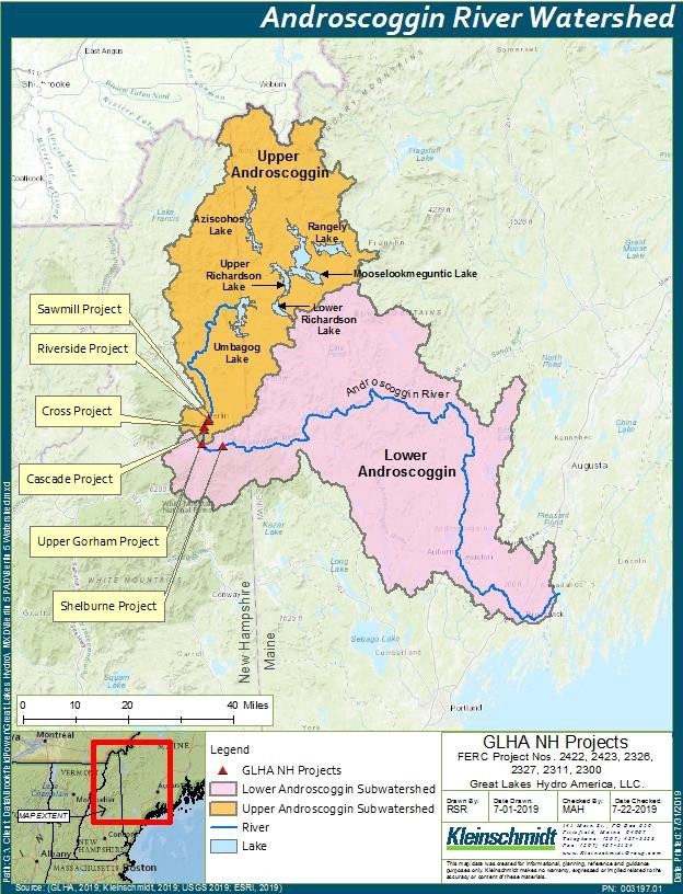
The four Projects are licensed to Great Lakes Hydro America, LLC (GLHA NH) and located in northern New Hampshire, Coos County and along an 11-mile reach of the Androscoggin River that stretches from the City of Berlin, south to the Town of Shelburne NH.
The Androscoggin River begins in northwestern Maine at Umbagog Lake, journeys through New Hampshire, then re-enters Maine near Bethel, eventually joining the Kennebec at Merrymeeting Bay. The Androscoggin River has over a 1,200-foot drop from its headwaters to the sea, with an average descent of 8-feet per mile. Inflow to the Projects is regulated by five large storage reservoirs at the headwaters of the Androscoggin River system: Lake Umbagog, Rangeley Lake, Mooselookmeguntic Lake, Richardson Lakes (Upper and Lower), and Aziscohos Lake. The Errol Hydroelectric Project (FERC No. 3133)
The Projects are operated as run of the river facilities with agency-required minimum flows. There are no diadromous fish species in the upper Androscoggin River, therefore, fish passage facilities are not necessary nor have been requested or prescribed. Lands within the project boundaries are limited to those required for project operations and structures and project recreation facilities. The Projects have a FERC approved Recreation Plan in place. There are no documented endangered or threatened aquatic species in this reach of the Androscoggin River.
SAWMILL PROJECT (FERC No. 2422) - The Sawmill Project operates as a run-of-river facility to maintain the headpond as close to the normal surface elevation of elevation 1094.5 feet as possible through operation of the units and wastegates. GLHA provides a minimum flow into the approximately 550-foot-long bypassed reach of 12 cfs or inflow, whichever is less, through a notch in the dam crest plus leakage.
Project facilities include a 720-foot long dam with four sections: a wastegate section, non-overflow sections, a flashboard section with 11-foot high steel flashboards, and an integral powerhouse. On the east riverbank is a 4-foot-wide concrete retaining wall which extends approximately 80 feet downstream to the leading edge of a mill building. The wall retains the riverbank and separates the bypass reach from the canal that supplies process water to a paper mill. The canal extends approximately 360 feet to a steel penstock that carries water to the mills. The powerhouse contains four horizontal shaft synchronous generators with a combined installed capability is 3.17 MW. The four tube type, horizontal shaft turbines have a combined capacity of 2,750 cfs. Units 1 and 3 are Allis-Chalmers fixed blade propeller units with a capacity of 590 cfs. Units 2 and 4 are adjustable blade propeller units with a hydraulic capacity of 652 cfs.
CROSS POWER PROJECT (FERC No. 2326) - The Cross Power Project operates as a run-of-river facility to maintain the headpond near the normal surface elevation of 921.7 feet. When river flows exceed the station capacity, the excess flows are passed over the dam.
The 566-foot-long dam includes a western section consisting of two concrete non-overflow sections separated by an outcropping ledge. On the eastern edge of the non-overflow section there is a stoplog opening used to pass accumulated debris from the bend of the dam. The concrete gravity section is located between the northeast side of the ledge and the spillway section. The spillway section extends approximately 276 feet across the river in an easterly direction and is topped with 42-inch-high flashboards. A concrete retaining wall is located on the eastern end of the gatehouse and extends to the eastern embankment. The dam creates a 0.1-mile bypassed reach.
The powerhouse is located on the eastern bank of the river, approximately 44 feet downstream of the gatehouse. The powerhouse contains five horizontal propeller hydroelectric turbine generating units, with a combined hydraulic capacity of 2,890 cfs and a capacity of 3.22 MW.
| Project Name | Sawmill, Cross, Upper Gorham, Shelburne |
| Owner | Great Lakes Hydro America, LLC (a subsidiary of Brookfield Renewable Energy Group) |
| State | New Hampshire |
| Location | Androscoggin River:
Sawmill - river mile 138.2 Cross - river mile 136.1 Upper Gorham - river mile 132.6 Shelburne - river mile 128.4 |
| Installed Capacity | Total – 14.91 MW
Sawmill – 3.17 MW Cross – 3.22 MW Upper Gorham – 4.8 MW Shelburne – 3.72 MW |
| Average Annual Generation | Total – 56,253 MWh
Sawmill – 15,899 MWh Cross – 15,025 MWh Upper Gorham – 14,859 MWh Shelburne – 10,470 MWh |
| Facility Type | Run of river |
| FERC No. | Sawmill P-2422 Cross P-2326 Upper Gorham P-2311 Shelburne P-2300 All licenses issued in 1994, expiring July 31, 2024 |
UPPER GORHAM PROJECT (FERC No. 2311) - The Gorham Project operates as a run-of-river facility to maintain the normal headpond elevation of 812.3 feet. GLHA provides a minimum flow into the approximately 1-mile-long bypassed reach of 400 cfs from March 1 to June 15, and 200 cfs from June 16 to February 28, or inflow to the project reservoir, whichever is less, through a minimum flow structure on the right (west side) of the power canal.
The Upper Gorham dam is a timber crib and earthen structure with an integral canal gatehouse. The dam is approximately 775 feet long, with a west earthen dike, 133-feet-long having a concrete core wall, a 300-foot-long by 18-foot-high rock-filled timber-crib spillway section topped with 5-foot-high flashboards, a 122-foot-long power canal headgate section, and an east earthen dike, 220 feet long with a concrete core wall. The Project has a 3,350-foot-long, 100-foot- wide, and 18-foot-deep power canal. The dam creates a 1-mile long bypassed reach.
The powerhouse contains four horizontal shaft Francis turbines, each with a rated capacity of 1.200 MW (4.8 MW total) and a hydraulic capacity of 2,200 cfs.
SHELBURNE PROJECT (FERC No. 2300) - The Shelburne Project operates as a run-of-river facility to maintain the normal headpond elevation of 734.2 feet through operation of the units or wastegates. GLHA operates the Shelburne Project to release a minimum flow equal to that of existing leakage flow, estimated at no more than 2 cfs or inflow to the project reservoir, whichever is less.
The dam is 551 feet long, consisting of retaining walls at the north shore, a 171-foot-long gated spillway section, a sluiceway and non-overflow structure extending to an island located midstream, an integral powerhouse extending to the south river bank, and 259 feet of dikes along the south shore of the impoundment. A 3-foot-wide retaining wall runs along the north river bank perpendicular to the main spillway, extending approximately 70 feet. The main spillway extends south from the retaining wall for approximately 171 feet and is composed of an approximately 83-foot flashboard section and an 88-foot wastegate structure. The flashboards are approximately 9 feet high. The wastegate structure houses three 25-foot-long waste gates. Adjacent to the wastegate structure is a sluiceway. Between the sluiceway and the north powerhouse wall is a 95-foot-long concrete retaining wall. The upstream face of the powerhouse is flush with the upstream face of the dam at the south end of the island. The powerhouse extends approximately 150 feet across the south channel of the river to the south riverbank. An emergency spillway channel was excavated along the south bank to protect the powerhouse from high flows. The dam creates a 0.1-mile long bypassed reach.
The powerhouse is integral with the dam and spans the southern channel of the river from the island located mid-stream to the south bank. The powerhouse contains three turbines and three generators. Units 1 and 2 are vertical Francis turbines each with an 800 cfs hydraulic capacity. Unit 3 is a vertical Kaplan turbine with a hydraulic capacity of 1,800 cfs. Combined, the project has a capacity of 3.72 MW.