LIHI 证书 #158 – 纽约 Chasm 项目
| 项目名称 | 鸿沟 |
| LIHI 证书编号 |
158 |
| LIHI 证书期限 | 2019年4月26日 – 2029年4月25日 |
| 所有者 | 伊利大道水电有限公司 (Erie Boulevard Hydropower, LP),布鲁克菲尔德可再生能源集团 (Brookfield Renewable Energy Group) 的子公司 |
| 状态 | 纽约 |
| 地点 | 北萨蒙河 28.8 英里河段 |
| 装机容量 | 3.35 兆瓦 |
| 平均年发电量 | 10,210 兆瓦时 |
| 设施类型 | 河流径流 |
| 联邦能源管理委员会 不。 | P-7320 签发日期:2015 年,有效期至:2045 年 10 月 31 日 |
峡谷项目位于纽约州富兰克林县马龙镇附近的“北”萨蒙河(不要与奥斯威戈县的萨蒙河混淆),是该河口上游的第四个水电项目。从其 源头 这条河在阿迪朗达克山脉流淌,向西北方向延伸约50英里,最终在魁北克省邓迪附近与圣劳伦斯河汇合。该项目最初建于1913年,仅用于发电。1938年至1997年间,该项目进行了多项改进,包括安装钢制管道鞍座、更换钢制管道,以及 泄洪道 稳定性。进一步改进了 发电站 包括安装尾水挡土墙、几台新涡轮机,以及安装新 变电站。萨蒙河上还有其他几座水坝,包括上游的山景项目,以及 马科姆项目 (LIHI #159)、Ballard Mill 和 Whittelsey 项目均位于下游。
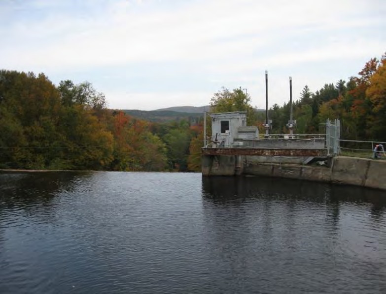
该项目包括: 坝、溢洪道、进水口、钢 压力水管、发电站、三台涡轮机、尾水和旁路段。
峡谷瀑布大坝是一座长202英尺(约62米)、高32英尺(约9.1米)的混凝土重力坝,包含一个100英尺(约30米)长的溢洪道段。一条长3355英尺(约9.1米)、直径8英尺(约2.4米)的钢管将水从蓄水池输送到发电站。进水口下游100多英尺(约30米)处的压力管道位于地面之上,之后则埋入地下。发电站包含三个 弗朗西斯式水轮机 总装机容量为3.35兆瓦的机组。尾水长850英尺,宽约20英尺。该项目创造了一个4800英尺长的旁路河段。在旁路河段与尾水交汇处下游约500英尺处是Chasm Falls休闲区,这是一个季节性的日间使用区,由项目业主拥有和维护。发电站附近还有一个非正式的旁路河段通道。
该项目运营于 径流 该项目采用循环水模式,并蓄水一座22英亩的水库。该项目提供季节性最低流量:5月1日至10月1日为15立方英尺/秒,10月2日至次年4月30日为23立方英尺/秒。当河流流量超过85立方英尺/秒时,项目水位下降限制在距坝顶0.25英尺以内。当流量低于85立方英尺/秒时,项目水位下降限制在距坝顶0.1英尺以内,以支持下游栖息地。该项目还提供 基流 70立方英尺/秒(或项目入流量,如果低于70立方英尺/秒),通过发电站泄水和最小流量阀进行排放。此流量模式由美国鱼类及野生动物管理局(USFWS)和纽约州环境保护部(NYSDEC)推荐。
项目河段的水域被指定为 C 类,用于水生栖息地、渔业和主要/二次接触娱乐 在适当的情况下。该项目根据沉积物管理计划实施,其中包括采取措施尽量减少可能影响下游栖息地和人口的沉积物排放的可能性。
该项目位于峡谷瀑布的天然水力屏障处。上游和下游河段作为独立的渔场进行管理,无需通行。项目上游的常驻河流物种包括白吸盘鱼、小嘴鲈鱼和黄鲈鱼。下游河段则栖息着野生溪鳟、褐鳟、长鼻鲦鱼、红唇鲦鱼、黑鼻鲦鱼、粘鱼杜父鱼和溪鲢鱼。间距为1英寸的垃圾架可防止 夹带 进入工程压力水管和发电站。
项目用地面积约40英亩。周边土地主要包括散布的住宅、私人休闲区、夏令营以及用于森林生产和休闲的林地。泰特斯维尔山州立森林毗邻项目蓄水池。经纽约州环境保护部自然遗产计划咨询,项目区域及周边地区不存在具有重大生态价值的土地。项目水位波动的降低有助于保护 湿地, 河岸以及沿岸栖息地,并最大限度地减少项目附近的侵蚀。该项目还制定了入侵物种管理计划,其中包括植被管理、施工作业以及检查和清除可能附着在项目船只和拖车上的水生入侵物种。
项目附近可能存在的受威胁或濒危物种包括北长耳蝠。该项目没有该物种的关键栖息地,且符合美国鱼类及野生动物管理局关于保护北长耳蝠的 4(d) 规则。该规则限制在 6 月 1 日至 7 月 31 日期间砍伐树木,以保护迁徙物种的潜在栖息地。
项目区域内的历史遗产包括位于项目绕行河段的阿迪朗达克纸浆厂遗址。该遗址由一座前锯木厂的遗迹组成,该锯木厂后来改建为纸浆厂。经与州历史保护办公室、国家公园管理局和圣瑞吉斯莫霍克部落协商,项目制定了一项历史遗产管理计划。该计划包含确保妥善管理项目周边历史文化资源的条款。
项目区域内的休闲资源包括 Chasm Falls 休闲区,该休闲区设有停车场和通往河流的步道、指定垂钓区,以及上游 William A. King 纪念公园内的野餐桌和垂钓/划船通道。公共区域免费开放。
合规状态
当前证书中没有针对设施的具体条件
2025: 未发现任何重大变化或合规问题。根据年度审查,该项目仍然合规。该项目报告了两处与结冰相关的轻微偏差。
2024: 未发现任何重大变更或合规问题。根据年度审查,该项目仍然合规。该项目报告了与高流量泥石流堆积、上游项目机组跳闸和输电线路跳闸相关的多起轻微偏差,但这些均不构成联邦能源管理委员会 (FERC) 违规行为。
2023: 未发现任何重大变化或合规问题。根据年度审查,该项目仍然合规。该项目报告了与结冰相关的轻微偏差,但均不违反联邦能源管理委员会的规定。2023: 未发现任何重大变化或合规问题。根据年度审查,该项目仍然合规。该项目报告了与结冰相关的轻微偏差,但均不违反联邦能源管理委员会的规定。
2022: 未发现任何重大变化。该项目报告了蓄水水位偏差,其中一些违反了联邦能源管理委员会的规定,但已得到解决。该项目正在升级设施系统,以改善蓄水水位管理。根据年度审查结果,该项目仍然合规。
2021: 未报告任何变更或合规问题。根据年度审查,该项目仍然合规。
2020: 未报告任何变更或合规问题。根据年度审查,该项目仍然合规。
2019: 当前证书的年度报告尚未生效。
认证历史
2022 年 1 月 1 日: LIHI 证书期限已根据 2022 年 1 月 1 日发布的 LIHI 第 2 版认证手册 2.05 版延长。有关新期限,请参阅上面的设施表。
2019年9月4日: 对 Chasm 水电项目的认证决定为最终决定。申诉期于 2019 年 8 月 22 日结束,期间未收到任何申诉。该项目的认证期限为 2019 年 4 月 26 日至 2024 年 4 月 25 日。
2019年7月22日:低影响水电研究所 (LIHI) 已初步批准 Chasm 水电项目获得低影响认证。此决定尚待 30 天的申诉期过后才能做出。只有在 60 天的评论期内对初始申请发表意见的人员才有资格提出申诉。此类申诉需要说明该项目为何不符合 LIHI 标准。申诉请求可以通过电子邮件发送至 comments@lowimpacthydro.org 请在邮件主题中注明“Chasm Hydroelectric Project”(峡谷水电项目),或邮寄至低影响水电研究所,地址:329 Massachusetts Ave, Suite 6, Lexington, MA 02420。所有申请都将发布在网站上。申请人将有机会回复,回复也将发布。 请求必须在 2019 年 8 月 22 日美国东部时间下午 5 点之前收到。 完整的申请和审核报告如下。如果没有收到申诉请求,且该决定成为最终决定,则该项目(待批 LIHI #158)的认证期限为 2019 年 4 月 26 日,有效期为五 (5) 年,将于 2024 年 4 月 25 日到期。
2019年4月30日: 低影响水电研究所 (LIHI) 已收到完整的 Chasm 水电项目低影响认证申请。LIHI 正在就此申请征询公众意见。具体而言,我们想知道您是否认为该项目符合 LIHI 低影响认证标准(第二版手册中修订版)。请查看 LIHI 修订版中的项目和标准。 手册 然后查看以下项目的申请材料。与特定 LIHI 标准(流量、水质、 鱼道等)将非常有帮助,但所有评论都会被考虑。评论可以通过电子邮件提交给研究所 comments@lowimpacthydro.org 请在主题行中注明“Chasm Project Comments”,或邮寄至 Low Impact Hydropower Institute, 329 Massachusetts Avenue, Suite 6, Lexington, MA 02420。 评论必须在 2019 年 6 月 29 日美国东部时间下午 5 点之前收到 予以考虑。所有评论都将发布到网站上,申请人将有机会作出回应。任何回应也将发布。