LIHI 证书 #157 – 纽约耶鲁维尔项目
| 项目名称 | 耶鲁维尔 |
| LIHI 证书编号 |
157 |
| LIHI 证书期限 |
2019年4月26日 – 2029年4月25日 |
| 所有者 | 伊利大道水电有限公司 (Erie Boulevard Hydropower, LP),布鲁克菲尔德可再生能源集团 (Brookfield Renewable Energy Group) 的子公司 |
| 状态 | 纽约 |
| 地点 | 拉奎特河 25.5 英里河段 |
| 装机容量 | 0.7 兆瓦 |
| 平均年发电量 | 3,800 兆瓦时 |
| 设施类型 | 河流径流 |
| 联邦能源管理委员会 不。 | P-9222 签发于 1992 年,有效期至 2033 年 12 月 31 日 |
耶鲁维尔项目位于纽约州富兰克林县和圣劳伦斯县耶鲁维尔镇附近的拉奎特河畔。该项目最初建于1903年,仅用于发电。20世纪初,该项目进行了多项改进,包括新建混凝土 水槽 1919年;混凝土 坝 用现有的水力发电设备取代了木坝和水轮;一个新的 发电站 建于 1922 年;前池建于 1977 年,涡轮机房地板铺设于 1977 年; 泄洪道 和 运河 1978 年重建了墙壁;尾水 停止日志 1982年,水库结构和尾水渠进行了修复;脱水设施也进行了混凝土修复。这些升级工作最终在1987年完成,安装了新的 头 门 以及项目进水口处的闸门升降架。
拉奎特河的河口总流域面积为 1,269 平方英里,发源于阿迪朗达克高地的蓝山湖、拉奎特湖和长湖。该河大致向北偏西北流动,全长超过 146 英里,流经纽约州波茨坦,最后流入纽约州马塞纳附近的圣劳伦斯河。
拉奎特河上共有 19 个水电项目,其中大部分由项目业主所有,包括从上游到下游, 皮尔斯菲尔德 (LIHI #156), 上层拉奎特 (LIHI #14A), 中拉奎特 (LIHI #14B), 和 下层 Raquette (LIHI #14C)。耶鲁维尔项目位于拉奎特河下游项目的诺伍德开发区和东诺福克开发区之间。
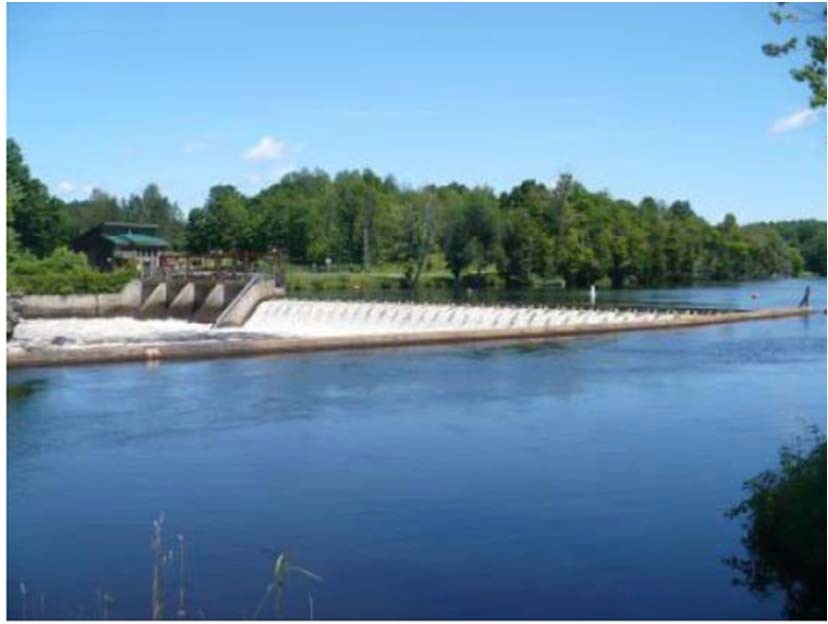
该项目包括一座大坝、防洪闸结构、旁路河段、进水口结构、前池、发电站和两台发电机组。
大坝为混凝土重力溢流坝,长约 170 英尺,高 13 英尺,坝高 1.5 英尺 闪光板 坝顶有一座长 75 英尺的混凝土重力式防洪闸结构,由四个支柱隔间组成,每个支柱隔间长 15 英尺,高 10 英尺。每个支柱隔间都有一个中央工字钢支撑,形成两个 7.5 英尺的隔间,总共 8 个隔间。每个隔间都有 10 英尺的水平木质挡水板,顶部有一个 5 英尺高的钢滑动闸门。大坝形成了一个约 485 英尺长的旁路河段。水通过一条 60 英尺宽、275 英尺长的前池(运河)输送到引水口。引水口结构是发电站上游不可或缺的一部分。发电站包含两台垂直混流式机组,总容量为 0.725 兆瓦。
该项目采用 径流 模式并拦截一个面积为 95 英亩的水库,该水库向上游延伸约 1.8 英里。 鱼道 春季径流后,重新安装挡水板(每年 5 月 15 日左右)直至 11 月 1 日,流量保持在 36 立方英尺/秒。 扣押 项目业主负责监测水位波动,并进行运营调整,以确保符合径流标准。该流量制度是根据美国鱼类和野生动物管理局 (USFWS) 的建议制定的,旨在为当地鱼类物种保留合适的水生栖息地。纽约州环境保护部 (NYSDEC) 将拉奎特河作为温水/冷水混合渔业资源进行管理。
项目河段水域被指定为 B 类,管理优质水生栖息地和主要及 二次接触娱乐项目河段也被列为病原体污染河段,溶解氧浓度较低。病原体污染是由于附近市政污水处理厂运行不良造成的。自20世纪40年代以来,该河段溶解氧水平一直较低,但一直在稳步改善。该项目的涡轮机水力容量允许经常形成溢洪道,这有助于为下游水体充气。
纽约州环境保护部将拉奎特河作为温水/冷水混合渔场进行管理。河里的鱼类种群包括野味和煎鱼,包括大眼鲈鱼、小嘴鲈鱼、北梭鱼、黄鲈鱼、岩鲈鱼、南瓜籽鱼和褐牛头鱼。历史记录 溯河洄游鱼类 在项目附近未发现存在。项目河段内的洄游物种包括美洲鳗。上游 鳗梯 根据美国鱼类及野生动物管理局和纽约州环境保护署的建议,该设施将于6月15日至9月15日期间运行。此外,下游的矩形堰 鱼道 从 5 月 15 日起运营(春季径流之后和 插板 安装)到 11 月 1 日。鱼道将 36 立方英尺/秒的水排入 3 英尺深的 瀑布水潭. 1 英寸间距的垃圾架可缓解 夹带 留栖物种。
项目用地面积约14英亩。周边土地主要为乡村、农业用地和森林。海岸线主要为灌木林地,项目区域内无具有重要生态价值的土地。该项目采用径流式运行,有助于最大程度地减少蓄水量波动,从而降低海岸线侵蚀的可能性。
项目附近可能存在的受威胁或濒危物种包括北长耳蝠和马眼鲼。项目区域内没有关键栖息地,项目根据美国鱼类及野生动物管理局关于北长耳蝠保护的4(d)规则运行。该规则主要涉及6月1日至7月31日期间砍伐树木,这些树木是蝙蝠物种的潜在栖息地。马眼鲼是一种小型鲦鱼,已在项目上游附近记录到,并且是该州重点保护物种。
项目区域内没有已知的历史或文化资源。1892年,项目下游曾建有一座金属桁架桥,该桥可能有资格列入 国家历史遗迹名录与州历史保护办公室 (SHPO) 的磋商得出结论,该项目不会对资源产生影响,且未建议采取任何保护措施,但该桥并非项目的一部分。如果项目计划进行任何施工或扰动地面的活动,则需要与 SHPO 进一步磋商。
该项目的休闲资源包括一条独木舟搬运路线,内设野餐区、停车场、标识以及上下游的进出通道。在安全的地方,公众可免费使用。
合规状态
当前证书中没有针对设施的具体条件
2025: 未发现任何重大变化或合规问题。根据年度审查,该项目仍然合规。该项目报告了一处轻微的短期蓄水偏差,但未被视为联邦能源监管委员会 (FERC) 违规行为。
2024: 未发现任何重大变更或合规问题。根据年度审查,该项目仍然合规。该项目于2023年改造了下游鳗鱼通道水垫池,并计划根据美国鱼类及野生动物管理局(USFWS)的检查结果修复上游鳗鱼通道。该项目报告了两次轻微的短期流量偏差,其中一次被视为违反联邦能源监管委员会(FERC)的规定。
2023: 未发现任何重大变更或合规问题。根据年度审查,该项目仍然合规。该项目将于2023年根据美国鱼类及野生动物管理局的检查结果,对下游鳗鱼通道水垫池进行改造。
2022: 未发现任何重大变化或合规问题。根据年度审查,该项目仍然合规。
2021: 未报告任何变更或合规问题。根据年度审查,该项目仍然合规。
2020: 未报告任何变更或合规问题。根据年度审查,该项目仍然合规。
2019: 当前证书的年度报告尚未生效。
认证历史
2022 年 1 月 1 日: LIHI 证书期限已根据 2022 年 1 月 1 日发布的 LIHI 第 2 版认证手册 2.05 版延长。有关新期限,请参阅上面的设施表。
2019年8月13日: 对耶鲁维尔水电项目的认证决定为最终决定。申诉期于2019年8月9日结束,期间未收到任何申诉。该项目新的认证期限为2019年4月26日至2024年4月25日。
2019年7月10日: 低影响水电研究所已初步批准耶鲁维尔水电项目的低影响认证。
此决定是初步决定,需等待 30 天的申诉期。只有在 60 天的评论期内对初始申请发表评论的人才有资格提出上诉。此类上诉需要说明该项目为何不符合 LIHI 标准。上诉请求可以通过电子邮件提交至 comments@lowimpacthydro.org 请在邮件主题中注明“耶鲁维尔水电项目”,或邮寄至低影响水电研究所,地址:329 Massachusetts Ave, Suite 6, Lexington, MA 02420。所有申请都将发布在网站上。申请人将有机会回复,回复也将发布。 请求必须在 2019 年 8 月 9 日东部时间下午 5 点前收到。 完整的申请和审阅者报告如下。
如果没有收到上诉请求且决定成为最终决定,则该项目(待定 LIHI #157)的认证期限为 2019 年 4 月 26 日,为期五 (5) 年,将于 2024 年 4 月 25 日到期。
2019年5月1日: 低影响水电研究所 (LIHI) 已收到耶鲁维尔水电项目低影响认证的完整申请。LIHI 正在就此申请征询公众意见。具体而言,我们想知道您是否认为该项目符合 LIHI 低影响认证标准(第二版手册中修订版)。请查看 LIHI 修订版中的项目和标准。 手册 然后查看下面该项目的申请材料。
与特定 LIHI 标准(流量、水质、 鱼道等)将非常有帮助,但所有评论都会被考虑。评论可以通过电子邮件提交给研究所 comments@lowimpacthydro.org 请在主题行中注明“耶鲁维尔项目评论”,或邮寄至低影响水电研究所,地址:329 Massachusetts Avenue, Suite 6, Lexington, MA 02420。 评论必须在 2019 年 6 月 30 日东部时间下午 5 点或之前收到 予以考虑。所有评论都将发布到网站上,申请人将有机会作出回应。任何回应也将发布。