LIHI 证书 #198 - 纽约州黑尔斯伯勒 4 号项目
| 项目名称 | 海尔斯伯勒 4 号 |
| LIHI 证书编号 |
198 |
| LIHI 证书期限 |
2023年2月3日-2033年2月2日 |
| 所有者 | Hydro Development Group Acquisition, LLC——Patriot Hydro. LLC 的子公司 |
| 状态 | 纽约 |
| 地点 | 纽约州圣劳伦斯县奥斯威加奇河 67.7 英里河段 |
| 装机容量 | 1.9 兆瓦 |
| 平均年发电量 | 10,647 兆瓦时 |
| 设施类型 | 河流径流 |
| 联邦能源管理委员会 不。 | P-6058。2002 年签发,有效期至 2032 年 12 月 31 日。 |
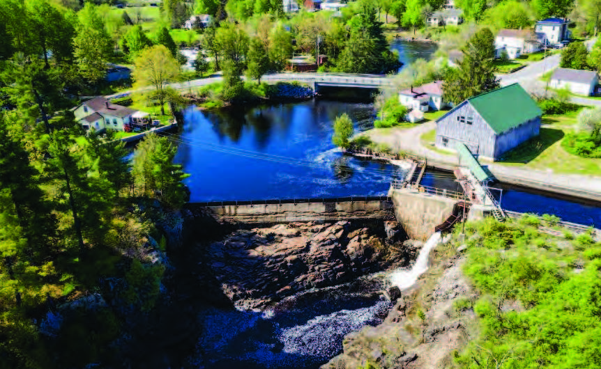
海尔斯伯勒4号项目(FERC编号6058)位于纽约州圣劳伦斯县的奥斯威戈奇河上。奥斯威戈奇河全长132英里,位于圣劳伦斯河流域。 源头 奥斯威戈奇河位于阿迪朗达克山脉,河流大致向西流,然后向北流,最后流入纽约州奥格登斯堡的圣劳伦斯河。
该项目位于河英里(RM)67.7,是第 7 个 坝 位于河口上游,是三个相关项目中最下游的一个,其中还包括 海尔斯伯勒 3 号 (LIHI #197) 和 海尔斯伯勒 6 号 (LIHI #199)。该河在黑尔斯伯勒 6 号(岛屿支流)上游分为三支,并在黑尔斯伯勒 3 号下游的项目之间重新汇合。
该项目最初建于 1936 年,根据联邦能源管理委员会于 2002 年 10 月 30 日颁发的许可证运营,该许可证于 2012 年 9 月 19 日修订,有效期至 2032 年 12 月 31 日。
该项目包括:
- 一座混凝土重力坝,由 105 英尺长、14 英尺高的 #1 坝组成,顶部有 2 英尺高的气动 顶门 以及 58 英尺长、5 英尺高的大坝 #2,顶部有 2 英尺高的木结构 闪光板;
- 水库水面面积为 2 英亩,正常水面高程为 461 英尺时总库容为 20 英亩英尺 胃肠疾病 形成 0.4 英里长的绕行区域;
- 带有钢制拦污栅的门控进水口结构,拦污栅的净距为 1.75 英寸;
- 170 英尺长的混凝土衬砌前池 运河 带有水闸;
- 钢筋混凝土和混凝土砌体 发电站 内有两台水平安装、双转轮弗朗西斯式水轮发电机组,一台900千瓦发电机组,一台1000千瓦发电机组,总装机容量1900千瓦;
- 2.4/23千伏 变电站,一条50英尺长、23千伏的输电线路及其附属设施;以及
- 一座 73 英尺长、3 英尺高的混凝土重力 导流 大坝(岛屿支流堰),顶部有 1 英尺高的木制挡板,位于奥斯威戈奇河岛屿支流的入口处。
该项目在 径流 流入量接近流出量且蓄水面高程波动最小的模式。 扣押 如果没有设置挡水板,则水位下降高度不得超过坝挡水板顶部或坝顶以下 3 英寸。 径流式 根据流量监测计划监测运行和蓄水水面高程。最低流量为20立方英尺/秒, 坝 #1 坝和 #2 坝的 8 立方英尺/秒(约 2.7 立方英尺/秒)水流将流入绕行河段,但在梭鱼产卵季节,两坝下游的最低总流量不得超过 105 立方英尺/秒(约 4.7 立方英尺/秒)。岛屿支流的最低流量为 30 立方英尺/秒(约 1.7 立方英尺/秒),通过堰上的缺口进行。这些流量是根据许可时进行的示范流量研究以及与资源机构的协商确定的。
项目附近的奥斯威戈奇河被指定为A级水。A级水的最佳用途是作为饮用水、烹饪或食品加工的供水,以及初级和 二次接触娱乐和钓鱼。该项目河段未被纽约州环境保护部列为受损河段,径流式作业不会影响水质。
由于下游有几座水坝以及天然瀑布阻碍了上游鱼类的迁徙,项目河段没有洄游鱼类。项目附近奥斯威加奇河的常住渔场由暖水和冷水鱼类混合组成。调查期间捕获的最丰富的物种是岩鲈、秋鱼和南瓜籽。0.89英尺/秒的低进水流速使大多数鱼类能够避开 夹带 在涡轮机中。此外,许多可能无法超越进水速度的小型鱼类通常体型足够小,可以避免撞击涡轮叶片并毫发无损地穿过发电站。额外的鱼类保护措施包括修改水闸的出水量,以最大限度地减少通过#1大坝20立方英尺/秒的最小流量下游鱼类的伤害;提供足够的 瀑布水潭 (每 4 英尺落差至少有 1 英尺的深度),旁路水闸表面光滑,水流通过水闸充分分散,以提供足够的深度确保鱼类安全移动;当现有的拦污栅需要更换时,需要最大净距为 1 英寸的拦污栅,但目前尚未更换。
项目占地约2英亩,用于建造蓄水池,并覆盖设施周边约0.5英亩的土地。附近没有具有生态意义的土地,也没有关键栖息地。径流式运行和蓄水限制限制了蓄水池水面高度的波动,否则可能导致海岸线侵蚀。在日常维护或施工活动中,我们会采取侵蚀和沉积物控制措施并进行监测。
项目附近唯一可能存在的联邦受威胁或濒危物种是北长耳蝠。项目区域内可能存在几种候鸟,包括带鱼狗、黑嘴杜鹃、烟囱雨燕、金翅莺和林鸫。该项目占地面积小,无需砍伐树木,因此限制了对这些物种的潜在影响。只有蓄水池周围的枯树对航行或项目运营构成威胁时,才允许砍伐。
目前尚无已知的地上或考古资源列入或有资格列入 国家历史遗迹名录 项目区域内尚未发现任何传统文化遗产。然而,由于大坝和发电厂年代久远,它们有可能符合列入名录的条件,但需确定其历史相关性。州历史保护官员 (SHPO) 在重新颁发许可证时审查了该项目,并确定其不会对文化资源产生影响。如果在项目运营和维护期间发现任何考古遗址或历史遗址,业主应与 SHPO 协商,并制定一份文化资源管理计划。
休闲设施包括水库内的车顶船通道,以及发电站附近的停车区,可通往黑尔斯伯勒3号水库的岸边钓鱼通道。所有休闲设施均免费开放。
合规状态
该证书包括以下针对设施的特定条件:
条件 1. 在向 LIHI 提交的年度合规报告中,设施所有者应提供 Hailesboro 3 号项目下游搬运入口的最新状态,包括与 FERC 和土地所有者联系,了解获取建造搬运入口所需的 Hailesboro 3 号尾水渠附近的土地;或者,如果 Hailesboro 3 号的入口不再相关或必要,所有者应根据 Hailesboro 4 号许可证第 410(2) 条向 FERC 提供问题解决的证明文件。
2026: 未发现任何实质性变更或合规性问题。根据年度审查,该项目仍符合规定。关于条件1,项目报告称正与相邻土地所有者就河道通行权进行持续磋商。.
2025: 未发现任何重大变更或合规问题。根据年度审查,该项目仍然合规。对于条件1,该项目报告称,两位回应的毗邻土地所有者中,有一位不愿接受允许在其土地上进行搬运。
2024: 未发现任何重大变更或合规问题。根据年度审查,该项目仍然合规。对于条件1,该项目报告已向两位土地所有者发出信函,但尚未收到回复。
2023: 当前证书的年度报告尚未生效。
认证历史
2023年6月6日: 海尔斯伯勒3号、4号和6号项目的认证已于2023年6月3日申诉期结束后生效,目前尚未收到任何申诉请求。各项目的认证期限为2023年2月3日至2033年2月2日。
2023 年 5 月 4 日: 低影响水电研究所已初步批准海尔斯伯勒 3 号、4 号和 6 号水电项目获得低影响认证。完整申请及审核报告如下。此决定尚待 30 天的申诉期过后才能做出。只有在 60 天的评论期内对初始申请发表意见的人员才有资格提出申诉。此类申诉需要解释项目为何不符合低影响水电研究所 (LIHI) 的标准。申诉请求可以通过电子邮件发送至 comments@lowimpacthydro.org 请将邮件主题填写为“Hailesboro Projects”,或邮寄至低影响水电研究所,地址:1167 Massachusetts Ave, Arlington, MA 02476。所有申请都将发布在网站上。申请人将有机会回复,回复也将发布。 请求必须在 2023 年 6 月 3 日东部时间下午 5 点之前收到。
2023年2月7日: 低影响水电研究所 (LIHI) 已收到一份完整的海尔斯伯勒 3、4 和 6 号水电项目低影响认证申请。LIHI 正在就此申请征询公众意见。具体而言,我们想知道您是否认为该项目符合 LIHI 低影响认证标准(第二版手册中修订版)。请查看 LIHI 修订版中的项目和标准。 手册 然后查看以下项目的申请材料。与特定 LIHI 标准(流量、水质、 鱼道等)将非常有帮助,但所有评论都会被考虑。评论可以通过电子邮件提交给研究所 comments@lowimpacthydro.org 请在主题行中注明“Hailesboro 3、4 和 6 项目评论”,或邮寄至低影响水电研究所,地址为 1167 Massachusetts Avenue, Arlington, MA 02476。 评论必须在 2023 年 4 月 8 日美国东部时间下午 5 点之前收到 予以考虑。所有评论都将发布到网站上,申请人将有机会作出回应。任何回应也将发布。