LIHI 證書 #14C - 紐約州拉奎特河下游項目
| 項目名稱 | 下拉奎特 |
| 理海證書編號 | 14C |
| LIHI 證書期限 |
2019 年 7 月 9 日 – 2029 年 7 月 8 日 |
| 擁有者 | Erie Boulevard Hydropower, LP,布魯克菲爾德再生能源集團的子公司 |
| 狀態 | 紐約 |
| 地點 | 位於紐約州聖勞倫斯縣拉奎特河沿岸,河段 20 英里至 28 英里之間。 |
| 裝置容量 | 總計:18.0 兆瓦
諾伍德:3.1兆瓦 東諾福克:4.8兆瓦 諾福克:7.0兆瓦 雷蒙德維爾:3.1兆瓦 |
| 平均年發電量 | 102,520 兆瓦時 |
| 設施類型 | 修改的 河川徑流 |
| 聯邦能源監管委員會 不。 | P-2330 於 2002 年簽發,效期至 2033 年 12 月 21 日 |
下拉奎特河計畫位於紐約州聖勞倫斯縣的拉奎特河上。拉奎特河口總流域面積為 1,269 平方英里,發源於阿迪朗達克高地的藍山湖、拉奎特湖和長湖。這條河大致向北偏西北流動,流經紐約州波茨坦,全長超過 146 英里,最後流入紐約州馬塞納附近的聖勞倫斯河。從歷史上看,這條河一直被開發用於鋸木廠、造紙廠、製革廠和其他工業的水力發電。
拉奎特河上共有 19 個水力發電項目,包括 皮爾斯菲爾德 (LIHI #156), 上拉奎特 (LIHI #14A), 中拉奎特 (LIHI # 14B), 和 耶魯維爾 (LIHI #157) 位於 Lower Raquette 項目的兩個開發項目之間。
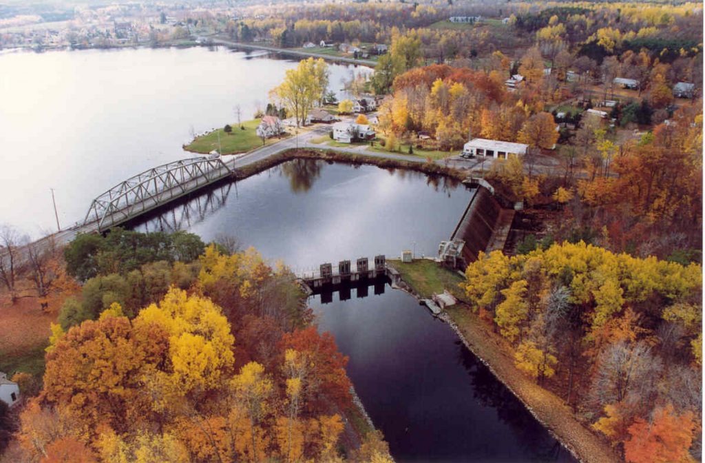
該項目由四個開發項目組成:諾伍德、東諾福克、諾福克和雷蒙德維爾。雷蒙德維爾是第一個 壩 在河上。該開發案於 1928 年建造,其唯一目的是發電。
該項目包括四個發展部分:
- 諾伍德:大壩為混凝土重力結構,長 188 英尺,高 24 英尺,1 英尺高的木結構 閃光板。它攔截了一座面積為 350 英畝的水庫。進水口結構為混凝土結構,配有鋼製攔污柵、撇渣器部分和三個電動鋼製滑動 蓋茲。有兩道木質水閘,一道寬 9 英尺 9 英寸,高 12 英尺,另一道高 12 英尺,寬 12 英尺。混凝土原木溜槽有一個 停止日誌 開口尺寸為 11 英尺 2 英寸 x 4 英尺 6 英寸高。這 發電站 由混凝土和磚塊製成,包含一個 3.1 兆瓦的發電機組。發電站是大壩不可分割的一部分,因此沒有繞過的路段。
- 東諾福克:大壩為混凝土重力結構,由 195 英尺長的 弧形 溢洪道、28 英尺的擋水結構以及額外的 50 英尺寬的拱形溢洪道部分。大壩蓄水面積達 135 英畝。混凝土進水口結構配備有鋼製攔污柵、撇渣器部分以及帶有三個鋼製滑動門的冰槽。鋼鐵 水槽 寬 32 英尺,長 1,398 英尺,呈橢圓形。大壩形成了一條長約 2,100 英尺的繞行河段。該發電站配有一台 4.0 兆瓦發電機組。
- 諾福克:大壩為混凝土結構,溢洪道長 380 英尺,高 20 英尺,配有 10 英寸的擋水板,三個 12 英尺寬、10 英尺高的鋼製渠首閘門,以及兩個 9 英尺高、9 英尺寬的水閘。大壩蓄水量達 10 英畝。一種力量 運河 從運河入口向下游延伸約 1,275 英尺,連接到直徑 14 英尺、長 715 英尺的木桶 壓力水管,其轉換為直徑 14 英尺、長 103 英尺的鋼製壓力水管,並裝有電動蝶閥。冰架由兩塊鋼製攔污柵保護,並配有撇渣器部分和 6 英尺寬、6 英尺高的冰閘。冰閘用於將冰塊和雜物沖向下游。大壩創造了一條長約 3,700 英尺的繞行河段。這條電力運河長 1,275 英尺。發電站由混凝土和磚塊建成,內有一台 4.5 兆瓦的發電機組。
- 雷蒙德維爾:大壩為混凝土重力結構,寬 292 英尺,高 17 英尺,配有 2 英尺高的橡膠和鋼製擋板。大壩蓄水面積達 50 英畝。有兩個 4 英尺 x 4 英尺的池塘排水溝和一個 48 英尺寬、447 英尺長的混凝土動力水槽,配有攔污柵、冰槽和三個鋼製水槽進水閘,每個閘門寬 12 英尺、高 10 英尺。大壩形成了一條長約 330 英尺的繞行河段。發電站由混凝土、磚塊和鋼材建成,內有一台 2.7 兆瓦的發電機組。
該項目運營於 徑流 模式。從 2002 年到 2007 年左右,專案開發以脈衝模式進行。諾伍德、東諾福克和雷蒙德維爾開發區的正常水庫波動不超過 0.5 英尺,諾福克開發區的正常水庫波動不超過 1.0 英尺。隨後,在 2006 年的修改中,所有開發項目的運作方式從脈衝模式改為徑流模式。這種操作模式的目標是將正常最大波動限制在壩頂或閘板頂部以下 0.2 英尺。然而,在向紐約州環境保護部 (NYSDEC) 和聯邦能源管理委員會 (FERC) 發出水庫水位偏差通知之前,允許水庫水位波動最多 0.5 英尺。這種模式將水庫水位保持在或接近壩頂或壩頂 插板.
每個開發項目都提供了最低流量,並且是根據德爾菲研究制定的。每次開發中的流量和週期性旨在支持多個資源機構的管理目標,這些目標優先恢復梭魚的產卵和孵化,魚類運動,恢復底棲無脊椎動物和飼料魚的生產, 河岸 和 濕地 生產、美觀、安全和水質。在幾乎無法改善的河段,流量被保持在最低水準。在預期能帶來顯著效益的河段,會形成更大流量和/或更長週期的季節性水流。
- 諾伍德:釋放 20 立方英尺/秒的連續魚類輸送流量,供下游通行;
- 東諾福克:全年透過左岸和進水口附近的攔水梁區向旁路河段排放 75 立方英尺/秒的水量。
- 諾福克:在垃圾水閘渠道和旁路河段的交匯處下方,全年保持 75 立方英尺/秒的洩水量。右岸附近的水壩擋水板部分保持 55 立方英尺/秒的洩水量, 頭 繞行河段上游端的閘門。在進入旁路河段的垃圾閘渠中保持 20 立方英尺/秒的第二次洩水量。
- 雷蒙德維爾:20 立方英尺/秒的魚類輸送流量被釋放到旁路河段,供下游通行。一個 基流 下方也提供開發,取決於河流條件(雨季、正常年份、乾旱年份或極度乾旱年份)。當開發案未運作時,所有水流都會從大壩溢出。
項目範圍內的水域被指定為 C 類。這些水域經過管理,達到並維持了充分支持水生生物、野生動物、水生棲息地、游泳和其他主要接觸娛樂、划船、釣魚和其他娛樂用途的品質水準。紐約州環境保護部尚未發現計畫河段內有任何受損水域。該計畫自願按照紐約州環境保護署的設計,在每個開發案的船舶下水處建造和安裝入侵物種處理站,以減輕入侵歐亞水綿物種的蔓延。水藻物種通常透過休閒船、皮划艇和獨木舟從一個水體運送到另一個水體。
開發區為美洲鰻提供了上游通道,美洲鰻是一種 洄游性 物種。透過與美國魚類和野生動物管理局 (USFWS) 和紐約州環境保護部協商,制定了鰻魚通行計畫。鰻魚通道設施由 18 英吋寬的鋁製成 水槽 底部堅固,安裝時最大坡度為 45 度,一英尺寬的鋁槽用於輸送吸引力流、泵浦和 虹吸管 提供吸引力和梯子流、東諾福克、諾福克和雷蒙德維爾的可拆卸蓋板以及水槽中的基質襯墊。 虹吸管 管道用於供應每分鐘 120 加侖 (GPM) 的吸引力流量,而泵浦則向梯子提供 20 GPM 的流量。梯子的下部裝有鉸鏈,以防止在高流量、冰和其他碎片撞擊時造成損壞。透過每次開發時的最低流量釋放,為河流物種提供下游通道。常駐河流的魚類種類包括多種野味魚和平底鍋魚。紐約州環境保護部將該河作為冷水/溫水混合漁場進行管理。數量最多的物種是大眼鱸魚、小嘴鱸魚、北梭魚、黃鱸魚、岩鱸、南瓜籽魚和棕色牛頭魚。開發區內間距為 1 吋的垃圾架可減輕 夾帶.
該項目邊界面積超過 2,000 英畝,包括水庫。水庫的河岸上方區域為鄉村住宅和工業用地。位於開發區之間的拉奎特河下游河岸區域由生態價值不高的農業用地和自然用地組成。
經與紐約州環境保護部協商後確定,該計畫附近可能存在的受威脅或瀕危物種包括北長耳蝠、幾種越冬候鳥、白頭鷹、黃燈貽貝、湖鱘和絨毛福祿考。美國魚類及野生動物管理局指出,計畫區域內尚未發現列入名錄的鳥類物種的關鍵棲息地。黃貽貝族群已被確定為健康的,徑流式作業可減輕專案對該物種的任何潛在影響。同樣,預計湖鱘種群不會因徑流式運營項目而受到不利影響。與紐約州環境保護部和美國魚類及野生動物管理局的諮詢注意到,在一個開發項目附近一個未公開的地點發現了絨毛福祿考,但得出結論,這些行動不會對該物種造成影響。
該項目建於 1928 年,但開發案中沒有任何建築符合列入 國家歷史遺跡名錄。此外,儘管該計畫與下游聖瑞吉斯莫霍克部落保留地距離很近,但在計畫區域內並未發現任何具有原住民宗教或文化意義的財產。
該項目免費向公眾開放,其娛樂資源包括:
- 諾伍德:獨木舟搬運、船隻下水、野餐設施和停車區。
- 東諾福克:有停車場的獨木舟搬運處。
- 諾福克:帶停車場的獨木舟搬運。
- 雷蒙德維爾:獨木舟搬運、車頂船下水處以及帶停車場的野餐設施。
合規狀態
此證書包括以下設施特定條件:
條件一: 設施所有者應繼續在年度合規提交文件中向 LIHI 提供年度報告,記錄全年發生的營運偏差(無論是無意的還是有計劃的)。該報告將與年度合規聲明同時提交。
條件2: 設施所有者應在年度合規提交中提供與美國地質調查局測量儀遷移和/或在雷蒙德維爾實施的流量監測其他替代方案有關的任何協議的狀態更新。
2025: 未發現任何重大變更或合規問題。根據年度審查,該項目仍然合規。對於條件1,該項目報告了幾項未被視為FERC違規行為的輕微偏差,以及一項FERC認定為違規行為的偏差。對於條件2,該項目報告的狀態沒有改變。
2024: 未發現任何重大變更或合規問題。根據年度審查,該項目仍然合規。對於條件1,該項目報告了一些輕微偏差,但未被視為FERC違規。對於條件2,該項目報告的狀態沒有改變。
2023: 未發現任何重大變更或合規問題。根據年度審查結果,該項目仍然合規。對於條件 1,該項目報告了幾個不被視為 FERC 違規的小偏差。對於條件 2,項目報告的狀態沒有改變。
2022: 未發現任何重大變更或合規問題。根據年度審查結果,該項目仍然合規。對於條件 1,該項目報告了幾起不被視為 FERC 違規行為的小偏差,以及雷蒙德維爾的一處被視為 FERC 違規行為的基流偏差,儘管持續時間很短,但該項目採取了糾正措施,進行了適當的機構通知,並且未發現不利影響。對於條件 2,項目報告的狀態沒有改變。
2021: 沒有報告任何變更或合規性問題。根據年度審查結果,該項目仍然合規。對於條件 1,該項目報告了幾個不被視為 FERC 違規的小偏差。對於條件 2,項目報告的狀態沒有改變。
2020: 沒有報告任何變更或合規性問題。根據年度審查結果,該項目仍然合規。對於條件 1,該項目報告了四個不被視為 FERC 違規的小偏差。對於條件 2,項目報告的狀態沒有改變。
2019: 目前證書的年度報告尚未生效。
認證歷史
2022 年 1 月 1 日: 根據 2022 年 1 月 1 日發布的 LIHI 第二版認證手冊第 2.05 版,LIHI 證書期限已延長。
2020 年 2 月 7 日: 2020 年 2 月 5 日上訴期結束後,在無人提出上訴的情況下,重新認證 Lower Raquette 計畫的決定成為最終決定。認證期限為2019年7月9日至2024年7月8日。
2020 年 1 月 6 日: 低影響水力發電研究所已初步批准對下拉奎特水力發電計畫進行低影響重新認證。該決定是初步決定,需等待 30 天的上訴期。只有在 60 天的評論期內對初始申請發表評論的人才有資格提出上訴。此類上訴需要包括有關該項目如何不符合 LIHI 標準的解釋。申訴請求可以透過電子郵件發送至 comments@lowimpacthydro.org 請在主旨欄註明“Lower Raquette 水力發電計畫”,或郵寄至 Low Impact Hydropower Institute, 329 Massachusetts Ave, Suite 6, Lexington, MA 02420。所有請求都將發佈在網站上。申請人將有機會回應,任何回應也將被公佈。 請求必須在東部時間 2020 年 2 月 5 日下午 5 點前收到。 完整的申請和審閱者報告如下。如果沒有收到上訴請求,且決定成為最終決定,則該計畫的認證期限為 2019 年 7 月 9 日至 2024 年 7 月 8 日。
2019年8月13日: 低影響水力發電研究所已收到下拉凱特水力發電計畫低影響重新認證的完整申請。 LIHI 正在就此申請徵求公眾意見。具體來說,我們想知道您是否認為該項目符合第二版手冊中修訂的 LIHI 低影響認證標準。請查看 LIHI 修訂版中的計劃和標準 手冊 然後查看下面該項目的申請資料。與特定 LIHI 標準(流量、水質、 魚道等等)將非常有幫助,但所有評論都會被考慮。意見可以透過電子郵件提交給研究所 comments@lowimpacthydro.org 請在主旨欄註明“Lower Raquette 專案評論”,或郵寄至 Low Impact Hydropower Institute, 329 Massachusetts Avenue, Suite 6, Lexington, MA 02420。 評論必須在 2019 年 10 月 12 日美國東部時間下午 5 點或之前收到 予以考慮。所有評論都將發佈到網站上,申請人將有機會回應。任何回應也將被發布。
2015年5月15日: 下拉奎特河水力發電計畫已獲得第三期低影響認證,有效期限為 2014 年 7 月 9 日,有效期限至 2019 年 7 月 9 日,條件如下:
- 2016 年條件滿足。 設施所有者應制定偏差減少計劃 (DRP) 草案,並在 LIHI 對 LRRP 進行認證後三個月內提交給 LIHI。 DRP 定義了水壩洩洪和池塘水位維護的主動操作控制方法,以減少未來發生操作偏差的可能性。 DRP 需要解決審查員報告中發現的特定問題和潛在建議。需要考慮的選項應該包括控制中心的聲音警報和 可程式邏輯控制器。 DRP 應描述考慮的選項、選定的選項以及實施時間表。如果需要,LIHI 工作人員將審查並評論該計劃草案,並隨時協助制定 DRP。最終的 DRP 需要在 LIHI 認證後的六個月內完成並獲得 EBH 和 LIHI 的同意。
- 條件在 202o 認證中繼續。 設施所有者應向 LIHI 提供年度報告,記錄認證期間每年發生的與河道流量或池塘水位的運作偏差。報告應描述已發生的所有偏差,無論偏差是有計劃的還是無意的,也無論最終是否被 FERC 視為不違反許可。該報告應與年度合規聲明和年度認證費用的支付同時提交。
在發出此證明時,研究所執行董事使用了 LIHI 管理委員會授予的權力以及 LIHI 管理委員會技術委員會在全面審查申請審查員報告(可在下面的文件部分找到)以及申請人提供的所有公眾意見和補充材料後達成的一致建議。
2014年5月12日: 低影響水電研究所收到了拉奎特河計畫第三期認證申請。現行證書期限原定於 2014 年 7 月 9 日到期,但為了留出時間進行公眾評論和內部審查,證書期限已延長至 2014 年 8 月 30 日。
2010年4月15日: 拉奎特河計畫已被認證為低影響項目,第二個五年期限從 2009 年 7 月 9 日生效,到 2014 年 7 月 9 日到期。
2004年10月27日: 拉奎特河計畫已被認證為低影響項目,有效期為五年,自 2004 年 7 月 9 日生效,至 2009 年 7 月 9 日到期。
認證文件
2019年重新認證
2014年重新認證
- Lower Raquette 2014 年重新認證審查報告
- Lower Raquette 2014 年重新認證申請
- 美國魚類和野生動物管理局意見函 – Lower Raquette 重新認證
- John Omohundro 評論信 – Lower Raquette 重新認證
2009 年重新認證
2004年認證
關鍵文件