Certificado LIHI #173 - Proyecto de aserradero, New Hampshire
| Nombre del proyecto | Aserradero |
| Certificado LIHI No. | 173 |
| Plazo del certificado LIHI | 31 de agosto de 2020 – 30 de agosto de 2030 |
| Dueño | Great Lakes Hydro America, LLC, una subsidiaria de Brookfield Renewable Energy Group |
| Estado | Nuevo Hampshire |
| Ubicación | Milla fluvial 138,2 – Río Androscoggin |
| Capacidad instalada | 3,17 MW |
| Generación media anual | 14.529 MWh |
| Tipo de instalación | Flujo de río |
| Comisión Federal de Comercio No. | Aserradero P-2422
Emitido en 2025, vence el 31/08/2065. |
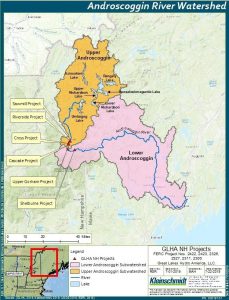
El Proyecto del Aserradero se ubica en el río Androscoggin, en el condado de Coos, al norte de Nuevo Hampshire. El río Androscoggin atraviesa los estados de Nuevo Hampshire y Maine. Se une al río Kennebec en la bahía Merrymeeting, en Maine, antes de desembocar en el golfo de Maine y posteriormente en el océano Atlántico. La cuenca del río Androscoggin alberga 19 proyectos hidroeléctricos ubicados a lo largo de sus 286 kilómetros de longitud.
El proyecto es uno de varios proyectos hidroeléctricos dentro de un alcance de 11 millas del río Androscoggin entre Berlín y Shelburne, New Hampshire, que incluyen: Potencia cruzada (LIHI #174), Cascada (LIHI #188), Alto Gorham (LIHI #175), Gorham (LIHI #153), y Shelburne (LIHI #176)El aserradero es el proyecto más avanzado en este tramo.
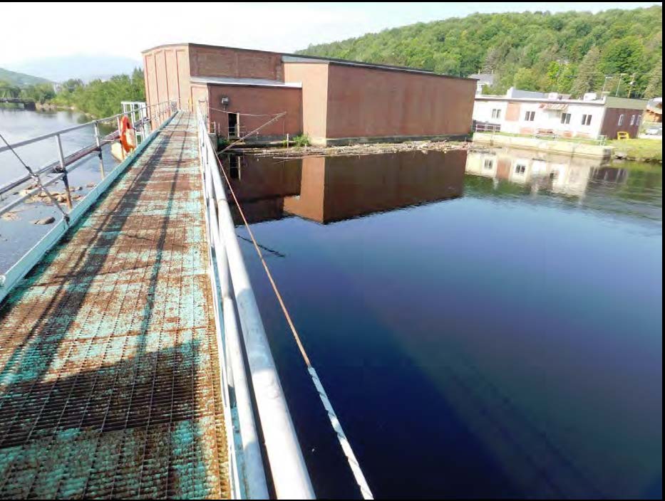
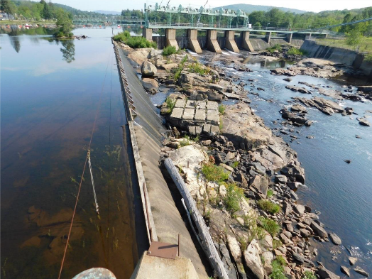
El proyecto incluye una presa, muros de contención de hormigón, toma canal, compuerta, central eléctricay equipos de transmisión. La presa Sawmill se construyó originalmente en 1903 y se renovó en 1965.
La presa tiene 22 metros de largo y una altura máxima de 4,5 metros. Está compuesta por una sección sin rebose de 41 metros de largo, una sección de hormigón de 52 metros de largo cuya altura varía entre 1,8 y 4,2 metros, y una sección de válvula de descarga de 41 metros de largo con cinco válvulas de madera. puertas cada uno de 22 pies de alto y 137 pies de largo aliviadero Sección con bisagra de 7,5 pies tableros de flashy un aliviadero de 44 metros de largo por 3,3 metros de alto con vierteaguas de acero de 53 cm. Un muro de contención de hormigón de 1,2 metros de ancho y 24 metros de largo, en la ribera este del río, separa el tramo de derivación de 0,5 km de longitud del canal de toma de la central eléctrica. Un muro de contención de 1,2 metros de ancho y 17 metros de largo se extiende desde el borde de la central eléctrica en la ribera oeste. El canal de toma de 118 metros de largo dirige las entradas a la central eléctrica a través de una tubería forzada de acero. La central eléctrica es una estructura de ladrillo y bloque, integral a la presa, que contiene:
- Cuatro bahías de entrada de turbinas de 4,25 m de ancho por 5,86 m de largo. Cada bahía pasa el flujo a través de rejillas de descarga de 4,25 m de ancho por 5,86 m de alto, cada una con una separación libre de 7,6 cm.
- Cuatro generadores horizontales idénticos. Las turbinas 1 y 3 son turbinas de hélice de palas fijas Allis-Chalmers. Las turbinas 2 y 4 son unidades de hélice de palas ajustables. La capacidad total es de 3,17 MW.
El proyecto opera en un marco cuasi-de pasada El proyecto crea un embalse de 72.5 acres. El embalse puede fluctuar en un rango de 6 pulgadas. El proyecto proporciona un caudal mínimo de 12 pies cúbicos por segundo (cfs) en el tramo desviado para facilitar el paso y proteger los recursos acuáticos. Este régimen de caudal se desarrolló en colaboración con el Servicio de Pesca y Vida Silvestre de los Estados Unidos (USFWS) y el Departamento de Servicios Ambientales de New Hampshire (NHDES).
Las aguas dentro del alcance del proyecto se clasifican como de Clase B, aptas para la pesca, la recreación de contacto primario y el suministro de agua después del tratamiento. Dichas aguas están catalogadas como contaminadas debido a vertidos previos de varias fábricas de papel. Dadas las operaciones de pasada, es improbable que el proyecto afecte negativamente la calidad del agua.
El río Androscoggin no es accesible para diádromo Especies de peces en el alcance del proyecto. Especies como la sábalo americano, el arenque de lomo azul, la lubina rayada, la lamprea marina y el sábalo americano no están presentes en el área debido a las cascadas naturales río abajo: Lewiston y Rumford Falls, en la parte de Maine del río. La anguila americana está presente en los tramos inferiores del río Androscoggin, aunque históricamente ninguna ha llegado a las secciones superiores del río. El área del proyecto sustenta el hábitat de la pesca de agua fría. El Departamento de Pesca y Caza de New Hampshire repobla anualmente truchas de arroyo, arcoíris y marrones río arriba de los proyectos. Las especies residentes del río incluyen el pez de río, la lubina de boca chica, el matalote blanco, el dace de hocico largo, el albur común, el albur de cola moteada y la perca amarilla. El paso río abajo puede ocurrir mediante el flujo del aliviadero, las liberaciones de compuertas de bajo nivel y el flujo de la toma de energía a través de las rejillas de basura. El proyecto no impide la finalización exitosa de los ciclos de vida de los peces residentes.
Los terrenos del proyecto se limitan al área ocupada por la infraestructura. El proyecto se ubica en el extremo norte de la ciudad de Berlín. La costa este del embalse está bordeada por terrazas de arena y grava, la mayoría de las cuales han sido alteradas por el desarrollo industrial, comercial y residencial, así como por la construcción de ferrocarriles y puentes. La costa este del embalse también se caracteriza por terrazas bajas y fue alterada por el patio de maniobras, la plataforma del ferrocarril, los patios de molinos y el desarrollo comercial y residencial. Las operaciones de pasada del proyecto protegen las zonas costeras.
Entre las especies amenazadas o en peligro de extinción que podrían estar presentes en las inmediaciones del proyecto se incluyen el murciélago orejudo norteño, el lince canadiense, el murciélago de patas pequeñas oriental, el murciélago café chico, el murciélago tricolor, el águila calva, la reinita de Cabo Mayo, el picogrueso vespertino, el mirlo herrumbroso, el zorzal de bosque, la tortuga de bosque, la marta americana, el halcón peregrino y el chotacabras común. Entre las especies vegetales se incluyen la twayblade aurículada, la cicely dulce de montaña, la juncia de punta ovoide, la juncia parasol, la shinleaf rosada, la enramada de la virgen púrpura, la orquídea de hojas redondas, el helecho liso de acantilado, el arándano enano, el helecho de bosque fragante, la twayblade de hojas de corazón y la hierba de sauce de Hornemann.
Es poco probable que las especies de murciélagos incluidas en la lista se vean afectadas por las operaciones del proyecto, ya que generalmente no se realizan actividades de desmonte ni mantenimiento del corredor. Se realizan algunas tareas de remoción de vegetación y mantenimiento para garantizar la seguridad de la presa, pero dichas actividades se ajustan a la norma 4(d) del USFWS sobre la protección del hábitat de las especies de murciélagos. La mayoría de las demás especies incluidas en la lista se han observado en las inmediaciones del proyecto, pero las operaciones de pasada y los límites de fluctuación del embalse mitigan cualquier impacto sobre estas especies.
El área del proyecto no alberga ningún recurso histórico ni cultural conocido. Sin embargo, el proyecto opera bajo un Acuerdo Programático (AP) en consulta con la Oficina Estatal de Preservación Histórica. El AP establece disposiciones que detallan el monitoreo y la presentación de informes anuales sobre las actividades de reparación y mejora realizadas, así como las actividades programadas para el año siguiente.
No hay instalaciones recreativas en el proyecto por motivos de seguridad, pero sí hay varias en sus inmediaciones. Justo al oeste de la presa Sawmill se encuentra el Parque Patrimonial del Bosque Norte, creado gracias a una donación de 12 acres del anterior propietario del proyecto. El parque ofrece excursiones por el río, eventos culturales, conciertos y fiestas. El Parque Rotary se encuentra junto al embalse y ofrece acceso a la costa. El Parque Centennial, ubicado en el embalse, ofrece acceso mediante una rampa para embarcaciones.
Estado de cumplimiento
El Certificado incluye las siguientes condiciones específicas de la instalación:
Condición cumplida en 2026. Condición 1: El Propietario de la instalación deberá informar a LIHI sobre el estado de la renovación de la licencia del Proyecto, incluyendo estudios, presentaciones ante la FERC, consultas con la agencia de recursos, prescripciones y recomendaciones, y comentarios de la agencia sobre los resultados de los estudios. LIHI se reserva el derecho de modificar el Certificado o las condiciones en función del resultado de la renovación de la licencia.
Condición 2:El propietario de la instalación deberá proporcionar actualizaciones a LIHI sobre el estado actual del Plan de Recreación Propuesto, incluidos los esfuerzos con el proyecto Riverwalk de la Ciudad de Berlín.
2025: No se identificaron cambios sustanciales ni problemas de cumplimiento. El proyecto se mantiene en cumplimiento según la revisión anual. Para la Condición 1, el proyecto proporcionó una actualización del estado y enlaces a los documentos de renovación de la licencia. La FERC emitió su Evaluación Ambiental final el 7 de octubre de 2024 y el NHDES emitió una certificación de calidad del agua el 19 de septiembre de 2024. Para la Condición 2, el proyecto informó que las mejoras en las áreas recreativas se incluirán en su plan de gestión de renovación de la licencia.
2024: No se identificaron cambios sustanciales ni problemas de cumplimiento. El proyecto se mantiene en cumplimiento según la revisión anual. Para la Condición 1, el proyecto proporcionó una actualización del estado y enlaces a los documentos de renovación de la licencia. La FERC emitió su borrador de Evaluación Ambiental el 23 de mayo de 2024. Para la Condición 2, el proyecto informó que se incluirán mejoras recreativas en su plan de gestión de renovación de la licencia.
2023: No se identificaron cambios sustanciales ni problemas de cumplimiento. El proyecto se mantiene en cumplimiento según la revisión anual. En cuanto a la Condición 1, el proyecto no reportó cambios en su estado. En cuanto a la Condición 2, el proyecto informó que se mantiene en consulta con la Ciudad. El proyecto reportó una desviación de caudal, que no se considera una infracción de la FERC.
2022: No se identificaron cambios sustanciales ni problemas de cumplimiento. El proyecto se mantiene en cumplimiento según la revisión anual. Para la Condición 1, el proyecto informó la presentación de la solicitud final de renovación de la licencia de la FERC el 29 de agosto de 2022. Para la Condición 2, el proyecto informó que se encuentra en proceso de consulta con la Ciudad.
2021: No se reportaron cambios ni problemas de cumplimiento. El proyecto se mantiene en cumplimiento según la revisión anual. Para la Condición 1, el proyecto reportó la presentación del informe inicial del estudio de renovación de la licencia. Para la Condición 2, el proyecto no reportó solicitudes de la ciudad ni cambios en el plan de recreación.
2020: La presentación de informes anuales para el Certificado actual aún no ha entrado en vigor.
Historial de certificaciones
28 de abril de 2026: El Instituto de Energía Hidroeléctrica de Bajo Impacto (LIHI) ha recibido una solicitud completa (véase más abajo) para una revisión intermedia del Proyecto Sawmill. Este proyecto es uno de varios proyectos certificados por el LIHI ubicados en la parte alta del río Androscoggin en New Hampshire, a los que la FERC otorgó nuevas licencias en septiembre de 2025. De acuerdo con la Sección 5.3.4 de la 2.ª edición del Manual del LIHI, la emisión de una nueva licencia constituye un “cambio sustancial” y da lugar a una revisión intermedia de la certificación del LIHI.
LIHI solicita comentarios del público sobre esta solicitud. Específicamente, nos interesa saber si usted cree que el Proyecto continúa cumpliendo con los Criterios de Certificación de Bajo Impacto de LIHI, tal como se revisaron en el Manual de la 2.ª edición. Los comentarios que estén directamente vinculados a criterios específicos de LIHI (caudales, calidad del agua, paso de peces, etc.) serán de gran ayuda, pero se tendrán en cuenta todos los comentarios. Los comentarios pueden enviarse a LIHI por correo electrónico a comments@lowimpacthydro.org con “Comentarios sobre el aserradero” en el asunto, o por correo postal dirigido al Low Impact Hydropower Institute, 68 Harrison Ave. Ste 605, PMB 113938, Boston MA 02111-1929.
Los comentarios deben recibirse antes de las 5 de la tarde, hora del este, del 27 de junio de 2026 para ser tenidos en cuenta. Todos los comentarios se publicarán en el sitio web y los solicitantes tendrán la oportunidad de responder. Cualquier respuesta también se publicará.
1 de enero de 2022: El plazo del Certificado LIHI se ha extendido de acuerdo con la Revisión 2.05 del Manual de Certificación LIHI 2.ª Edición emitido el 1 de enero de 2022. Consulte la tabla de instalaciones anterior para conocer el nuevo plazo.
30 de noviembre de 2020: La decisión de certificar el Proyecto Aserradero quedó firme tras el cierre del plazo de apelaciones el 27 de noviembre de 2020, sin que se presentaran apelaciones. El plazo de certificación es del 31 de agosto de 2020 al 30 de agosto de 2025.
27 de octubre de 2020:El Instituto de Energía Hidroeléctrica de Bajo Impacto (LIHI) aprobó preliminarmente la Certificación de Bajo Impacto para los Proyectos Hidroeléctricos Sawmill, Cross Power, Upper Gorham y Shelburne, ubicados en el río Androscoggin, New Hampshire. Esta decisión es preliminar, a la espera del plazo de apelación de 30 días. Solo quienes comentaron sobre la solicitud inicial durante el plazo de 60 días pueden presentar una apelación. Dicha apelación debe incluir una explicación de por qué el Proyecto no cumple con los criterios del LIHI. Las solicitudes de apelación para uno o más de estos proyectos pueden enviarse por correo electrónico a comments@lowimpacthydro.org Con el asunto "Proyectos del río Androscoggin-NH", o por correo postal dirigido al Instituto de Energía Hidroeléctrica de Bajo Impacto, 329 Massachusetts Ave, Suite 6, Lexington, MA 02420. Todas las solicitudes se publicarán en el sitio web. El solicitante tendrá la oportunidad de responder, y cualquier respuesta también se publicará. Las solicitudes deben recibirse antes de las 5 p. m., hora del Este, del 27 de noviembre de 2020. La solicitud completa y el informe de revisión están disponibles a continuación. Si no se reciben solicitudes de apelación, el período de certificación para cada proyecto será del 31 de agosto de 2020 al 30 de agosto de 2025.
13 de agosto de 2020: El Instituto de Energía Hidroeléctrica de Bajo Impacto (LIHI) ha recibido una solicitud completa para la Certificación de Bajo Impacto de los proyectos hidroeléctricos Sawmill, Cross Power, Upper Gorham y Shelburne, ubicados en el río Androscoggin en New Hampshire. LIHI solicita comentarios del público sobre esta solicitud. Específicamente, nos interesa saber si usted considera que los proyectos cumplen con los Criterios de Certificación de Bajo Impacto de LIHI, según la revisión de la 2.ª edición del Manual. La solicitud se encuentra disponible a continuación. Los comentarios directamente relacionados con criterios específicos de LIHI (caudales, calidad del agua, paso de peces, etc.) serán de gran utilidad, pero se considerarán todos los comentarios. Los comentarios pueden enviarse al Instituto por correo electrónico a comments@lowimpacthydro.org con “Comentarios sobre el Proyecto Androscoggin River-NH” en la línea de asunto, o por correo dirigido al Low Impact Hydropower Institute, 329 Massachusetts Avenue, Suite 6, Lexington, MA 02420. Los comentarios deben recibirse antes de las 5 p. m., hora del Este, el 12 de octubre de 2020 para ser considerados. Todos los comentarios se publicarán en el sitio web y el solicitante tendrá la oportunidad de responder. Las respuestas también se publicarán.
Archivos de certificación
Revisión de mitad de período de 2026
Certificación 2020
- Revisión de la certificación de proyectos de NH en Berlín 2020
- Solicitud de certificación de proyectos de Berlín NH 2020