Certificado LIHI #203 - Proyecto Skelton, Maine
| Nombre del proyecto | Skelton |
| Certificado LIHI No. |
203 |
| Plazo del certificado LIHI |
5 de marzo de 2025 – 4 de marzo de 2035 |
| Dueño | Brookfield White Pine Hydro, LLC (una subsidiaria de Brookfield Renewable Energy Group) |
| Estado | Maine |
| Ubicación | Milla fluvial 16 – Río Saco |
| Capacidad instalada | 21,6 MW |
| Generación media anual | 108.204 MWh |
| Tipo de instalación | Modificado estacionalmente de pasada |
| Comisión Federal de Comercio No. | P-2527. Licencia emitida en 1988, vence 31/01/2038. |
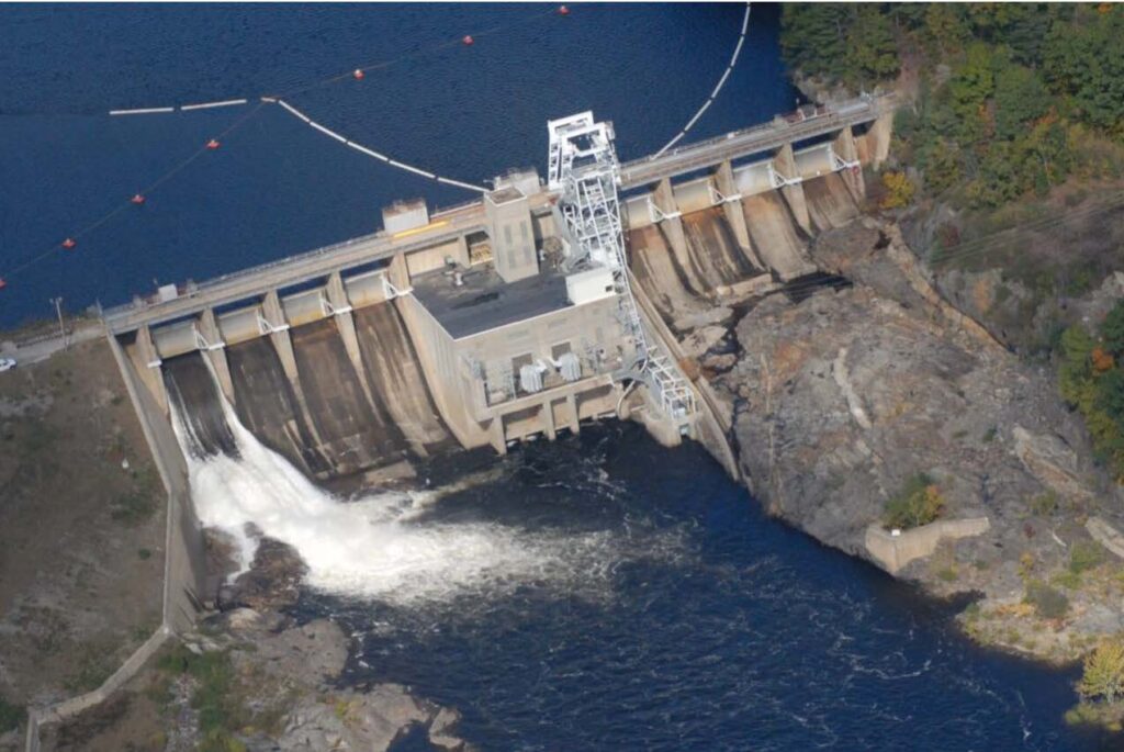
El Proyecto Skelton (FERC No. 2527) está ubicado en el río Saco en el condado de York, Maine, aproximadamente 11,1 millas fluviales por encima del nivel del mar. cabezade marea en Saco y a 16 millas fluviales desde la desembocadura del río en Camp Ellis/Hills Beach. El Proyecto presa y central eléctrica Se ubican en las localidades de Buxton y Dayton, Maine. El embalse se encuentra en las localidades de Buxton, Dayton y Hollis. El proyecto es la segunda presa en el río Saco y uno de los siete proyectos hidroeléctricos ubicados en el cauce principal del río.
El proyecto consiste en un túnel de hormigón de gravedad y tierra de 1.695 pies de largo. presa de terraplén Está rematada con una calzada y se construyó originalmente entre 1947 y 1949. La presa consta de: (1) una sección de terraplén de tierra, de 365 metros de largo por 18 metros de alto, con una elevación de coronación de 43 metros (USGS); (2) un mamparo oeste y aliviadero Sección de la puerta, de unos 170 pies de largo por 75 pies de alto, rematada con cuatro Tainter puertas, cada uno de 32,5 pies de ancho por 20 pies de alto, con una elevación de umbral de 108,0 pies (USGS); (3) una estructura de entrada, de 107 pies de largo por 146 pies de ancho, tiene dos aberturas de entrada, protegidas por rejillas de basura de barras de acero de 5/8 de pulgada en aberturas de 3 pulgadas; (4) una escala de peces y sección de compuerta, de unos 30 pies de largo; (5) un mamparo este y sección de compuerta de aliviadero, de unos 188 pies de largo por 75 pies de alto, rematado con cuatro compuertas Tainter, cada una de 32,5 pies de ancho por 20 pies de alto, con una elevación de umbral de 108,0 pies (USGS); y (6) un muro de contención de hormigón, que atraviesa el terraplén occidental de unos 763 pies de largo, con una elevación de cresta de 143,0 pies (USGS).
La presa forma un embalse ribereño de aproximadamente 4,5 km de largo y hasta 300 m de ancho. El embalse incluye aproximadamente 3,4 km del arroyo Cook en su confluencia con el río Saco. El límite del proyecto se extiende aguas arriba hasta el cauce del Proyecto Bar Mills (FERC n.° 2194) y aguas abajo hasta el embalse. Proyecto de Cataratas, LIHI #169Más arriba se encuentra el Proyecto Bonny Eagle (LIHI #182).
La central eléctrica es parte integral de la presa, que crea un embalse de 488 acres. La central eléctrica contiene dos unidades de turbina/generador Kaplan de eje vertical con una capacidad total de 21,6 MW. El proyecto opera como una instalación de pasada con modificación estacional. La operación del proyecto se gestiona en conjunto con el flujo y almacenamiento de agua de los proyectos aguas arriba, de conformidad con el Acuerdo de Caudal del Río Saco de 1997, como se detalla a continuación:
- Del 1 de abril al 30 de junio, el proyecto funciona en modo de pasada con solo 1 pie de fluctuación permitida con respecto al nivel normal del estanque lleno.
- Del 1 de julio al 30 de septiembre, el caudal mínimo aumenta a 400 pies cúbicos por segundo (cfs) cuando la entrada supera los 400 pies cúbicos por segundo. Cuando la entrada cae por debajo de 400 pies cúbicos por segundo, el proyecto continúa liberando 400 pies cúbicos por segundo extrayendo agua del embalse, con la reducción del nivel del embalse limitada a 4 pies o menos desde la elevación máxima del estanque. Una vez que la elevación del embalse cae 4 pies por debajo de la elevación máxima del estanque, el caudal de salida es igual a la entrada.
- Del 1 de octubre al 15 de noviembre (sujeto al período alternativo de 6 semanas aprobado por la agencia), el caudal mínimo aumenta a 600 cfs o entrada, lo que sea menor.
- Del 15 de noviembre al 31 de marzo, el caudal mínimo es de 400 pies cúbicos por segundo (cfs) cuando la entrada es superior a 400 pies cúbicos por segundo. Cuando la entrada cae por debajo de 400 pies cúbicos por segundo, el proyecto continúa liberando 400 pies cúbicos por segundo extrayendo agua del embalse, con la reducción del nivel del embalse limitada a 4 pies o menos desde la elevación máxima del estanque. Una vez que la elevación del embalse cae 4 pies por debajo de la elevación máxima del estanque, el caudal de salida es igual a la entrada.
El río Saco, en las inmediaciones del proyecto, es de Clase A, apto para los usos designados: agua potable tras su desinfección; pesca; agricultura; recreación acuática; suministro de agua para procesos industriales y refrigeración; generación de energía hidroeléctrica; y como hábitat para peces y otras especies acuáticas. El río en las inmediaciones del proyecto no está catalogado como contaminado. Se realizó un monitoreo de la calidad del agua y el Departamento de Protección Ambiental de Maine (DEP) confirmó que el proyecto cumple con su certificación de calidad del agua.
El proyecto está equipado con upstream y downstream. paso de peces Instalaciones instaladas en 2001. El paso de peces aguas arriba se realiza mediante un elevador de peces ubicado en el lado sur de la central hidroeléctrica, que consta de un sistema de agua de atracción, un sistema de concentración de peces, una tolva/elevador y sistemas de retención de camiones y trampas. El paso de peces aguas abajo se realiza mediante una compuerta de troncos de hormigón ubicada en el centro de la presa, equipada con una compuerta deslizante de 1,5 x 1,5 metros ubicada en la cabecera. El proyecto también cuenta con un paso de anguilas aguas arriba que entró en funcionamiento en 2013. Incluye una zona de flujo de agua de atracción de cemento rugoso en el lado este del aliviadero de Skelton que conduce a las anguilas juveniles a una rampa EnkaMat de 0,9 metros de largo y a un tanque elevador con una capacidad aproximada de 190 litros. El proyecto realiza paradas nocturnas durante la temporada de paso de anguilas aguas abajo.
Las tierras circundantes al proyecto son principalmente forestales o de uso agrícola. No existen tierras de importancia ecológica. De pasada Las operaciones y las fluctuaciones limitadas de los embalses sirven para limitar la erosión y sirven para beneficiar a los yacimientos existentes. humedales y la vida silvestre.
Las especies amenazadas o en peligro de extinción que pueden estar presentes incluyen la pogonia verticilada pequeña y la tortuga de Blanding (en peligro estatal). Otras especies propuestas para la lista incluyen el murciélago tricolor y la mariposa monarca. Otros murciélagos también pueden estar presentes, incluyendo el murciélago café pequeño en peligro estatal y el murciélago orejudo del norte (también en peligro federal), y el murciélago de patas pequeñas del este, amenazado por el estado. Las águilas calvas y otras aves migratorias también pueden estar presentes de forma periódica. Cuatro especies de plantas raras adyacentes al límite del proyecto: hierba joe-pye hueca; gaulteria moteada; pasto bromo peludo; y castaño americano. Es poco probable que las operaciones del proyecto afecten negativamente a ninguna especie protegida porque la eliminación de vegetación dentro de los 250 pies de cualquier vía fluvial está regulada por la Ley de Zonificación Costera del Departamento de Protección Ambiental de Maine y el proyecto normalmente no requiere talar árboles ni realizar actividades terrestres de mayor impacto.
Existen cuatro sitios arqueológicos en el área del proyecto que son elegibles para su inclusión en el Registro Nacional de Lugares HistóricosLa Licencia de la FERC exige la implementación del Acuerdo Programático de 1993 para proteger estos recursos. La revisión de los informes anuales exigidos por el Artículo 415 de los 10 años anteriores no reveló problemas relacionados con los recursos culturales o históricos del Proyecto.
Las instalaciones recreativas del proyecto incluyen una rampa para embarcaciones en la orilla oeste, aguas arriba de la presa, que también sirve como punto de acceso para el transporte, y un sendero de transporte con punto de acceso en la orilla oeste, aguas abajo del canal de descarga. Las instalaciones recreativas son gratuitas.
Estado de cumplimiento
El Certificado incluye las siguientes condiciones específicas de la instalación:
Condición 1El propietario de la instalación debe presentar a LIHI los resultados de sus estudios de efectividad del paso aguas arriba de 2025 y la documentación de los comentarios de la agencia sobre los resultados del estudio dentro de los 90 días posteriores a la publicación del informe final. En las presentaciones anuales posteriores de cumplimiento, se deben proporcionar a LIHI copias de todas las consultas y presentaciones relacionadas con cualquier modificación del paso requerida como resultado de los estudios de efectividad. LIHI se reserva el derecho de modificar o agregar condiciones, y de reevaluar el cumplimiento del criterio de paso aguas arriba con base en la información proporcionada.
Condición 2: El propietario de la instalación debe presentar a LIHI los resultados de sus estudios de efectividad del paso aguas abajo de 2025 y 2026, así como la documentación de los comentarios de la agencia sobre los resultados del estudio, en actualizaciones trimestrales de cumplimiento hasta que se completen los estudios. En las presentaciones anuales posteriores de cumplimiento, se deben proporcionar a LIHI copias de todas las consultas y presentaciones relacionadas con cualquier modificación del paso requerida como resultado de los estudios de efectividad. LIHI se reserva el derecho de modificar o añadir condiciones, y de reevaluar el cumplimiento del criterio de paso aguas arriba con base en la información proporcionada.
2026: No se identificaron cambios sustanciales ni problemas de cumplimiento. El proyecto sigue cumpliendo con los requisitos según la revisión anual. En cuanto a la Condición 1, el proyecto presentó a las agencias los resultados preliminares del estudio de paso de alosina y está a la espera de comentarios. Se elaborará un plan de estudio para 2026. Respecto a la Condición 2, el proyecto informó que el estudio de anguilas aguas abajo de 2025 se pospuso debido a la escasez de peces disponibles, pero se realizó un estudio piloto a menor escala. Los resultados se presentaron a las agencias y el proyecto está a la espera de sus comentarios.
2025: La presentación de informes anuales para el Certificado actual aún no ha entrado en vigor.
Historial de certificaciones
6 de agosto de 2025El Instituto de Energía Hidroeléctrica de Bajo Impacto ha emitido una decisión final sobre la certificación del Proyecto Hidroeléctrico Skelton. No se recibieron apelaciones durante el período de apelación, que cerró el 31 de julio de 2025. El plazo de certificación de 10 años es del 5 de marzo de 2025 al 4 de marzo de 2035.
1 de julio de 2025: El Instituto de Energía Hidroeléctrica de Bajo Impacto (LIHI) ha aprobado preliminarmente la Certificación de Bajo Impacto para el Proyecto Hidroeléctrico Skelton (pendiente de LIHI #203). La solicitud completa y el informe del revisor están disponibles a continuación. Esta decisión es preliminar, a la espera del plazo de apelación de 30 días. Solo quienes presentaron comentarios sobre las solicitudes iniciales durante el plazo de 60 días pueden presentar una apelación. Dicha apelación debe incluir una explicación de por qué los proyectos no cumplen con los criterios de LIHI. Las solicitudes de apelación pueden enviarse por correo electrónico a mailto:comments@lowimpacthydro.org Con el asunto "Proyecto Skelton", o por correo postal dirigido al Instituto de Energía Hidroeléctrica de Bajo Impacto, 68 Harrison Ave Ste 605, PMB 113938, Boston, Massachusetts 02111-1929. Todas las solicitudes se publicarán en el sitio web. El solicitante tendrá la oportunidad de responder, y cualquier respuesta también se publicará. Las solicitudes deben recibirse antes de las 17:00 h, hora del este, del 31 de julio de 2025. Si no se reciben solicitudes de apelación, el plazo de certificación será del 5 al 4 de marzo de 2025.
6 de marzo de 2025: El Instituto de Energía Hidroeléctrica de Bajo Impacto (LIHI) ha recibido una solicitud completa para la Certificación de Bajo Impacto del Proyecto Hidroeléctrico Skelton. LIHI solicita comentarios públicos sobre esta solicitud. En concreto, nos interesa saber si considera que el Proyecto cumple con los Criterios de Certificación de Bajo Impacto de LIHI, revisados en la 2.ª edición del Manual vigente al momento de la solicitud inicial. Por favor, revise el programa y los criterios en el sitio web de LIHI. Revisión del manual 2.05y luego revise los materiales de solicitud del Proyecto a continuación. Los comentarios directamente relacionados con criterios específicos del LIHI (caudales, calidad del agua, paso de peces, etc.) serán de gran ayuda, pero todos los comentarios serán considerados. Los comentarios pueden enviarse al Instituto por correo electrónico a comments@lowimpacthydro.org con “Comentarios del Proyecto Skelton” en la línea de asunto, o por correo dirigido al Low Impact Hydropower Institute, 68 Harrison Ave Ste 605, PMB 113938 Boston, Massachusetts 02111-1929. Los comentarios deben recibirse antes de las 5 p. m., hora del Este, del 5 de mayo de 2025. Se considerarán todos los comentarios. Se publicarán en el sitio web y el solicitante tendrá la oportunidad de responder. También se publicarán todas las respuestas.
Archivos de certificación
Solicitud 2025
- Informe de revisión de la certificación Skelton 2025
- Solicitud de Skelton LIHI
- Comentarios de la TU
- Comentarios de seguimiento de TU
- Respuesta de Brookfield a los comentarios de TU
- Río Saco 2024 Diádromo Paso de peces Informe
Documentos clave
- Licencia FERC y certificado de calidad del agua de Skelton, 1998
- Acuerdo sobre el caudal del río Saco de 1997
- Declaración de Impacto Ambiental de la FERC del río Saco de 1996
- Enmienda del Acuerdo de Evaluación Pesquera del Río Saco de 2019
- Acuerdo de evaluación de la pesca del río Saco de 2007
- Acuerdo sobre el paso de peces del río Saco de 1994