Certificado LIHI #156 – Proyecto Piercefield, Nueva York
| Nombre del proyecto | Piercefield |
| Certificado LIHI No. |
156 |
| Plazo de certificación de LIHI |
26 de abril de 2019 – 25 de abril de 2029 |
| Dueño | Erie Boulevard Hydropower, LP, una subsidiaria de Brookfield Renewable Energy Group |
| Estado | Nueva York |
| Ubicación | Milla fluvial 88,5 en el río Raquette |
| Capacidad instalada | 2,7 MW |
| Generación media anual | 16.520 MWh |
| Tipo de instalación | Modificado correr del río |
| Comisión Federal de Comercio No. | P-7387 emitido en 2005, vence el 31/10/2035 |
El Proyecto Piercefield se ubica en el río Raquette, cerca de la ciudad de Piercefield, en los condados de Franklin y St. Lawrence, Nueva York. El proyecto... presa y central eléctrica Fueron construidas originalmente en 1899 por la International Paper Company para suministrar energía mecánica al proceso de fabricación de papel. La instalación se convirtió en una central eléctrica en 1926. A principios del siglo XX y a finales de la década de 1970, se realizaron varias modificaciones para sustituir las secciones de madera de las estructuras por estructuras de hormigón más resistentes.
El río Raquette tiene una cuenca de drenaje total de 1269 millas cuadradas en su desembocadura y nace en las tierras altas de Adirondack, en los lagos Blue Mountain, Raquette y Long. El río fluye generalmente en dirección norte-noroeste durante más de 235 kilómetros, atravesando Potsdam, Nueva York, y desembocando en el río San Lorenzo, cerca de Massena, Nueva York.
Existen un total de 19 proyectos hidroeléctricos en el río Raquette, la mayoría de los cuales son propiedad del propietario del proyecto, incluso desde aguas arriba hasta aguas abajo. Yaleville (LIHI #157), Raqueta Superior (LIHI #14A), Raqueta Media (LIHI #14B), y Raqueta Inferior (LIHI #14C)El proyecto en sí es la presa más al sur y situada más arriba del río.
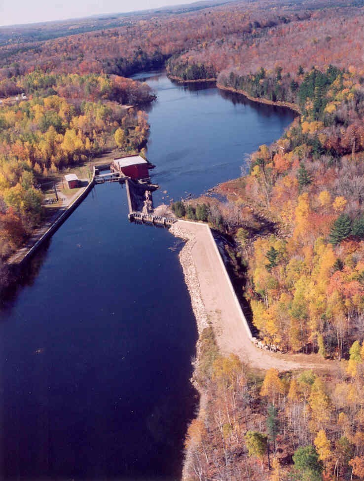
El proyecto incluye: la presa, el muro de contención, el tronco de contención. aliviadero, ojiva aliviadero, tramo desviado, central eléctrica, una vertical Turbina Francis, y dos dobles horizontales Turbinas Francis./p>
La presa es de hormigón y madera, de 7 metros de altura y aproximadamente 91 metros de longitud, con un muro de contención/dique de 150 metros de longitud en la orilla derecha. Un muro de contención de 213 metros de longitud se encuentra a lo largo de la orilla izquierda. aliviaderos Incluye un tipo de puntal de 118 pies de largo Detener registro aliviadero y una sección de aliviadero ogee de 294 pies de largo y 23 pies de alto con un aliviadero inflable Obermeyer de 2 pies de alto tablero de flash Sistema y un muro de contención de cámara de carga de 33 metros de largo. La presa crea un tramo desviado de 167 metros de largo. La central eléctrica contiene una unidad Francis vertical y dos unidades Francis dobles horizontales con una capacidad combinada de 2,7 MW.
El proyecto opera de forma modificada de pasada y embalsa un embalse de 370 acres que se extiende 1,9 millas río arriba. El proyecto proporciona un caudal mínimo de 150 pies cúbicos por segundo en el canal de descarga y las fluctuaciones del embalse se mantienen a menos de 1 pie del borde superior. tableros de flashEste régimen de caudal se desarrolló en colaboración con el Departamento de Conservación Ambiental del Estado de Nueva York (NYSDEC), el Servicio de Pesca y Vida Silvestre de los Estados Unidos (USFWS), la Agencia del Parque Adirondack y New York Rivers United. Las partes involucradas coinciden en que este régimen de caudal proporciona un hábitat adecuado aguas abajo y mantiene una barrera vegetal estable alrededor del embalse. Se añaden 20 pies cúbicos por segundo (cfs) más abajo en el tramo desviado para generar caudales de atracción lejos de las tomas y minimizar la pesca. arrastre y proporcionar paso río abajo.
Las aguas dentro del alcance del proyecto están designadas como Clase C. No hay aguas deterioradas en las cercanías del proyecto y NYSDEC ha confirmado que el proyecto continúa cumpliendo con todos los grupos de uso designados.
Las cascadas y los elementos acuáticos aguas abajo crean barreras naturales para el paso de las especies migratorias de peces en el proyecto. El tramo del proyecto sustenta las poblaciones de peces residentes de perca amarilla, lucioperca americana, róbalo de roca, lubina de boca chica, corégono de lago, pez de río y carite dorado. La lucioperca americana es particularmente abundante en el área del proyecto. El requisito de caudal mínimo de 150 pies cúbicos por segundo (cfs) sustenta los recursos pesqueros aguas abajo del proyecto y la derivación de peces de 20 pies cúbicos por segundo (cfs) aguas abajo proporciona un paso adecuado, y las rejillas de basura con una separación de 2.5 cm (1 pulgada) mitigan el potencial de arrastre. Este diseño fue aprobado por el Departamento de Conservación Ambiental del Estado de Nueva York (NYSDEC) y el Servicio de Pesca y Vida Silvestre de los Estados Unidos (USFWS) para la protección del paso aguas abajo.
Los terrenos del proyecto abarcan aproximadamente 18 acres, ubicados en el Parque Estatal Adirondack, y se rigen por la Parte 577 de la Ley de Ríos Salvajes, Escénicos y Recreativos, que restringe el desarrollo de nuevas estructuras, promueve la gestión forestal y exige una zona de amortiguación en las orillas del río. El proyecto opera bajo un plan de monitoreo del caudal y el nivel del agua que minimiza los efectos en la costa al limitar las fluctuaciones del embalse. Esto garantiza una adecuada protección vegetal en la costa y minimiza la erosión.
Las especies amenazadas o en peligro de extinción que podrían estar presentes en las inmediaciones del proyecto incluyen el murciélago orejudo norteño, el águila calva y el urogallo canadiense. El proyecto cumple con la Norma 4(d) del Servicio de Pesca y Vida Silvestre de los Estados Unidos (USFWS) sobre la protección de las poblaciones de murciélago orejudo norteño, así como con el Plan de Conservación del Departamento de Conservación Ambiental del Estado de Nueva York (NYSDEC) para las águilas calvas. Estas disposiciones establecen principalmente que se evite la tala de árboles durante períodos específicos de anidación. El NYSDEC también determinó que el proyecto no tiene ningún impacto en las poblaciones de urogallo canadiense. Tras consultar con el NYSDEC en 2019, se concluyó que las poblaciones de águilas calvas se encuentran en muy buen estado en Nueva York y que las operaciones del proyecto no representan ninguna amenaza para su éxito.
Las propiedades históricas en el área del proyecto incluyen la presa y la central eléctrica de Piercefield, construidas en 1899 por International Paper Company para producir papel periódico. El propietario del proyecto desarrolló un plan de gestión de propiedades históricas en consulta con la Oficina Estatal de Preservación Histórica (SHPO) para identificar propiedades históricas, brindar mantenimiento preventivo y facilitar mejoras. El propietario del proyecto capacitó a su personal operativo para que proporcione actualizaciones semanales de monitoreo de las propiedades históricas y presente informes anuales a la SHPO.
Los recursos recreativos del proyecto incluyen una rampa para embarcaciones, zonas de entrada y salida de canoas y dos zonas designadas para pesca de orilla. El propietario del proyecto ofrece una descarga recreativa de 750 pies cúbicos por segundo durante cinco horas el último sábado de junio. El acceso público es gratuito.
Estado de cumplimiento
No existen condiciones específicas de la instalación en el Certificado actual
2026: No se identificaron cambios sustanciales ni problemas de cumplimiento. El proyecto se mantiene en cumplimiento según la revisión anual.
2025: No se identificaron cambios sustanciales ni problemas de cumplimiento. El proyecto se mantiene en cumplimiento según la revisión anual.
2024: No se identificaron cambios sustanciales ni problemas de cumplimiento. El proyecto se mantiene en cumplimiento según la revisión anual.
2023: No se identificaron cambios sustanciales ni problemas de cumplimiento. El proyecto se mantiene en cumplimiento según la revisión anual.
2022: No se identificaron cambios sustanciales ni problemas de cumplimiento. El proyecto se mantiene en cumplimiento según la revisión anual.
2021: No se informaron cambios ni problemas de cumplimiento. El proyecto sigue cumpliendo con los requisitos según la revisión anual.
2020: No se informaron cambios ni problemas de cumplimiento. El proyecto sigue cumpliendo con los requisitos según la revisión anual.
2019: La presentación de informes anuales para el Certificado actual aún no ha entrado en vigor.
Historial de certificaciones
1 de enero de 2022: El plazo del Certificado LIHI se ha extendido de acuerdo con la Revisión 2.05 del Manual de Certificación LIHI 2.ª Edición emitido el 1 de enero de 2022. Consulte la tabla de instalaciones anterior para conocer el nuevo plazo.
13 de agosto de 2019: La decisión de certificar el Proyecto Hidroeléctrico Piercefield es definitiva. No se recibieron apelaciones durante el período de apelación, que cerró el 9 de agosto de 2019. El nuevo plazo de certificación del Proyecto es del 26 de abril de 2019 al 25 de abril de 2024.
10 de julio de 2019: El Instituto de Energía Hidroeléctrica de Bajo Impacto ha aprobado preliminarmente la Certificación de Bajo Impacto para el Proyecto Hidroeléctrico Piercefield.
Esta decisión es preliminar y está pendiente del período de apelación de 30 días. Solo aquellos que comentaron sobre la solicitud inicial durante el período de comentarios de 60 días son elegibles para presentar una apelación. Dicha apelación debe incluir una explicación de por qué el Proyecto no cumple con los criterios de LIHI. Las solicitudes de apelación se pueden enviar por correo electrónico a comments@lowimpacthydro.org Con el asunto "Proyecto Hidroeléctrico Piercefield", o por correo postal dirigido al Instituto de Energía Hidroeléctrica de Bajo Impacto, 329 Massachusetts Ave, Suite 6, Lexington, MA 02420. Todas las solicitudes se publicarán en el sitio web. El solicitante tendrá la oportunidad de responder, y cualquier respuesta también se publicará. Las solicitudes deben recibirse antes de las 5 p. m., hora del Este, el 9 de agosto de 2019. La solicitud completa y el informe de los revisores están disponibles a continuación.
Si no se reciben solicitudes de apelación y la decisión es definitiva, el plazo de Certificación del Proyecto (pendiente LIHI #156) será el 26 de abril de 2019 por un período de cinco (5) años, que vencerá el 25 de abril de 2024.
1 de mayo de 2019: El Instituto de Energía Hidroeléctrica de Bajo Impacto (LIHI) ha recibido una solicitud completa para la Certificación de Bajo Impacto del Proyecto Hidroeléctrico Piercefield. LIHI solicita comentarios públicos sobre esta solicitud. En concreto, nos interesa saber si considera que el Proyecto cumple con los Criterios de Certificación de Bajo Impacto de LIHI, revisados en la 2.ª edición del Manual. Por favor, revise el programa y los criterios en la versión revisada de LIHI. Manual y luego revise los materiales de solicitud del Proyecto a continuación.
Comentarios que están directamente relacionados con criterios específicos de LIHI (caudales, calidad del agua, paso de peces, etc.) serán de gran ayuda, pero se tendrán en cuenta todos los comentarios. Los comentarios pueden enviarse al Instituto por correo electrónico a comments@lowimpacthydro.org con “Comentarios del Proyecto Piercefield” en la línea de asunto, o por correo dirigido al Low Impact Hydropower Institute, 329 Massachusetts Avenue, Suite 6, Lexington, MA 02420. Los comentarios deben recibirse antes de las 5 p. m., hora del Este, el 30 de junio de 2019. Se considerarán todos los comentarios. Se publicarán en el sitio web y el solicitante tendrá la oportunidad de responder. También se publicarán todas las respuestas.
Archivos de certificación
Certificación 2019
- Informe de revisión de la certificación de Piercefield 2019
- Solicitud de certificación de Piercefield 2019