LIHI 證書 #32 - 紐約牛頓瀑布項目
| 項目名稱 | 牛頓瀑布 |
| 理海證書編號 | 32 |
| LIHI 證書期限 | 2017年11月2日 – 2027年11月1日 |
| 擁有者 | Erie Boulevard Hydropower, LP,布魯克菲爾德再生能源集團的子公司 |
| 狀態 | 紐約 |
| 地點 | 位於紐約州聖勞倫斯縣克利夫頓鎮奧斯威加奇河 99.1 英里和 99.6 英里之間。 |
| 裝置容量 | 總計:2.22 兆瓦 上牛頓瀑布:1.54兆瓦 下牛頓瀑布:0.68兆瓦 |
| 平均年發電量 | 8,982 兆瓦時 |
| 設施類型 | 上牛頓: 尖峰 和/或負載追蹤模式 下牛頓: 徑流 |
| 聯邦能源監管委員會 不。 | P-7000 於 2003 年簽發,效期至 2044 年 1 月 31 日 |
牛頓瀑布計畫由兩個開發案組成(上牛頓瀑布和下牛頓瀑布),位於紐約州聖勞倫斯縣克利夫頓鎮的奧斯威戈奇河上。最初的 木製嬰兒床 工程所在地的水壩建於1895年,並於1920年代末期被現有水壩取代。這兩座水壩均為發電用途,自建成以來,其各方面已多次修復。奧斯威戈奇河上有17座水壩。克蘭伯里湖水力發電計畫位於該計畫上游,下游還有幾個計畫。其中包括 奧斯威戈奇計畫 (LIHI #161).
此項目包括兩個發展項目:
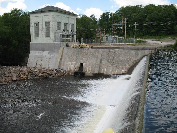
- 上牛頓瀑布:混凝土 重力 壩 長約600英尺,最大高度50英尺。大壩的組成部分包括南側非溢流段、後張錨定非控制混凝土 弧形 重力段,四開間洩水閘結構, 滑動 蓋茲 (也採用後張拉錨固)、進水口及北側非溢流段。進水口為鋼筋混凝土重力結構,尺寸約36英尺×45英尺,最大高度為25英尺。 壓力水管 是一個直徑9英尺、長1200英尺的鋼帶木條壓力水管,在木泥坎上設有木支架。調壓箱是一個鉚接鋼製差壓箱結構,位於壓力水管三叉上游,進入 發電站發電站由鋼筋混凝土下部結構和磚砌上部結構組成,裝有三台萊菲爾「Z」型渦輪機,總裝置容量為 1.54 兆瓦。
- 下牛頓瀑布:該項目大壩是一座 350 英尺長、24 英尺高的混凝土重力壩,頂部有 閃光板,一座佔地9英畝的水庫,總庫容115英畝英尺,設有300英尺長的繞行河段,以及一座單機組發電廠。大壩的組成部分,由左至右,面向下游,依序為左堤/核心牆段、弧形壩段 溢洪道 帶有擋水板、前池牆、一體式發電站/進水口以及用於擋住通道/停車場填土的混凝土擋土牆。溢洪道為混凝土重力式弧形壩段,總長120英尺,最大高度約24英尺(至結構非溢流端頂部28英尺)。左堤為土回填核心牆結構,長約125英尺。前池牆位於溢洪道右側,用作進水口的導牆。其長約80英尺,頂部高程為1,376.5英尺。前池牆上設有一個3英尺見方的閘門,由頂部有手動操作裝置的升降閘門控制。進水口右側有一道混凝土重力式擋土牆,用於擋住通往發電站的車道,並用作進水口的導牆。該牆長約88英尺。進水口與發電站的上游面融為一體。進水口結構為鋼筋混凝土結構,寬約20英尺,高約15英尺。進水口設有三個艙室,由三個垂直螺旋桿升降閘門控制。沒有 壓力管道 或者 水槽 該項目。發電站和進水口為一體式結構。發電站採用單一萊費爾Z型水輪機,裝置容量為0.68兆瓦。
上牛頓瀑布開發案位於 達到峰值/負載追蹤模式,並透過下游提供全年最低流量 20 立方英尺/秒 魚道 出口。下牛頓瀑布開發案是在 徑流 模式,最低流量為 100 立方英尺/秒。此最低流量可透過溢洪道或渦輪機(流量充足時)實現。此流量模式由美國魚類及野生動物管理局 (USFWS) 和紐約州環境保護部 (NYSDEC) 根據上一輪重新許可期間進行的示範流量研究共同製定。
該項目上游水域被指定為A(t)級,適合飲用、烹飪、休閒娛樂以及魚類繁殖/生存。 (t)級劃分也顯示該水域可能支持鱒魚種群的生存。項目下游水域被指定為C級。 C級水域適合休閒娛樂,也適合魚類繁殖和生存。
計畫區域內的幾個天然瀑布歷來阻礙了洄游魚類的遷徙。早在1931年進行的漁業調查就指出,沒有溯河洄游魚類或 洄游性 計畫區域內存在魚類物種。上游牛頓瀑布的鋼製擋水板為下游居民提供了魚道,擋水板有凹槽,可釋放20立方英尺/秒的魚道水流,從而形成 瀑布水潭 位於溢洪道底部。下牛頓瀑布開發區還設有通道,透過水閘上的缺口,釋放20立方英尺/秒的魚道水流,通往現有的水池。該結構和水道水流是在美國魚類及野生動物管理局和紐約州環境保護署的諮詢下開發的,旨在提供有效的魚道。常駐魚類包括大口黑鱸和小口黑鱸、梭子魚、吸盤魚、鰷魚,以及溪鱒、褐鱒和虹鱒。
工程用地面積不到2英畝。專案所有權範圍內的土地有限,並受專案海岸線侵蝕監測計畫的監管。該計畫重點關注牛頓瀑布上游的開發,並包含對河流附近可能蘊藏考古資源的區域進行保護的規定。蓄水監測系統確保蓄水量波動限制在每分鐘0.1英尺以內,從而最大限度地降低海岸線侵蝕的可能性。
計畫附近可能存在的受威脅或瀕危物種包括北長耳蝠、白頭鷹和北蘆葦。對蝙蝠物種的主要關注點在於樹木砍伐。該項目提供了一個林地緩衝區,確保對該物種進行適當的保護。紐約州環境保護部就對白頭鷹個體的潛在影響進行了諮詢,該機構報告稱,該項目運營不太可能對該物種或其築巢棲息地造成任何影響。紐約州的白頭鷹族群「狀況良好」。
計畫區域內唯一的文化資源可能位於上述上牛頓瀑布開發案附近的區域。這片土地具有豐富的考古資源潛力,必須持續密切注意。除此之外,州歷史保護辦公室也不擔心專案運作會對計畫週邊的歷史建築造成潛在影響。
此計畫的休閒資源包括車頂船下水處、獨木舟進出區和停車區。免費對外開放。
合規狀態
此證書包括以下設施特定條件:
2018 年條件滿足。 條件一: 業主應在下游開發案的繞行河段安裝並製定標尺或紀念碑的流量額定值,並應按照 FERC 於 2008 年 11 月 4 日發出的第 404 條規定向資源機構和 FERC 提供該額定值。竣工確認書應於 2018 年 12 月 31 日前提交給 LIHI。如果未能在該日期前完全滿足此要求,LIHI 可暫停或撤銷認證,除非能證明任何額外的延誤是由於業主無法控制的因素造成的。
2025: 未發現重大變更或合規問題。根據年度審查,該項目仍符合規定。
2024: 未發現重大變更或合規問題。根據年度審查,該項目仍符合規定。
2023: 未發現重大變更或合規問題。根據年度審查,該項目仍符合規定。
2022: 未發現重大變更或合規問題。根據年度審查,該項目仍符合規定。
2021: 沒有報告變更或合規問題。根據年度審查,該項目仍符合規定。
2020: 沒有報告變更或合規問題。根據年度審查,該項目仍符合規定。
2019: 沒有報告變更或合規問題。根據年度審查,該項目仍符合規定。
2018: 未報告任何變更或合規問題。根據年度審查,該項目仍然合規。對於條件1,該項目已確認安裝員工紀念碑,因此滿足條件。
2017: 目前證書的年度報告尚未生效。
認證歷史
2022 年 1 月 1 日: 根據 2022 年 1 月 1 日發布的 LIHI 第二版認證手冊第 2.05 版,LIHI 證書期限已延長。
2018 年 7 月 6 日 牛頓瀑布水力發電計畫初步認證決定的30天申訴期已於2018年7月5日結束,目前未收到任何針對該決定的申訴。因此,該決定為最終決定,牛頓瀑布水力發電計畫重新認證有效期為2017年11月2日至2022年11月1日。
2018年6月5日: 低影響水力發電研究所 (LIHI) 初步批准牛頓瀑布水力發電計畫獲得為期 5 年的新低影響認證。此決定尚處於初步階段,需等待 30 天的申訴期結束。只有在 60 天的評論期內對初始申請發表意見的人員才有資格提出申訴。此類申訴需要說明為何該項目不符合 LIHI 標準。申訴請求可以透過電子郵件發送至 comments@lowimpacthydro.org 主旨行請註明“牛頓瀑布水力發電計畫”,或郵寄至低影響水力發電研究所,地址:329 Massachusetts Ave, Suite 2, Lexington, MA 02420。所有請求都將發佈在網站上,申請人將有機會回應,任何回應也將公佈。 請求必須在 2018 年 7 月 5 日東部時間下午 5 點前收到。 完整的申請和審核報告如下。如果沒有收到上訴請求,且該決定成為最終決定,牛頓瀑布計畫的新期限將為2017年11月2日至2022年11月1日。
2018年3月13日: 低影響水力發電研究所 (LIHI) 已收到一份完整的申請,申請針對牛頓瀑布水力發電計畫進行新一期低影響認證。該項目位於紐約州聖勞倫斯縣克利夫頓鎮的奧斯威戈奇河畔,距離該河與聖勞倫斯河交匯處上游約 98 英里。 LIHI 正在就此申請徵詢公眾意見。具體而言,我們想知道您是否認為該項目符合 LIHI 低影響認證標準(第二版手冊中修訂版)。請查看 LIHI 修訂版中的項目和標準。 手冊 然後查看下面發布的該項目 2018 年申請資料。與特定 LIHI 標準(流量、水質、魚類通道等)直接相關的評論將最有幫助,但所有評論都會被考慮。意見可以透過電子郵件提交給研究所 comments@lowimpacthydro.org 請在主旨欄註明“Newton Falls Comments”,或郵寄至 Low Impact Hydropower Institute, 329 Massachusetts Avenue, Suite 2, Lexington, MA 02420。 評論必須在 2018 年 5 月 12 日美國東部時間下午 5 點之前送達研究所 予以考慮。所有評論都將發佈到網站上,申請人將有機會回應。任何回應也將被發布。
2018年3月13日: 牛頓瀑布水力發電計畫已獲準將目前期限延長至 2018 年 6 月 30 日。
2012年12月29日: 牛頓瀑布計畫已重新認證為低影響項目,第二個五年期限從 2012 年 11 月 2 日生效,至 2017 年 11 月 2 日到期。
2008年2月29日: 牛頓瀑布計畫已認證為低影響項目,有效期為五年,自 2007 年 11 月 2 日生效,至 2012 年 11 月 2 日到期。
2007年11月1日: 布魯克菲爾德電力公司已提交牛頓瀑布水力發電計畫認證申請。