LIHI 證書 #157 – 紐約耶魯維爾項目
| 項目名稱 | 耶魯維爾 |
| 理海證書編號 |
157 |
| LIHI 證書期限 |
2019年4月26日 – 2029年4月25日 |
| 擁有者 | Erie Boulevard Hydropower, LP,布魯克菲爾德再生能源集團的子公司 |
| 狀態 | 紐約 |
| 地點 | 拉奎特河 25.5 英里河段 |
| 裝置容量 | 0.7 兆瓦 |
| 平均年發電量 | 3,800 兆瓦時 |
| 設施類型 | 河流的奔流 |
| 聯邦能源監管委員會 不。 | P-9222 簽發於 1992 年,效期至 2033 年 12 月 31 日 |
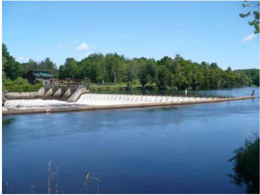
耶魯維爾計畫位於紐約州富蘭克林縣和聖勞倫斯縣耶魯維爾鎮附近的拉奎特河上。該項目最初於 1903 年建造,其唯一目的是發電。在整個 20 世紀,該計畫進行了多次改進。這包括新的混凝土 水槽 1919年;具體 壩 把木壩和水車換成了現在的水力發電設備;一個新的 發電站 建於1922年;1977年建造了前池並鋪設了渦輪機房地板;這 溢洪道 和 運河 1978年重建城牆;尾水 停止日誌 1982年對結構和尾水進行了修復;並對脫水設施進行了混凝土修復。這些升級在 1987 年達到頂峰,安裝了新的 頭 蓋茲 以及工程進水口處的閘門升降架。
拉奎特河口總流域面積為 1,269 平方英里,發源於阿迪朗達克高地的藍山湖、拉奎特湖和長湖。這條河大致向北偏西北流動,流經紐約州波茨坦,全長超過 146 英里,最後流入紐約州馬塞納附近的聖勞倫斯河。
拉奎特河上共有19個水力發電項目,其中大部分由專案業主擁有,包括上游至下游, 皮爾斯菲爾德 (LIHI #156), 上拉奎特 (LIHI #14A), 中拉奎特 (LIHI #14B), 和 下拉奎特 (LIHI #14C)。耶魯維爾計畫位於拉奎特河下游計畫的諾伍德開發區和東諾福克開發區之間。
該項目包括一座大壩、防洪閘結構、旁路河段、進水口結構、前池、發電站和兩台發電機組。
大壩為混凝土重力溢流壩,長約 170 英尺,高 13 英尺,壩高 1.5 英尺 閃光板 頂部有一座混凝土重力式防洪閘結構,長 75 英尺,由四個支柱隔間組成,每個支柱隔間長 15 英尺,高 10 英尺。每個支柱隔間均有一個中央工字梁支撐,形成兩個 7.5 英尺隔間,總共 8 個隔間。每個單獨的隔間都有 10 英尺高的水平木材擋水板,頂部有一個 5 英尺高的鋼製滑動門,大壩形成了一個長約 485 英尺的旁路河段。水透過 60 英尺寬、275 英尺長的前池(運河)輸送到進水口。進水口結構與發電站上游側融為一體。該發電站包含兩台立式弗朗西斯機組,總容量為 0.725 兆瓦。
該項目採用 徑流 模式並攔截一個面積為 95 英畝的水庫,該水庫向上游延伸約 1.8 英里。 魚道 春季徑流後,重新安裝擋水板(每年 5 月 15 日左右)直至 11 月 1 日,流量保持在 36 立方英尺/秒。 扣押 專案業主會監控水位波動,並進行營運調整以確保符合徑流規律。該流動制度是根據美國魚類和野生動物管理局 (USFWS) 的建議制定的,旨在為當地魚類物種保留合適的水生棲息地。紐約州環境保護局 (NYSDEC) 將拉奎特河作為混合溫水/冷水漁業資源進行管理。
計畫河段水域被指定為 B 類,管理優質水生棲息地和主要及 二次接觸娛樂。此計畫區域也被列為病原體受損區域,溶解氧濃度較低。病原體的損害是由於附近城市污水處理廠運作不善造成的。自 1940 年代以來,該河的溶氧量一直較低,但一直在穩步改善。該計畫的渦輪機水力容量經常允許溢洪道流量,這有助於為下游的水充氣。
紐約州環境保護部將拉奎特河作為溫水/冷水混合漁場進行管理。魚類族群由野味魚和平底鍋魚組成,包括大眼鱸魚、小嘴鱸魚、北梭魚、黃鱸魚、岩鱸、南瓜籽魚和棕色牛頭魚。歷史記錄 溯河洄游魚類 在項目附近未發現存在。計畫範圍內的洄遊物種包括美洲鰻。上游 鰻梯 根據美國魚類及野生動物管理局和紐約州環境保護署的建議,該活動於 6 月 15 日至 9 月 15 日期間進行。此外,下游有一個矩形堰 魚道 從 5 月 15 日起運作(春季徑流之後和 插板 安裝)到 11 月 1 日。魚道將 36 立方英尺/秒的水排入 3 英尺深的 瀑布水潭。間距 1 吋的垃圾架可緩解 夾帶 留棲物種。
該項目土地面積約為14英畝。周圍的土地主要是農村、農業和森林。海岸線主要為灌木叢,工程區內不存在具有重大生態價值的土地。此專案的徑流式運作有助於最大限度地減少蓄水波動,從而降低海岸線侵蝕的可能性。
工程附近可能存在的受威脅或瀕危物種包括北長耳蝠和馬鼻鼩。計畫區域內沒有關鍵棲息地,該計畫按照美國魚類及野生動物管理局關於北長耳蝠保護的 4(d) 規則運作。該規則主要涉及 6 月 1 日至 7 月 31 日期間砍伐樹木,樹木是蝙蝠物種的潛在棲息地。根據記錄,在計畫上游附近發現了一種名為「bridle shiner」的小型鰷魚,是該州關注的保護物種。
計畫區域內沒有已知的歷史或文化資源。 1892 年,該項目下游建造了一座金屬桁架橋,該橋可能有資格列入 國家歷史遺跡名錄。與國家歷史保護辦公室 (SHPO) 的諮詢得出結論,該項目不會對資源產生影響,也沒有建議採取任何保護措施,然而,這座橋並不是該項目的一部分。如果專案計劃進行任何施工或地面擾動活動,則需要與 SHPO 進一步協商。
該項目的娛樂資源包括一條獨木舟搬運路線,配有野餐區、停車場、標誌以及上游和下游的入口/出口。在安全的地方,公眾可以免費進入。
合規狀態
目前證書中沒有針對設施的具體條件
2026: 未發現重大變更或合規問題。根據年度審查,該項目仍符合規定。
2025: 未發現任何重大變更或合規問題。根據年度審查結果,該項目仍然合規。該項目報告了一個輕微的短期蓄水偏差,但不被視為 FERC 違規。
2024: 未發現任何重大變更或合規問題。根據年度審查結果,該項目仍然合規。該計畫於 2023 年改造了下游鰻魚通道水潭,並計劃根據美國魚類及野生動物管理局的檢查對上游鰻魚通道進行修復。該計畫報告了兩次輕微的短期流量偏差,其中一次被視為違反聯邦能源管理委員會的規定。
2023: 未發現任何重大變更或合規問題。根據年度審查結果,該項目仍然合規。此計畫將於 2023 年根據美國魚類及野生動物管理局的檢查結果,對下游鰻魚通道水潭進行改造。
2022: 未發現重大變更或合規問題。根據年度審查,該項目仍符合規定。
2021: 沒有報告變更或合規問題。根據年度審查,該項目仍符合規定。
2020: 沒有報告變更或合規問題。根據年度審查,該項目仍符合規定。
2019: 目前證書的年度報告尚未生效。
認證歷史
2022 年 1 月 1 日: 根據 2022 年 1 月 1 日發布的 LIHI 第二版認證手冊第 2.05 版,LIHI 證書期限已延長。
2019年8月13日: 對耶魯維爾水力發電計畫的認證決定是最終決定。申訴期於 2019 年 8 月 9 日結束,未收到任何申訴。此計畫的新認證期限為 2019 年 4 月 26 日至 2024 年 4 月 25 日。
2019年7月10日: 低影響水電研究所已初步批准耶魯維爾水力發電計畫的低影響認證。
該決定是初步決定,需等待 30 天的上訴期。只有在 60 天的評論期內對初始申請發表評論的人才有資格提出上訴。此類上訴需要包括有關該項目為何不符合 LIHI 標準的解釋。申訴請求可以透過電子郵件發送至 comments@lowimpacthydro.org 請在主旨欄註明“耶魯維爾水力發電計畫”,或郵寄至低影響水力發電研究所,地址:329 Massachusetts Ave, Suite 6, Lexington, MA 02420。所有請求都將發佈在網站上。申請人將有機會回應,任何回應也將被公佈。 請求必須在 2019 年 8 月 9 日美國東部時間下午 5 點之前收到。 完整的申請和審閱者報告如下。
如果沒有收到上訴請求且決定成為最終決定,則該計畫(待定 LIHI #157)的認證期限為 2019 年 4 月 26 日,為期五 (5) 年,將於 2024 年 4 月 25 日到期。
2019年5月1日: 低影響水電研究所已收到耶魯維爾水力發電計畫低影響認證的完整申請。 LIHI 正在就此申請徵求公眾意見。具體來說,我們想知道您是否認為該項目符合第二版手冊中修訂的 LIHI 低影響認證標準。請查看 LIHI 修訂版中的計劃和標準 手冊 然後查看下面該項目的申請資料。
與特定 LIHI 標準(流量、水質、 魚道等等)將非常有幫助,但所有評論都會被考慮。意見可以透過電子郵件提交給研究所 comments@lowimpacthydro.org 請在主旨欄註明“耶魯維爾計畫評論”,或郵寄至低影響水力發電研究所,地址:329 Massachusetts Avenue, Suite 6, Lexington, MA 02420。 評論必須在 2019 年 6 月 30 日美國東部時間下午 5 點之前收到 予以考慮。所有評論都將發佈到網站上,申請人將有機會回應。任何回應也將被發布。