LIHI 證書 #14A - 紐約州上拉奎特河項目
| 項目名稱 | 上拉奎特 |
| 理海證書編號 | 14A |
| LIHI 證書期限 |
2022年7月9日-2035年7月8日 |
| 擁有者 | Erie Boulevard Hydropower, LP,布魯克菲爾德再生能源集團的子公司 |
| 狀態 | 紐約 |
| 地點 | 位於紐約州聖勞倫斯縣拉奎特河沿岸,河段 52 英里至 68 英里之間。 |
| 裝置容量 | 總計:102.3 兆瓦
攜帶跌倒:0(儲存) 史塔克瀑布:23.9兆瓦 布萊克瀑布:13.9兆瓦 彩虹瀑布:22.8兆瓦 五瀑布:22.8兆瓦 南科爾頓:18.9兆瓦 |
| 平均年發電量 | 460.4 吉瓦時 |
| 設施類型 | 脈衝 |
| 聯邦能源監管委員會 不。 | P-2060(Carry Falls)和 P-2084 皆於 2002 年簽發,有效期至 2033 年 12 月 31 日 |
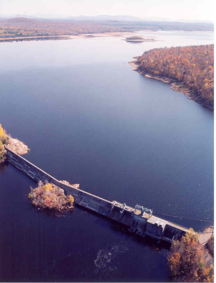
上拉奎特河計畫位於紐約州聖勞倫斯縣的拉奎特河上。拉奎特河口總流域面積為 1,269 平方英里,發源於阿迪朗達克高地的藍山湖、拉奎特湖和長湖。這條河大致向北偏西北流動,流經紐約州波茨坦,全長超過 146 英里,最後流入紐約州馬塞納附近的聖勞倫斯河。從歷史上看,這條河一直被開發用於鋸木廠、造紙廠、製革廠和其他工業的水力發電。
此計畫由六個開發案組成:Carry Falls(FERC 編號 2060)、Stark Falls、Blake Falls、Rainbow Falls、Five Falls 和 South Colton(統稱為 FERC 編號 2084)。拉奎特河上共有 19 個水力發電項目,包括 皮爾斯菲爾德 (LIHI #156) 位於上游,下游有數個,包括 中拉奎特 (LIHI # 14B), 下拉奎特 (LIHI #14C), 和 耶魯維爾 (LIHI #157) 位於 Lower Raquette 項目的兩個開發項目之間。
該項目最初於 1952 年至 1957 年建造並投入運營,歷時五年,包括六個開發項目:
- Carry Falls:存儲 壩 長 826 英尺,最大高度 76 英尺,混凝土重力 溢洪道 以及一條 258 英尺長、63 英尺高的混凝土閘門無溢流溢洪道。非溢流部分包括兩個 14.5 英尺 x 27 英尺的 Tainter 蓋茲、兩個 10 英尺 x 10 英尺的低位水閘,以及一個帶有兩個 15 英尺 x 15 英尺開口的進水口結構。共有五道土堤,總長 2,500 英尺,高度從 12 至 31 英尺不等。大壩形成了一個長 7 英里、面積 3,000 英畝的水庫。該開發案不涉及水力發電。
- 史塔克瀑布:大壩是一座 35 英尺高的混凝土重力結構,有 294 英尺長的混凝土 弧形 溢洪道段和控制閘段兩側有土堤。共有七座土堤,總長約 3,700 英尺,一座帶有 1 英寸淨距攔污柵的進水口,一座 651 英尺長、直徑 18 英尺的焊接鋼 壓力水管,和一個 發電站 包含一個 23.87 MW 垂直 混流式水輪機/發電單元。大壩攔蓄了一條長 1.5 英里、面積 641 英畝的水庫,形成了一條長 1.5 英里的繞河段。
- 布萊克瀑布:大壩為混凝土重力式結構,高 60 英尺(最大),帶有 592 英尺長的混凝土拱形溢流段。其他工程工程包括三座總長約 1,840 英尺的土堤、一個帶有 1 英寸淨距攔污柵的進水口、一個長 731 英尺、直徑 18 英尺的焊接鋼製壓力水管,以及一個包含一台 13.91 MW 垂直弗朗西斯式水輪機/發電機組的發電站。大壩攔蓄了一條 5.5 英里長、660 英畝的水庫,形成了一條 0.85 英里長的繞河段。
- 彩虹瀑布:大壩為混凝土重力式結構,最高 81.5 英尺,其混凝土拱形溢流段長 751 英尺,北側為 1,600 英尺長的土堤,南側為 100 英尺長的土堤。專案的其他工程包括一個帶有 1 英寸淨距攔污柵的進水口、一個 645 英尺長、18 英尺直徑的焊接鋼製壓力水管,以及一個包含一台 22.83 MW 垂直弗朗西斯式渦輪機/發電機組的發電站。大壩攔蓄了一條長 3.5 英里、面積 710 英畝的水庫,形成了一條長約 100 英尺的繞行河段。
- 五瀑布:大壩為混凝土重力式結構,高 50 英尺(最大),帶有 500 英尺長的混凝土拱形溢流段,兩端各有土堤。南堤長約 290 英尺,北堤長約 685 英尺。該設施有一個帶有 1 英寸淨距攔污柵的進水口、一個 1,399 英尺長、18 英尺直徑的焊接鋼製壓力水管(帶調壓室)以及一個包含一台 22.83 MW 垂直弗朗西斯式水輪機/發電機組的發電站。大壩攔蓄了一條長 1.0 英里、面積 120 英畝的水庫,形成了一條長 0.54 英里的繞道河段。
- 南科爾頓:大壩為混凝土重力式結構,高 42 英尺(最大),配有 592 英尺長的混凝土拱形溢流段和土製橋台。其他專案工程包括帶有 1 英寸淨距攔污柵的進水口、一個 1,220 英尺長、18 英尺直徑的焊接鋼製壓力水管(帶有調壓室)以及一個包含單個 18.95 MW 垂直弗朗西斯式渦輪機/發電機組的發電站。大壩攔蓄了一條長 1.5 英里、面積 225 英畝的水庫,形成了一條長約 0.4 英里的繞道河段。
該計畫與業主在拉奎特河上的其他開發案協調運作,包括中拉奎特河和下拉奎特河計畫。每個開發項目都以脈衝模式運作。正常流量條件下,水庫每日最大波動限值在斯塔克瀑布、布萊克瀑布和彩虹瀑佈為 1 英尺,在五瀑布和南科爾頓為 2 英尺。最小流量是透過德爾菲流量研究開發的,並在所有開發中提供:
- 卡里瀑布:在引導曲線下運行,提供足夠的流量來運行下游工廠並維持其最低流量,並確保雷蒙德維爾開發區(下拉奎特河項目的一部分)下游的流量和拉奎特河流入聖勞倫斯河之前的最後一個水庫的流量足以讓大多數淺灘棲息地隨時得到充分澆灌。
- 斯塔克瀑布:全年通過 停止日誌 大壩的一部分。如果水流通過 Tainter 閘門的時間達到或超過 24 小時,則釋放量將增加至 90 立方英尺/秒,直到 Tainter 閘門關閉後的 24 小時內。
- 布萊克瀑布:通過大壩的擋水板部分,全年釋放 55 立方英尺/秒的水量,從梭魚產卵季節開始到六月底,釋放量將增加到 120 立方英尺/秒。
- 彩虹瀑布:透過水壩的擋水板部分,全年釋放 20 立方英尺/秒的水量。
- 五瀑布:通過大壩的擋水板部分,全年釋放 50 立方英尺/秒的水量,在梭魚產卵季節,釋放量會增加到 145 立方英尺/秒。
- 南科爾頓:瀑布可見部分全年釋放 20 立方英尺/秒的水量。
計畫範圍內的水域被劃分為 B 類(Carry Falls)、C 類鱒魚水域和 D 類溫水漁場。 B 類水域最適合用於主要接觸娛樂和水生生物支援。 C 級鱒魚水域適合釣魚, 二次接觸娛樂。 D 類水域最適合用於二次接觸娛樂。計畫河段內沒有受損水域,水質整體上遠高於紐約州 B 類水域的最低標準,能夠支持多樣化、健康的冷水水生生物群落
此計畫河段遠高於歷史上游範圍,沒有洄游魚類物種。 溯河洄游魚類 遷徙。下游下拉奎特河計畫已為 洄游性 美洲鰻,但資源機構尚未在該計畫規定採取此類措施,儘管保留在未來必要時要求通過的權力。下游 魚道 是透過上述大壩中的最小流量結構提供的。每個開發項目都安裝了間距為 1 英吋的垃圾架,以最大限度地減少 夾帶 潛在的。
工程用地大部分位於阿迪朗達克公園內。因此,該地區人口稀少,大部分地區都是森林和灌木叢,開發程度很低。專案業主剝離了流域內和與專案相關的 12,000 英畝土地,但剝離範圍超出了專案邊界。
PLUS-標準型: 計畫業主自願與紐約州環境保護部合作,制定與毗鄰的州財產一致的土地使用實踐,並為項目土地制定土地使用管理計劃,以管理先前開發的海岸線並保護未開發的財產。此外,業主還設立並資助了拉奎特河拉奎特河諮詢委員會基金,以支持管理計畫活動。
計畫附近可能存在的受威脅或瀕危物種包括北長耳蝠、白頭鷹、雲杉松雞和北方叢生莎草。該計畫在卡里瀑布 (Carry Falls) 附近的白頭鷹築巢地點設立了標誌牌,詳細說明了白頭鷹的存在,以阻止船隻對該物種造成不利影響。白頭鷹保護和管理計畫包括對計畫區域內紐約州環境保護部白頭鷹觀察情況進行年度報告的規定。
根據與紐約州歷史保護辦公室的協商,計畫區域內不存在任何歷史或文化財產。我們制定了歷史財產管理計劃,以便在發現任何財產並提交任何地面擾動活動年度報告時提供指導。
該項目免費向公眾開放,其娛樂資源包括:
- 卡里瀑布:約旦河獨木舟搬運,卡里瀑布 壩 獨木舟搬運、帕門特露營地從陣亡將士紀念日週末到勞動節週末季節性開放(收費),但一直免費開放到感恩節。其他設施包括可拖車進入的船隻下水處和日間使用區。
- 史塔克瀑布:獨木舟搬運
- 布萊克瀑布:獨木舟搬運與死亡溪通道
- 彩虹瀑布:獨木舟搬運與白山野生森林步道
- 五瀑布:獨木舟搬運
- 南科爾頓:獨木舟搬運
合規狀態
目前證書不包括任何針對設施的特定條件。
2025: 未發現重大變更或合規問題。根據年度審查,該項目仍符合規定。
2024: 未發現重大變更或合規問題。根據年度審查,該項目仍符合規定。
2023: 未發現重大變更或合規問題。根據年度審查,該項目仍符合規定。
認證歷史
2023年1月3日: 2022 年 12 月 28 日上訴期結束後,在無人提出上訴的情況下,對上拉奎特河計畫進行認證的決定成為最終決定。認證期限為2022年7月9日至2035年7月8日。
2022年11月28日: 低影響水力發電研究所 (LIHI) 已初步批准上拉奎特河計畫獲得為期 13 年的新一輪低影響認證。完整的申請和審核報告如下。該決定是初步決定,需等待 30 天的上訴期。只有在 60 天的評論期內對初始申請發表評論的人才有資格提出上訴。此類上訴需要包括有關該項目如何不符合 LIHI 標準的解釋。申訴請求可以透過電子郵件發送至 comments@lowimpacthydro.org 請於主旨欄註明“Upper Raquette River Project”,或郵寄至 Low Impact Hydropower Institute, 1167 Massachusetts Ave, Arlington, MA 02476。所有請求都將發佈在網站上。申請人將有機會回應,任何回應也將被公佈。 申請必須在 2022 年 12 月 28 日美國東部時間下午 5 點前收到。如果沒有收到上訴請求且決定成為最終決定,則該計畫的認證期限為 2022 年 7 月 9 日至 2035 年 7 月 8 日。
2015年5月15日: 上拉奎特河水力發電計畫已獲得第三期低影響認證,有效期限為 2014 年 7 月 9 日,有效期至 2022 年 7 月 9 日。在頒發此認證時,研究所執行董事行使了 LIHI 理事會授予的權力,並全面審查了申請審查員的報告(可在下面的文件部分找到)以及申請人提供的所有公眾意見和其他資料。
- 2015年部分滿足,2021年完全滿足。 條件一: 在重新認證後90天內,拉奎特河上游水力發電計畫的業主應向 LIHI 提供所有水壩現有魚類通道和防護措施(例如鰻魚梯和1英寸間距的柵欄)的最新描述,以及新措施的安裝時間表。此外,還應向 LIHI 提交年度狀態報告以及年度合規聲明,其中描述過去一年的新設施以及魚類通道設施運作的任何變更。如果發生任何延誤或以其他方式影響 LIHI 的事件, 魚道 營運情況,應在年度狀況報告中說明。
2014年5月12日: 低影響水電研究所收到了拉奎特河計畫第三期認證申請。現行證書期限原定於 2014 年 7 月 9 日到期,但為了留出時間進行公眾評論和內部審查,證書期限已延長至 2014 年 8 月 30 日。
2010年4月15日: 拉奎特河計畫已被認證為低影響項目,第二個五年期限從 2009 年 7 月 9 日生效,到 2014 年 7 月 9 日到期。
2004年10月27日: 拉奎特河計畫已被認證為低影響項目,有效期為五年,自 2004 年 7 月 9 日生效,至 2009 年 7 月 9 日到期。
認證文件
2022 年重新認證
2014年重新認證
- 2014年Upper Raquette再認證審查報告
- 2014年Upper Raquette重新認證申請
- John Omohundro 評論信 – Upper Raquette 重新認證
- 美國魚類和野生動物管理局意見函 – Upper Raquette 重新認證