Certificat LIHI #157 – Projet Yaleville, New York
| Nom du projet | Yaleville |
| Numéro de certificat LIHI |
157 |
| Durée du certificat LIHI |
26 avril 2019 – 25 avril 2029 |
| Propriétaire | Erie Boulevard Hydropower, LP, une filiale de Brookfield Renewable Energy Group |
| État | New York |
| Emplacement | Mile 25,5 sur la rivière Raquette |
| Capacité installée | 0,7 MW |
| Génération annuelle moyenne | 3 800 MWh |
| Type d'établissement | Au fil de l'eau |
| Fédération internationale de radio-télévision (FERC) Non. | P-9222 délivré en 1992, expire le 31/12/2033 |
Le projet Yaleville est situé sur la rivière Raquette, près de la ville de Yaleville, dans les comtés de Franklin et de St. Lawrence, dans l'État de New York. Construit à l'origine en 1903 dans le seul but de produire de l'électricité, il a subi plusieurs améliorations au cours des années 1900, notamment l'installation d'une nouvelle structure en béton. buse en 1919; un béton barrage remplacé le barrage en rondins et les roues hydrauliques ont été remplacées par l'équipement hydroélectrique actuel ; un nouveau centrale a été construit en 1922 ; le bassin d'admission a été construit et le plancher de la salle des turbines a été recouvert en 1977 ; déversoir et canal les murs ont été reconstruits en 1978 ; le canal de fuite journal d'arrêt La structure et le canal de fuite ont été réparés en 1982, et des réparations du béton ont été effectuées sur les installations d'assèchement. Ces améliorations ont culminé en 1987 avec l'installation de nouvelles tête portes et un cadre de levage de porte de tête à l'entrée du projet.
La rivière Raquette possède un bassin versant total de 3 200 kilomètres carrés à son embouchure et prend sa source dans les hautes terres des Adirondacks, aux lacs Blue Mountain, Raquette et Long. Elle coule généralement en direction nord-nord-ouest sur plus de 235 kilomètres, traverse Potsdam (État de New York) et se jette dans le fleuve Saint-Laurent, près de Massena (État de New York).
Au total, 19 projets hydroélectriques existent sur la rivière Raquette, dont la plupart appartiennent au propriétaire du projet, y compris de l'amont à l'aval, Piercefield (LIHI #156), Raquette supérieure (LIHI #14A), Raquette centrale (LIHI #14B), et Raquette inférieure (LIHI #14C)Le projet Yaleville se situe entre les développements de Norwood et d'East Norfolk du projet Lower Raquette River.
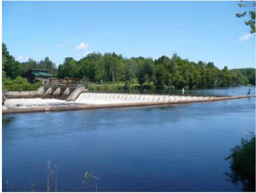
Le projet comprend un barrage, une structure de vanne de décharge, un tronçon contourné, une structure d'admission, un bassin d'admission, une centrale électrique et deux unités de production.
Le barrage est un barrage-poids en béton d'environ 170 pieds de long et 13 pieds de haut, avec une hauteur de 1,5 pied. tableaux d'affichage Au sommet, une structure de vanne gravitaire en béton de 23 mètres de long est composée de quatre travées de poteaux de 4,5 mètres de long et 3 mètres de haut. Chaque travée de poteaux est soutenue par une poutre en I centrale, créant deux travées de 2,3 mètres, soit un total de 8 travées. Chaque travée individuelle est dotée de poutrelles horizontales en bois de 3 mètres surmontées d'une vanne coulissante en acier de 1,5 mètre de haut. Un tronçon contourné d'environ 148 mètres de long est créé par le barrage. L'eau est acheminée vers la prise d'eau par un bief d'admission (canal) de 18 mètres de large et 84 mètres de long. La structure de prise d'eau fait partie intégrante du côté amont de la centrale. La centrale comprend deux unités Francis verticales d'une capacité combinée de 0,725 MW.
Le projet est exploité dans un au fil de l'eau mode et retient un réservoir de 95 acres qui s'étend sur environ 1,8 miles en amont. Passe à poissons les débits sont maintenus à 36 pi3/s après le ruissellement printanier et les panneaux de retenue sont réinstallés (vers le 15 mai de chaque année) jusqu'au 1er novembre. Mise en fourrière Les fluctuations sont surveillées par le maître d'ouvrage et des ajustements opérationnels sont apportés pour garantir le respect du régime fluvial. Ce régime d'écoulement a été élaboré sur recommandation du Service américain de la pêche et de la faune sauvage (USFWS) afin de préserver un habitat aquatique propice aux espèces de poissons résidentes. Le Département de la conservation de l'environnement de l'État de New York (NYSDEC) gère la rivière Raquette comme une ressource halieutique mixte d'eaux chaudes et froides.
Les eaux du tronçon du projet sont désignées comme étant de classe B, gérées pour un habitat aquatique de haute qualité et des ressources primaires et loisirs de contact secondaireLe tronçon du projet est également classé comme altéré par les agents pathogènes et présente de faibles concentrations en oxygène dissous. Cette altération est due à la mauvaise gestion des stations d'épuration des eaux usées des municipalités voisines. De faibles concentrations en oxygène dissous sont observées dans la rivière depuis les années 1940, mais elles s'améliorent régulièrement. La capacité hydraulique des turbines du projet permet fréquemment des débits de déversoir qui contribuent à l'aération des eaux s'écoulant en aval.
Le NYSDEC gère la rivière Raquette comme une pêche mixte d'eaux chaudes et froides. La population de poissons est composée de poissons de pêche sportive et de poissons de fond, notamment le doré jaune, l'achigan à petite bouche, le grand brochet, la perchaude, le crapet de roche, le crapet-soleil et la barbotte brune. Des données historiques indiquent poisson anadrome Aucune présence n'a été constatée dans les environs du projet. Parmi les espèces migratrices présentes dans la zone du projet, on compte l'anguille d'Amérique. Une zone en amont échelle à anguilles Fonctionne entre le 15 juin et le 15 septembre, conformément aux recommandations de l'USFWS et du NYSDEC. De plus, un déversoir rectangulaire est installé en aval. passe à poissons est exploité à partir du 15 mai (après le ruissellement printanier et tableau flash installation) jusqu'au 1er novembre. La passe à poissons déverse 36 pi3/s dans une eau de 3 pieds de profondeur piscine de plongéeLes poubelles espacées de 1 pouce atténuent entraînement des espèces résidentes.
Le terrain du projet s'étend sur environ 14 acres. Les terres environnantes sont principalement rurales, agricoles et forestières. Le littoral est principalement constitué de zones arbustives et aucune terre de valeur écologique significative n'est présente dans la zone du projet. L'exploitation au fil de l'eau du projet contribue à minimiser les fluctuations des retenues et donc à réduire le risque d'érosion du littoral.
Parmi les espèces menacées ou en voie de disparition potentiellement présentes à proximité du projet figurent le chausson à longues oreilles et le méné d'herbe. Aucun habitat essentiel n'est situé dans la zone du projet, et celui-ci est soumis à la règle 4(d) de l'USFWS concernant la protection du chausson à longues oreilles. Cette règle concerne principalement l'abattage d'arbres, habitat potentiel de cette espèce, du 1er juin au 31 juillet. Le méné d'herbe, une petite espèce de vairon, a été observé en amont du projet et constitue une espèce préoccupante pour la conservation de l'État.
Aucune ressource historique ou culturelle connue n'existe dans la zone du projet. Un pont à poutres métalliques a été construit en aval du projet en 1892 et pourrait être inscrit au patrimoine mondial. Registre national des lieux historiques. La consultation avec le Bureau de préservation historique de l'État (SHPO) a conclu que le projet n'aurait aucun impact sur la ressource et n'a recommandé aucune mesure pour sa protection. Cependant, le pont ne fait pas partie du projet. Une consultation plus approfondie avec le SHPO est nécessaire si le projet prévoit des travaux de construction ou des travaux de perturbation du sol.
Les ressources récréatives du projet comprennent un parcours de portage en canot avec aire de pique-nique, stationnement, signalisation et points de mise à l'eau en amont et en aval. L'accès public est gratuit, dans les limites de sécurité.
État de conformité
Il n'existe aucune condition spécifique à l'établissement dans le certificat actuel
2025: Aucun changement important ni problème de conformité n'a été identifié. Le projet demeure conforme suite à l'examen annuel. Un écart mineur et de courte durée concernant la retenue des eaux a été signalé, non considéré comme une violation des règles de la FERC.
2024: Aucun changement important ni problème de conformité n'a été identifié. Le projet demeure conforme suite à l'examen annuel. Le projet a modifié le bassin de plongée du passage des anguilles en aval en 2023 et prévoit des réparations du passage des anguilles en amont suite à une inspection de l'USFWS. Le projet a signalé deux écarts de débit mineurs et à court terme, dont l'un a été considéré comme une infraction à la FERC.
2023: Aucun changement important ni problème de conformité n'a été identifié. Le projet demeure conforme suite à l'examen annuel. Le projet modifiera le bassin de plongée du passage des anguilles en aval en 2023, suite à une inspection de l'USFWS.
2022: Aucun changement important ni problème de conformité n'ont été identifiés. Le projet reste conforme sur la base de l'examen annuel.
2021: Aucun changement ni problème de conformité n'a été signalé. Le projet reste conforme sur la base de l'examen annuel.
2020: Aucun changement ni problème de conformité n'a été signalé. Le projet reste conforme sur la base de l'examen annuel.
2019: Le rapport annuel pour le certificat actuel n’est pas encore entré en vigueur.
Historique des certifications
1er janvier 2022 : La durée du certificat LIHI a été prolongée conformément à la révision 2.05 du manuel de certification LIHI 2e édition publié le 1er janvier 2022. Reportez-vous au tableau des établissements ci-dessus pour connaître la nouvelle durée.
13 août 2019 : La décision de certifier le projet hydroélectrique de Yaleville est définitive. Aucun appel n'a été reçu pendant la période d'appel, clôturée le 9 août 2019. La nouvelle période de certification du projet s'étend du 26 avril 2019 au 25 avril 2024.
10 juillet 2019 : Le Low Impact Hydropower Institute a approuvé de manière préliminaire la certification à faible impact pour le projet hydroélectrique de Yaleville.
Cette décision est préliminaire en attendant la période d'appel de 30 jours. Seuls ceux qui ont commenté la demande initiale pendant la période de commentaires de 60 jours sont éligibles pour déposer un appel. Un tel appel doit inclure une explication sur la raison pour laquelle le projet ne répond pas aux critères du LIHI. Les demandes d'appel peuvent être soumises par courrier électronique à comments@lowimpacthydro.org avec « Projet hydroélectrique de Yaleville » en objet, ou par courrier adressé au Low Impact Hydropower Institute, 329 Massachusetts Ave, Suite 6, Lexington, MA 02420. Toutes les demandes seront publiées sur le site web. Le demandeur aura la possibilité de répondre, et toute réponse sera également publiée. Les demandes doivent être reçues avant 17 h, heure de l’Est, le 9 août 2019. Le dossier complet et le rapport des évaluateurs sont disponibles ci-dessous.
Si aucune demande d'appel n'est reçue et que la décision devient définitive, la période de certification du projet (en attente de LIHI #157) sera le 26 avril 2019 pour une durée de cinq (5) ans, qui expirera le 25 avril 2024.
1er mai 2019 : Le Low Impact Hydropower Institute a reçu une demande complète de certification à faible impact pour le projet hydroélectrique de Yaleville. Le LIHI sollicite les commentaires du public sur cette demande. Plus précisément, nous souhaitons savoir si, selon vous, le projet répond aux critères de certification à faible impact du LIHI, tels que révisés dans la 2e édition du manuel. Veuillez consulter le programme et les critères dans la version révisée du LIHI. Manuel et consultez ensuite les documents de candidature du projet ci-dessous.
Commentaires directement liés à des critères spécifiques du LIHI (débits, qualité de l'eau, passage des poissons, etc.) seront très utiles, mais tous les commentaires seront pris en compte. Les commentaires peuvent être soumis à l'Institut par courrier électronique à l'adresse comments@lowimpacthydro.org avec « Commentaires sur le projet Yaleville » dans l'objet, ou par courrier adressé au Low Impact Hydropower Institute, 329 Massachusetts Avenue, Suite 6, Lexington, MA 02420. Les commentaires doivent être reçus au plus tard à 17 h, heure de l'Est, le 30 juin 2019. à prendre en considération. Tous les commentaires seront publiés sur le site Web et le candidat aura la possibilité d'y répondre. Toute réponse sera également publiée.