Projets Hailesboro n° 3, 4 et 6 : Demande complète reçue
4 mai 2023 : Le Low Impact Hydropower Institute a approuvé la certification « faible impact » pour les projets hydroélectriques Hailesboro n° 3, n° 4 et n° 6. Le dossier complet et le rapport d'évaluation sont disponibles ci-dessous.
Cette décision est préliminaire, dans l'attente d'un délai d'appel de 30 jours. Seuls les candidats ayant commenté les demandes initiales pendant ce délai de 60 jours sont autorisés à déposer un recours. Ce recours doit inclure une explication expliquant en quoi les projets ne répondent pas aux critères du LIHI. Les demandes de recours peuvent être soumises par courriel à l'adresse suivante : comments@lowimpacthydro.org avec « Projets Hailesboro » dans l'objet, ou par courrier adressé au Low Impact Hydropower Institute, 1167 Massachusetts Ave, Arlington, MA 02476. Toutes les demandes seront publiées sur le site web. Le demandeur aura la possibilité de répondre, et toute réponse sera également publiée. Les demandes doivent être reçues avant 17 heures, heure de l’Est, le 3 juin 2023.
Si aucune demande d’appel n’est reçue, les délais de certification seront du 3 février 2023 au 2 février 2033.
7 février 2023 : Le Low Impact Hydropower Institute a reçu une demande complète de certification à faible impact pour le projet hydroélectrique Hailesboro n° 3, 4 et 6. Le LIHI sollicite les commentaires du public sur cette demande. Plus précisément, nous souhaitons savoir si vous pensez que le projet répond aux critères de certification à faible impact du LIHI, tels que révisés dans le manuel de 2e édition. Veuillez consulter le programme et les critères dans le manuel révisé du LIHI Manuel et consultez ensuite les documents de candidature du projet ci-dessous.
Les commentaires directement liés à des critères spécifiques du LIHI (débits, qualité de l'eau, passage des poissons, etc.) seront les plus utiles, mais tous les commentaires seront pris en compte. Les commentaires peuvent être envoyés à l'Institut par courrier électronique à l'adresse comments@lowimpacthydro.org avec « Hailesboro 3, 4, & 6 Project Comments » dans la ligne d'objet, ou par courrier adressé au Low Impact Hydropower Institute, 1167 Massachusetts Avenue, Arlington, MA 02476. Les commentaires doivent être reçus au plus tard à 17 heures, heure de l'Est, le 8 avril 2023. à prendre en considération. Tous les commentaires seront publiés sur le site Web et le candidat aura la possibilité d'y répondre. Toute réponse sera également publiée.
| Nom du projet | Hailesboro n° 3, 4 et 6 |
| Numéro de certificat LIHI |
En attente # 197, 198, 199 |
| Durée du certificat LIHI |
3 février 2023 – 2 février 2033 |
| Propriétaire | Acquisition du groupe de développement hydroélectrique, LLC
une filiale de Patriot Hydro. LLC |
| État | New York |
| Emplacement | N° 3 – Mile 67,5, N° 4 – Mile 67,7, N° 6 – Mile 68 sur la rivière Oswegatchie, comté de St. Lawrence, New York |
| Capacité installée | N° 3 : 1 MW
N° 4 : 1,9 MW N° 6 : 0,9 MW |
| Génération annuelle moyenne | N° 3 : 3 993 MWh
N° 4 : 10 647 MWh N° 6 : 4 728 MWh |
| Type d'établissement | Au fil de l'eau |
| Fédération internationale de radio-télévision (FERC) Non. | N° 3 : P-5633. Exemption publié le 14 juillet 1982, modifié le 11 juin 1998.
N° 4 : P-6058. Publié le 30 octobre 2002, expirant le 31 décembre 2032. N° 6 : P-3181. Exemption délivrée le 17 septembre 1981. |
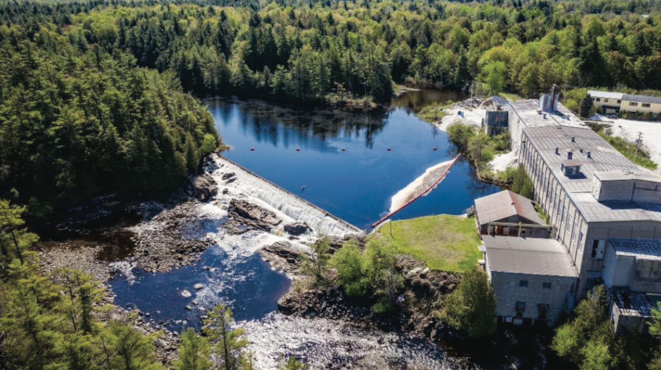
Les projets hydroélectriques Hailesboro n° 6 (FERC n° 3181), Hailesboro n° 4 (FERC n° 6058) et Hailesboro n° 3 (FERC n° 5633), collectivement appelés « projets Hailesboro », sont situés sur la rivière Oswegatchie, dans le comté de Saint-Laurent, dans l'État de New York. Ils sont détenus et exploités par Hydro Development Group Acquisition, LLC (HDGA). La rivière Oswegatchie, longue de 212 km, est située dans le bassin hydrographique du fleuve Saint-Laurent.
Le projet Hailesboro n° 6 est le plus en amont des trois projets et est situé au mile fluvial (RM) 68,2. Le projet est exploité sous un exemption publié par la Commission fédérale de réglementation de l'énergie le 17 septembre 1981.
Le projet consiste en (1) un déversoir gravitaire en béton armé de 10 pieds de haut et de 150 pieds de long barrage avec une altitude de crête de 487 pieds Système national de référence verticale géodésique (NGVD); (2) un réservoir d'une superficie de 4 acres et d'une capacité de stockage négligeable à une altitude normale de 487 pieds NGVD ; (3) une structure d'admission de 40 pieds de large et 70 pieds de long avec portes et des grilles à déchets le long de la rive sud (gauche) ; (4) a centrale contenant deux turbines d'une puissance nominale de 800 chevaux et 500 chevaux, reliées à deux générateurs d'une puissance nominale de 550 kilowatts (kW) et 350 kW, respectivement, à une tête de 5,8 mètres et un débit de 2,73 mètres cubes par seconde (pi³/s) ; (5) un court canal de fuite ; (6) un appareillage électrique ; (7) une ligne de transport de 2,3 kilovolts (kV) de 23,8 mètres de long ; et (8) des installations annexes. La centrale Hailesboro n° 6 a une puissance installée de 900 kW et fonctionne dans un au fil de l'eau Mode (ROR). Le barrage crée un court tronçon contourné, d'environ 106 mètres de long.
Le projet Hailesboro n° 4 est situé à RM 67,7, à environ 0,5 mile en aval de Hailesboro n° 6. Le projet fonctionne sous une licence délivrée par la FERC le 30 octobre 2002, qui a été modifiée le 19 septembre 2012. Le projet consiste en (1) un barrage-poids en béton composé de : (i) le barrage #1 de 105 pieds de long et 14 pieds de haut surmonté d'un barrage pneumatique de 2 pieds de haut porte de crête; et (ii) le barrage #2 de 58 pieds de long et de 5 pieds de haut surmonté de poutres en bois de 2 pieds de haut tableaux d'affichage; (2) un réservoir d'une superficie de 2 acres et d'un volume de stockage brut de 20 acres-pieds à une élévation normale de la surface de l'eau de 461 pieds NGVD; (3) une structure d'admission fermée avec des grilles à déchets en acier qui ont un espacement libre de 1,75 pouce; (4) un bassin d'admission revêtu de béton de 170 pieds de long canal avec une vanne ; (5) une centrale en béton armé et maçonnerie de béton contenant deux unités de turbines de type Francis à double roue montées horizontalement ; une unité de production de 900 kW et une unité de production de 1 000 kW pour une capacité installée totale de 1 900 kW ; (6) une unité de production de 2,4/23 kV sous-station, et une ligne de transmission de 23 kV de 50 pieds de long ; (7) des installations annexes ; et (8) une ligne gravitaire en béton de 73 pieds de long sur 3 pieds de haut dérivation Le barrage (déversoir de la branche Island), surmonté de planches en bois de 30 cm de haut, est situé à l'entrée de la branche Island de la rivière Oswegatchie. Il est entaillé pour assurer un débit minimal de 30 pi³/s dans le tronçon contourné de 0,4 mile de long. Le projet fonctionne en mode ROR automatique grâce au contrôle du niveau du bassin. Un débit minimal de 30 pi³/s est assuré par une entaille dans le déversoir de la branche Island. Les débits minimaux en aval sont les suivants : Barrage Les débits des barrages #1 et #2 sont respectivement de 20 pi³/s et 8 pi³/s, avec ajustements saisonniers conformément au certificat de qualité de l'eau (CQE) du projet. Le canal de fuite se déverse directement dans le bassin d'amont du projet Hailesboro n° 3.
Le projet Hailesboro n° 3 est situé à RM 67,5, à environ 0,25 miles en aval de Hailesboro n° 4. Le projet fonctionne sous une exemption délivrée par la FERC le 14 juillet 1982, telle que modifiée par l'ordonnance de la FERC émise le 11 juin 1998.
Le projet consiste en (1) un barrage en béton armé de 16 pieds de haut et de 68 pieds de long ayant une longueur de 24 pieds déversoir section avec une altitude de crête de 427,2 pieds NGVD et ayant une section d'admission à gauche (sud) pilier et une section d'écluse fermée au niveau de la culée droite ; (2) un réservoir d'une superficie de 6,5 acres et d'une capacité de stockage négligeable à une altitude de surface normale de 427,2 pieds NGVD ; (3) une structure d'admission à vanne en bois, d'une longueur de 90 pieds et d'un diamètre de 9 pieds conduite forcée, une conduite forcée de 95 pieds de long et de 8,5 pieds de diamètre, et une boîte de prise d'eau en béton contenant deux turbines ; (4) une centrale électrique contenant deux groupes électrogènes de 500 kW ; (5) un canal de fuite ; (5) une sous-station ; (6) des installations annexes ; et (7) une ligne de transport de 2,3 kV de 0,25 mile de long. Le projet a une capacité installée de 1 000 kW et fonctionne en mode ROR tout en fournissant un débit minimum de 3 pi3/s dans le tronçon contourné d'environ 200 pieds de long.