LIHI 證書 #96 - 馬薩諸塞州紅橋項目
| 項目名稱 | 紅橋 |
| 理海證書編號 | 96 |
| LIHI 證書期限 |
2023年3月27日-2033年3月26日 |
| 擁有者 | Central Rivers Power MA, LLC,LS Power/Patriot Hydro, LLC 的子公司 |
| 狀態 | 麻薩諸塞州 |
| 地點 | 位於馬薩諸塞州漢普登縣和漢普郡縣的威爾布拉漢姆鎮、拉德洛鎮、帕爾默鎮和貝爾徹敦鎮,奇科皮河約 15.2 英里處。 |
| 裝置容量 | 4.5兆瓦 |
| 平均年發電量 | 12,715 兆瓦時 |
| 設施類型 | 河流的奔流 |
| 聯邦能源監管委員會 不。 | P-10676 豁免 1992 |
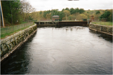
紅橋計畫位於麻薩諸塞州漢普登縣和漢普郡的威爾布拉漢姆鎮、拉德洛鎮、帕爾默鎮和貝爾徹敦鎮,位於奇科皮河畔。該專案 壩 穿過威爾布拉漢姆和拉德洛之間的城鎮邊界; 發電站 位於威爾布拉漢姆。蓄水池向東北延伸,與貝爾徹敦和帕爾默接壤。該項目最初由拉德洛製造公司於1901年建造。
奇科皮河雖然只有 18 英里長,但其流域面積卻達到 721 平方英里,是整個麻薩諸塞州最大的流域,也是康乃狄克河最大的支流流域。在工業革命期間,奇科皮河成為特別受歡迎的水力發電目的地,主要是因為其流經的河段落差為 260 英尺。
該項目是奇科皮河上六座大壩中最上游的一個。下游大壩是 柯林斯計畫(LIHI #88), 印度果園 (LIHI #112)、奇科皮瀑布(FERC 編號 6522)以及 德懷特 (LIHI #170).
該項目包括一座水壩, 運河 主門房,電力運河,兩個運行 壓力管道,一棟包含兩台發電機組的發電廠房、一條尾水渠及其附屬設施。大壩上游蓄水池東北岸設有兩座防洪堤。
大壩大致呈南北走向橫跨奇科皮河,由三段組成。大壩北段由一條165英尺長的土堤和混凝土心牆組成。大壩中段為一條300英尺長的溢流壩 溢洪道,由碎石和切割花崗岩面層構成。南段為362英尺長的土堤,有混凝土心牆。大壩最大高度約51英尺。切割石砌橋台將兩段土堤與中間的溢洪道段隔開。大壩形成了一個約2160英尺長的旁路河段。
運河閘門房是一座建在花崗岩地基上的木造建築,內有 10 個進水口 蓋茲 控制從蓄水池到電力渠道的水流。手動操作的 頭門 全部為鋼結構,寬 5.5 英尺,高 8.5 英尺。
電力管道從閘門延伸至 壓力水管 引水渠結構。該渠長約340英尺,寬73英尺,深13英尺。內側壁由切割花崗岩構成。傾斜的土堤構成外壁,渠底為混凝土。
這條運河通往水管進水口,進水口連接兩座運作中的水管和兩座廢棄的水管。進水口上游面的攔污柵旁,有一座鑿石冰閘,橫跨紅橋路下方,將水排回奇科皮河。閘門為鑄鐵,寬3英尺,高2英尺,由絲槓機構控制。兩座直徑13英尺、長100英尺的鋼製水管(可運轉)和兩座不可運轉的水管(不可運轉)從地下通往發電站。兩座不可運轉的水管於1938年停止使用。
發電站由磚塊和石材建造而成。最初約建於1901年的設備包括臥式水車和40轉發電機。 1號和2號機組的原水車於1938年退役。發電站北端設有已停產的1號和2號機組的蓄水井,南端設有正在運轉的3號和4號機組的蓄水井。該項目總裝置容量為4.5兆瓦。兩台運轉機組的流水經由兩個尾水渠排入尾水渠。尾水渠向南延伸735英尺,最終匯入奇科皮河。
防洪堤位於水庫東北岸附近,距離水壩上游約1500英尺。第一道防洪堤(稱為鐵路堤)為土築,底部寬約60英尺,長50英尺,高10英尺。第二道防洪堤(稱為奧爾登街堤)位於鐵路堤以北約650英尺,向東北延伸約
該項目運營於 徑流 模式並蓄水185英畝的水庫。 扣押 水位波動限制在+/- 0.25英尺以內。該專案在4月1日至6月30日提供最低237立方英尺/秒的旁路流量,其餘時間則提供100立方英尺/秒的旁路流量。此流量方案是與美國魚類及野生動物管理局以及麻薩諸塞州魚類及野生動物部門(MDFW)協商制定的,旨在保障水質並維護漁業棲地。
工程覆蓋範圍內的水域因入侵性水生植物而受到破壞。馬薩諸塞州環境保護部確認,該項目不應對這些破壞負責,但需進行確認性採樣。
奇科皮河流域目前尚未實施洄游魚類管理措施。美洲鰻是奇科皮河流域唯一的洄遊物種。下游水壩阻礙了洄游魚類的遷徙。 溯河洄游魚類 物種。除美洲鰻外,計畫區域不太可能發現洄遊物種。此外,該項目是在河流上建造第一批水壩之後很久才建造的,這些水壩可以追溯到19世紀末。雖然最低流量閘門並非專門為此設計的,但它允許河流魚類和鰻魚順流而下。
工程用地面積為4英畝,包括工程建築物、鄰近田地及一些林地。項目附近不存在具有重要生態價值的土地。如果計劃進行任何土地擾動/清理活動,則需要製定侵蝕控制計劃。
計畫附近可能存在的受威脅或瀕危物種包括北長耳蝠,它有可能在全州範圍內找到棲息地。與明尼蘇達州漁業和野生動物部 (MDFW) 的諮詢表明,所有項目區域均未被劃定為優先棲息地或預估棲息地,因此預計在項目區域內不會發現這種蝙蝠。
該項目被納入 國家歷史遺跡名錄 作為拉德洛村歷史街區的一部分。在進行任何擾動土地的活動或對項目歷史特徵進行任何修改之前,必須諮詢州歷史保護辦公室。
此計畫的休閒資源包括小船通道、野餐設施、健行步道以及位於發電站尾水渠下方的獨木舟下水處。這些設施目前由馬薩諸塞州自然保護與娛樂部和馬薩諸塞州漁業與野生動物部(MDFW)負責監督。民眾可免費使用。
合規狀態
此證書包括以下設施特定條件:
條件一: 設施所有者應在報告最終確定後60天內向 LIHI 提供即將進行的水質檢測結果報告副本,以及 USFWS 和 MDEP 收到的評論。目前,該報告計劃於 2024 年 11 月 30 日完成。如果本研究結果發現需要進行額外檢測或其他措施,則還應向 LIHI 提供實施這些措施的計劃和時間表。
條件2: 發電廠及相關維修工程完工並恢復營運後,設施業主應通知 LIHI。通知應包含因發電廠倒塌而對設施結構或營運造成的任何永久性變更的記錄。 LIHI 保留根據任何變更修改認證或條件的權利。
2026: 未發現任何實質變更或合規性問題。根據年度審查,該項目仍符合合規要求。該項目仍處於停駛狀態。對於條件1和條件2,該項目未報告任何變更。.
2025: 未發現任何重大變更或合規問題。根據年度審查,該項目仍然合規。該項目仍處於停駛狀態。對於條件1,該項目報告由於項目停駛而未進行任何研究。對於條件2,該項目報告了發電廠維修的狀況。
2024: 未發現任何重大變更或合規問題。根據年度審查,該項目仍然合規。 2023年8月22日,發電站部分倒塌,導致碎屑對環境造成輕微擾動,少量礦物油進入河流-該計畫當時並未運行,因此影響僅限於尾水。該項目目前仍處於停駛狀態。對於條件1,該計畫報告稱,由於發電站倒塌導致所有河流水流都流經旁路河段,因此未進行水質研究。 2023年夏季河流流量異常高,資源機構同意將研究延後至2024年。對於條件2,該項目報告稱,將繼續對設施和發電站進行評估。
2023: 目前證書的年度報告尚未生效。
認證歷史
2024 年 1 月 3 日: 低影響水力發電研究所已就紅橋、普茨橋、印第安果園和德懷特水力發電計畫中期重新認證發布了最終決定。這些項目位於馬薩諸塞州的奇科皮河上。初步決定於 2023 年 11 月 28 日宣布,並開啟為期 30 天的上訴期。該窗口於 2023 年 12 月 28 日關閉,並且沒有提出上訴。因此,重新認證專案的決定現已是最終決定。新項目期限如上表所示,完整的中期審查申請及審查報告如下。
2023 年 11 月 28 日: 低影響水力發電研究所已初步批准對位於麻薩諸塞州奇科皮河上的紅橋、普茨橋、印第安果園和德懷特計畫水力發電計畫進行低影響重新認證。該決定尚處於初步階段,需等待30天的申訴期結束。只有在60天的評論期內對初始申請發表意見的人員才有資格提出申訴。此類申訴需要說明為何該計畫不符合低影響水力發電研究所的標準。申訴請求可以透過電子郵件發送至 comments@lowimpacthydro.org 主題行為“Chicopee River Projects”,或郵寄至 Low Impact Hydropower Institute,地址為 1167 Massachusetts Ave, Arlington, MA 02476。申請人將有機會回應,任何回應也將公佈。 請求必須在 2023 年 12 月 28 日東部時間下午 5 點之前收到。 綜合審查報告如下。如無上訴請求,新的認證期限為2023年3月27日至2033年3月26日。
2023 年 8 月 17 日: 位於馬薩諸塞州奇科皮河上的四個 LIHI 認證項目於 2023 年 3 月 13 日收到了對其 FERC 豁免的合併修訂。這些項目分別是 Red Bridge (LIHI #96)、Putts Bridge (LIHI #102)、Indian Orchard (LIHI #112) 和 Dwight (LIHI #170)。該修正案授權對每個項目的運作進行變更 達到峰值 在一些項目中,隨著繞行河段最小流量的變化,河流將變為徑流。根據第二版 LIHI 手冊 2.05 修訂版第 5.3.4 節的規定,頒發 FERC 豁免 影響 LIHI 標準的修訂構成“重大變化”,並觸發中期 LIHI 認證審查。如果專案繼續符合 LIHI 標準,即使目前認證條款尚未到期,也可以授予新的認證條款。申請人 Central Rivers Power, MA, LLC(LS Power/Patriot Hydro, LLC 的子公司)已提交與 FERC 豁免修正案相關的營運變更摘要。各項目網頁的認證文件部分提供相關文件:
- 紅橋 – LIHI #96 – 請參閱下面的文件。
- 推桿橋 – LIHI #102
- 印度果園 – LIHI #112
- 德懷特 – LIHI #170
現開放為期 60 天的公眾意見徵詢期,供利害關係人就該提交文件發表意見。所有收到的意見將納入中期審查報告,並在 LIHI 網站上發布,並納入計畫重新認證的初步決定。意見可提交至 mailto:comments@lowimpacthydro.org 主題為「奇科皮河計畫」。 評論必須在 2023 年 10 月 16 日美國東部時間下午 5 點之前收到。
2022 年 1 月 1 日: 根據 2022 年 1 月 1 日發布的 LIHI 第二版認證手冊第 2.05 版,LIHI 證書期限已延長。
2018年12月18日: 紅橋水力發電計畫30天的申訴期現已結束,目前尚未收到任何申訴。因此,初步裁決現已生效,紅橋水力發電計畫的新一輪5年期限已獲批准,自2017年3月27日起生效,至2022年3月26日止。
2018年11月15日: 低影響水力發電研究所 (LIHI) 已初步批准紅橋水力發電計畫獲得為期 5 年的新一輪低影響認證。此決定尚待 30 天的申訴期過後才能做出。只有在 60 天的評論期內對初始申請發表意見的人員才有資格提出申訴。此類申訴需要說明為何該項目不符合 LIHI 的標準。申訴請求可以透過電子郵件發送至 comments@lowimpacthydro.org 請在郵件主旨中註明“紅橋水力發電計畫”,或郵寄至低影響水力發電研究所,地址:329 Massachusetts Ave, Suite 2, Lexington, MA 02420。所有申請都將發佈在網站上。申請人將有機會回复,回復也將發布。 請求必須在 2018 年 12 月 15 日美國東部時間下午 5 點之前收到。 完整的申請和審核報告如下。如果沒有收到申訴請求且該決定成為最終決定,紅橋計畫的認證期限將為2017年3月27日至2022年3月26日。
2018年8月7日: 低影響水力發電研究所已收到紅橋水力發電計畫 (LIHI # 96) 新一期低影響認證的完整申請。該項目位於馬薩諸塞州中部的奇科皮河畔。 LIHI 正在就此申請徵詢公眾意見。具體而言,我們想知道您是否認為該項目符合 LIHI 低影響認證標準(第二版手冊中修訂版)。請查看 LIHI 修訂版中的項目和標準。 手冊 然後查看下面該項目的2018年申請資料。與特定 LIHI 標準(流量、水質、 魚道等等)將非常有幫助,但所有評論都會被考慮。意見可以透過電子郵件提交給研究所 comments@lowimpacthydro.org 請在主題行中註明“紅橋計畫評論”,或郵寄至低影響水電研究所,地址:329 Massachusetts Avenue, Suite 2, Lexington, MA 02420。 評論必須在 2018 年 10 月 6 日美國東部時間下午 5 點之前送達研究所 予以考慮。所有評論都將發佈到網站上,申請人將有機會回應。任何回應也將被發布。
2018年6月14日: 紅橋水力發電工程已獲準延長現有證書期限。新的到期日為2018年11月30日。
2017年12月26日: 紅橋水力發電工程已獲準延長現有證書期限。新的到期日為2018年6月30日。
2017年3月1日: 紅橋水力發電工程已獲準延長現有證書期限。新的到期日為2017年11月30日。
2013年7月17日: 在 2013 年 6 月 25 日的會議上,低影響水力發電研究所管理委員會修改了紅橋計畫認證的條件 D。
2012年9月16日: 紅橋計畫已認證為低影響項目,有效期為五年,自 2012 年 3 月 27 日起生效,至 2017 年 3 月 27 日到期。
2012年3月27日: Essential Power LLC已提交紅橋專案認證申請。公眾意見徵詢期已開啟。
認證文件
2023年中期審查
2018 年重新認證
2012 年認證
- 紅橋認證審查報告
- 紅橋認證問卷
- 紅橋申請表及附錄
- 申請附錄 – 美國魚類和野生動物信函 2011
- 申請附錄 – 麻薩諸塞州環境保護部 2011
- 應用程式附錄 – 最小流量 2012年監測計劃
- 申請附錄 – 麻薩諸塞州歷史委員會信函 2011
- 申請附錄 – 2011 年北美能源聯盟信函
- 申請附錄 – FERC 信函 2011
- 申請附錄 – 麻薩諸塞州漁獵局信函 2011
- 斯萊特評論信 – 馬薩諸塞州漁獵局 2012