LIHI 證書 #20 - 紐約州 Salmon River 項目

| 項目名稱 | 薩蒙河 |
| 理海證書編號 | 20 |
| LIHI 證書期限 | 2021年11月14日 – 2034年11月13日 |
| 擁有者 | Erie Boulevard Hydropower, LP,布魯克菲爾德再生能源集團的子公司 |
| 狀態 | 紐約 |
| 地點 | 位於紐約州奧斯威戈市雷德菲爾德鎮和奧威爾鎮鮭魚河 13.8 英里和 18 英里處。 |
| 裝置容量 | 總計:36.25 兆瓦 貝內特橋:28.75 兆瓦 燈塔山:7.5兆瓦 |
| 平均年發電量 | 116,354 兆瓦時 |
| 設施類型 | 貝內特橋:季節性商店和發行,在 達到峰值 模式。 燈塔山:以重新調節模式運作的儲存和釋放。 |
| 聯邦能源監管委員會 不。 | P-11408 於 1996 年簽發,效期至 2036 年 1 月 31 日 |
薩蒙河計畫包括紐約州雷德菲爾德、奧威爾和奧斯威戈鎮薩蒙河沿岸的兩個開發案。薩蒙河位於該州中北部,流域面積為 285 平方英里,在奧斯威戈縣的安大略港流入安大略湖。該計畫的營運計畫是透過鮭魚河計畫和解協議 (SRPSO) 制定的,並與紐約州環境保護部 (NYSDEC)、紐約河流聯合會、阿迪朗達克山俱樂部和鱒魚無限公司協商。 SRPSO 旨在為專案的持續運作提供長期環境保護措施,並實現 Salmon 地區電力和非電力價值的平衡。 流域.
此項目包括兩個發展項目:
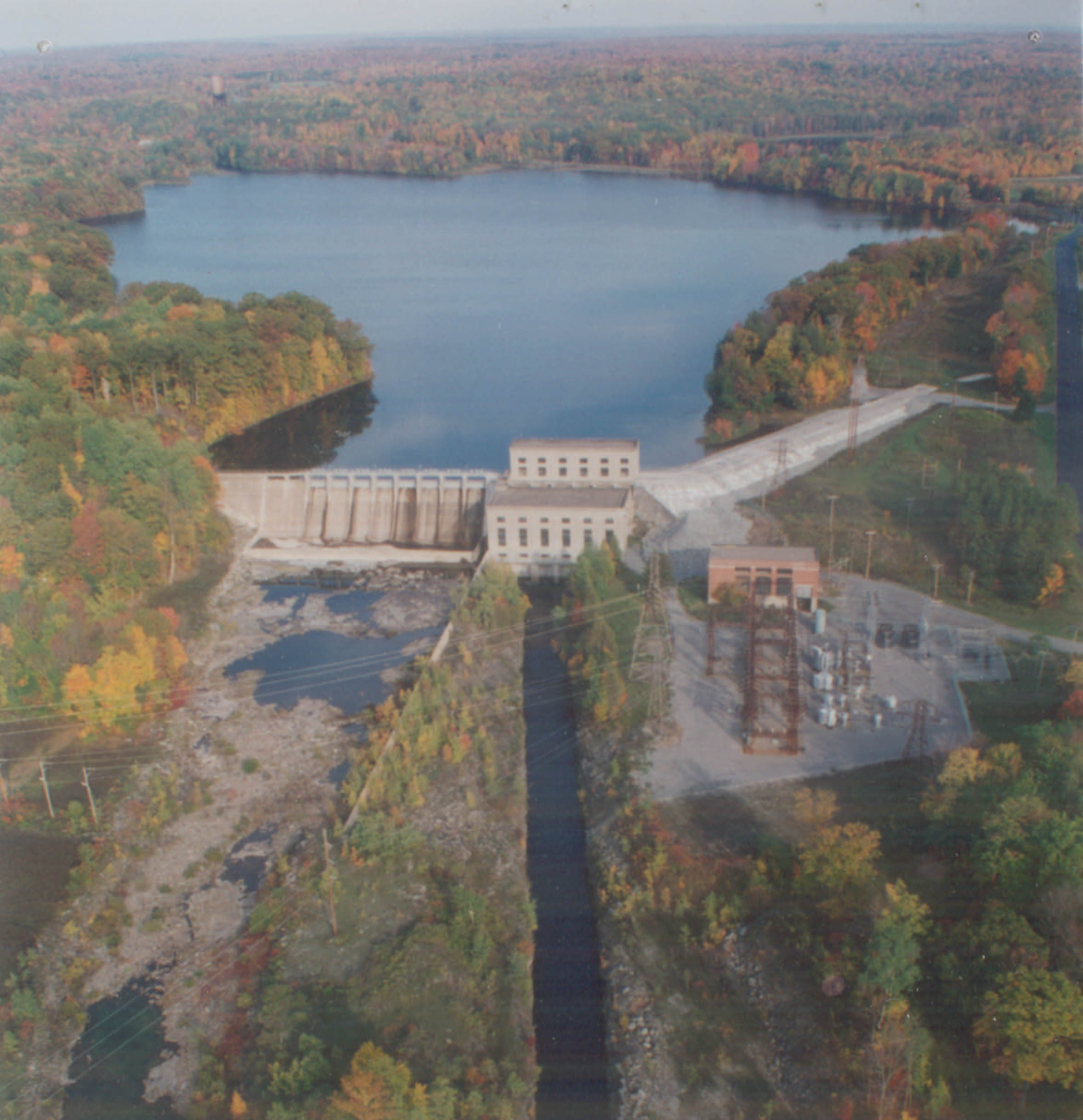
- 貝內特橋的發展: 壩 是一座 607 英尺長、45 英尺高的混凝土 重力壩 採用鋼筋混凝土進水口結構,長 92 英尺,寬 39.5 英尺,高 53 英尺。大壩由一段 107 英尺長的非溢流段、一段 244 英尺長的無閘門 溢洪道 部分配備2英尺高 閃光板,以及一個 256 英尺長的閘門溢洪道部分,其中有 11 個 11.5 英尺高、20 英尺寬的 Tainter 蓋茲。大壩蓄水庫最大水面面積為 3,550 英畝,形成一條 3.5 英哩長的繞行河段。水庫南岸有三道土堤,長分別為 100 英尺、1,330 英尺和 695 英尺。這個 10,000 英尺長的管道系統包括:一個 650 英尺長、直徑 12 英尺的混凝土隧道段;一段長 7,790 英尺、直徑 12 英尺的增強塑膠管道;一段長 1,200 英尺、直徑 11.5 英尺的鋼管管道;一個 105 英尺高的鋼調壓罐;一個長 200 英尺的鋼材分配器; 壓力管道,每個長 330 英尺,直徑 8 英尺,配有相關的關閉閥和空氣閥。這 發電站 由混凝土、磚和鋼製成,包含四個水平 混流式水輪機-發電機組總容量為28.75兆瓦。
- 燈塔山開發案:大壩為 382 英尺長的混凝土重力壩,由 155 英尺長、59 英尺高的非溢流段、43 英尺長、53 英尺高的無閘門溢洪道段(由 1 英尺高的擋水板控制)以及 184 英尺長、46 英尺高的溢水道段(由 1 英尺高的擋水板控制)以及 184 英尺長、46 英尺高的溢水口,大壩蓄水庫最大水面面積為 170 英畝,形成 0.57 英里長的繞行河段。土堤長 324 英尺,高 40 英尺。該開發案擁有三座寬 17 英尺、高 8 英尺、長 62 英尺的混凝土壓力水管和通往發電站的 15 英尺長的水閘部分。發電廠廠房為混凝土、磚石、鋼結構,設有進水口結構,內有兩台立式混流式水輪發電機組及一台環流式水輪發電機組。所有機組的總容量為 7.5 兆瓦。環境流發電機組運行,全年連續釋放 基流。尾水寬 40 英尺,長 2,800 英尺。
該項目在 Bennett's Bridge 開發區以峰值模式作為季節性儲存和釋放設施運行,並在 Lighthouse Hill 開發區以再調節模式作為儲存和釋放設施運行。流量由 SRPSO 決定,流量管理諮詢團隊負責評估可能影響河流流量並因此改變專案流量運作的變化條件。該團隊由紐約州環境保護署、美國魚類和野生動物管理局。
貝內特橋開發案為繞行河段提供了從 7 月 1 日到 9 月 30 日的持續最低流量 20 立方英尺/秒,其餘時間為 7 立方英尺/秒的流量,並根據流入量調整蓄水坡道限制。 Lighthouse Hill 開發案依照 規則曲線 保護和改善水資源、水質、漁業、美學資源和娛樂資源。該開發案為 Salmon River 魚孵化場直接提供了 22 立方英尺/秒的水流。
計畫範圍內的水域被指定為適合鱒魚養殖的冷水漁場。這些水域最適合捕魚和所有其他用途,除了作為飲用、烹飪或食品加工以及主要接觸娛樂的水源。該河段也被列為受損河段 多氯聯苯 以及被污染的沉積物中的滅蟻靈。紐約州環境保護部已確定該計畫不會造成或加劇這種損害。
該項目附近的魚類通道歷史上一直被位於貝內特橋下游約 1 英里處的 110 英尺高的天然 Salmon River 瀑布所阻擋。資源機構尚未規定該項目的任何通道設施。燈塔山和貝內特橋開發區均安裝了垃圾架,覆蓋層的間距分別為 1 英吋和 1.5 英吋。
計畫土地主要為紐約州擁有和管理的州立森林土地。工程蓄水池設有專用緩衝區,用於保護目的。
PLUS-標準型: 透過自願努力,計畫所有者與州政府合作制定與毗鄰的州財產一致的計畫土地使用實踐。與紐約州環境保護部共同製定了土地使用管理計劃 (LUMP),為海岸線提供管理條款並保護該地區未開發的財產。計畫所有者還設立並資助了 Salmon River 改善基金,以支持 LUMP 為 Salmon River 所做的努力。
計畫附近可能存在的受威脅或瀕危物種包括白頭鷹、斑嘴鸊鷉、北長耳蝠和印第安納蝙蝠。白頭鷹是該地區偶爾出現的過境物種,但不會受到計畫運作的影響。任何可能影響所列物種的活動,例如伐木,必須先獲得美國魚類及野生動物管理局的批准和諮詢。
該計畫的歷史資源包括貝內特橋發電站、大壩和調壓室。該專案已實施了歷史財產管理計劃,其中包括要求向國家歷史保護辦公室提交專案活動年度報告的規定。
此計畫的娛樂資源包括野餐區、釣魚通道、船坡道、露營區、解說標誌和遠足小徑。此外,專案所有者每年至少有五個週末開放白水划船活動。白水流量如下:六月的一個週末 - 400 立方英尺/秒;七月的兩個週末——750 立方英尺/秒;8 月的第一個完整週末——750 立方英尺/秒;九月的第一個週末為 750 立方英尺/秒。流量表可在 https://safewaters.com/facility/lighthouse-hill。公眾可以免費進入。
合規狀態
目前證書中沒有針對設施的特定條件。
2025: 未發現重大變更或合規問題。根據年度審查,該項目仍符合規定。
2024: 未發現重大變更或合規問題。根據年度審查,該項目仍符合規定。
2023: 未發現重大變更或合規問題。根據年度審查,該項目仍符合規定。
2022: 未發現重大變更或合規問題。根據年度審查,該項目仍符合規定。
2021: 目前證書的年度報告尚未生效。
認證歷史
2022年3月9日: 低影響水力發電研究所已就鮭魚河計畫的重新認證發布了最終決定。 30 天的上訴期限於 2022 年 2 月 19 日關閉,目前尚未收到任何上訴。因此,重新認證該專案的決定現已是最終決定。新期限為 2021 年 11 月 14 日至 2034 年 11 月 13 日,符合 LIHI 第二版認證手冊 2.05 修訂版中於 2022 年 1 月 1 日生效的期限延長。
2022 年 1 月 20 日: 低影響水力發電研究所 (LIHI) 已初步批准對 Salmon River 計畫進行為期 13 年的新一輪低影響認證。該決定是初步決定,需等待 30 天的上訴期。只有在 60 天的評論期內對初始申請發表評論的人才有資格提出上訴。此類上訴需要包括有關該項目如何不符合 LIHI 標準的解釋。申訴請求可以透過電子郵件發送至 comments@lowimpacthydro.org 主題行為“Salmon River Project”,或郵寄至 Low Impact Hydropower Institute,地址為 1167 Massachusetts Ave, Office 407, Arlington, MA 02476。申請人將有機會回應,任何回應也將公佈。 請求必須在 2022 年 2 月 19 日東部時間下午 5 點之前收到。 完整的申請和審核員報告如下。如果沒有收到上訴請求且決定成為最終決定,則該計畫的認證期限為 2021 年 11 月 14 日至 2034 年 11 月 13 日。
2021年10月27日: 低影響水力發電研究所 (LIHI) 已收到 Erie Boulevard Hydropower, LP 針對 Salmon River 計畫的完整重新認證申請。 LIHI 正在尋求對該申請的評論。與特定 LIHI 標準(流量、水質、 魚道等等)將非常有幫助,但所有評論都會被考慮。意見可以透過電子郵件提交給 LIHI,郵箱地址為 comments@lowimpacthydro.org 請在主旨欄註明“Salmon River 專案評論”,或郵寄至 Low Impact Hydropower Institute, 1167 Massachusetts Avenue, Office 407, Arlington, MA 02476。 意見必須在 2021 年 12 月 26 日美國東部時間下午 5 點前送達研究所,研究所才會考慮。 所有評論都將發佈到網站上,申請人將有機會回應。任何回應也會發布。完整的應用程式如下。
2014年12月8日: 執行董事 Michael J. Sale 已確定 Salmon River 水力發電計畫(FERC 編號 11408)、LIHI 證書編號 20 滿足低影響水力發電研究所 (LIHI) 認證計畫的要求。對 Salmon River 水力發電計畫的認證決定為 8 年,有效期為 2013 年 11 月 14 日,截止於 2021 年 11 月 14 日。
2013年11月18日: 伊利大道水電有限合夥公司 (Erie Boulevard Hydropower, LP) 已提交了對 Salmon River 專案進行重新認證的申請。由於行政積壓,現有證書的有效期限已從 2013 年 11 月 14 日的到期日延長三個月。
2006年3月28日: 薩蒙河水力發電計畫已被認證為低影響項目,有效期為八年,自 2005 年 11 月 14 日起生效,至 2013 年 11 月 14 日到期。
2005年11月14日: 已提交 Salmon River 水力發電計畫認證申請。