Certificat LIHI #156 – Projet Piercefield, New York
| Nom du projet | Piercefield |
| Numéro de certificat LIHI |
156 |
| Terme de certification LIHI |
26 avril 2019 – 25 avril 2029 |
| Propriétaire | Erie Boulevard Hydropower, LP, une filiale de Brookfield Renewable Energy Group |
| État | New York |
| Emplacement | Mile 88,5 sur la rivière Raquette |
| Capacité installée | 2,7 MW |
| Génération annuelle moyenne | 16 520 MWh |
| Type d'établissement | Modifié au fil de l'eau |
| Fédération internationale de radio-télévision (FERC) Non. | P-7387 délivré en 2005, expire le 31/10/2035 |
Le projet Piercefield est situé sur la rivière Raquette, près de la ville de Piercefield, dans les comtés de Franklin et de St. Lawrence, dans l'État de New York. Le projet barrage et centrale Construites en 1899 par l'International Paper Company pour alimenter le processus de fabrication du papier, les installations ont été transformées en centrale électrique en 1926. Plusieurs autres modifications ont été apportées au début du XXe siècle, puis dans les années 1970, pour remplacer les sections en bois des structures par des structures en béton plus robustes.
La rivière Raquette possède un bassin versant total de 3 200 kilomètres carrés à son embouchure et prend sa source dans les hautes terres des Adirondacks, aux lacs Blue Mountain, Raquette et Long. Elle coule généralement en direction nord-nord-ouest sur plus de 235 kilomètres, traverse Potsdam (État de New York) et se jette dans le fleuve Saint-Laurent, près de Massena (État de New York).
Au total, 19 projets hydroélectriques existent sur la rivière Raquette, dont la plupart appartiennent au propriétaire du projet, y compris de l'amont à l'aval, Yaleville (LIHI #157), Raquette supérieure (LIHI #14A), Raquette centrale (LIHI #14B), et Raquette inférieure (LIHI #14C)Le projet lui-même est le barrage le plus au sud et le plus en amont de la rivière.
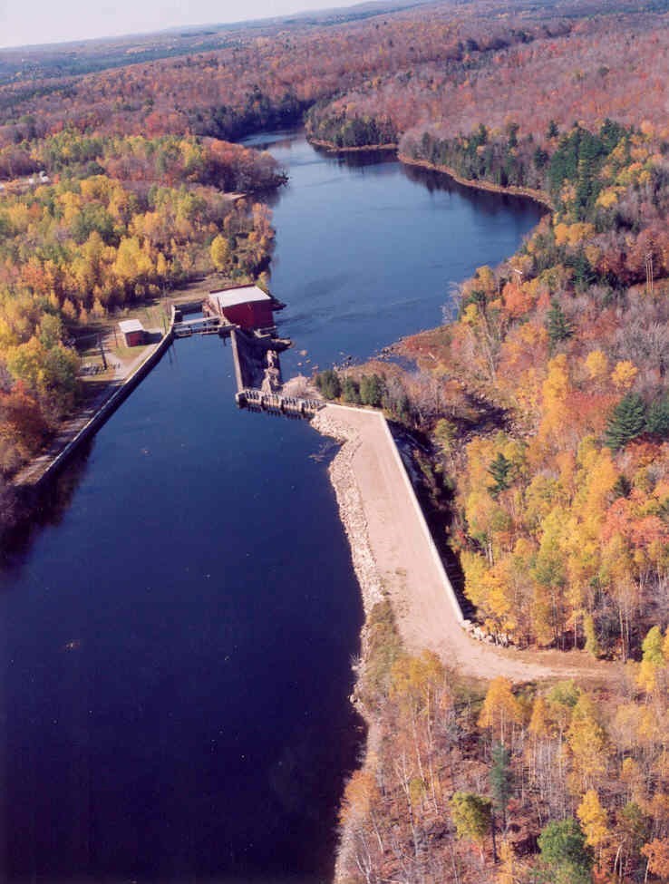
Le projet comprend : le barrage, le mur de soutènement, le batardeau déversoir, ogive déversoir, bief contourné, centrale électrique, une verticale Turbine Francis, et deux doubles horizontaux Turbines Francis./p>
Le barrage est un barrage en béton et en bois de 7 mètres de haut, d'environ 91 mètres de long, avec un mur de soutènement/digue de 150 mètres de long sur la rive droite. Un mur de soutènement de 213 mètres de long est situé le long de la rive gauche. déversoirs inclure un type de poteau de 118 pieds de long journal d'arrêt déversoir et une section de déversoir en ogive de 294 pieds de long et 23 pieds de haut avec un gonflable Obermeyer de 2 pieds de haut tableau flash Le barrage comporte un système de retenue et un mur de soutènement de 33 mètres de long. Un tronçon contourné de 168 mètres de long est créé par le barrage. La centrale comprend une unité Francis verticale et deux unités Francis doubles horizontales, d'une puissance combinée de 2,7 MW.
Le projet fonctionne dans un environnement modifié au fil de l'eau Le projet prévoit un débit minimal de 150 pi³/s dans le canal de fuite et maintient les fluctuations de retenue à 30 cm du sommet du réservoir. tableaux d'affichageCe régime d'écoulement a été élaboré en collaboration avec le Département de la conservation de l'environnement de l'État de New York (NYSDEC), le Service américain de la pêche et de la faune sauvage (USFWS), l'Agence du parc des Adirondacks et New York Rivers United. Les parties concernées s'accordent à dire que ce régime d'écoulement offre un habitat adéquat en aval et maintient une zone tampon végétale stable autour du réservoir. Un débit supplémentaire de 20 pi³/s est prévu plus en aval dans le tronçon contourné afin d'attirer les flux loin des prises d'eau et de minimiser la présence de poissons. entraînement et de fournir un passage en aval.
Les eaux à portée du projet sont désignées comme classe C. Il n'y a pas d'eaux dégradées à proximité du projet et le NYSDEC a confirmé que le projet continue de répondre à tous les groupes d'utilisation désignés.
Les chutes d'eau et les plans d'eau en aval créent des obstacles naturels au passage des espèces de poissons migrateurs dans le cadre du projet. Le tronçon du projet abrite des populations de poissons résidents : perchaude, doré jaune, crapet de roche, achigan à petite bouche, grand corégone, ouistiti et méné jaune. Le doré jaune est particulièrement abondant dans la zone du projet. Le débit minimal requis de 150 pi³/s soutient les ressources halieutiques en aval du projet, tandis que la dérivation de 20 pi³/s en aval assure un passage adéquat, et des grilles à débris espacées de 1 pouce limitent le risque d'entraînement. Cette conception a été approuvée par le NYSDEC et l'USFWS pour la protection du passage en aval.
Le terrain du projet, d'une superficie d'environ 7 hectares, est situé dans le parc d'État des Adirondacks. Il est régi par l'article 577 de la loi sur les rivières sauvages, pittoresques et récréatives, qui restreint la construction de nouvelles structures, favorise la gestion forestière et exige une zone tampon le long des rives. Le projet est soumis à un plan de surveillance du débit et du niveau d'eau qui minimise les effets sur le littoral en limitant les fluctuations des retenues. Cela garantit une zone tampon végétale adéquate sur le littoral et minimise l'érosion.
Parmi les espèces menacées ou en voie de disparition potentiellement présentes à proximité du projet figurent le pygargue à tête blanche, le pygargue à tête blanche et le tétras du Canada. Le projet est conforme à la règle 4(d) de l'USFWS concernant la protection des populations de pygargues à tête blanche, ainsi qu'au plan de conservation du NYSDEC pour les pygargues à tête blanche. Ces dispositions imposent principalement d'éviter les opérations de déboisement pendant certaines périodes de nidification. Le NYSDEC a également déterminé que le projet n'avait aucun impact sur les populations de tétras du Canada. Suite à une consultation avec le NYSDEC en 2019, il a été conclu que les populations de pygargues à tête blanche se portent très bien dans l'État de New York et que les opérations du projet ne compromettent pas leur succès.
Les biens historiques situés dans la zone du projet comprennent le barrage et la centrale électrique de Piercefield, construits en 1899 par l'International Paper Company pour produire du papier journal. Le maître d'ouvrage a élaboré un plan de gestion des biens historiques en collaboration avec le Bureau de préservation historique de l'État (SHPO) afin d'identifier les biens historiques, d'assurer leur entretien et de faciliter leur rénovation. Le maître d'ouvrage a formé son personnel d'exploitation à effectuer des suivis hebdomadaires des biens historiques et à soumettre des rapports annuels au SHPO.
Les ressources récréatives du projet comprennent une rampe de mise à l'eau, des aires de mise à l'eau et de sortie des canoës et deux zones de pêche sur la rive. Le propriétaire du projet offre une remise à l'eau récréative de 750 pi³/s pendant cinq heures le dernier samedi de juin. L'accès public est gratuit.
État de conformité
Il n'existe aucune condition spécifique à l'établissement dans le certificat actuel
2025: Aucun changement important ni problème de conformité n'a été identifié. Le projet demeure conforme suite à l'examen annuel.
2024: Aucun changement important ni problème de conformité n'a été identifié. Le projet demeure conforme suite à l'examen annuel.
2023: Aucun changement important ni problème de conformité n'a été identifié. Le projet demeure conforme suite à l'examen annuel.
2022: Aucun changement important ni problème de conformité n'a été identifié. Le projet demeure conforme suite à l'examen annuel.
2021: Aucun changement ni problème de conformité n'a été signalé. Le projet reste conforme sur la base de l'examen annuel.
2020: Aucun changement ni problème de conformité n'a été signalé. Le projet reste conforme sur la base de l'examen annuel.
2019: Le rapport annuel pour le certificat actuel n’est pas encore entré en vigueur.
Historique des certifications
1er janvier 2022 : La durée du certificat LIHI a été prolongée conformément à la révision 2.05 du manuel de certification LIHI 2e édition publié le 1er janvier 2022. Reportez-vous au tableau des établissements ci-dessus pour connaître la nouvelle durée.
13 août 2019 : La décision de certifier le projet hydroélectrique de Piercefield est définitive. Aucun appel n'a été reçu pendant la période d'appel, qui s'est terminée le 9 août 2019. La nouvelle période de certification du projet s'étend du 26 avril 2019 au 25 avril 2024.
10 juillet 2019 : Le Low Impact Hydropower Institute a approuvé de manière préliminaire la certification à faible impact pour le projet hydroélectrique de Piercefield.
Cette décision est préliminaire en attendant la période d'appel de 30 jours. Seuls ceux qui ont commenté la demande initiale pendant la période de commentaires de 60 jours sont éligibles pour déposer un appel. Un tel appel doit inclure une explication sur la raison pour laquelle le projet ne répond pas aux critères du LIHI. Les demandes d'appel peuvent être soumises par courrier électronique à comments@lowimpacthydro.org avec « Projet hydroélectrique de Piercefield » en objet, ou par courrier adressé au Low Impact Hydropower Institute, 329 Massachusetts Ave, Suite 6, Lexington, MA 02420. Toutes les demandes seront publiées sur le site web. Le demandeur aura la possibilité de répondre, et toute réponse sera également publiée. Les demandes doivent être reçues avant 17 h, heure de l’Est, le 9 août 2019. Le dossier complet et le rapport des évaluateurs sont disponibles ci-dessous.
Si aucune demande d'appel n'est reçue et que la décision devient définitive, la période de certification du projet (en attente de LIHI #156) sera le 26 avril 2019 pour une durée de cinq (5) ans, qui expirera le 25 avril 2024.
1er mai 2019 : Le Low Impact Hydropower Institute a reçu une demande complète de certification à faible impact pour le projet hydroélectrique de Piercefield. Le LIHI sollicite les commentaires du public sur cette demande. Plus précisément, nous souhaitons savoir si, selon vous, le projet répond aux critères de certification à faible impact du LIHI, tels que révisés dans la 2e édition du manuel. Veuillez consulter le programme et les critères dans la version révisée du LIHI. Manuel et consultez ensuite les documents de candidature du projet ci-dessous.
Commentaires directement liés à des critères spécifiques du LIHI (débits, qualité de l'eau, passage des poissons, etc.) seront très utiles, mais tous les commentaires seront pris en compte. Les commentaires peuvent être soumis à l'Institut par courrier électronique à l'adresse comments@lowimpacthydro.org avec « Commentaires sur le projet Piercefield » dans la ligne d'objet, ou par courrier adressé au Low Impact Hydropower Institute, 329 Massachusetts Avenue, Suite 6, Lexington, MA 02420. Les commentaires doivent être reçus au plus tard à 17 h, heure de l'Est, le 30 juin 2019. à prendre en considération. Tous les commentaires seront publiés sur le site Web et le candidat aura la possibilité d'y répondre. Toute réponse sera également publiée.